Items Similar to 1944 original map Les vins de Champagne – Vignobles du Bar-Séquanais

Want more images or videos?
Request additional images or videos from the seller
1 of 8
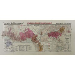
Louis Larmat1944 original map Les vins de Champagne – Vignobles du Bar-Séquanais1944
1944
$1,184.12
£895.96
€1,000
CA$1,657.66
A$1,808.01
CHF 952.67
MX$21,682.82
NOK 11,995.27
SEK 11,191.34
DKK 7,617.60
About the Item
The 1944 original map "Atlas de la France Vinicole – Les vins de Champagne – Vignobles du Bar-Séquanais et du Bar-sur-Aubois", created by Louis Larmat and printed by Dorel in Paris, is an exceptional cartographic representation of the Champagne wine-growing regions in the Bar-Séquanais and Bar-sur-Aubois areas. Part of Larmat’s comprehensive "Atlas de la France Vinicole", this map emphasizes the distinctive characteristics of these two viticultural zones, offering invaluable insights into the geographical and climatic factors that shape the wines of this less-known but historically rich part of Champagne.
Louis Larmat, renowned for his precision and dedication to capturing the terroir of France’s wine regions, produced this map as part of his extensive work in documenting the country’s diverse wine landscapes. His focus on the Vignobles du Bar-Séquanais et du Bar-sur-Aubois highlights an important region of Champagne, sometimes overshadowed by more famous areas like the Montagne de Reims or the Côte des Blancs, yet vital to the region’s history and production.
The Bar-Séquanais and Bar-sur-Aubois vineyards are located in the Aube department, a southern extension of the Champagne region. This area is distinct from the northern vineyards of Marne due to its geographical makeup and climate. The terroir here is characterized by Kimmeridgian marl, a type of limestone-rich soil also found in regions like Chablis, which gives the wines a unique mineral quality. Larmat’s map illustrates the undulating landscapes, hills, and valleys that define the Aube region, offering a detailed view of how these natural features contribute to the terroir.
In the Bar-sur-Aubois area, known for producing high-quality Pinot Noir, Larmat’s map highlights key wine-growing villages like Les Riceys, famous for its Rosé des Riceys, a rare still rosé wine produced in this part of Champagne. The climate here, slightly warmer than the northern part of Champagne, allows for a longer growing season, which is particularly beneficial for Pinot Noir. The map meticulously details the vineyards’ location, exposure to sunlight, and elevation, which are crucial factors in the development of the grape's character and the resulting wine.
The Bar-Séquanais region, also included on Larmat’s map, shares many similarities with Bar-sur-Aubois in terms of its soil composition and grape varieties. However, it is known for producing more balanced wines, often blending Pinot Noir, Chardonnay, and Pinot Meunier. The map shows the proximity of these vineyards to the Seine River, which has a moderating influence on the local climate, helping to reduce the risk of frost and creating a more stable environment for vine growth.
Larmat’s attention to detail extends beyond just the geography. The map also provides a historical context for the Bar-Séquanais and Bar-sur-Aubois regions, illustrating their long-standing importance in Champagne’s winemaking tradition. Although less internationally renowned, the wines from this region are appreciated for their complexity and depth, often forming the backbone of blends used by larger Champagne houses.
This 1944 map was produced during the final stages of World War II, a time when France’s cultural and economic infrastructure was under strain. Despite these challenges, the production of this map highlights the enduring importance of Champagne and its vineyards to French identity. Louis Larmat's work, particularly this map of the Bar-Séquanais and Bar-sur-Aubois, stands as a testament to France’s commitment to preserving and celebrating its wine heritage, even during difficult times.
Beyond its utility as a viticultural reference, the map is also an artistic achievement. The finely crafted typography, subtle use of color, and intricate detailing of the landscape make it a decorative piece that appeals to both wine lovers and collectors of fine cartographic works. The map serves not only as a practical guide to understanding the specific terroirs of these Champagne sub-regions but also as a celebration of the rich cultural and historical significance of French winemaking.
The 1944 map "Vignobles du Bar-Séquanais et du Bar-sur-Aubois", from Larmat’s Atlas de la France Vinicole and printed by Dorel in Paris, offers an invaluable glimpse into a lesser-known yet vital part of the Champagne region. Through Larmat’s careful attention to the geographical and historical details, the map captures the essence of these sub-regions, showcasing the interplay between soil, climate, and tradition that defines the wines produced here. For collectors, wine enthusiasts, and historians alike, this map remains a valuable artifact that illuminates the complexity and diversity of France’s most famous wine region.
Original Poster
Alcohol - Map - Marne - France
Dorel - Paris
- Creator:Louis Larmat
- Creation Year:1944
- Dimensions:Height: 25.6 in (65 cm)Width: 17.72 in (45 cm)
- Medium:
- Period:
- Condition:Good condition, original folds, two small tears.
- Gallery Location:PARIS, FR
- Reference Number:1stDibs: LU1792215255632
About the Seller
5.0
Gold Seller
Premium sellers maintaining a 4.3+ rating and 24-hour response times
Established in 2021
1stDibs seller since 2022
194 sales on 1stDibs
Typical response time: 1 hour
- ShippingRetrieving quote...Shipping from: PARIS, France
- Return Policy
More From This Seller
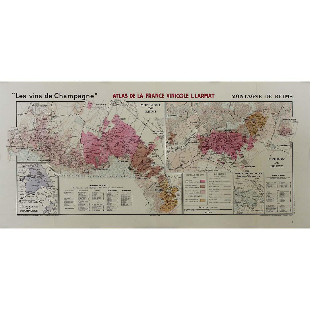
View All1944 original map "Les vins de Champagne – Montagne de Reims" by Louis Larmat
Located in PARIS, FR
The 1944 original map "Atlas de la France Vinicole – Les vins de Champagne – Montagne de Reims" by Louis Larmat is an exquisite piece of cartography that reflects both the history an...
Category
1940s Prints and Multiples
Materials
Paper, Lithograph
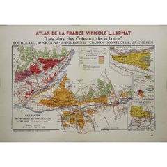
1946 original map "Les vins des côteaux de la Loire - Bourgueil" by Larmat
Located in PARIS, FR
The 1946 original map Atlas de la France Vinicole - Les Vins des Côteaux de la Loire: Bourgueil, St Nicolas-de-Bourgueil, Chinon, Montlouis, Jasnières, created by Louis Larmat and pr...
Category
1940s Prints and Multiples
Materials
Paper, Lithograph
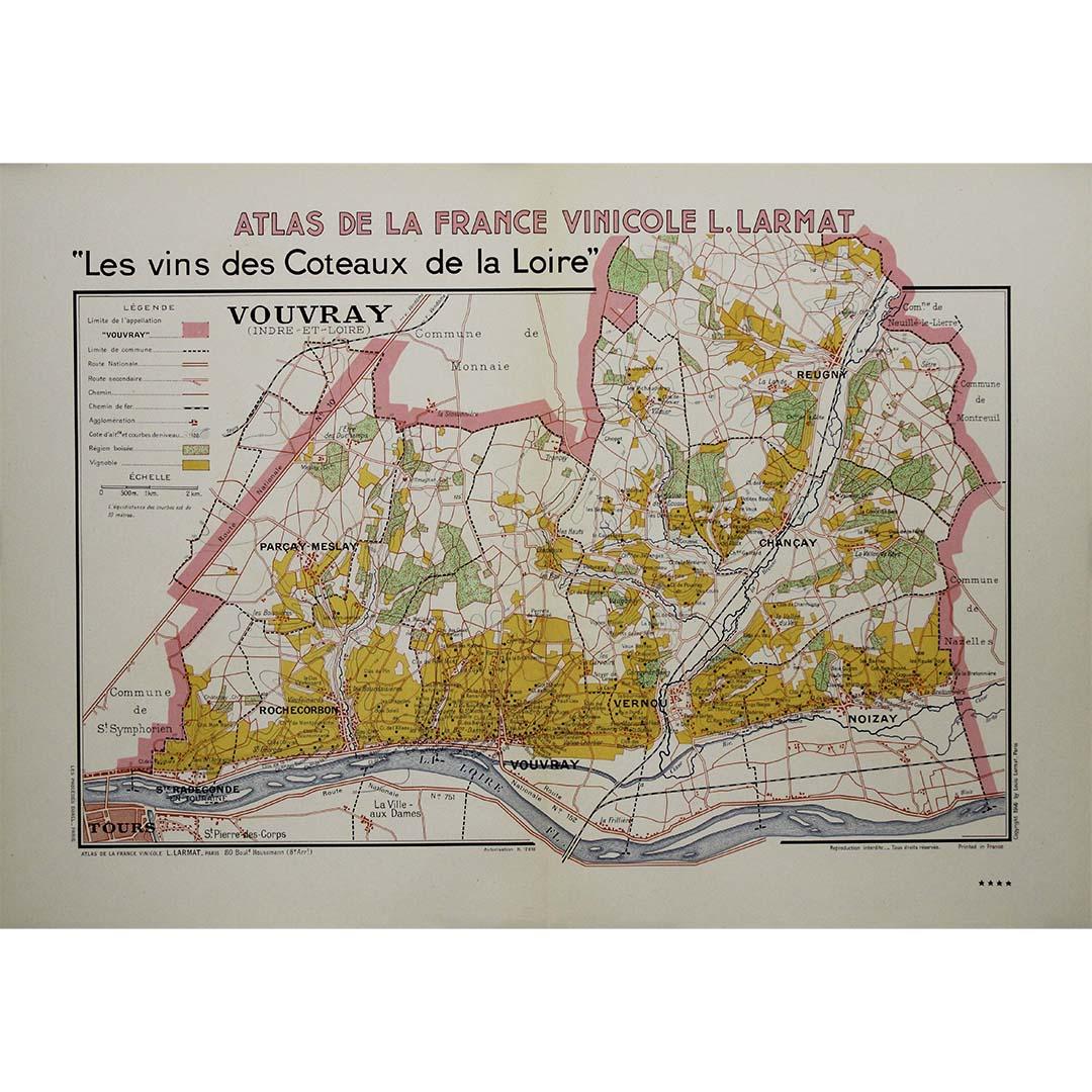
1946 original map "Les vins des côteaux de la Loire - Vouvray " by Larmat
Located in PARIS, FR
The 1946 map titled Atlas de la France Vinicole - Les Vins des Côteaux de la Loire: Vouvray by Louis Larmat, printed by Dorel in Paris, presents an intimate exploration of one of the...
Category
1940s Prints and Multiples
Materials
Paper, Lithograph

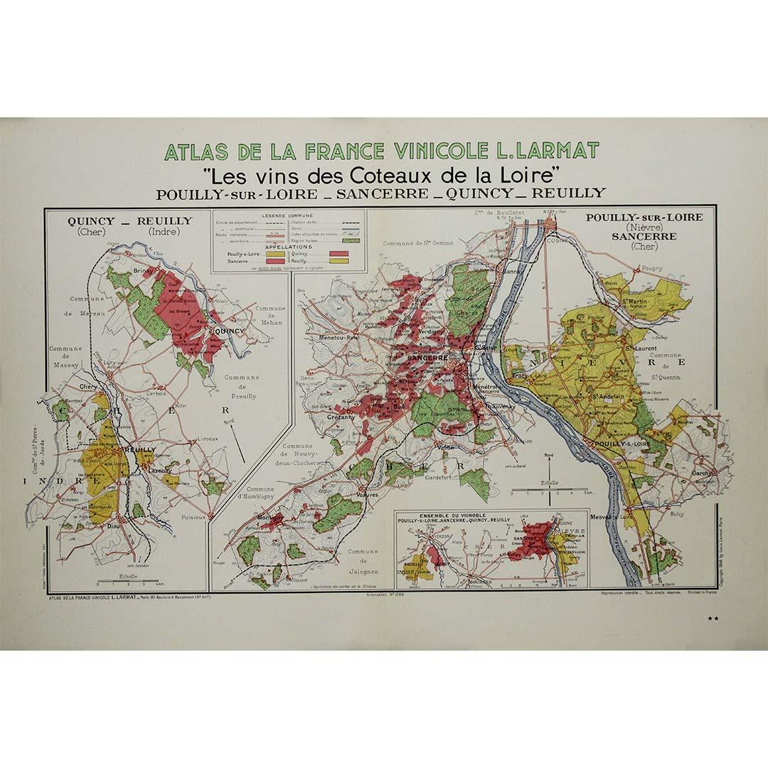
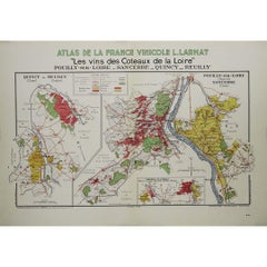
1946 original map "Les vins des côteaux de la Loire - Pouilly-sur-Loire" Larmat
Located in PARIS, FR
The 1946 original map Atlas de la France Vinicole - Les Vins des Côteaux de la Loire: Pouilly-sur-Loire, Sancerre, Quincy, Reuilly, created by Louis Larmat and printed by Dorel in Pa...
Category
1940s Prints and Multiples
Materials
Paper, Lithograph
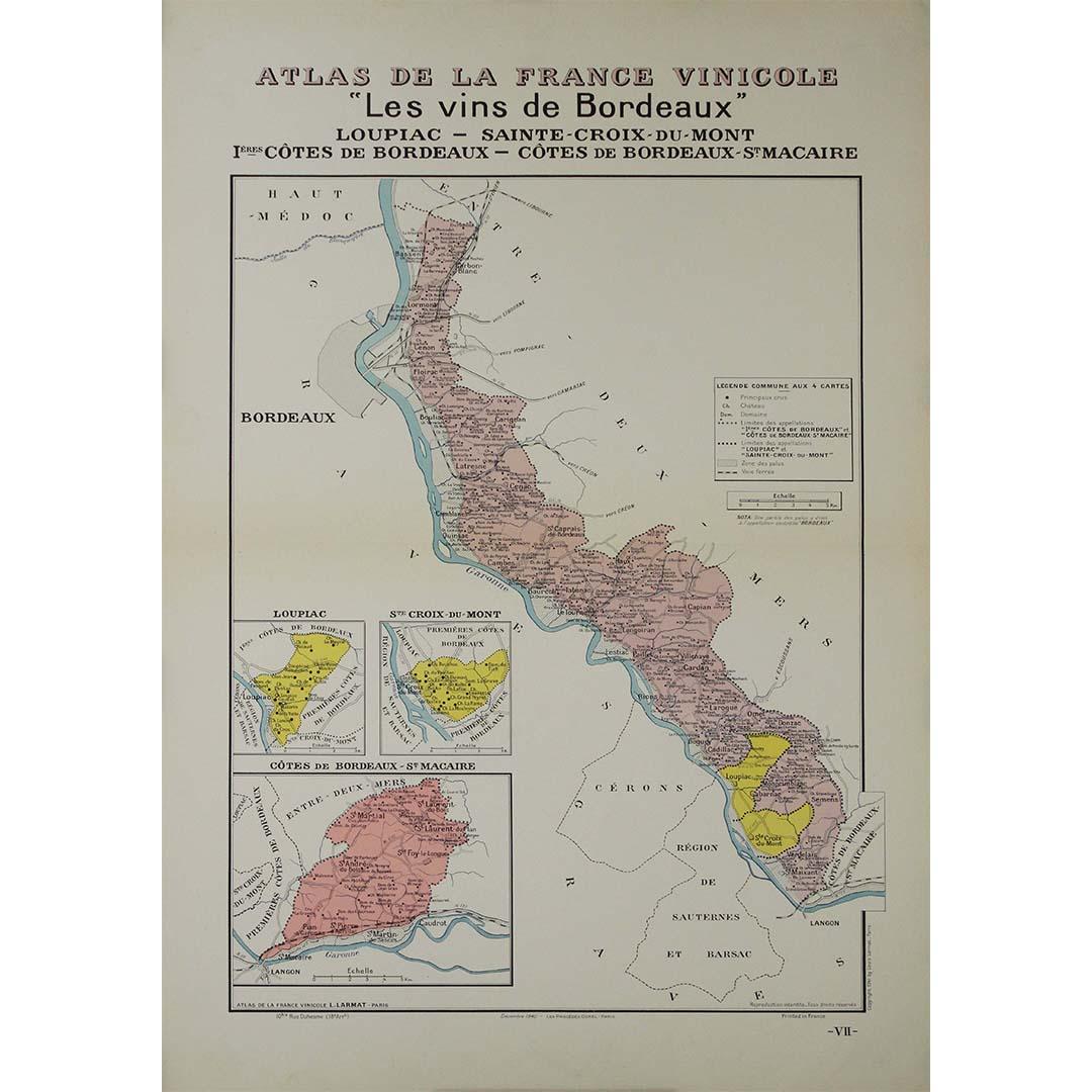
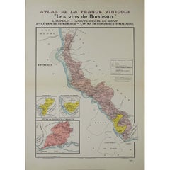
1941 original map "Les vins de Bordeaux - Loupiac, ..." by Larmat
Located in PARIS, FR
In 1941, L. Larmat crafted an exquisite map titled Atlas de la France Vinicole: Les Vins de Bordeaux - Loupiac, Sainte-Croix-du-Mont, Ières Côtes de Bordeaux, Côtes de Bordeaux St. M...
Category
1940s Prints and Multiples
Materials
Paper, Lithograph
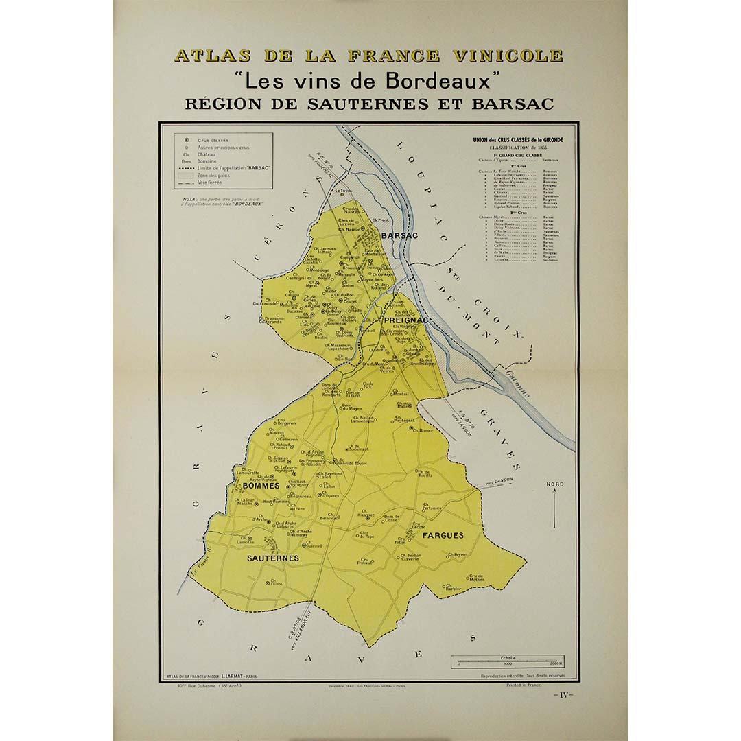
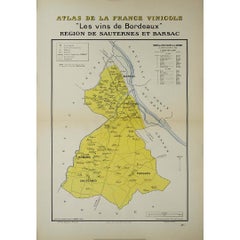
1941 original map "Les vins de Bordeaux - Régions de Sauternes" by Larmat
Located in PARIS, FR
The 1941 original map by L. Larmat, titled "Atlas de la France vinicole – Les vins de Bordeaux: Régions de Sauternes et Barsac", provides an intricate and precise depiction of two of...
Category
1940s Prints and Multiples
Materials
Paper, Lithograph
You May Also Like
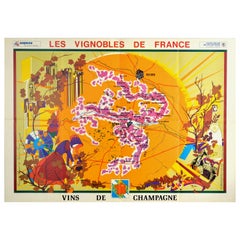
Original Vintage Poster Vineyards Of Champagne Wine Map Les Vignobles De France
Located in London, GB
Original vintage advertising poster for Les Vignobles de France Vins de Champagne / The Vineyards of France Wines of Champagne featuring a pictogra...
Category
Vintage 1960s French Posters
Materials
Paper
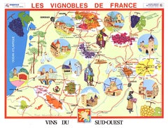
Original Vins du Sud-Ouest vintage French wine map poster
Located in Spokane, WA
Original Les Vignobles de France , Vins du Sud-Quest French vintage wine map poster. Horizontal. Size 36.5" x 27". Archival linen backed and re...
Category
Late 20th Century American Modern Landscape Prints
Materials
Lithograph
Original Vintage Poster Vignobles De France Vins Du Val De Loire Valley Wine Map
Located in London, GB
Original vintage drink advertising poster promoting French wines (one of a series issued by the Comite National de Propagande en Faveur du Vin national committee for the promotion of...
Category
Vintage 1950s French Posters
Materials
Paper
Original Vins Des Côtes du Rhône, French Wine Map vintage poster
Located in Spokane, WA
Original Les Vignobles de France - Cote du Rhone vintage wine map poster. Horizontal. Size 36.5" x 27". Archival linen backed and ready to fram...
Category
Late 20th Century American Modern Landscape Prints
Materials
Lithograph
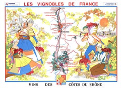
$600 Sale Price
20% Off
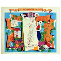
Original Vintage Poster Vignobles De France Vins De Bourgogne Burgundy Wine Map
Located in London, GB
Original vintage drink advertising poster promoting French wines (one of a series issued by the Comite National de Propagande en Faveur du Vin national committee for the promotion of...
Category
Vintage 1950s French Posters
Materials
Paper
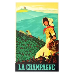
Original Vintage Poster La Champagne France Sparkling Wine Drink Vineyard Grapes
By Adrien Sénéchal
Located in London, GB
Original vintage travel poster for La Champagne featuring a great illustration by Adrien Senechal (1895-1974) of ladies in yellow dresses with bonnet hats and red scarves picking grapes in a vineyard with a lady in the foreground smiling towards the viewer and holding a basket of grapes in one arm, the rolling green hills leading to a windmill in the distance and the title text in bold lettering below. The historical province of Champagne in northeast France is best known as the Champagne wine region for sparkling white wine drink...
Category
Vintage 1930s French Posters
Materials
Paper