Items Similar to 1947 original map Gouvernement Généraux du Poitou, du Pays d'Aunis


Want more images or videos?
Request additional images or videos from the seller
1 of 8
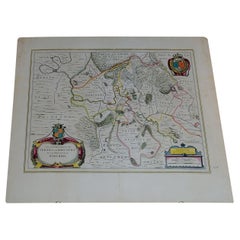
Louis Larmat1947 original map Gouvernement Généraux du Poitou, du Pays d'Aunis1947
1947
$1,313.11
£974.39
€1,100
CA$1,831.41
A$1,983.87
CHF 1,044.59
MX$24,080.03
NOK 13,027.30
SEK 12,317
DKK 8,376.06
About the Item
The 1947 original map Gouvernement Généraux du Poitou, du Pays d'Aunis et de Saintonge Angoumois, created by Louis Larmat and printed by Dorel in Paris, is a beautifully detailed cartographic representation of a historically significant region in western France. This map, part of Larmat’s extensive body of work, is known for its artistic craftsmanship and geographical precision, offering a comprehensive view of the historical administrative regions of Poitou, Aunis, Saintonge, and Angoumois, which played key roles in the political and cultural history of France.
Louis Larmat is celebrated for his contributions to cartography, particularly for his ability to merge historical context, topographical detail, and aesthetic elegance in his maps. His works, especially those focusing on the vinicultural regions of France, are highly respected for their accuracy and artistry. This particular map, although focusing on a more political and historical aspect rather than the wine regions he is most famous for, continues his tradition of detailed regional documentation. Larmat’s cartographic works often transcended the realm of simple geographical depiction, becoming historical documents that encapsulate the cultural essence of the regions they portray.
This map illustrates the general governments (administrative divisions) of the provinces of Poitou, Aunis, Saintonge, and Angoumois, regions that are steeped in history. These areas, situated along France’s western coastline, have been integral to the country’s political, economic, and cultural development over centuries. The region of Poitou, for example, is historically known as the birthplace of Eleanor of Aquitaine, one of the most famous figures of medieval Europe. Aunis and Saintonge, coastal regions with strong maritime traditions, played significant roles in France’s colonial expansion and in its maritime trade. Angoumois, located further inland, was a key center for agricultural production and the distillation of Cognac.
Larmat’s map is an invaluable resource for historians, geographers, and those interested in the cultural heritage of France. The map meticulously outlines the boundaries of these historic provinces, showing the towns, rivers, and roads that connected these regions. The Poitou region, shown on the map, encompasses the area now known as part of Nouvelle-Aquitaine, while Aunis and Saintonge form part of the Charente-Maritime department, renowned for its connection to Cognac production and its historical ties to maritime trade. Angoumois, with its inland location, is shown to cover much of the modern-day Charente department, further underlining its role in Cognac distillation.
What makes Larmat’s map stand out is not only its geographical accuracy but also its attention to the physical and cultural landscape. The map’s visual details, such as the depiction of topographical features, including rivers, forests, and coastlines, provide insight into the natural environment of the region. The inclusion of important historical towns like La Rochelle, Saintes, Angoulême, and Poitiers, allows the viewer to understand the region’s historical importance and the development of its urban centers over time.
In terms of artistry, the map features the hand-colored detailing that is characteristic of Larmat’s cartographic works. The boundaries of the provinces are carefully delineated with vibrant colors, making the regions easily distinguishable while also providing an aesthetically pleasing representation. The map’s title, Gouvernement Généraux du Poitou, du Pays d'Aunis et de Saintonge Angoumois, is elegantly displayed, and the borders are decorated with ornamental designs that reflect the cultural richness of these historic areas. Larmat’s combination of accurate cartography with artistic embellishments elevates the map beyond its practical use, making it a piece of art in its own right.
One of the significant aspects of this map is its historical context. Produced in the aftermath of World War II, the map reflects a period in France when there was a renewed interest in regional identity and cultural heritage. The regions of Poitou, Aunis, Saintonge, and Angoumois had been shaped by centuries of history, from their roles in medieval power struggles to their involvement in France’s colonial enterprises. By depicting these regions in such detail, Larmat contributes to the post-war effort to preserve and promote France’s regional cultures, which were seen as vital to rebuilding national identity.
The economic history of these regions is also subtly reflected in the map. The Saintonge and Angoumois regions, for example, are part of the broader Cognac-producing area, and their inclusion in the map points to the economic importance of agriculture and distillation in this part of France. Aunis, with its proximity to the Atlantic, is shown as a region historically tied to maritime commerce, which was critical for France’s economy, especially during the era of colonial expansion. By highlighting these aspects, Larmat’s map serves as both a geographical and an economic document, showing how these regions contributed to the broader French economy and culture.
The map also captures the architectural and urban development of these historic regions. Important towns like La Rochelle, with its fortified port and historical significance as a Protestant stronghold during the French Wars of Religion, and Angoulême, known for its Renaissance architecture and its role in the production of Cognac, are prominently displayed. These towns are marked not just as geographical locations but as centers of historical, cultural, and economic importance.
Today, this 1947 map by Louis Larmat is a prized item for collectors and historians. Its artistic value, combined with its historical significance, makes it a sought-after piece for those with an interest in French regional history and cartography. The map offers a window into the past, allowing viewers to explore the rich historical tapestry of Poitou, Aunis, Saintonge, and Angoumois. For modern audiences, it serves as both a decorative piece and an educational tool, offering insights into the historical boundaries and regional identities that continue to shape France to this day.
Larmat’s Gouvernement Généraux du Poitou, du Pays d'Aunis et de Saintonge Angoumois is more than just a map—it is a tribute to the historical legacy of western France. Through his meticulous craftsmanship and attention to both artistic and geographical detail, Larmat has created a work that not only informs but also inspires. Whether viewed as a historical document, a piece of art, or a collector’s item, this map remains a valuable testament to the enduring significance of these regions in the broader history of France.
Original Poster
Alcohol - Map - Charente - France
Atlas of wine-growing France
Dorel - Paris
- Creator:Louis Larmat
- Creation Year:1947
- Dimensions:Height: 17.72 in (45 cm)Width: 25.6 in (65 cm)
- Medium:
- Period:
- Condition:Good condition, original folds.
- Gallery Location:PARIS, FR
- Reference Number:1stDibs: LU1792215285712
About the Seller
5.0
Gold Seller
Premium sellers maintaining a 4.3+ rating and 24-hour response times
Established in 2021
1stDibs seller since 2022
182 sales on 1stDibs
Typical response time: 2 hours
- ShippingRetrieving quote...Shipping from: PARIS, France
- Return Policy
Authenticity Guarantee
In the unlikely event there’s an issue with an item’s authenticity, contact us within 1 year for a full refund. DetailsMoney-Back Guarantee
If your item is not as described, is damaged in transit, or does not arrive, contact us within 7 days for a full refund. Details24-Hour Cancellation
You have a 24-hour grace period in which to reconsider your purchase, with no questions asked.Vetted Professional Sellers
Our world-class sellers must adhere to strict standards for service and quality, maintaining the integrity of our listings.Price-Match Guarantee
If you find that a seller listed the same item for a lower price elsewhere, we’ll match it.Trusted Global Delivery
Our best-in-class carrier network provides specialized shipping options worldwide, including custom delivery.More From This Seller
View All1947 original map "Les eaux-de-vie de France - Le Cognac fins bois" by Larmat
Located in PARIS, FR
The 1947 original map Atlas de la France Vinicole - Les Eaux-de-vie de France - Le Cognac Fins Bois, created by Louis Larmat and printed by Dorel in Paris, is an exquisite piece that...
Category
1940s Prints and Multiples
Materials
Lithograph, Paper
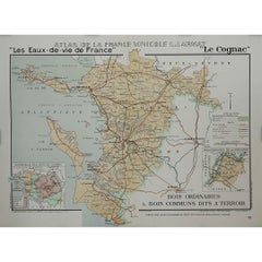
1947 original map "Le Cognac Bois ordinaires & Bois communs" by Larmat
Located in PARIS, FR
The 1947 original map Atlas de la France Vinicole - Les Eaux-de-vie de France - Le Cognac Bois Ordinaires & Bois Communs dits à Terroir, created by Louis Larmat and printed by Dorel ...
Category
1940s Prints and Multiples
Materials
Lithograph, Paper
1947 original map "Les eaux-de-vie de France - Le Cognac" by Larmat
Located in PARIS, FR
The 1947 original map Atlas de la France vinicole - Les eaux-de-vie de France - Le Cognac, created by Louis Larmat and printed by Dorel in Paris, is a fascinating and detailed cartog...
Category
1940s Prints and Multiples
Materials
Lithograph, Paper
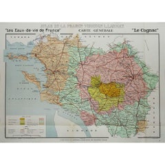
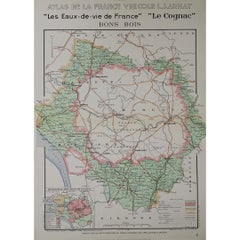
1947 original map "Les eaux-de-vie de France - Le Cognac Bons Bois" by Larmat
Located in PARIS, FR
The 1947 original map Atlas de la France Vinicole - Les Eaux-de-vie de France - Le Cognac Bons Bois, created by Louis Larmat and printed by Dorel in Paris, is a beautifully crafted c...
Category
1940s Prints and Multiples
Materials
Lithograph, Paper
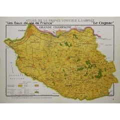
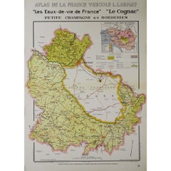
1947 original map "Les eaux-de-vie de France - Le Cognac petite Champagne"
Located in PARIS, FR
The 1947 original map Atlas de la France Vinicole - Les eaux-de-vie de France - Le Cognac Petite Champagne et Borderies, created by Louis Larmat and printed by Dorel in Paris, is a d...
Category
1940s Prints and Multiples
Materials
Lithograph, Paper
You May Also Like
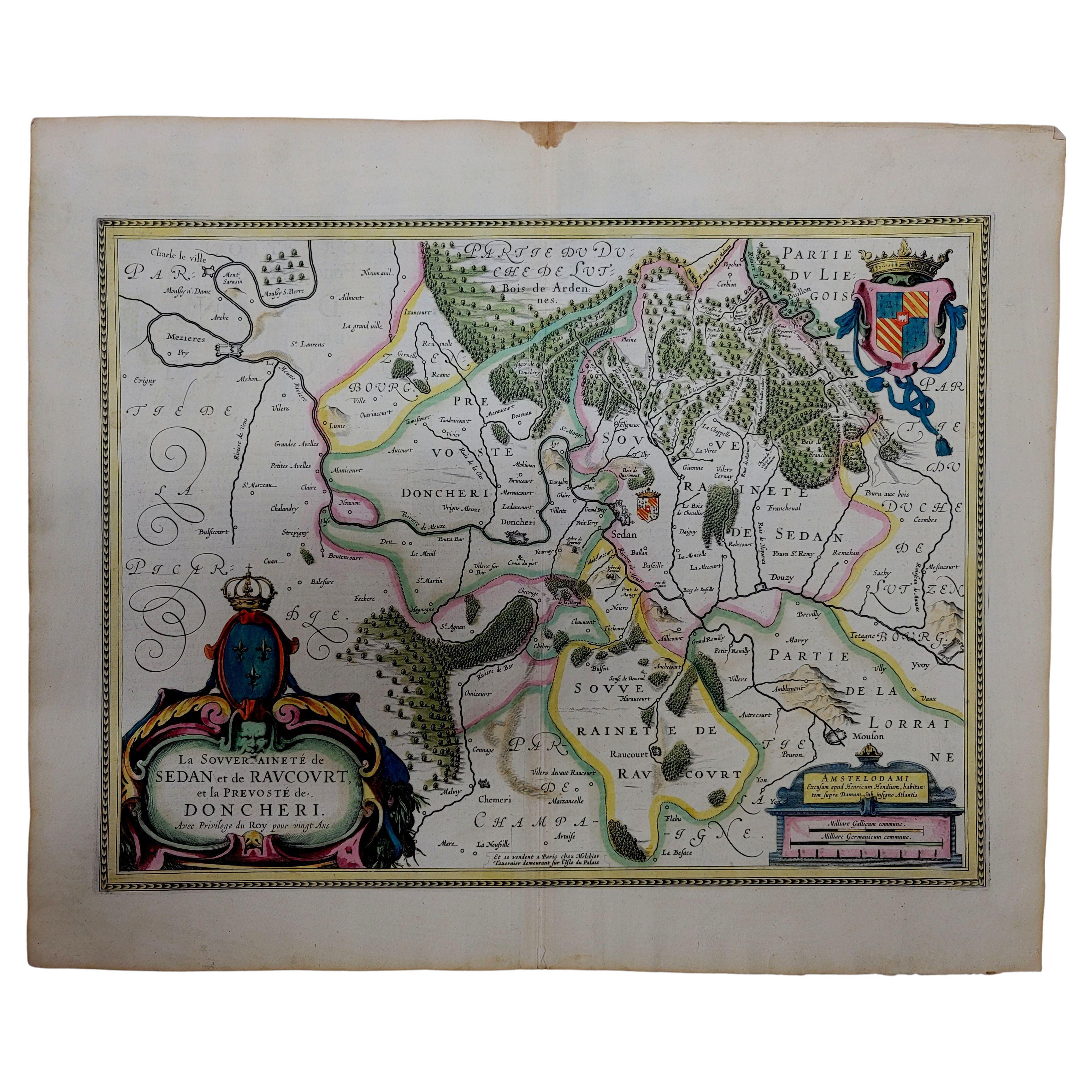
1633 Map "La Souverainete De Sedan Et De Raucourt, Et La Prevoste Ric0011
Located in Norton, MA
1653 map entitled
"La Souverainete de Sedan et de Raucourt, et la Prevoste de Doncheri,"
Ric0011
Description:
Lovely map centered on Sedan and Doncheri and the Meuze River fr...
Category
Antique 17th Century Dutch Maps
Materials
Paper

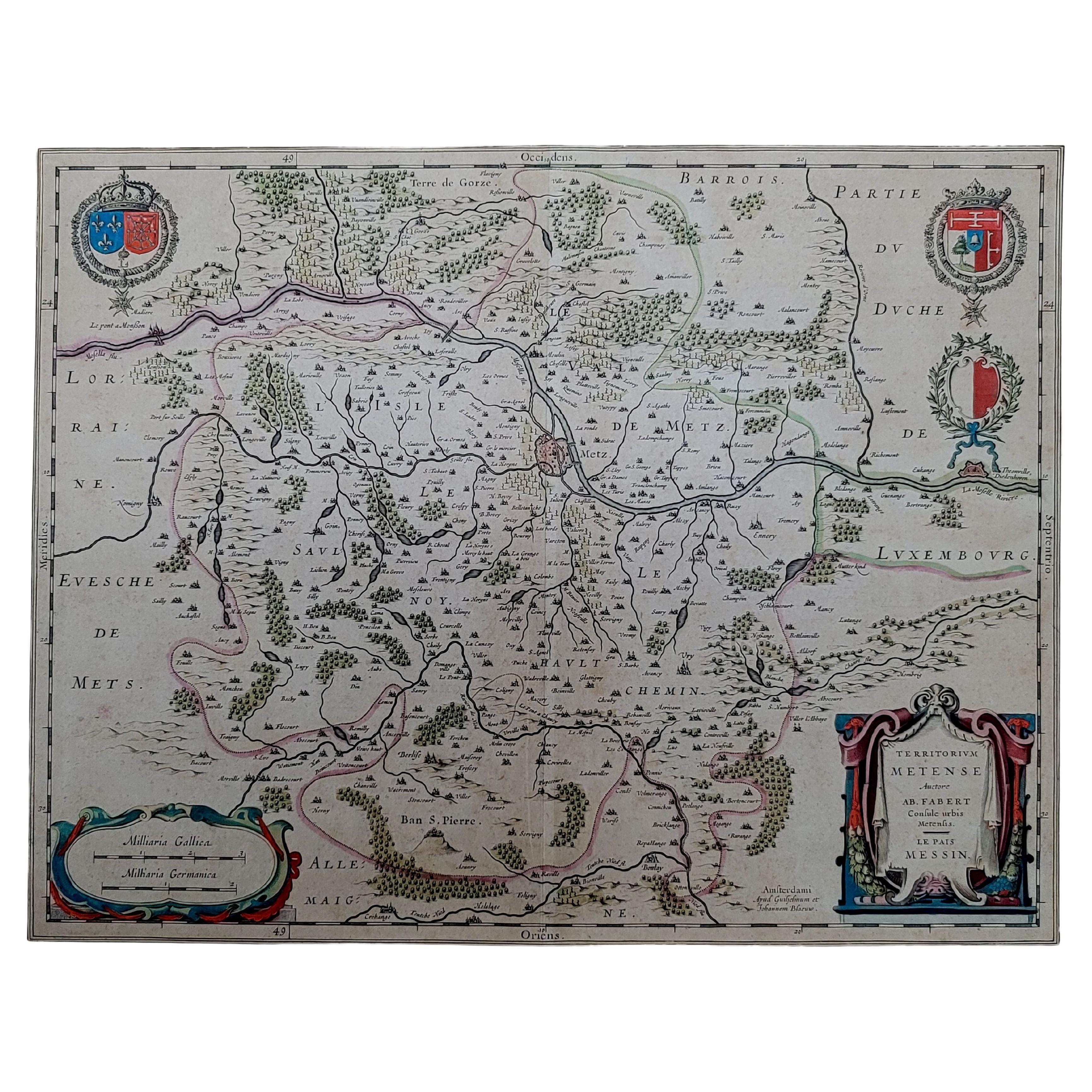
1656 Jansson Map Metz Region of France Entitled "Territorium Metense" Ric0014
Located in Norton, MA
1656 Jansson map Metz Region of France entitled "Territorium Metense."
Ric0014
" Authentic" - Map of the historical region surrounding Metz, in Lorraine, France.
Oriented with ...
Category
Antique 17th Century Dutch Maps
Materials
Paper

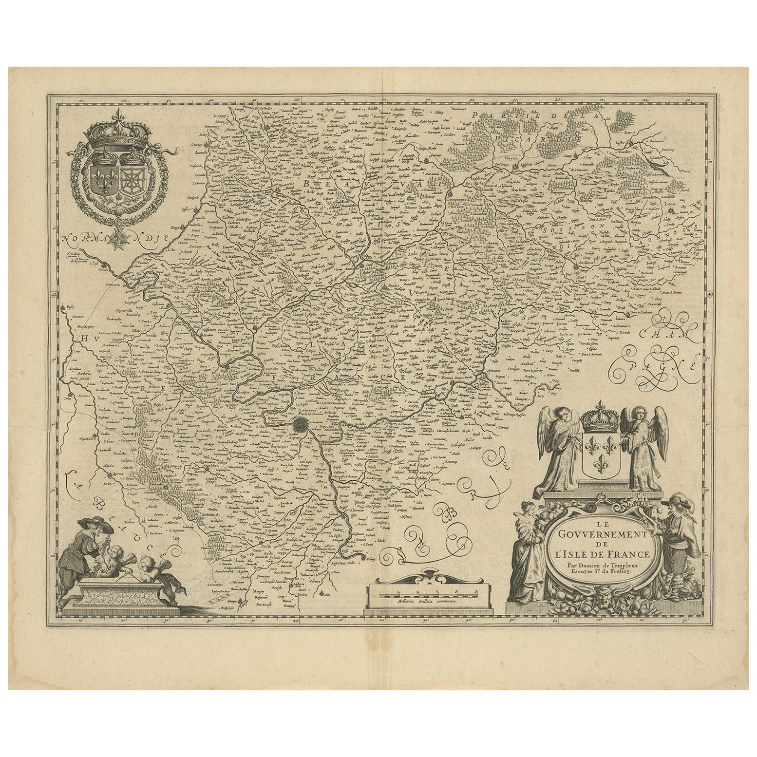
Antique Map of the Region of 'Île de France' by Janssonius, circa 1650
By Johannes Janssonius
Located in Langweer, NL
Antique map of France titled 'Le Gouvernement de L'Isle de France'. Paris is represented by a miniature plan of the city, making it distinct from the other towns of the region which ...
Category
Antique Mid-17th Century Maps
Materials
Paper
$429 Sale Price
20% Off
Original Antique Regional Map of France with Orleans, Auxerre and Montargis
By Johannes Janssonius
Located in Langweer, NL
Original antique map titled 'Gastinois et Senonois'. Beautiful regional map of France. With Corbeil in the north, Pont sur Seyne in the east, Auxerre in the south, and Orleans in the...
Category
Antique Mid-17th Century Maps
Materials
Paper
$802 Sale Price
20% Off
Antique Map of Guyenne, Gascony and Béarn, France
Located in Langweer, NL
Antique map titled 'Guyenne et Gascogne et Bearn'. Original old map of Guyenne (or Guienne), Gascony and Béarn, France. This map originates from 'Le Petit Atlas Maritime Recueil De C...
Category
Antique Mid-18th Century Maps
Materials
Paper
$248 Sale Price
20% Off
1656 "La Souverainete de Sedan et de Raucourt, et la Prevoste de Doncheri Ric004
Located in Norton, MA
1656 map entitled
"La Souverainete de Sedan et de Raucourt, et la Prevoste de Doncheri,"
Hand Colored
Ric0004.
Description:
Lovely map centered on Sedan and Doncheri an...
Category
Antique 17th Century Dutch Maps
Materials
Paper
More Ways To Browse
The Vintage Map
Vintage French Map
Vintage Illustrated Maps
Alcohol Poster
Vintage Alcohol Posters
Map Stand
Eleanor Of Aquitaine
Egon Schiele And Max Jaffe
Erotic 1920
Harriet Tubman
Helen Frankenthaler Lincoln Center Posters
Hercules Print
Homage To Andy Warhol
I Have Been To Hell And Back
Iris Lithograph
Japanese Art Print Flower
Jewish Woodcut
Jules Perahim