Items Similar to 1947 original map "Les eaux-de-vie de France - Le Cognac fins bois" by Larmat


Want more images or videos?
Request additional images or videos from the seller
1 of 8
Louis Larmat1947 original map "Les eaux-de-vie de France - Le Cognac fins bois" by Larmat1947
1947
$1,188.63
£885.16
€1,000
CA$1,641.06
A$1,819.36
CHF 956.14
MX$22,265.95
NOK 11,941.26
SEK 11,208.07
DKK 7,613.67
About the Item
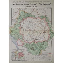
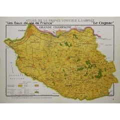
The 1947 original map Atlas de la France Vinicole - Les Eaux-de-vie de France - Le Cognac Fins Bois, created by Louis Larmat and printed by Dorel in Paris, is an exquisite piece that meticulously charts one of the key regions in Cognac production, known as Fins Bois. This map belongs to the comprehensive Atlas de la France Vinicole, a distinguished collection that documents the country’s wine and spirit-producing regions with a blend of scientific precision and artistic elegance. Larmat’s work is celebrated not only for its practical use but also for its cultural and historical value, making it a prized artifact for collectors, historians, and Cognac enthusiasts alike.
Louis Larmat, a revered French cartographer, devoted much of his career to mapping France’s viticultural regions, creating detailed works that highlight the intricate connections between geography, climate, and the production of France’s finest wines and spirits. His Atlas de la France Vinicole series is particularly admired for its attention to detail and for how it presents France’s wine and spirit-making regions in a visually appealing manner. The Fins Bois map focuses on one of the largest Cognac-producing areas, giving valuable insights into the characteristics of this region.
The Fins Bois region is one of the six Cognac crus, or delimited growth areas, and it plays a crucial role in the production of Cognac due to its extensive land and output. Situated around the Grande Champagne and Petite Champagne regions, Fins Bois forms a large ring around these central crus, extending out to the west and the north. The eaux-de-vie from Fins Bois are typically more robust and quicker to age than those from the heartland regions, contributing body and fruit-forward notes to Cognac blends. Larmat’s map showcases this important region, emphasizing its size and its geographical diversity, which ranges from chalky soils to clay and limestone, each imparting distinct characteristics to the eaux-de-vie produced there.
Larmat’s map is notable for its clear depiction of the boundaries and key features of the Fins Bois region. Villages, rivers, and notable landmarks are carefully plotted, giving a precise understanding of the area’s layout. The map also outlines the topographical features that influence Cognac production, including the varying soil compositions that differentiate Fins Bois from other Cognac crus. The detailed geographical representation highlights how the terroir of Fins Bois contributes to its role in the broader Cognac-making process, particularly in how its eaux-de-vie are often used to round out blends with their fruity, earthy, and slightly rustic character.
In addition to its geographical accuracy, the map features hand-colored elements that bring it to life. These colors help to distinguish the various subregions within Fins Bois, marking boundaries and making it easier to see where this cru connects to neighboring regions like Bons Bois and Borderies. Larmat’s use of color not only enhances the map’s visual appeal but also serves a functional purpose, making the map a valuable tool for those in the industry who need to understand the nuances of Cognac’s geographical diversity.
Larmat’s work also includes annotations that describe the characteristics of the eaux-de-vie produced in Fins Bois. These notes explain that Cognac from this region tends to have a fuller, rounder flavor profile, often with notes of fresh fruits, particularly grapes and apples. Fins Bois eaux-de-vie are also known for their faster aging process compared to those from the more central Cognac crus, making them ideal for inclusion in blends that require a robust and approachable character. These details would have been invaluable to producers, merchants, and educators at the time, providing a deeper understanding of the region’s contributions to Cognac production.
One of the distinguishing features of Larmat’s Atlas de la France Vinicole maps is their combination of artistry and technical precision. The Fins Bois map, like others in the series, is not just a cartographic tool; it is also a work of art. The typography is elegant, the placement of names and landmarks is meticulously balanced, and the overall design is aesthetically pleasing, making the map a decorative piece as well as a practical one. Collectors value these maps for their beauty as much as for their historical and geographical significance.
The map’s borders often include decorative flourishes that reflect the subject matter, such as grapevines, barrels, or motifs related to viticulture. These artistic details tie the map to the broader tradition of French craftsmanship and emphasize the deep cultural connection between geography and the production of fine spirits like Cognac. Larmat’s work celebrates this tradition, showcasing the pride that France takes in its terroir and the artisanal nature of its wine and spirit production.
In the context of the post-World War II era, when this map was created, there was a strong focus on re-establishing France’s position as a global leader in agriculture, especially in viticulture and spirit production. Cognac, in particular, had a long-standing international reputation, and the maps in Larmat’s Atlas de la France Vinicole played a role in both promoting and preserving this heritage. The Fins Bois map reflects the resurgence of interest in regional specialties and the renewed emphasis on the quality and distinctiveness of French terroir in the global market.
Today, Louis Larmat’s 1947 map of Fins Bois is a sought-after collectible, valued for its historical significance and its aesthetic appeal. Whether displayed as a work of art or studied for its cartographic precision, the map is a testament to the rich history of Cognac production in France. For historians, the map offers insights into how regions like Fins Bois were viewed and understood in the mid-20th century, while for connoisseurs and industry professionals, it serves as a reminder of the enduring importance of terroir in the crafting of fine Cognac.
Larmat’s Fins Bois map remains an important document in the legacy of French viniculture and spirit production, reflecting a time when maps were not only functional tools but also artistic expressions of national pride. Its detailed depiction of the Fins Bois region continues to be of value to anyone interested in the history, geography, and culture of Cognac, providing a unique window into the craftsmanship and tradition that define one of France’s most famous exports.
Original Poster
Alcohol - Map - Charente - France
Dorel - Paris
- Creator:Louis Larmat
- Creation Year:1947
- Dimensions:Height: 17.72 in (45 cm)Width: 24.81 in (63 cm)
- Medium:
- Period:
- Condition:Good condition, original folds.
- Gallery Location:PARIS, FR
- Reference Number:1stDibs: LU1792215285542
About the Seller
5.0
Gold Seller
Premium sellers maintaining a 4.3+ rating and 24-hour response times
Established in 2021
1stDibs seller since 2022
171 sales on 1stDibs
Typical response time: 1 hour
- ShippingRetrieving quote...Shipping from: PARIS, France
- Return Policy
Authenticity Guarantee
In the unlikely event there’s an issue with an item’s authenticity, contact us within 1 year for a full refund. DetailsMoney-Back Guarantee
If your item is not as described, is damaged in transit, or does not arrive, contact us within 7 days for a full refund. Details24-Hour Cancellation
You have a 24-hour grace period in which to reconsider your purchase, with no questions asked.Vetted Professional Sellers
Our world-class sellers must adhere to strict standards for service and quality, maintaining the integrity of our listings.Price-Match Guarantee
If you find that a seller listed the same item for a lower price elsewhere, we’ll match it.Trusted Global Delivery
Our best-in-class carrier network provides specialized shipping options worldwide, including custom delivery.More From This Seller
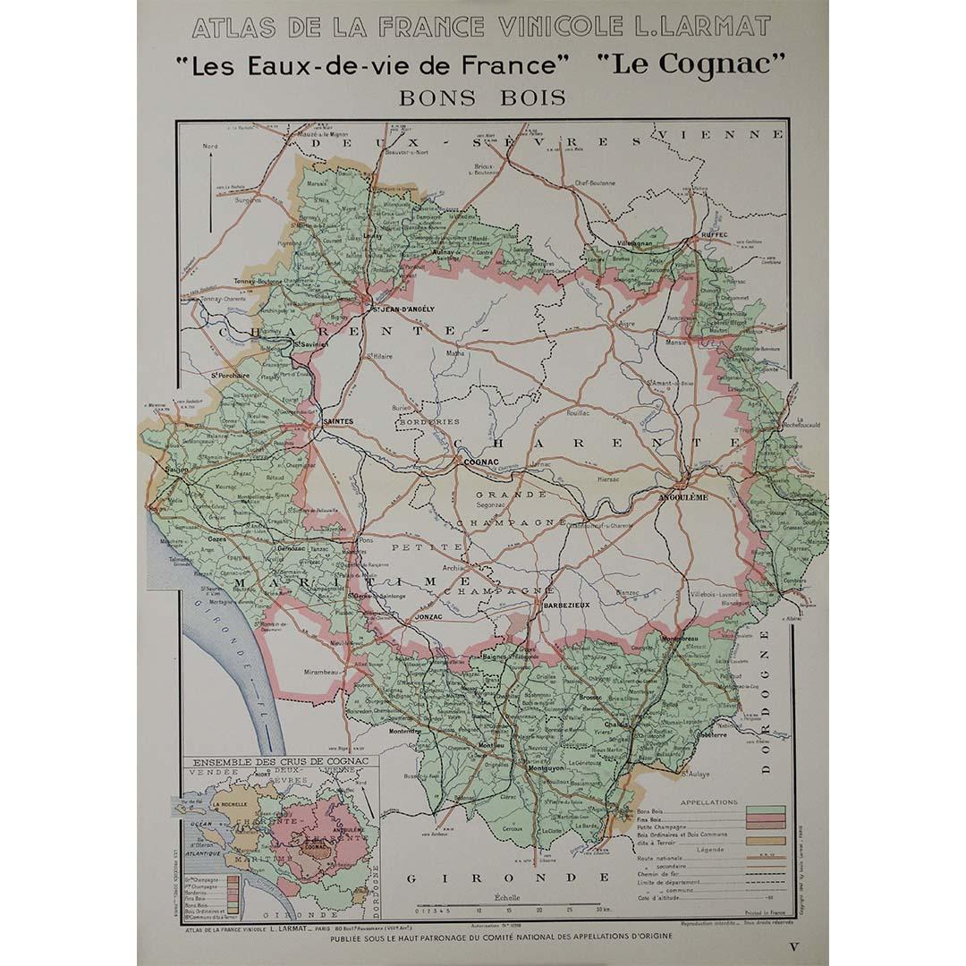
View All1947 original map "Les eaux-de-vie de France - Le Cognac Bons Bois" by Larmat
Located in PARIS, FR
The 1947 original map Atlas de la France Vinicole - Les Eaux-de-vie de France - Le Cognac Bons Bois, created by Louis Larmat and printed by Dorel in Paris, is a beautifully crafted c...
Category
1940s Prints and Multiples
Materials
Lithograph, Paper
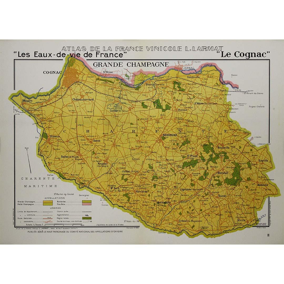
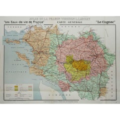
1947 original map "Les eaux-de-vie de France - Le Cognac" by Larmat
Located in PARIS, FR
The 1947 original map Atlas de la France vinicole - Les eaux-de-vie de France - Le Cognac, created by Louis Larmat and printed by Dorel in Paris, is a fascinating and detailed cartog...
Category
1940s Prints and Multiples
Materials
Lithograph, Paper
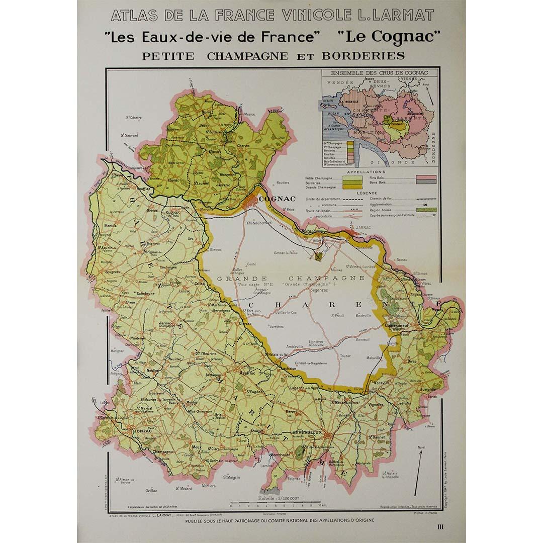
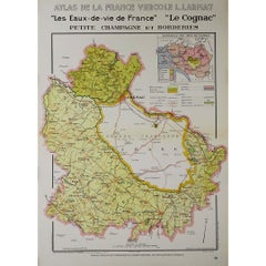
1947 original map "Les eaux-de-vie de France - Le Cognac petite Champagne"
Located in PARIS, FR
The 1947 original map Atlas de la France Vinicole - Les eaux-de-vie de France - Le Cognac Petite Champagne et Borderies, created by Louis Larmat and printed by Dorel in Paris, is a d...
Category
1940s Prints and Multiples
Materials
Lithograph, Paper
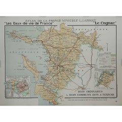
1947 original map "Le Cognac Bois ordinaires & Bois communs" by Larmat
Located in PARIS, FR
The 1947 original map Atlas de la France Vinicole - Les Eaux-de-vie de France - Le Cognac Bois Ordinaires & Bois Communs dits à Terroir, created by Louis Larmat and printed by Dorel ...
Category
1940s Prints and Multiples
Materials
Lithograph, Paper
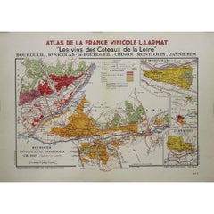
1946 original map "Les vins des côteaux de la Loire - Bourgueil" by Larmat
Located in PARIS, FR
The 1946 original map Atlas de la France Vinicole - Les Vins des Côteaux de la Loire: Bourgueil, St Nicolas-de-Bourgueil, Chinon, Montlouis, Jasnières, created by Louis Larmat and pr...
Category
1940s Prints and Multiples
Materials
Lithograph, Paper
You May Also Like
Antique Map of France by Johnston (1909)
Located in Langweer, NL
Antique map titled 'France'. Original antique map of France. With inset maps of France in provinces, part of the Riviera and Corsica. This map or...
Category
Early 20th Century Maps
Materials
Paper

$237 Sale Price
20% Off
Antique Map of France by Lapie, 1842
Located in Langweer, NL
Antique map titled 'Carte de France'. Map of France. This map originates from 'Atlas universel de géographie ancienne et moderne (..)' by Pierre M. Lapie and Alexandre E. Lapie. Pier...
Category
Antique Mid-19th Century Maps
Materials
Paper

$523 Sale Price
20% Off
1859 Classic Map of France: Blackie's Imperial Geographic Masterpiece
Located in Langweer, NL
The "Antique Map of France" from 'The Imperial Atlas of Modern Geography', published in 1859 by W. G. Blackie, is a historically valuable cartographic work that offers a comprehensiv...
Category
Antique Mid-19th Century Maps
Materials
Paper

$222 Sale Price
25% Off
Antique Map of France by Lapie, 1842
Located in Langweer, NL
Antique map titled 'Carte des Gaules'. Map of France. This map originates from 'Atlas universel de géographie ancienne et moderne (..)' by Pierre M. Lapie and Alexandre E. Lapie. Pie...
Category
Antique Mid-19th Century Maps
Materials
Paper

$475 Sale Price
20% Off
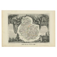
Antique Map of Côte d'Or ‘France’ by V. Levasseur, 1854
By Victor Levasseur
Located in Langweer, NL
Antique map titled 'Dépt. de la Côte d'Or'. Map of the French department of Cote D’Or, France. Part of France's Burgundy or Bourgogne wine region, a premier wine-growing region of Fr...
Category
Antique Mid-19th Century Maps
Materials
Paper
$142 Sale Price
20% Off
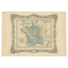
Antique Map of France under the Reign of Francois I, 1765
Located in Langweer, NL
Antique map France titled 'Etat des Possessions de la Couronne (..)'.
Beautiful old map of France. This map originates from 'Atlas Historique de la France Ancienne et Moderne' by...
Category
Antique 18th Century Maps
Materials
Paper
$140 Sale Price
20% Off
More Ways To Browse
French Finial
Post Finial
Used Wine Barrels
Vintage French Poster Wine
Vintage Agricultural Poster
French Grande Poster
Vintage Alcohol Posters
Ring 1947
French Poster Art Alcohol
Champagne Poster
Wine Region Poster
French Champagne Posters
Cartographer Tool
Vintage Champagne Poster
Louis Cognac
Original Vintage Champagne Posters
Vintage Apple Poster
Vintage Wine Barrels