Items Similar to 1851 Original map by Maillard - Plan de Paris et ses Fortifications

Want more images or videos?
Request additional images or videos from the seller
1 of 8
Maillard1851 Original map by Maillard - Plan de Paris et ses Fortifications1851
1851
$1,795.84
£1,332.52
€1,500
CA$2,508.16
A$2,720.16
CHF 1,428.73
MX$33,041.08
NOK 17,878.28
SEK 16,833.40
DKK 11,422.51
About the Item
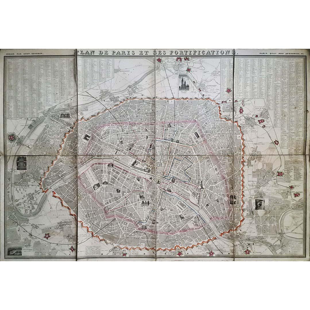
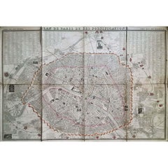
In the world of cartography, maps transcend mere geography; they are historical records and works of art, encapsulating the essence of a place at a specific moment in time. The 1851 vintage map, "Plan de Paris et ses Fortifications," masterfully crafted by the skilled geographer Maillard in collaboration with architect Alvar Toussaint and published by Auguste Logerot, offers an intricate and enlightening view of Paris during a period of significant transformation. This extraordinary map not only serves as a geographical reference but is a historical treasure that provides a deep insight into the city's layout, architectural landmarks, and formidable fortifications.
The 1851 "Plan de Paris et ses Fortifications" is a collaborative masterpiece, bringing together the talents of geographer Maillard, architect Alvar Toussaint, and publisher Auguste Logerot. Their combined expertise resulted in a cartographic gem that remains a valuable historical document.
In 1851, Paris was a city in the midst of a remarkable transformation. The 19th century marked a period of urban expansion and modernization, and this vintage map provides a unique perspective on the city's architectural diversity, including grand boulevards, intricate streets, and significant fortifications. Of particular note, the map prominently features two vital fortification walls: the Wall of the Farmers-General, constructed in 1790, and the Thiers Wall. Named after the statesman Adolphe Thiers, this wall was built between 1841 and 1844 at the behest of King Louis-Philippe. Its primary purpose was to encircle the capital with a bastioned wall, rendering Paris impregnable.
The "Plan de Paris et ses Fortifications" of 1851 is a visual journey through time, offering an authentic glimpse into Paris's past during a pivotal era of urban development. It not only preserves the historical importance of the city's fortifications but also reflects the ambition and vision of the city's leaders. Additionally, the map is adorned with vignettes depicting the city's monuments and suburbs, making it an artistic treasure that captivates both historians and art enthusiasts.
Map - Geography - France
Published by Auguste Logero
- Creator:Maillard
- Creation Year:1851
- Dimensions:Height: 30.71 in (78 cm)Width: 39.38 in (100 cm)
- Medium:
- Period:
- Condition:Good condition, folds, on linen.
- Gallery Location:PARIS, FR
- Reference Number:1stDibs: LU1792213261642
About the Seller
5.0
Gold Seller
Premium sellers maintaining a 4.3+ rating and 24-hour response times
Established in 2021
1stDibs seller since 2022
181 sales on 1stDibs
Typical response time: 2 hours
- ShippingRetrieving quote...Shipping from: PARIS, France
- Return Policy
Authenticity Guarantee
In the unlikely event there’s an issue with an item’s authenticity, contact us within 1 year for a full refund. DetailsMoney-Back Guarantee
If your item is not as described, is damaged in transit, or does not arrive, contact us within 7 days for a full refund. Details24-Hour Cancellation
You have a 24-hour grace period in which to reconsider your purchase, with no questions asked.Vetted Professional Sellers
Our world-class sellers must adhere to strict standards for service and quality, maintaining the integrity of our listings.Price-Match Guarantee
If you find that a seller listed the same item for a lower price elsewhere, we’ll match it.Trusted Global Delivery
Our best-in-class carrier network provides specialized shipping options worldwide, including custom delivery.More From This Seller
View All1848 Original map by Maillard - Plan de Paris et ses Fortifications
Located in PARIS, FR
In the realm of cartography, maps serve as both practical tools and artistic representations, encapsulating the essence of a place at a specific moment in time. The 1848 vintage map,...
Category
1840s Prints and Multiples
Materials
Paper, Linen, Lithograph
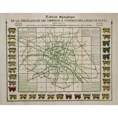
original poster of the Parisian public transportation system before 1854
Located in PARIS, FR
This remarkable original poster offers a snapshot of the Parisian public transportation system before 1854, capturing the intricate network of horse-drawn omnibuses that circulated t...
Category
1850s Prints and Multiples
Materials
Linen, Paper, Lithograph
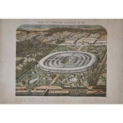
1867 original lithography for the Exposition Universelle in Paris
Located in PARIS, FR
The 1867 Exposition Universelle in Paris was one of the grandest World’s Fairs of the 19th century, showcasing industrial progress, cultural achievements, and artistic excellence. Th...
Category
1860s Prints and Multiples
Materials
Paper, Lithograph
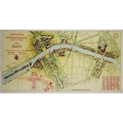
1937 original poster illustrated map of the Exposition Internationale
Located in PARIS, FR
This 1937 original poster presents a detailed illustrated map of the Exposition Internationale des Arts et Techniques dans la Vie Moderne, held in Paris. The International Exposition...
Category
1930s Prints and Multiples
Materials
Linen, Paper, Lithograph
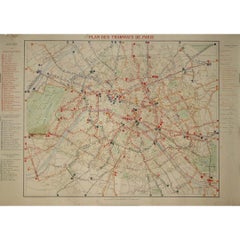
1899 "Plan des Tramways de Paris" by Wuhrer - Paris's public transportation
Located in PARIS, FR
The 1899 "Plan des Tramways de Paris" by Wuhrer is a fascinating snapshot of Paris's public transportation landscape at the dawn of the 20th century. This meticulously crafted map delineates the extensive network of tramway lines that crisscrossed the city, each route marked in detail to aid both residents and visitors in navigating the bustling metropolis.
The Belle Époque, during which this map was produced, was a period of significant growth and modernization in Paris. The city's population was expanding rapidly, and with it came the need for a more efficient means of urban transport. Tramways emerged as a vital solution, connecting neighborhoods and making the city's many attractions more accessible. These electric trams were a symbol of technological progress, replacing the horse-drawn carriages of earlier years and setting the stage for the future of public transit...
Category
1890s Prints and Multiples
Materials
Lithograph, Paper
1947 original map Gouvernement Généraux du Poitou, du Pays d'Aunis
Located in PARIS, FR
The 1947 original map Gouvernement Généraux du Poitou, du Pays d'Aunis et de Saintonge Angoumois, created by Louis Larmat and printed by Dorel in Paris, is a beautifully detailed cartographic representation of a historically significant region in western France. This map, part of Larmat’s extensive body of work, is known for its artistic craftsmanship and geographical precision, offering a comprehensive view of the historical administrative regions of Poitou, Aunis, Saintonge, and Angoumois, which played key roles in the political and cultural history of France.
Louis Larmat is celebrated for his contributions to cartography, particularly for his ability to merge historical context, topographical detail, and aesthetic elegance in his maps. His works, especially those focusing on the vinicultural regions of France, are highly respected for their accuracy and artistry. This particular map, although focusing on a more political and historical aspect rather than the wine regions he is most famous for, continues his tradition of detailed regional documentation. Larmat’s cartographic works often transcended the realm of simple geographical depiction, becoming historical documents that encapsulate the cultural essence of the regions they portray.
This map illustrates the general governments (administrative divisions) of the provinces of Poitou, Aunis, Saintonge, and Angoumois, regions that are steeped in history. These areas, situated along France’s western coastline, have been integral to the country’s political, economic, and cultural development over centuries. The region of Poitou, for example, is historically known as the birthplace of Eleanor of Aquitaine...
Category
1940s Prints and Multiples
Materials
Lithograph, Paper

You May Also Like
Paris and Surroundings – Antique Map by Gall and Inglis, Published 1843
Located in Langweer, NL
Antique Map of Paris and Environs by Gall and Inglis, 1843
This finely detailed map titled "Gall & Inglis’ Plan of Paris and Environs" was published in 1843 and provides a fascinati...
Category
Antique Mid-19th Century English Maps
Materials
Paper

Antique Map of the City of Berlin in Germany, '1847'
Located in Langweer, NL
Antique map titled 'Berlin'. Original antique map of the city of Berlin, Germany. This map originates from 'Abrégé de Géographie (..)' by Adrien Balbi. Published 1847.
Category
Antique Mid-19th Century Maps
Materials
Paper

$143 Sale Price
20% Off
Original Antique Map or City Plan of Madrid, Spain. Circa 1835
Located in St Annes, Lancashire
Nice map of Madrid
Drawn and engraved by J.Dower
Published by Orr & Smith. C.1835
Unframed.
Free shipping
Category
Antique 1830s English Maps
Materials
Paper

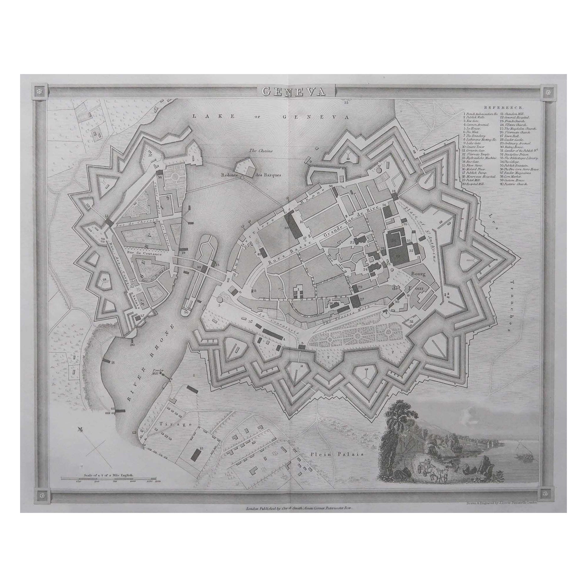
Original Antique Map or City Plan of Geneva, Switzerland. Circa 1835
Located in St Annes, Lancashire
Nice map of Geneva
Drawn and engraved by J.Dower
Published by Orr & Smith. C.1835
Unframed.
Free shipping
Category
Antique 1830s English Maps
Materials
Paper

Original Large Antique Map of Paris, France by John Dower, 1861
Located in St Annes, Lancashire
Fabulous monochrome map of Paris.
Vignettes of St Germain En Laye, Saint Cloud, Versailles and Fontainbleau.
Unframed.
Drawn by J.Dower.
Lithography by Weller. 4 sheets joined to...
Category
Antique 1860s English Victorian Maps
Materials
Paper

Antique Map of Paris, "Carte Routiere des Environs de Paris" 1841
Located in Colorado Springs, CO
This beautiful hand-colored road map of Paris was published in 1841. The map shows Paris and the surrounding area in a folding pocket map. Organized and detailed for travelers, this ...
Category
Antique 1840s French Maps
Materials
Paper
