Items Similar to Map of Nemavsus - Etching by George Braun - Late 16th Century

Want more images or videos?
Request additional images or videos from the seller
1 of 2
George BraunMap of Nemavsus - Etching by George Braun - Late 16th CenturyLate 16th Century
Late 16th Century
$352.50
£269.06
€300
CA$497.21
A$546.17
CHF 285.43
MX$6,513.51
NOK 3,614.33
SEK 3,367.05
DKK 2,286.58
About the Item
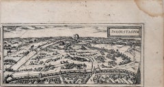
This Map of Nemavsus is an original etching realized by George Braun (1541 – 1622)
The state of preservation of the artwork is good and aged on the edges of the sheet with a few small pieces cut away.
Interesting B/W etching on coeval paper, this artwork represents skilfully a detailed view of the city of Nemavsus through confident strokes. At the top on the left side "NEMAVSUS ,NISMES, CIVITAS NAKBONENSIS GALLIA VETUSTISSIMA" printed.
The etching belongs to the collection "Civitates Orbis Terrarurm" realized by Georg Braun and Frans Hogenberg.
The Civitates Orbis Terrarum (Atlas of the Cities of the World) was the second oldest printed atlas in the history of world cartography and the first atlas totally dedicated to topographical views. The first volume of this collection was published in Cologne in 1572; the following in 1575, 1581, 1588, and 1598. The sixth and final volume appeared in 1617, shortly before the extensive devastation wreaked by the Thirty Years’ War.
This artwork is shipped from Italy. Under existing legislation, any artwork in Italy created over 70 years ago by an artist who has died requires a licence for export regardless of the work’s market price. The shipping may require additional handling days to require the licence according to the final destination of the artwork.
- Creator:George Braun
- Creation Year:Late 16th Century
- Dimensions:Height: 8.08 in (20.5 cm)Width: 10.24 in (26 cm)Depth: 0.04 in (1 mm)
- Medium:
- Period:
- Framing:Framing Options Available
- Condition:Insurance may be requested by customers as additional service, contact us for more information.
- Gallery Location:Roma, IT
- Reference Number:Seller: M-1087711stDibs: LU65036931322
About the Seller
4.9
Platinum Seller
Premium sellers with a 4.7+ rating and 24-hour response times
1stDibs seller since 2017
7,818 sales on 1stDibs
Typical response time: 1 hour
- ShippingRetrieving quote...Shipping from: Roma, Italy
- Return Policy
More From This Seller
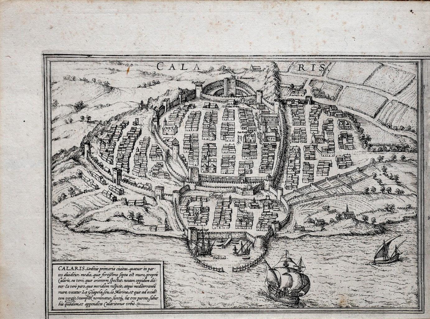
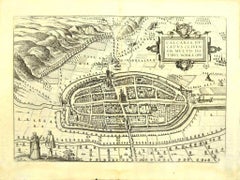
View AllAncient Map of Calaris - Etching by George Braun - Late 16th Century
Located in Roma, IT
Ancient Map of Calaris is an original etching belonging to the collection "Civitates Orbis Terrarurm" realized by Georg Braun and Frans Hogenberg.
The Civitates Orbis Terrarum (Atla...
Category
16th Century More Prints
Materials
Etching

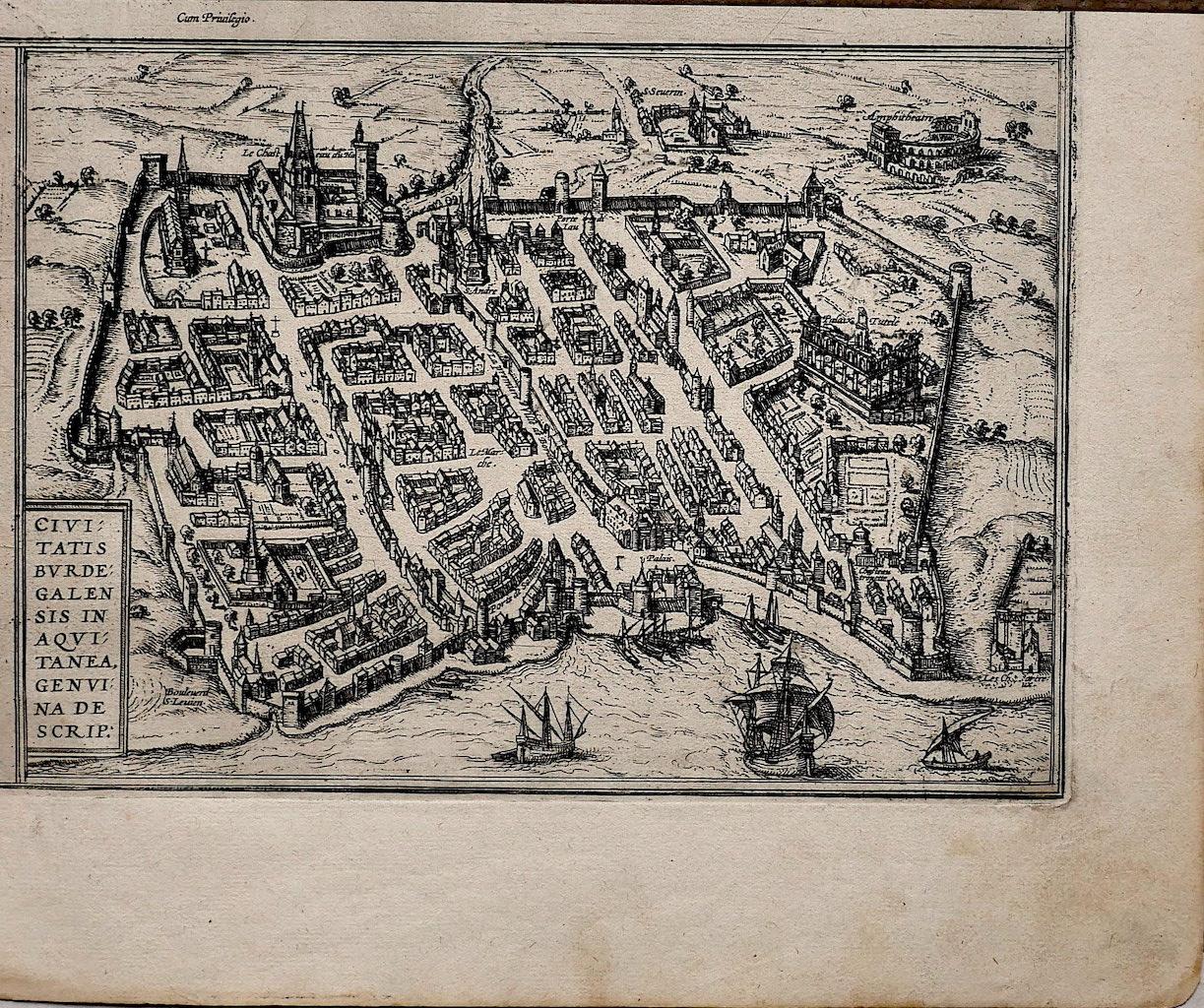
Map of Burdegalen - Original Etching by George Braun - 1575 ca.
Located in Roma, IT
This Burdegalen is an original etching realized in about 1575 by George Braun (1541 – 1622)
The state of preservation of the artwork is good and aged on the edges of the sheet with...
Category
16th Century More Prints
Materials
Etching

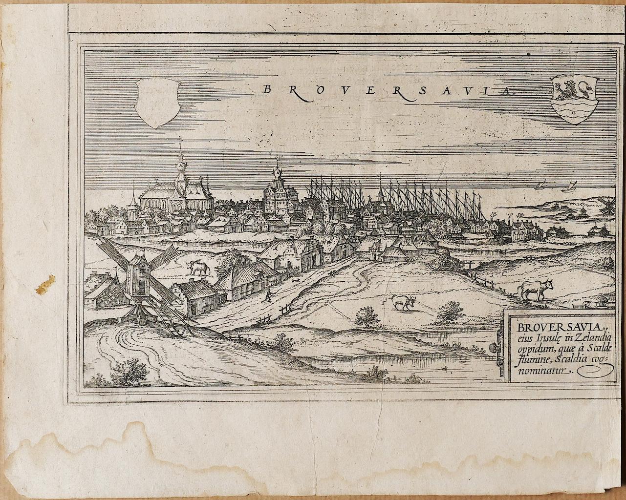
Map of Broversavia - Etching by George Braun - Late 16th Century
Located in Roma, IT
This Map of Broversavia is an original etching realized by George Braun (1541 – 1622)
The state of preservation of the artwork is good and aged on the edges of the sheet with a few...
Category
16th Century More Prints
Materials
Etching

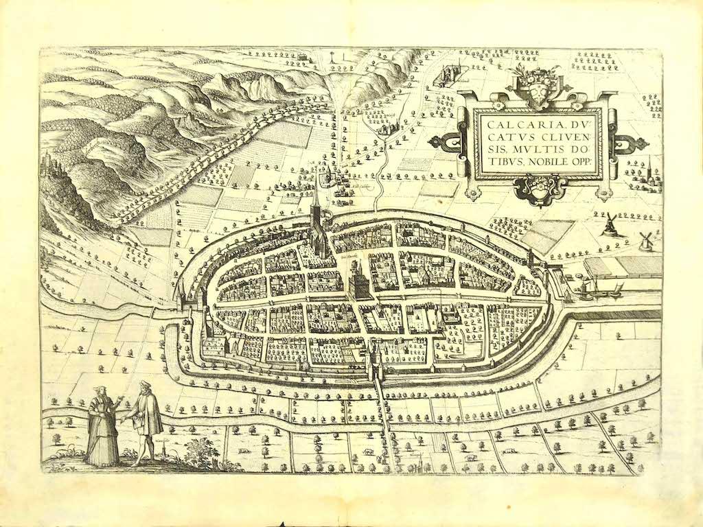
Map of Kalkar - Etching by G. Braun and F. Hogenberg - Late 16th Century
By Franz Hogenberg
Located in Roma, IT
This map of Calcaria is an original etching realized by George Braun and Franz Hogenberg, as part of the famous Series "Civitates Orbis Terrarum" (Atlas of the Cities of the World)....
Category
16th Century Figurative Prints
Materials
Etching
Map of Alhama - Etching by G. Braun and F. Hogenberg - Late 16th Century
By Franz Hogenberg
Located in Roma, IT
This map of Alhama de Granada is an original etching realized by G. Braun and F. Hogenberg, as part of the famous "Civitale Orbis Terrarum" (Atlas of the Cities of the World).
The...
Category
16th Century Figurative Prints
Materials
Etching
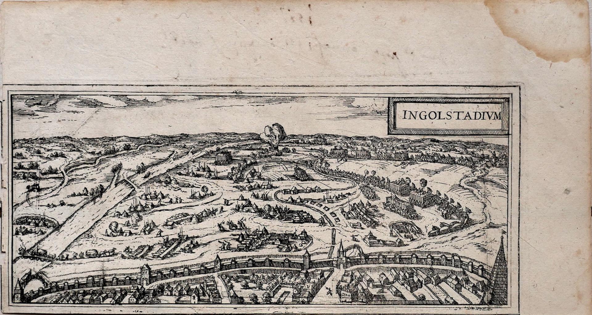
Map of Ingolstadt - Etching by George Braun- Late 16th Century
Located in Roma, IT
This Ingolstadium is an original etching realized by George Braun and Franz Hogenberg.
The state of preservation of the artwork is good but aged and at the top on the right angle yo...
Category
16th Century More Prints
Materials
Etching
You May Also Like
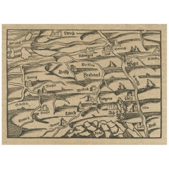
Rare 16th Century Woodcut Map of Brabant and the Rhine Valley, circa 1549
Located in Langweer, NL
Title: Rare 16th Century Woodcut Map of Brabant and the Rhine Valley, circa 1550
Description:
This rare and highly decorative early woodcut map depicts the region of Brabant and the...
Category
Antique 16th Century German Maps
Materials
Paper
16th c. woodcut map - Tabula Asiae Vlll
By Sebastian Münster
Located in Santa Monica, CA
SEBASTIAN MUNSTER (1488-1652)
ASIAE TABVLA Vlll 1540 (45)
Woodcut from Munster's edition of Geographia Universalis, Basel, Henri Petri. 1545 edit...
Category
16th Century Old Masters Landscape Prints
Materials
Woodcut

$950 Sale Price
29% Off
Antique Map of the Region of Grave by Orlers, 1615
Located in Langweer, NL
Antique map of the region of Grave, also including Cuijk and Ravestein. This map originates from 'La genealogie des illustres Comtes de Nassau' by Jan Jansz. Orlers.
Artists and E...
Category
Antique 17th Century Maps
Materials
Paper
Engraving Depicting 16th Century Map of Terra Sancta
Located in Buchanan, MI
Abraham Ortelius (Flemish, 1527-1598) Terra Sancta.
Engraving depicting 16th century map of Terra Sancta. Site 15" x 19.5.
Category
Antique 18th Century and Earlier Maps
Materials
Paper

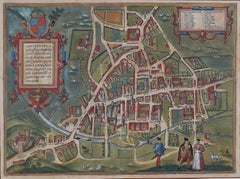
Map of Cambridge, c.1572 engraving by Braun & Hogenberg
Located in London, GB
To see our other views of Oxford and Cambridge, scroll down to "More from this Seller" and below it click on "See all from this Seller" - or send us a message if you cannot find the ...
Category
16th Century Realist Landscape Prints
Materials
Engraving
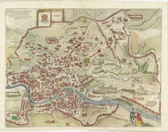
Rare 1572 Map of Ancient Rome with Monuments by Ligorio, Braun & Hogenberg
Located in Langweer, NL
Rare 1572 Map of Ancient Rome with Monuments by Ligorio, Braun & Hogenberg
This remarkable 16th-century map, *Urbis Romae Situs cum ils quae adhuc Conspiciuntur Veter. Monumet Rel...
Category
Antique 16th Century German Maps
Materials
Paper
More Ways To Browse
Antique Gallia
Lake Garda Vintage Poster
Lela Bliss
Lennon Woman
Levi Andy Warhol
Li Sheng
Libro Poster
Lifesaver Pop Art
Lizzie Riches
Lux Soap
Marcus Uzilevsky
Marino Marini Jongleur Et Chevaux
Maurin Green Devil
Musee Matisse Nice Vintage Poster
Naomi Limont
New Mexico Travel Posters
Nicolas De Poilly
Noel Fielding