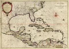
Caarte Van West Indien, Soo Vaste landen als Eylanden, ...
View Similar Items
Want more images or videos?
Request additional images or videos from the seller
1 of 9
Joan VingboonsCaarte Van West Indien, Soo Vaste landen als Eylanden, ... circa 1655 - 1700.
circa 1655 - 1700.
About the Item
- Creator:Joan Vingboons (1616 - 1670, Dutch)
- Creation Year:circa 1655 - 1700.
- Dimensions:Height: 22 in (55.88 cm)Width: 31 in (78.74 cm)Depth: 2 in (5.08 cm)
- Medium:
- Period:Late 17th Century
- Condition:Overall in good condition. Backed on linen. There is some running of the red pigment, which likely occurred when the linen was applied. There is some loss of paper due to verdigris in the western edge of Virginia. One split in the top which parallels.
- Gallery Location:New York, NY
- Reference Number:Seller: #325611stDibs: LU33121953923
About the Seller
4.6
Recognized Seller
These prestigious sellers are industry leaders and represent the highest echelon for item quality and design.
Established in 1898
1stDibs seller since 2015
50 sales on 1stDibs
Typical response time: 1 to 2 days
Associations
International Fine Print Dealers Association
More From This SellerView All
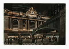
- Hidden Cities III : ContinuumBy Peter MiltonLocated in New York, NY“HIDDEN CITIES III : CONTINUUM” Contemporary artist Peter Milton created this etching and engraving in 2006. The printed image size is 24 x 37 inches and the paper size 32 x 45 inc...Category
21st Century and Contemporary Contemporary Figurative Prints
MaterialsEngraving, Etching
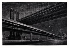
- Above the RushBy Frederick MershimerLocated in New York, NYFred Mershimer created "Above the Rush" in 2003 using mezzotint and aquatint printmaking techniques. The edition of 120 pieces is printed in color. It is signed, titled, and dated ...Category
21st Century and Contemporary American Realist Interior Prints
MaterialsMezzotint, Aquatint
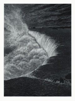
- NiagaraBy Frederick MershimerLocated in New York, NYNIAGARA Contemporary artist Frederick Mershimer created the mezzotint engraving entitled “Niagara” in 2021. This impression is signed, titled, dated, and inscribed “5/45”- the 5th ...Category
21st Century and Contemporary American Realist Landscape Prints
MaterialsMezzotint
- CrossingsBy Frederick MershimerLocated in New York, NYCROSSINGS Contemporary artist Frederick Mershimer created the mezzotint engraving entitled "Crossings" in 1998. This impression is signed, titled, and dated in pencil. The printed ...Category
Late 20th Century American Realist Landscape Prints
MaterialsMezzotint
- Indiarum Occidentalium Tractus Littorales cum Insulis Caribicis / Pascaert van WBy Louis RenardLocated in New York, NYThis early 18th-century engraved map was published by Louis Renard in Amsterdam. The image size is 19 x 22 " (48.3 x 55.9 cm) plus margins. A beautifully engraved Dutch sea chart. Shown is the entire Caribbean basin including the eastern seaboard up to Cape Cod and includes Bermuda. Florida is shown with the classic flattened southeastern coast that was derived by Hessel Gerritz. Noted are the routes taken by the Spanish treasure...Category
18th Century Other Art Style More Prints
MaterialsEngraving
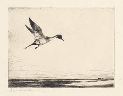
- Lone Pintail.By Frank BensonLocated in New York, NYThis drypoint from 1930 was printed in an edition of 150. It is signed in pencil just under the image in the lower left. Listed in the catalogue raisonne on Frank W. Benson by Adam Paff #303. Frank Weston Benson (1862-1951), well known for his American impressionist paintings, produced an incredible body of prints - etchings, drypoints, and a few lithographs. Born and raised on the North Shore of Massachusetts, Benson, a natural outdoorsman, grew up sailing, fishing, and hunting. While a teenager his fascination with drawing and birding developed simultaneously and continued throughout his life. His first art instruction was with Otto Grundman at the Museum of Fine Arts in Boston, and then in 1883 in Paris at the Academie Julian where he studied the rigorous ‘ecole des beaux arts’ approach to drawing and painting for two years. During the early 1880’s Seymour Haden visited Boston giving a series of lectures on etching. This introduction to the European etching...Category
1930s American Realist More Prints
MaterialsDrypoint

You May Also Like
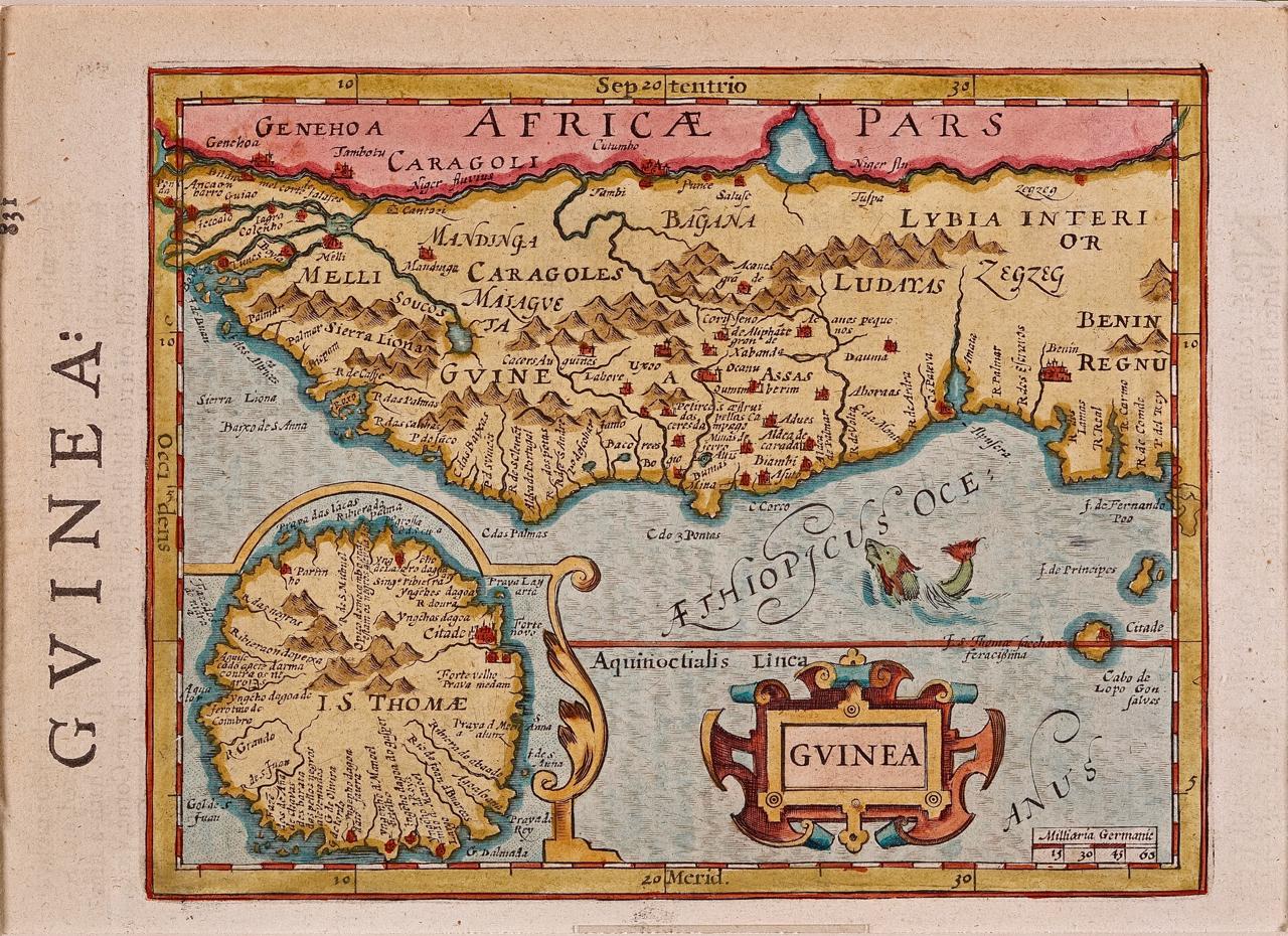
- West Africa: A 17th Century Hand-Colored Map by Mercator/HondiusBy Gerard MercatorLocated in Alamo, CAA 17th century hand-colored map entitled "Guineae Nova Descriptio" by Gerard Mercator and Jodocus Hondius, published in their 'Atlas Minor' in Amsterdam in 1635. It is focused on the...Category
1630s Landscape Prints
MaterialsEngraving
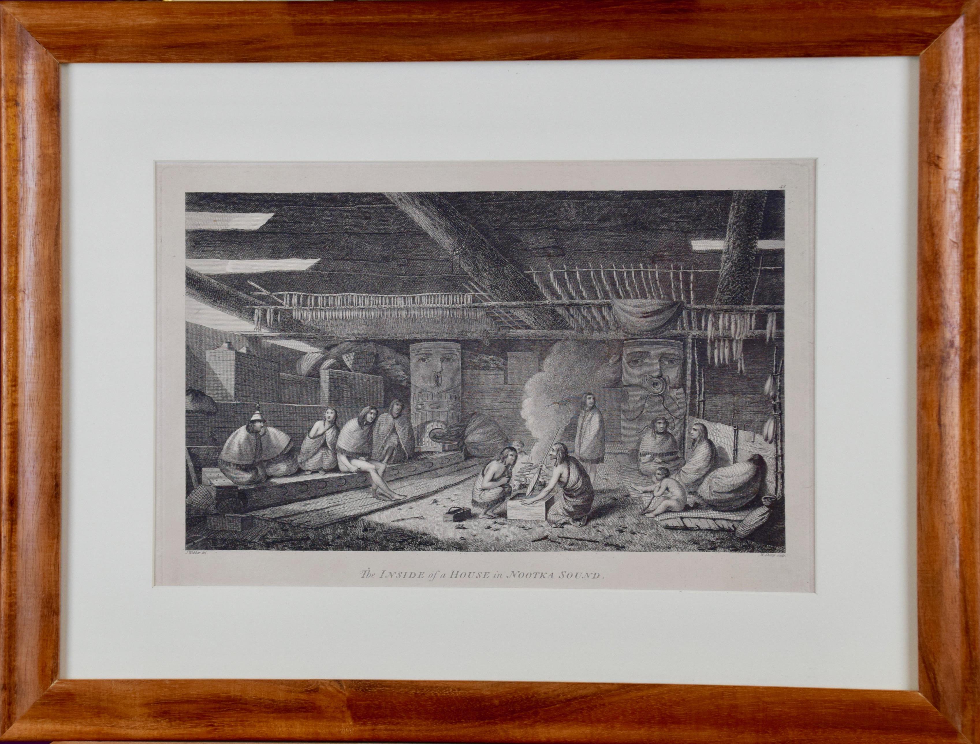
- "Inside of a House in Nootka Sound" (Canada) from Captain Cook's 3rd VoyageBy John WebberLocated in Alamo, CA"The Inside of a House in Nootka Sound" is an engraving created by William Sharp (1749-1824), from a drawing by John Webber (1752-1793), who was the artist on Captain James Cook's 3rd and final voyage of discovery. It is Plate 65 in "A Voyage to the Pacific Ocean Undertaken by the Command of His Majesty, for Making Discoveries in the Northern Hemisphere", the official British Admirality sanctioned journal published upon completion of the voyage in London in 1784 by Strahan & Cadell. This engraving is presented in a Koa wood frame and a white mat. There are occasional tiny faint spots, but the print is otherwise in very good condition. Koa wood is legendary in Hawaii. Not only is this amazing wood native to Hawaii, but it is known for the deep rich colors and varied grain pattern. Koa has an honored heritage in Hawaii and is highly revered and sacred. The word “koa” means “warrior” in Hawaiian. The warriors of King Kamehameha the Great, created canoes and weapons from a wood plentiful on the Big Island of Hawaii. This wood became synonymous with the warriors themselves, and it became known as koa. There are three other engravings listed form the official journal of Captain Cook's 3rd voyage available that are presented in identical Koa wood frames and mats. They would make a wonderful grouping for a display of 2, 3 or 4 prints. Please see listings: LU117324682432, LU117324684022, LU117324684062. A discount is available for a grouping depending on the number of items included. Nootka Sound is on the west coast of Vancouver Island, British Columbia, Canada. It was explored by Captain Cook in 1778 after he discovered Hawaii during his 3rd voyage. He originally named it King George's Sound, but did record Nootka Sound, which he thought was its native name. Hawaii was originally called The Sandwich Islands in honor of The Earl of...Category
1780s Realist Interior Prints
MaterialsEngraving
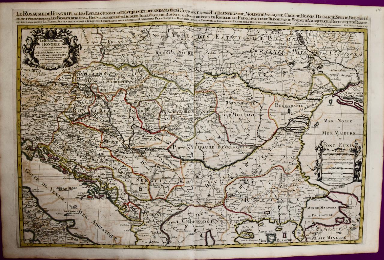
- Hungary & Eastern Europe: A Large 17th C. Hand-colored Map by Sanson & JaillotBy Nicholas Sanson d'AbbevilleLocated in Alamo, CAThis large hand-colored map entitled "Le Royaume De Hongrie et les Estats qui en ont este sujets et qui font presentement La Partie Septentrionale de la Turquie en Europe" was origin...Category
1690s Landscape Prints
MaterialsEngraving
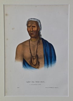
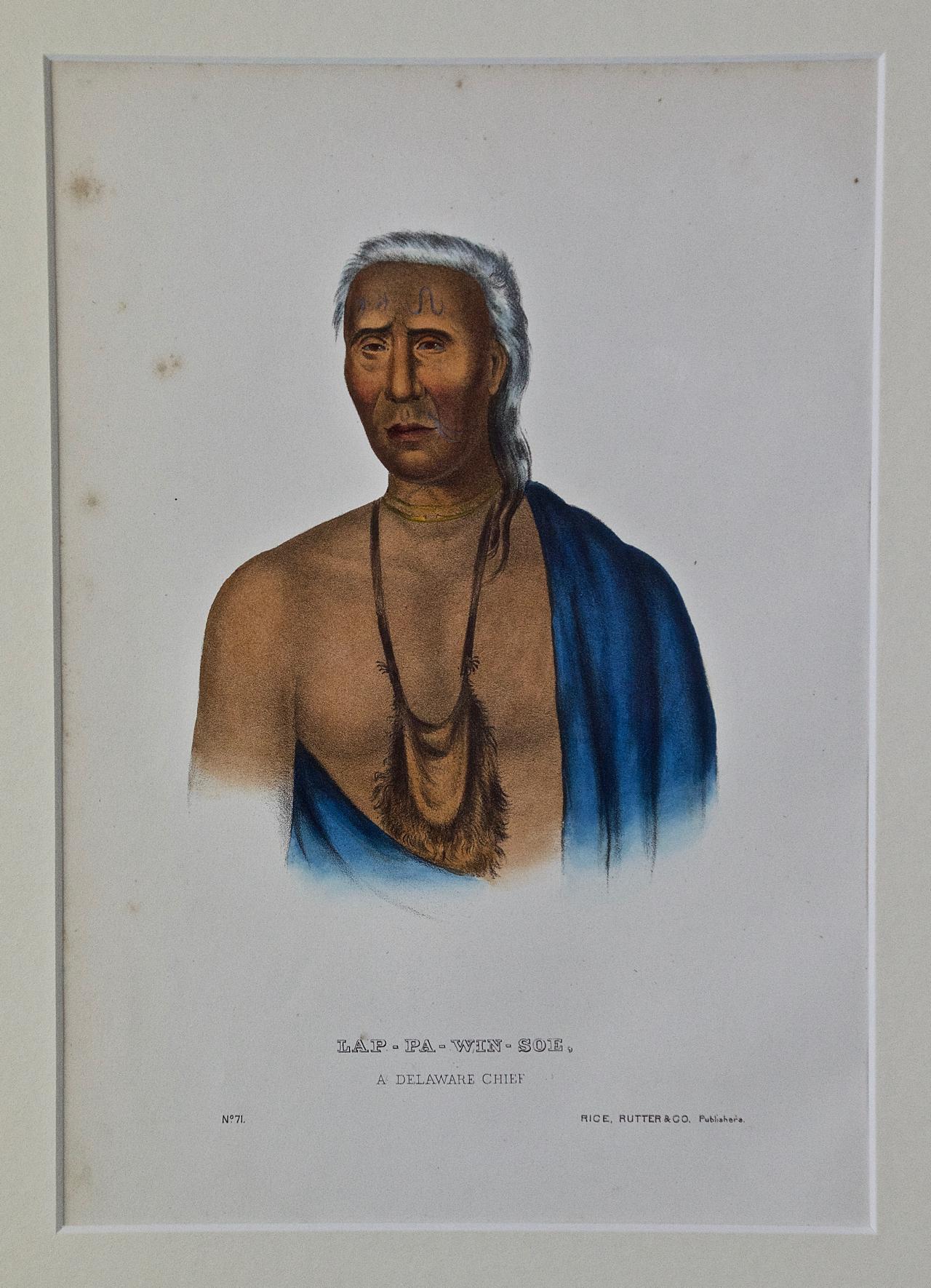
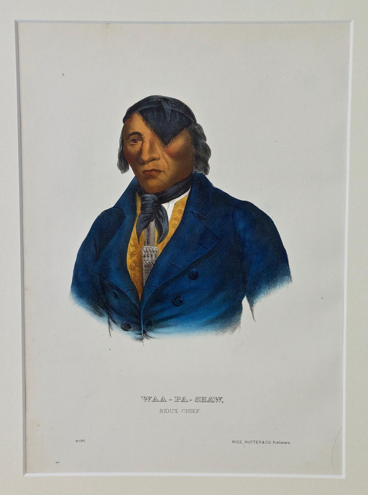
- Lap-Pa-Win-Soe, Delaware Chief: Original Hand-colored McKenney & Hall EngravingBy McKenney & HallLocated in Alamo, CAThis is an original 19th century hand-colored McKenney and Hall engraving of a Native American entitled "Lap-Pa-Win-Soe, A Delaware Chief, No. 71", published by Rice, Rutter & Co. in...Category
Mid-19th Century Naturalistic Portrait Prints
MaterialsEngraving
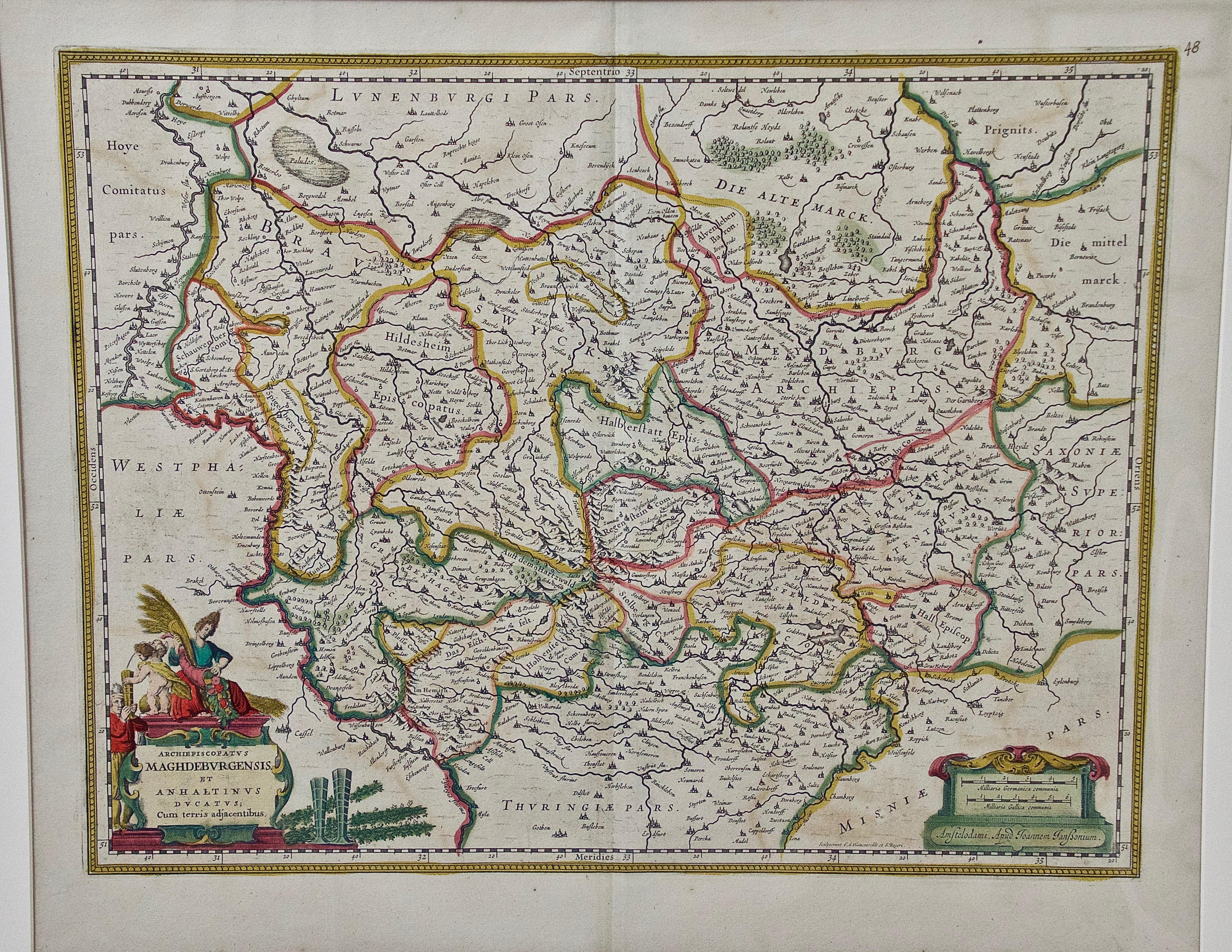
- West Germany: Original Hand Colored 17th Century Map by Johannes JanssoniusBy Johannes JanssoniusLocated in Alamo, CAAn original hand colored copperplate engraved map entitled in Latin "Archiepiscopatus Maghdeburgensis et Anhaltinus Ducatus cum terris adjacentibus", published in Amsterdam in 1640 i...Category
Mid-17th Century Old Masters More Prints
MaterialsEngraving
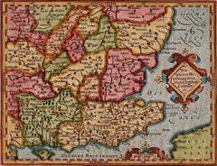
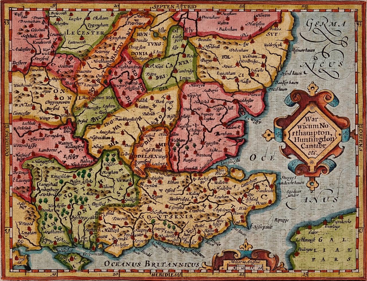
- Southeastern England: A 17th Century Hand-Colored Map by Mercator and HondiusBy Gerard MercatorLocated in Alamo, CAA 17th century copperplate hand-colored map entitled "The Sixt Table of England" by Gerard Mercator and Jodocus Hondius, published in Amsterdam in 1635 in 'Cosmographicall Descriptio...Category
1630s Landscape Prints
MaterialsEngraving