Items Similar to Original Vintage Illustrated Map Poster Union Of South Africa MacDonald Gill

Want more images or videos?
Request additional images or videos from the seller
1 of 7
"Leslie MacDonald ""Max"" Gill"Original Vintage Illustrated Map Poster Union Of South Africa MacDonald Gill1958
1958
About the Item
Original vintage illustrated map poster for the Union of South Africa - Philips pictorial map based upon original drawings by notable British graphic designer, cartographer, artist and architect Leslie MacDonald Gill (1884-1947) - Map features annotations of notable places, ports and industries with illustrations of agriculture, sheep, cattle, wheat, oranges, tobacco, pineapples and sugarcane. Precious commodities are also marked on the map using symbols including gold, diamonds, coal, iron, copper, uranium, platinum, asbestos and magnesium. The map is also decorated with a compass, coat of arms of South Africa, small map of England used to show scale, ships, waves and clouds. Printed by George Philip and Son LTD. Good condition, restored tears through image, restored paper losses on image, several restored crease marks on image, staining, foxing, backed on linen.
- Creator:
- Creation Year:1958
- Dimensions:Height: 33.08 in (84 cm)Width: 42.52 in (108 cm)
- Medium:
- Period:
- Condition:Good condition, restored tears through image, restored paper losses on image, several restored crease marks on image, staining, foxing, backed on linen.
- Gallery Location:London, GB
- Reference Number:1stDibs: LU43613412352
About the Seller
5.0
Platinum Seller
These expertly vetted sellers are 1stDibs' most experienced sellers and are rated highest by our customers.
Established in 2010
1stDibs seller since 2014
392 sales on 1stDibs
Typical response time: <1 hour
Associations
LAPADA - The Association of Arts & Antiques Dealers
- ShippingRetrieving quote...Ships From: London, United Kingdom
- Return PolicyA return for this item may be initiated within 3 days of delivery.
More From This SellerView All
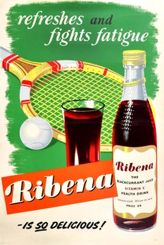
- Original Vintage Drink Poster For Ribena Refreshes Fights Fatigue Summer TennisLocated in London, GBOriginal vintage drink advertising poster - refreshes and fights fatigue Ribena is So Delicious - featuring a wooden tennis racquet / racket and ball on the grass behind a glass of R...Category
1950s More Prints
MaterialsPaper
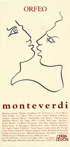
- Original Vintage Poster Orfeo Monteverdi Opera De Lyon Music Greek Legend ArtLocated in London, GBOriginal vintage advertising poster for the opera Orfeo written in 1607 by the notable Italian composer and priest Claudio Monteverdi (Claudio Giovanni Antonio Monteverdi; baptised 1...Category
1970s More Prints
MaterialsPaper
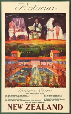
- Original Vintage Poster Rotorua New Zealand Nature Thermal Spa Health Blue BathsLocated in London, GBOriginal vintage travel poster advertising Rotorua Nature's Cure New Zealand Thermal Waters Health and Recreation featuring a colourful image of people swimming and relaxing at the R...Category
1930s More Prints
MaterialsPaper
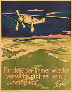
- Original Vintage Motivation Poster Nothing Is Impossible Unmoglich Doval QuoteLocated in London, GBOriginal vintage German motivational workplace poster issued by the Parker-Holladay company in Berlin featuring an illustration of a plane flying over the sea at night with the quote...Category
1920s More Prints
MaterialsPaper
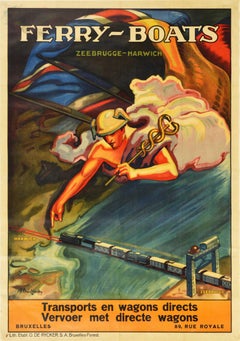
- Original Antique Poster Ferry Boats Zeebrugge Harwich Railway Travel TransportLocated in London, GBOriginal antique advertising poster - Ferry Boats Zeebrugge Harwich Transports en wagons directs Vervoer met directe wagons. Dynamic design featuring an anc...Category
1910s More Prints
MaterialsPaper
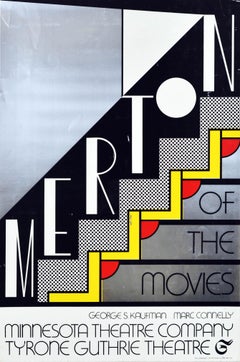
- Original Vintage Poster Merton Of The Movies Tyrone Guthrie Theatre Comedy PlayBy Roy LichtensteinLocated in London, GBOriginal vintage advertising poster for Merton of the Movies George S. Kaufman Marc Connelly Minnesota Theatre Company Tyrone Guthrie Theatre featuring a stunning design by the notab...Category
1960s More Prints
MaterialsPaper
You May Also Like
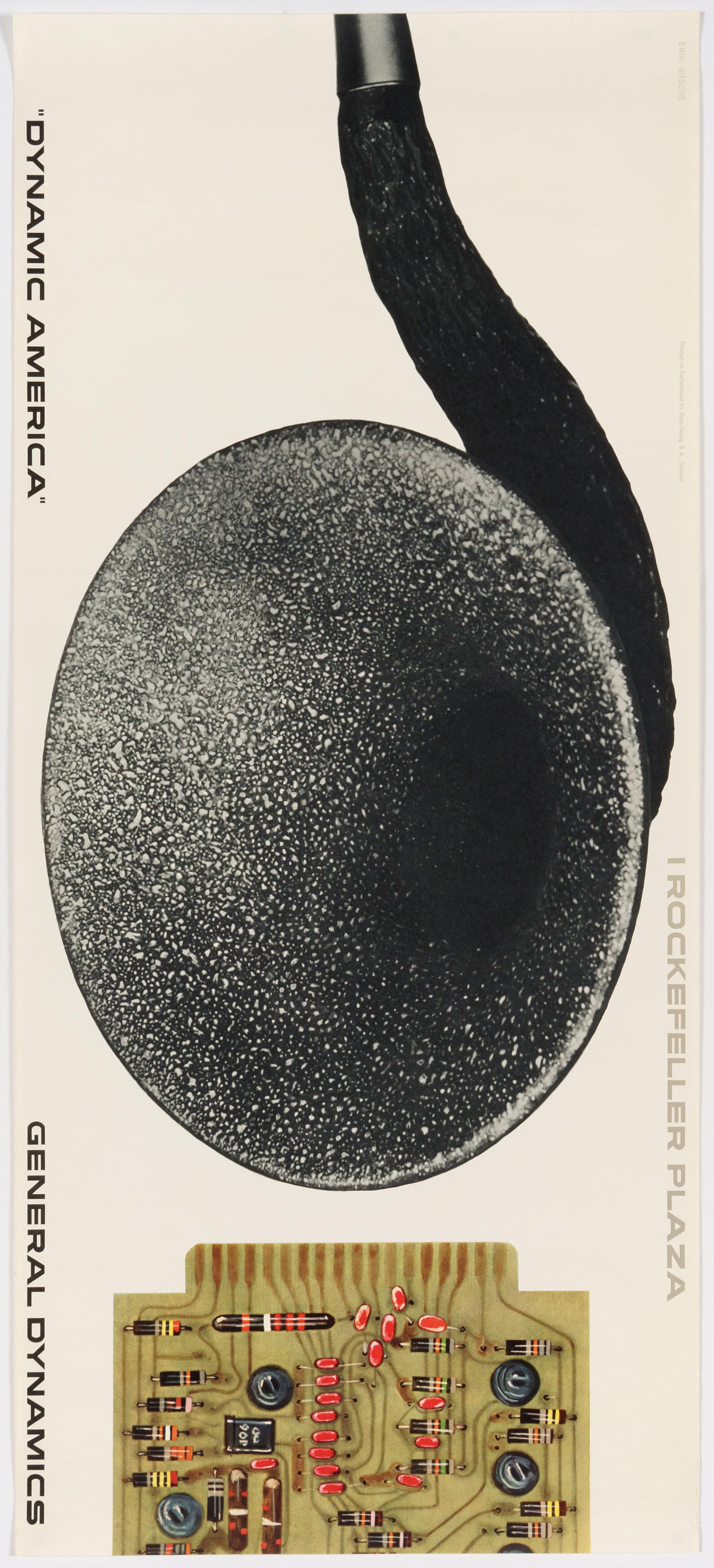
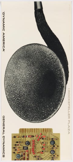
- General Dynamics, Exhibition Dynamic America, New York – Original Vintage PosterBy Erik NitscheLocated in Zurich, CHA poster by Erik Nitsche advertising General Dynamics' exhibition "Dynamic America" held 1961 in the newly renovated General Dynamics Building (formerly the Time-Life Building) at the Rockefeller Plaza in New York where the company promoted its achievements. The background to this poster is GD's division Stromberg-Carlson, a telecommunications equipment and electronics manufacturing company, founded 1895 in Chicago and acquired 1955 by General Dynamics (resold 1982). The two Swedish Immigrants started to improve Graham Bell...Category
Mid-20th Century Modern More Prints
MaterialsPaper
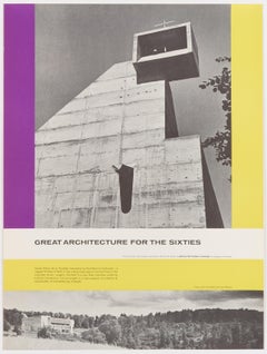
- Great Architecture for the Sixties – La Tourette by Le CorbusierBy Walter AllnerLocated in Zurich, CHOriginal Vintage Poster depicting Le Corbusier's Convent of La Tourette, published 1962 by the Architectural Forum to promote Modern Architecture –...Category
Mid-20th Century Modern More Prints
MaterialsPaper
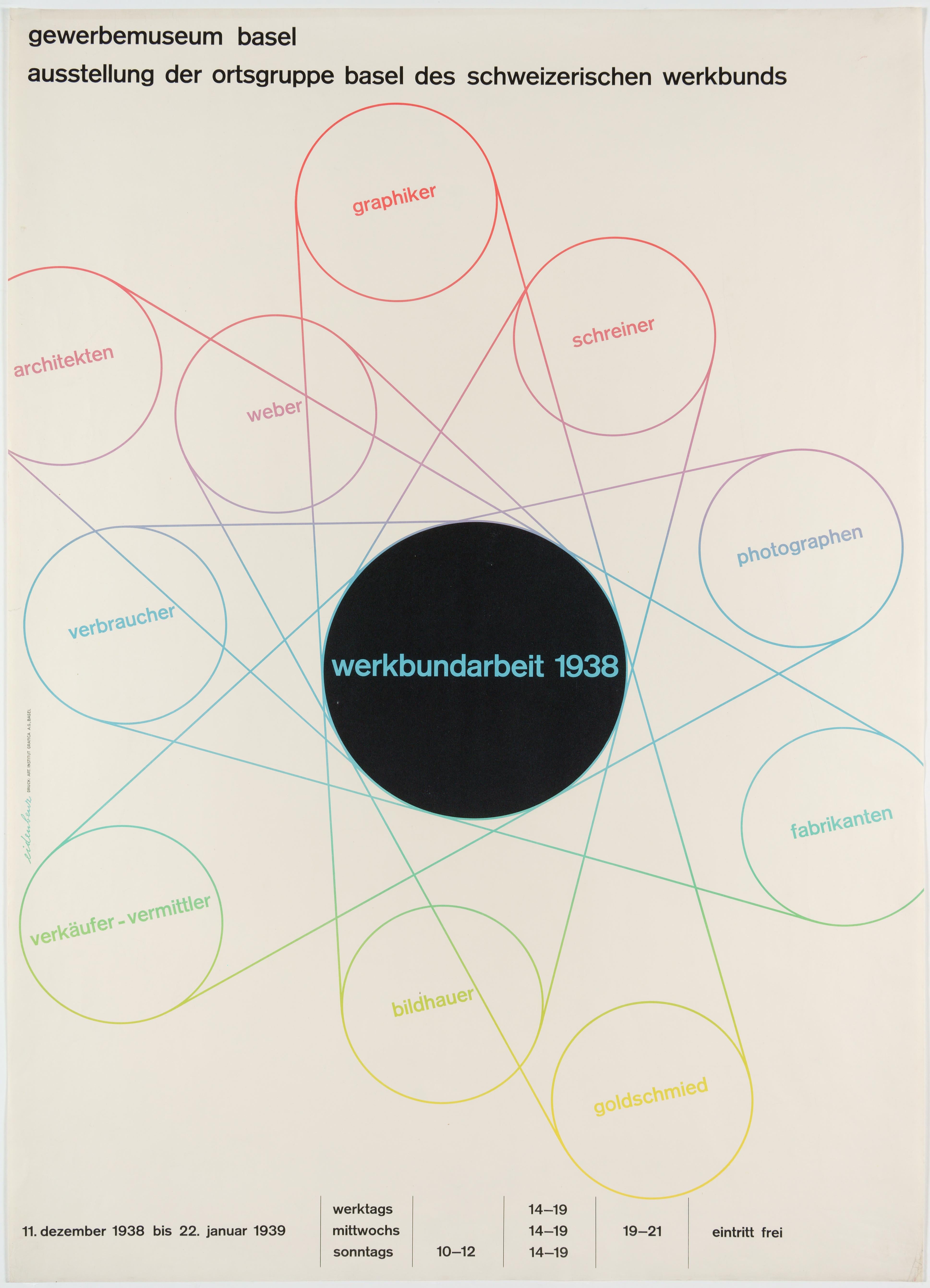
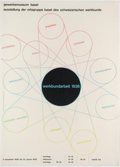
- Werkbund – Original Swiss Exhibition PosterLocated in Zurich, CHOriginal Swiss Exhibition poster by Hermann Eidenbenz (lithograph, printed by Art. Institut Grafica in Basel) advertising a show of the Basel section ...Category
1930s Modern Abstract Prints
MaterialsPaper
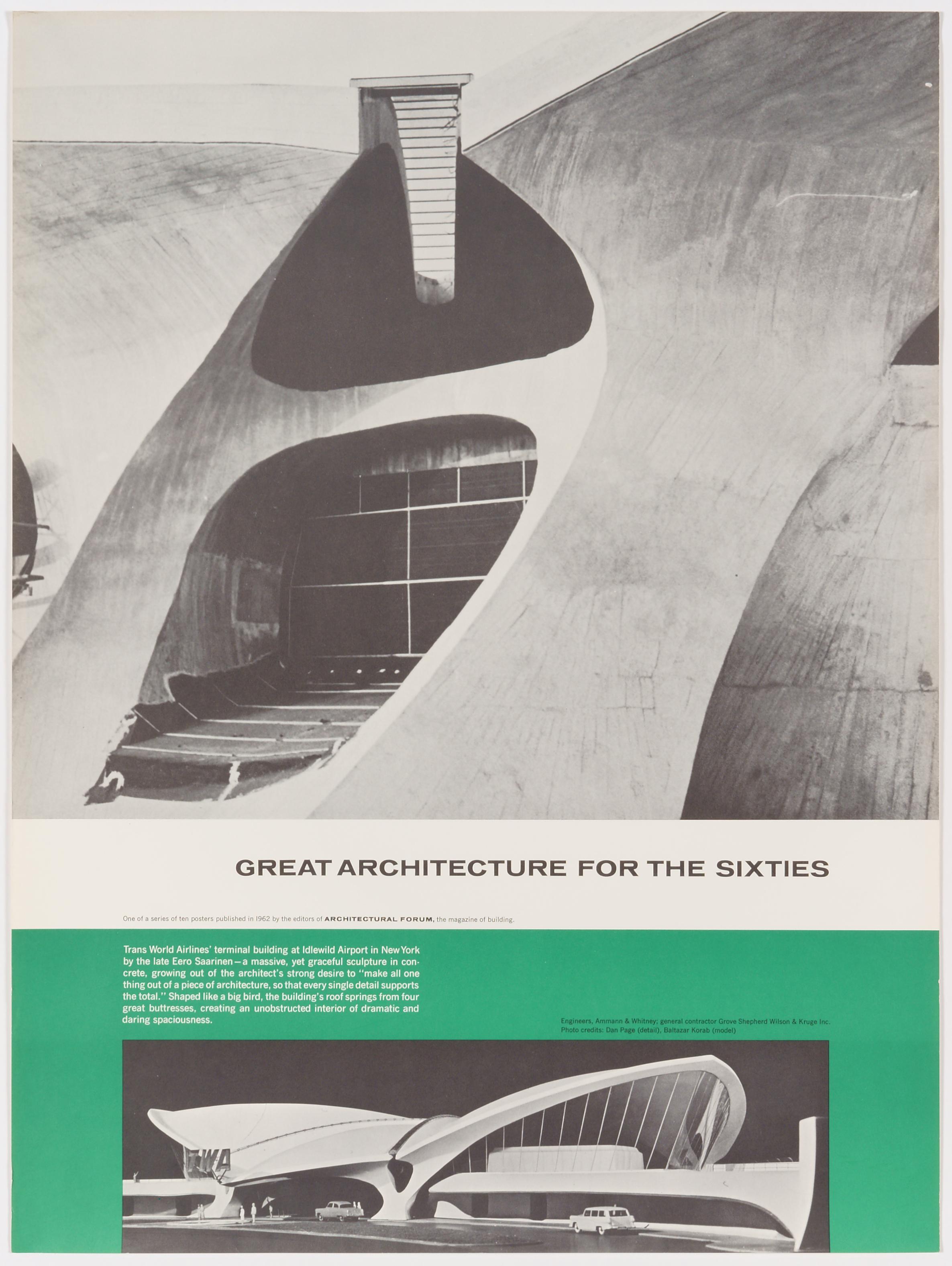
- Great Architecture for the Sixties – TWAs Terminal Building by Eero SaarinenBy Walter AllnerLocated in Zurich, CHOriginal Vintage Poster depicting Eero Saarinen's TWA Terminal, published 1962 by the magazine Architectural Forum to promote Modern Architecture – one of...Category
Mid-20th Century Modern More Prints
MaterialsPaper
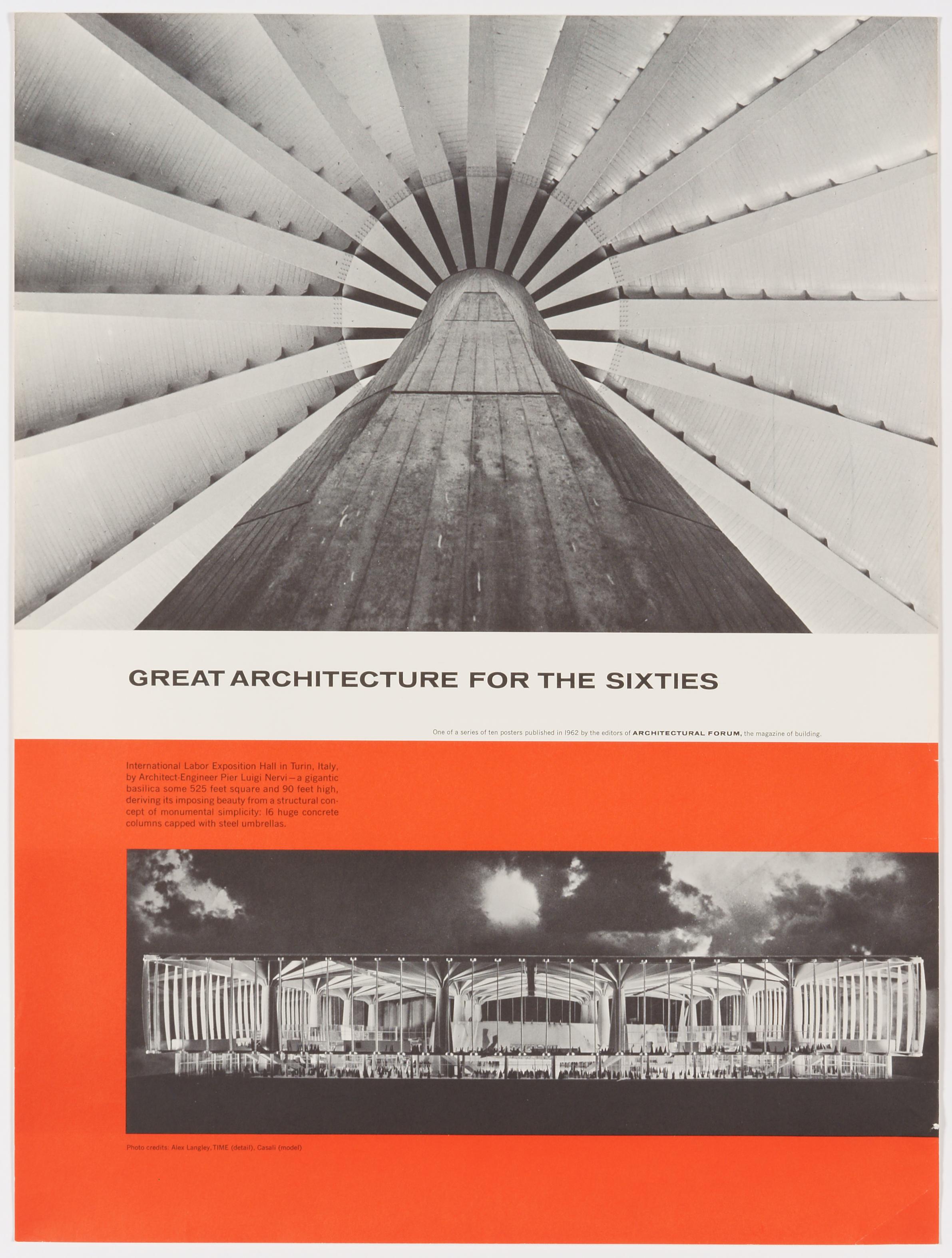
- Great Architecture for the Sixties – Pier Luigi Nervi's Exposition Hall in TurinBy Walter AllnerLocated in Zurich, CHOriginal Vintage Poster depicting Piero Luigi Nervi's International Labor Exposition Hall in Turin, published 1962 by the magazine Architectural Forum to p...Category
Mid-20th Century Modern More Prints
MaterialsPaper
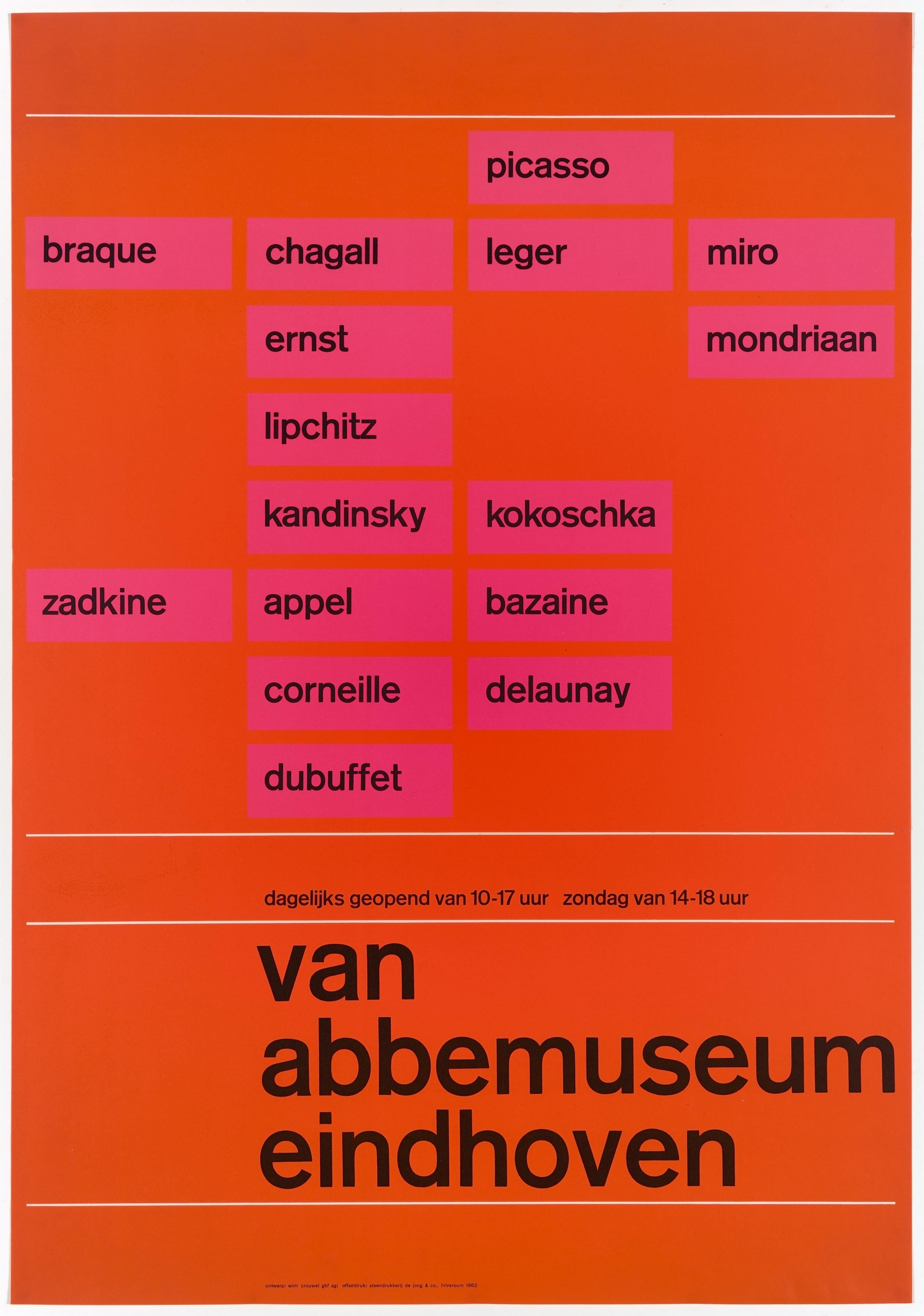
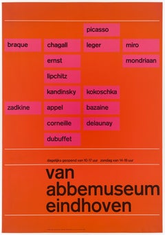
- Modern Art at the Van Abbemuseum in Eindhoven – Original Vintage Dutch PosterLocated in Zurich, CHOriginal Vintage Poster in bright and crisp colors by the Dutch graphic design legend Wim Crouwel, advertising rather the museum's collection of works by...Category
Mid-20th Century Abstract Abstract Prints
MaterialsPaper


Recently Viewed
View AllMore Ways To Browse
Copper Pineapple
Vintage Map South Africa
Vintage Maps Of England
Based Upon Ltd
Roseville Vista
Fontana Arte Shanghai
Vintage Yorkshire Map
David Shrigley Cat
David Shrigley Really Good
Percy Padden
Amsterdam Vintage Travel Poster
British Watercolor 1791
Running Athlete On Track
Retro Ski Posters Utah
Green Horizontal Art Print
Original Vintage Travel Posters Monte Carlo
Vintage Movie Posters South Pacific
Vintage Terrot French Poster