1780s More Prints
to
2
5
1
Overall Width
to
Overall Height
to
1
5
2
239
524
4,319
3,041
33
53
68
122
232
354
779
968
571
354
172
5
3
3
2
1
1
1
1
1
8
1
1
1
1
2
3
8
Period: 1780s
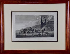
Sandwich Islands Canoe (Hawaii): Framed 18th C. Engraving Captain Cook's Journal
By John Webber
Located in Alamo, CA
"A Canoe of the Sandwich Islands, the Rowers Masked" is an engraving created by Charles Grignion, from a drawing by John Webber (1752-1793), who was the artist on Captain James Cook's 3rd and final voyage of discovery. It is Plate 65 in the atlas of "A Voyage to the Pacific Ocean Undertaken by the Command of His Majesty, for Making Discoveries in the Northern Hemisphere", the official British Admiralty sanctioned journal published upon completion of the voyage in London in 1784 by Strahan & Cadell.
This famous image of ten Hawaiian rowers transporting a priest who is carrying a feather-covered image of Kukailimoku, the Hawaiian god of war. The priests and paddlers are all wearing gourd masks in their double-hulled canoe with an upright lateen woven sail. Each hull was shaped from a single large Koa log harvested from island rainforests, where they were carved before being transported to the coast.
This engraving is presented in a Koa wood frame and a white mat. There are occasional faint spots, but the print is otherwise in very good condition. Koa is the same wood as was used to make the canoe. Koa wood is legendary in Hawaii. Not only is this amazing wood native to Hawaii, but it is known for the deep rich colors and varied grain pattern. Koa has an honored heritage in Hawaii and is highly revered and sacred. The word “koa” means “warrior” in Hawaiian. The warriors of King Kamehameha the Great, created canoes and weapons from a wood plentiful on the Big Island of Hawaii. This wood became synonymous with the warriors themselves, and it became known as koa. The frame measures 20.75" high, 26.75" wide and 0.88" deep.
There are three other engravings listed from the official journal of Captain Cook's 3rd voyage available that are presented in identical Koa wood frames and mat (LU117324682022, LU117324684052, LU117324684062). They would make a wonderful grouping for a display of 2, 3 or 4 prints. A discount is available for a grouping depending on the number of items included.
Hawaii was discovered by Captain Cook (1728-1779) during this voyage. Hawaii was originally called The Sandwich Islands in honor of The Earl of Sandwich...
Category
1780s More Prints
Materials
Engraving
"Inside of a House in Nootka Sound" (Canada) from Captain Cook's 3rd Voyage
By John Webber
Located in Alamo, CA
"The Inside of a House in Nootka Sound" is an engraving created by William Sharp (1749-1824), from a drawing by John Webber (1752-1793), who was the artist on Captain James Cook's 3rd and final voyage of discovery. It is Plate 65 in "A Voyage to the Pacific Ocean Undertaken by the Command of His Majesty, for Making Discoveries in the Northern Hemisphere", the official British Admirality sanctioned journal published upon completion of the voyage in London in 1784 by Strahan & Cadell.
This engraving is presented in a Koa wood frame and a white mat. There are occasional tiny faint spots, but the print is otherwise in very good condition. Koa wood is legendary in Hawaii. Not only is this amazing wood native to Hawaii, but it is known for the deep rich colors and varied grain pattern. Koa has an honored heritage in Hawaii and is highly revered and sacred. The word “koa” means “warrior” in Hawaiian. The warriors of King Kamehameha the Great, created canoes and weapons from a wood plentiful on the Big Island of Hawaii. This wood became synonymous with the warriors themselves, and it became known as koa.
There are three other engravings listed form the official journal of Captain Cook's 3rd voyage available that are presented in identical Koa wood frames and mats. They would make a wonderful grouping for a display of 2, 3 or 4 prints. Please see listings: LU117324682432, LU117324684022, LU117324684062. A discount is available for a grouping depending on the number of items included.
Nootka Sound is on the west coast of Vancouver Island, British Columbia, Canada. It was explored by Captain Cook in 1778 after he discovered Hawaii during his 3rd voyage. He originally named it King George's Sound, but did record Nootka Sound, which he thought was its native name. Hawaii was originally called The Sandwich Islands in honor of The Earl of...
Category
Realist 1780s More Prints
Materials
Engraving
White Stork "Ardea Ciconia": An 18th Century Hand-colored Engraving by Nozeman
Located in Alamo, CA
This is a rare 18th Century hand-colored large folio-sized copperplate engraving entitled "Ardea Ciconia" (White Stork) by Cornelius Nozeman in volume II of his publication 'Nederlan...
Category
Naturalistic 1780s More Prints
Materials
Engraving
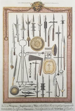
Various Weapons & Implements of War /// Edward Barnard's "History of England"
Located in Saint Augustine, FL
Artist: Edward Barnard (English, 1717-1781)
Title: "Various Weapons & Implements of War ... Which have been Employed Against the English, by Different Enemies: Now Deposited in the Tower of London"
Portfolio: New Complete and Authentic History of England
Circa: 1785
Medium: Original Hand-Colored Etching on laid paper
Limited edition: Unknown
Printer: Alex Hogg, London, UK
Publisher: Alex Hogg, London, UK
Sheet size: 15.38" x 9.63"
Image size: 11.75" x 7.94"
Condition: Slight toning to edges. Has been professionally stored away for decades. It is otherwise a strong impression in excellent condition
Notes:
Provenance: private collection - Cheltenham, UK. Engraved by English artist George Walker (1781-1856) after a drawing by English artist William Hamilton (1751-1801). Comes from Barnard's one volume "New Complete and Authentic History of England", (1783, 1785, 1790) (First - third editions), which consists of 105 engravings. Printed in one color from one copper plate: black.
Biography:
Edward Barnard (1717-1781) was an English cleric and academic, provost of Eton from 1764. Barnard was second son of Rev. George Barnard...
Category
Old Masters 1780s More Prints
Materials
Watercolor, Laid Paper, Engraving, Intaglio
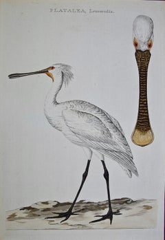
Spoonbill "Platalea leucorodia": An 18th Century Hand-colored Nozeman Engraving
Located in Alamo, CA
This a rare 18th century hand-colored large folio-sized copperplate engraving entitled "Platalea leucorodia" (Spoonbill) by Cornelius Nozeman in volume II of his publication 'Nederlandsche Vogelen', engraved by Christiaan Sepp or his son Jan Christiaan Sepp, published in Amsterdam in 1770. This engraving depicts a Platalea leucorodia Spoonbill, a large bird that lives mainly in Europe, Asia and Africa. It commonly migrates long distances on thermal air currents from the colder Northern European climates to Sub-Saharan Africa in the winter, sometimes as far long as Finland to South Africa. The Asian black stork...
Category
Naturalistic 1780s More Prints
Materials
Engraving
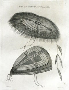
Caps of the Natives of Oonalashka (Alaska) Captain Cooks Voyage by John Webber
By John Webber
Located in Paonia, CO
Caps of the Natives of Oonalashka (Alaska) is from the 1784 First Edition Atlas Accompanying Capt. James Cook and King; Third and Final Voyage of Captain James Cook. John Webber (175...
Category
Realist 1780s More Prints
Materials
Engraving
A View at Bolcheretzko (Russia) 1784 Captains Cook Final Voyage by John Webber
By John Webber
Located in Paonia, CO
A View at Bolcheretzko (Russia) is from the 1784 First Edition Atlas Accompanying Capt. James Cook and King; Third and Final Voyage of Captain James Cook.John Webber (1752-1793) was ...
Category
Realist 1780s More Prints
Materials
Engraving
Kamtschatka, Russia: Engraving by J. Webber from Capt. Cook's 3rd Voyage Journal
By John Webber
Located in Alamo, CA
"A View of the Town and Harbour of St Peter and St Paul, in Kamtschatka" is an engraving created by Charles Grignion, from a drawing by John Webber (1752-1793), who was the artist on...
Category
1780s More Prints
Materials
Engraving
Related Items
Days Gone
Located in New Orleans, LA
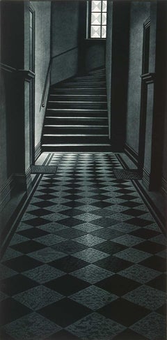
Finns always seek the solace of nature. Is this mysterious stairway an escape from the challenges of civilization? Vanttinen created this mezzotint in an edition of 100 and it is tit...
Category
Contemporary 1780s More Prints
Materials
Mezzotint
Before It Happened (A mysterious staircase offers no clues as to what happened)
Located in New Orleans, LA
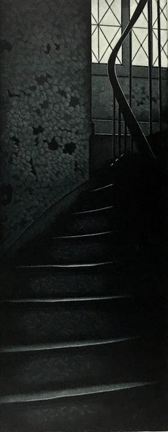
This Finnish artist creates a mezzotint in black and white. This impression is #44 of 100 and is signed, dated and titled in pencil.
Jukka Vanttinen (Finn, b. 1954)
Jukka Vanttinen...
Category
Modern 1780s More Prints
Materials
Mezzotint
Rocks, German antique geological microcopic chromolithograph print
Located in Melbourne, Victoria
'Gesteine'
(Rocks)
German chromolithograph, circa 1895.
240mm by 155mm (sheet)
Category
Naturalistic 1780s More Prints
Materials
Lithograph
Sun Valley original alpine skiing poster c. 1960s Idaho United States of America
Located in London, GB
To see our other original vintage travel posters, many of which have skiing subjects, scroll down to "More from this Seller" and below it click on "See all from this seller" - or sen...
Category
Realist 1780s More Prints
Materials
Lithograph
Frankfort, Germany: A 16th Century Hand-colored Map by Braun & Hogenberg
Located in Alamo, CA
This is a 16th century original hand-colored copperplate engraved map of Frankfort, Germany entitled "Francenbergum, vel ut alij Francoburgum Hassiae Opp" by Georg Braun & Franz Hogenberg, from their famous city atlas "Civitates Orbis Terrarum", published in Cologne, Germany in 1595.
This is an English translation of an excerpt from the original text in the atlas:
"Frankenberg or, according to others, Francoburgum, a town in Hesse. Charlemagne vested the town of Frankenberg with many freedoms and privileges, which it still enjoys to this day, and on account of its valiant and victorious soldiers awarded a signet, upon which there formerly appeared a golden castle with a tower, together with the letter F and a golden crown.
Frankenberg, seen here from the northeast, lies on a hill above the River Eder. The hillside is covered with fields neatly separated by bushes and fences. Soaring above the town is the massive Liebfrauenkirche, which was modelled on St Elizabeth's church in Marburg. The New Town was founded in 1335 at the foot of the hill (right) and merged with the Old Town as late as 1556. Frankenberg was founded by Conrad of Thuringia in 1233/34 to prevent the archbishops of Mainz from expanding their sphere of influence...
Category
Old Masters 1780s More Prints
Materials
Engraving
German Aircraft, original vintage Second World War poster
Located in London, GB
German Aircraft
Original vintage Second World War poster
Lithograph
51 x 71 cm
c.1941-1944
This original vintage poster, published in 1941, depicts a series of German aircraft,...
Category
Realist 1780s More Prints
Materials
Lithograph
Lafitte's Blacksmith House (a bar named for a pirate on Bourbon St, New Orleans)
Located in New Orleans, LA
Lafitte's Blacksmith Shop is a New Orleans landmark at 941 Bourbon St. Like most New Orleans legends, history of Lafitte's Blacksmith Shop is a gumbo of tru...
Category
Contemporary 1780s More Prints
Materials
Mezzotint, Aquatint
Dig for Victory over Want - World War II public information poster leaflet
Located in London, GB
To see our other original vintage public information posters, scroll down to "More from this Seller" and below it click on "See all from this Seller" - or send us a message if you ca...
Category
Realist 1780s More Prints
Materials
Lithograph
Cicadas, German antique natural history insect chromolithograph print
Located in Melbourne, Victoria
'Auslandische Cikaden'
(Foreign cicadas)
German chromolithograph, circa 1895.
240mm by 155mm (sheet)
Category
Naturalistic 1780s More Prints
Materials
Lithograph
Carte Particuliere Des Coste De Bretagne qui Comprend Morlaix
Located in Paonia, CO
Carte Particuliere Des Costes De Bretagne qui Comprend Morlaix, Saint Paul de Leon, les Sept Isles, et L’Isle. Faite par ordre Exprez Du Roy de France is from the collection of ch...
Category
1780s More Prints
Materials
Engraving
Map of the Russian Empire: An Original 18th Century Hand-colored Map by E. Bowen
Located in Alamo, CA
This is an original 18th century hand-colored map entitled "A New & Accurate Map of The Whole Russian Empire, As Contain'd Both In Europe and Asia, Drawn from Authentic Journals, Sur...
Category
Old Masters 1780s More Prints
Materials
Engraving
Crossings
Located in New York, NY
CROSSINGS
Contemporary artist Frederick Mershimer created the mezzotint engraving entitled "Crossings" in 1998. This impression is signed, titled, and dated in pencil. The printed ...
Category
American Realist 1780s More Prints
Materials
Mezzotint
Previously Available Items
Arabia Hand Painted Map Engraving From "New and Correct English Atlas"
By John Cary
Located in Houston, TX
Hand-painted map of the Arabian peninsula with detailed topography and major city locations. The map is framed in a gold metal frame with a white map. The engraving has the artist st...
Category
Naturalistic 1780s More Prints
Materials
Engraving
