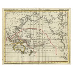
Items Similar to Ancient Map of Oceania - Original Etching - 19th century


Want more images or videos?
Request additional images or videos from the seller
1 of 5
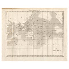
UnknownAncient Map of Oceania - Original Etching - 19th century19th Century
19th Century
$353.77
£268.98
€300
CA$496.27
A$542.21
CHF 285.17
MX$6,518.78
NOK 3,590.56
SEK 3,371.06
DKK 2,284.96
About the Item
This Map of Oceania is an etching realized in the 19th century.
The state of preservation of the artwork is good. At the top of the paper, the inscription “Longitudine del Meridiano dell'Isola del Ferro”, whilst at the bottom on the right, just above the border, the inscription “Longitudine O. di Parigi”. In addition at the bottom on the left the inscription “Longitudine E. di Parigi” and At the top right, the number of the sheet "Tav.31 is printed.
- Creation Year:19th Century
- Dimensions:Height: 10.44 in (26.5 cm)Width: 12.01 in (30.5 cm)Depth: 0.04 in (1 mm)
- Medium:
- Period:
- Framing:Framing Options Available
- Condition:Insurance may be requested by customers as additional service, contact us for more information.
- Gallery Location:Roma, IT
- Reference Number:Seller: M-1087561stDibs: LU65036930482
About the Seller
4.9
Platinum Seller
Premium sellers with a 4.7+ rating and 24-hour response times
1stDibs seller since 2017
7,793 sales on 1stDibs
Typical response time: 1 hour
- ShippingRetrieving quote...Shipping from: Roma, Italy
- Return Policy
Authenticity Guarantee
In the unlikely event there’s an issue with an item’s authenticity, contact us within 1 year for a full refund. DetailsMoney-Back Guarantee
If your item is not as described, is damaged in transit, or does not arrive, contact us within 7 days for a full refund. Details24-Hour Cancellation
You have a 24-hour grace period in which to reconsider your purchase, with no questions asked.Vetted Professional Sellers
Our world-class sellers must adhere to strict standards for service and quality, maintaining the integrity of our listings.Price-Match Guarantee
If you find that a seller listed the same item for a lower price elsewhere, we’ll match it.Trusted Global Delivery
Our best-in-class carrier network provides specialized shipping options worldwide, including custom delivery.More From This Seller
View AllMap of the World - Original Etching - 1820
Located in Roma, IT
Map of the World is an Original Etching realized by an unknown artist of 19th century in 1820.
Very good condition on two sheets of white paper joine...
Category
1820s Modern Figurative Prints
Materials
Etching

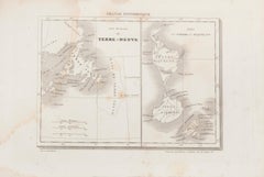
Map of Terre Neuve - Original Etching - 19th Century
Located in Roma, IT
Map of Terre Neuve is an original etching realized by an anonymous engraver of the XIX century.
Printed in series of "France Pittoresque" at the top center.
The state of preservati...
Category
19th Century Figurative Prints
Materials
Etching
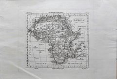
Map of Africa - Original Etching by C. Brue - 1820
Located in Roma, IT
Map of Africa is an original etching realized by C.Brue in 1820.
The print comes from the Series "Atlas Universal" PL. 31.
The state of preservation of the artwork is good except f...
Category
1820s Modern Figurative Prints
Materials
Etching

Ancient Map of Senegal - Original Etching - 19th Century
Located in Roma, IT
Map of Senegal is an original etching realized by an anonymous engraver of the 19th Century.
Printed in series of "France Pittoresque" at the top center.
The state of preservation ...
Category
19th Century Figurative Prints
Materials
Etching

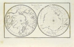
Map of Polar Regions - Original Etching - Late 19th Century
Located in Roma, IT
This Map of Polar regions is an etching realized by an anonymous artist.
The state of preservation of the artwork is good with some small diffused stains.
Sheet dimension: 28.5 x 4...
Category
Late 19th Century Modern Figurative Prints
Materials
Etching
Ancient Map of Africa - Etching - 19th century
Located in Roma, IT
This Map of Africa is an etching realized in the 19th century.
The state of preservation of the artwork is good. At the top of the paper, the inscription “Longitudine del Meridiano ...
Category
19th Century More Prints
Materials
Etching
You May Also Like
Antique Map of Oceania by Balbi '1847'
Located in Langweer, NL
Antique map titled 'Océanie'. Original antique map of Oceania. This map originates from 'Abrégé de Géographie (..)' by Adrien Balbi. Published 1847.
Category
Antique Mid-19th Century Maps
Materials
Paper

$141 Sale Price
20% Off
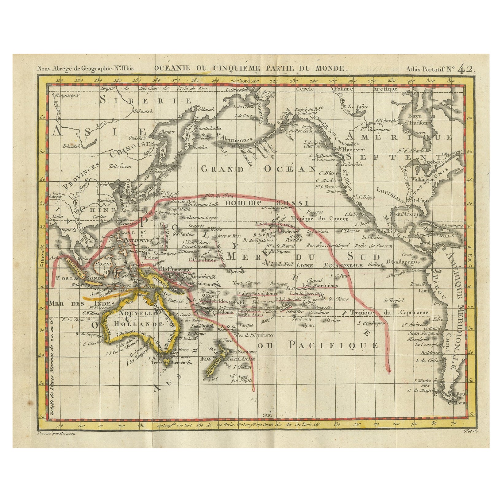
Antique Map of Oceania by Hérisson, 1816
Located in Langweer, NL
Antique map titled "Océanie ou cinquième partie du monde". This is an original antique map of Oceania, the 5th continent, by Herisson taken from atlas "Nouv. Abrége de Géographie". A...
Category
Antique 19th Century Maps
Materials
Paper

$120 Sale Price
20% Off
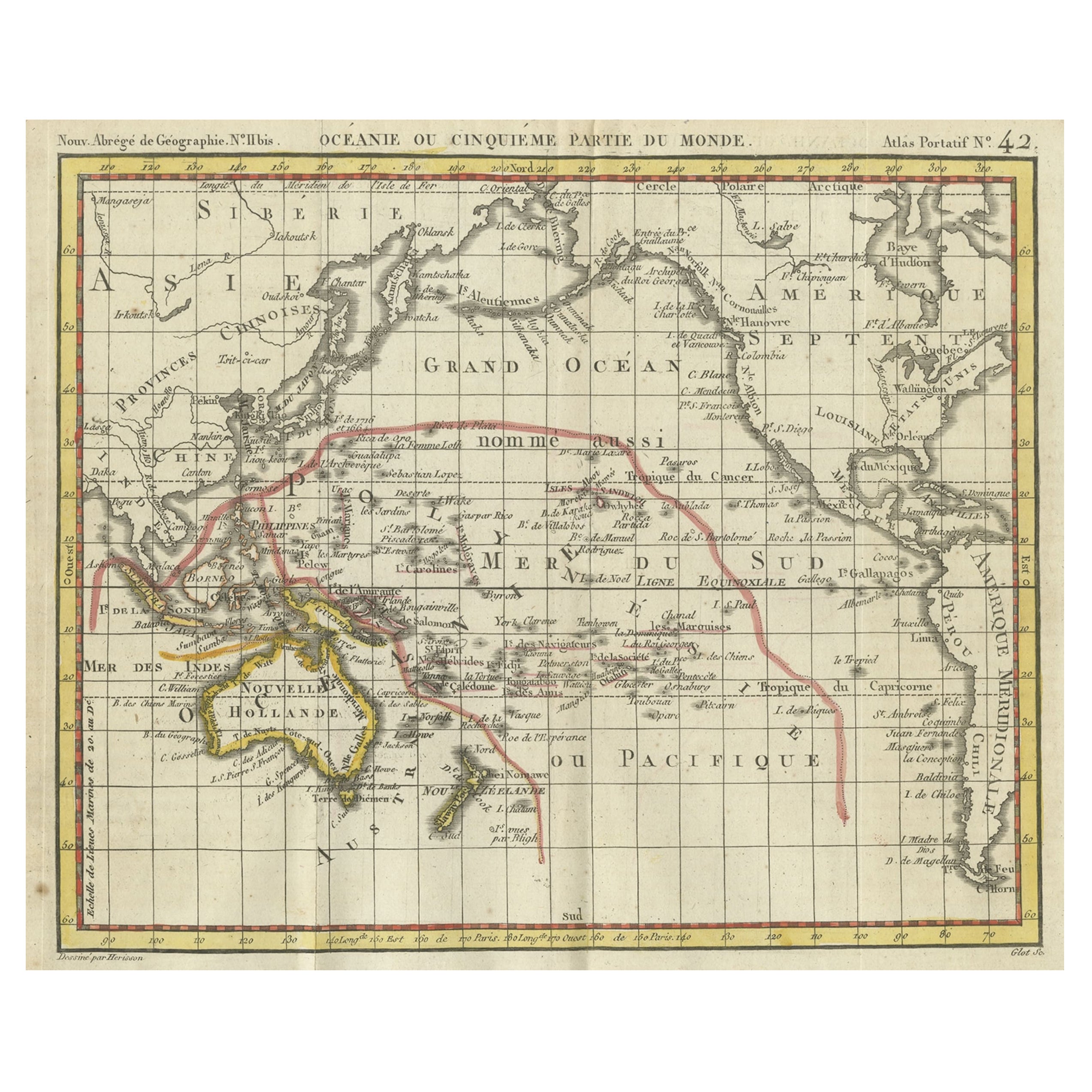
Original Antique Map of Oceania, the 5th Continent, 1816
Located in Langweer, NL
Antique map titled ‘Océanie ou cinquième partie du monde‘.
This is an original antique map of Oceania, the 5th continent, by Herisson taken from atlas "Nouv. Abrége de Géographie...
Category
Antique 1810s Maps
Materials
Paper
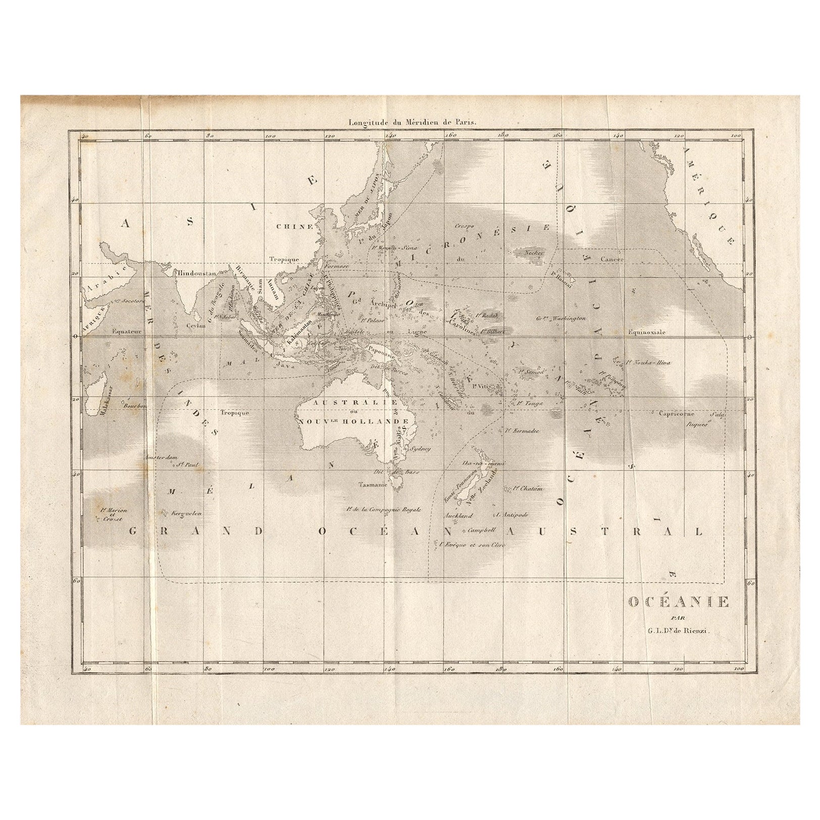
Antique Map of Oceania by Didot, 1836
Located in Langweer, NL
Antique map titled 'Oceanie par G.L.Dy. De Rienzi'. Map of the Oceania region, around Australia. This print originates from M.G.L. Domeny de Rienzi's 'Oceanie, ou Cinquieme Partie du...
Category
Antique 19th Century Maps
Materials
Paper
$83 Sale Price
20% Off
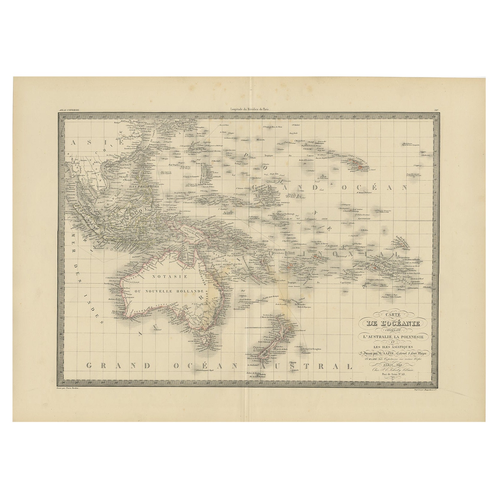
Antique Map of Oceania by Lapie, 1842
Located in Langweer, NL
Antique map titled 'Carte de l'Océanie contenant l'Australie, la Polynesie et les Iles Asiatiques'. Map of Oceania including Australia, Polynesia and several islands of Asia. This ma...
Category
Antique 19th Century Maps
Materials
Paper
$245 Sale Price
20% Off
Mid-19th Century Map of Australasia by Carl Flemming - 1855
Located in Langweer, NL
Title: "Mid-19th Century Map of Australasia by Carl Flemming - 1855"
Description: This original 1855 antique map from the Sohr-Berghaus Atlas, created by Carl Flemming, is a detaile...
Category
Antique 1850s Maps
Materials
Paper

More Ways To Browse
Ancient Maps
Lake Garda Vintage Poster
Lela Bliss
Lennon Woman
Levi Andy Warhol
Li Sheng
Libro Poster
Lifesaver Pop Art
Lizzie Riches
Lux Soap
Marcus Uzilevsky
Marino Marini Jongleur Et Chevaux
Maurin Green Devil
Musee Matisse Nice Vintage Poster
Naomi Limont
New Mexico Travel Posters
Nicolas De Poilly
Noel Fielding