Beers Atlas Co. Folk Art
to
1
1
1
1
1
1
1
1
1
1
1
1
185
139
101
84
Creator: Beers Atlas Co.
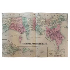
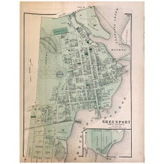
Antique Map Long Island, Southold, Shelter Island, Orient, New York
By Beers Atlas Co.
Located in Sag Harbor, NY
Antique map of Long Island, Southold, Shelter Island, Orient, Great details, Names of homes, Roads and Businesses in 1870. Unframed. This is...
Category
Mid-19th Century American Early Victorian Antique Beers Atlas Co. Folk Art
Materials
Paper
$1,180 Sale Price
20% Off
Related Items
Antique Map of the Island of Tahiti, Polynesia, 1803
Located in Langweer, NL
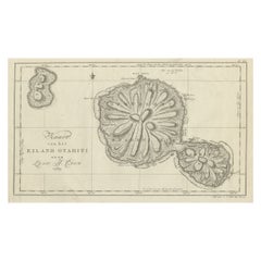
Antique map Tahiti titled 'Kaart van het Eiland Otahiti'.
Antique map of the Island of Tahiti, Polynesia. Originates from 'Reizen Rondom de Waereld door James Cook (..)'.
Artists...
Category
Early 1800s Dutch Antique Beers Atlas Co. Folk Art
Materials
Paper
$526 Sale Price
50% Off
H 11.42 in W 18.51 in D 0 in
Antique Map of North America with Vignette of the Statue of Liberty, New York
Located in Langweer, NL
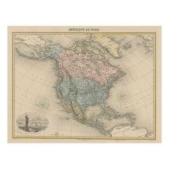
Antique map titled 'Amérique du Nord'. Original antique map of North America. Meticulous information from the new Alaska Territory and through the Caribbean Windward Islands. Very go...
Category
Late 19th Century Antique Beers Atlas Co. Folk Art
Materials
Paper
$435 Sale Price
20% Off
H 15.44 in W 20.4 in D 0.02 in
Antique Map of New Jersey
Located in Langweer, NL
Antique map titled 'Colton's New Jersey'. This rare hand colored map of New Jersey is a copper plate engraving dating to 1855. Produced by the import...
Category
Mid-19th Century Antique Beers Atlas Co. Folk Art
Materials
Paper
The Brooklyn Bridge Over the East River, Between Long Island and New York, 1883
Located in Langweer, NL
The Brooklyn Bridge Over the East River, Between Long Island and New York
Published in The Illustrated London News, June 1883.
The engraving from The Illustrated London News, is from June 1883, shortly after the bridge's completion. The Brooklyn Bridge was completed and opened to the public in May 1883, and engravings and illustrations like this one typically followed soon after its opening.
Description:
This hand-colored engraving, published in June 1883 in The Illustrated London News, commemorates the completion of the Brooklyn Bridge, which opened in May 1883. It captures the newly finished bridge spanning the East River, linking Long Island (Brooklyn) to Manhattan, New York City. The detailed panorama shows the urban landscape with buildings and streets leading to the grand suspension bridge, symbolizing one of the greatest engineering feats of the 19th century.
The bridge's enormous stone towers and suspension cables dominate the skyline, with a picturesque twilight sky framing the background. The engraving emphasizes the bustling waterfront, teeming with ships and ferries, highlighting the role of New York's waterways in commerce and transportation. The scene offers a glimpse into New York's rapidly growing cityscape, depicted with remarkable clarity from a rooftop perspective.
The caption below the engraving reads: The Brooklyn Bridge Over the East River, Between Long Island and New York.
This print, issued in *The Illustrated London News*, reflects the magazine’s dedication to visually documenting historic achievements in architecture and engineering.
---
**About the Publication and Technique:**
*The Illustrated London News*, founded in 1842, was the first illustrated weekly news magazine. Its pages were filled with engravings and illustrations that provided readers with vivid, detailed imagery of major events and landmarks from around the world. In the 19th century, the publication became known for its depictions of architectural and engineering triumphs, like the Brooklyn Bridge.
The engraving was produced using the wood engraving technique, in which artisans carved intricate designs into woodblocks, allowing for mass reproduction in magazines. This specific print is hand-colored, adding a vibrant, artistic quality to the precise wood engraving.
Keywords: Brooklyn Bridge June 1883, Brooklyn Bridge opening engraving, Illustrated London News Brooklyn Bridge, 19th-century New York illustrations...
Category
1880s Antique Beers Atlas Co. Folk Art
Materials
Paper
$208 Sale Price
20% Off
H 11.62 in W 15.95 in D 0 in
Antique Map of New York by Johnson '1872'
Located in Langweer, NL
Antique map titled 'Johnson's New York'. Original map showing New York, with an inset map of Long Island. This map originates from 'Johnson's New Il...
Category
Late 19th Century Antique Beers Atlas Co. Folk Art
Materials
Paper
Original Antique Map of the Cape Verde Islands, 1746
Located in Langweer, NL
Antique map titled 'Carte Des Isles Du Cap Verd.' Original antique map of the Cape Verde Islands. Decorative cartouche and compass rose. Extends from Isle d...
Category
18th Century Antique Beers Atlas Co. Folk Art
Materials
Paper
$161 Sale Price
20% Off
H 10.04 in W 14.57 in D 0 in
Antique Map of Scotland With an Inset Map of the Shetland Islands, 1854
Located in Langweer, NL
Stunning Map of Scotland that will look beautiful in any setting framed on the wall.
Description: Large Antique map titled 'Scotland with its Islands, drawn from the Topographical surveys...
Category
1850s Antique Beers Atlas Co. Folk Art
Materials
Paper
$1,183 Sale Price
20% Off
H 31.19 in W 22.92 in D 0 in
Antique Map of Japan, the Kurile Islands and Liu Kiu Islands, 1886
Located in Langweer, NL
The map is an exquisite piece, showcasing Japan's vibrant geography. Engraved by J. Bartholomew and published by George Philip & Son in London & Liverpool, it presents a detailed and...
Category
Late 19th Century Antique Beers Atlas Co. Folk Art
Materials
Paper
$142
H 18.43 in W 13.39 in D 0.02 in
Antique Map of New Ireland Island in the Bismarck Archipelago, New Guinea, 1772
Located in Langweer, NL
Antique map titled 'Nova Hibernia'. Antique map of New Ireland, an island in the Bismarck Archipelago, New Guinea. Lying just north of New Britain, from which it is separated by St. ...
Category
18th Century Antique Beers Atlas Co. Folk Art
Materials
Paper
$208 Sale Price
20% Off
H 17.52 in W 11.03 in D 0 in
Antique Map of Juan Fernandez Island by Anson '1749'
Located in Langweer, NL
Antique map titled 'l'Ile de Juan Fernandes dans la Mer du Sud (..) - Het Eiland Juan Fernandes in de Zuid Zee (..)'. This map depicts Juan Fernandez Island in the Southern Sea. This...
Category
Mid-18th Century Antique Beers Atlas Co. Folk Art
Materials
Paper
$189 Sale Price
20% Off
H 10.44 in W 16.54 in D 0.02 in
Antique Map of Suffren Island by Cook, 1803
Located in Langweer, NL
Antique map Australia titled 'Gezigt van het Eil. Suffren'. Antique map of Suffren Island. Originates from 'Reizen Rondom de Waereld door James C...
Category
19th Century Antique Beers Atlas Co. Folk Art
Materials
Paper
Antique Map of the Island Java, Indonesia, c.1650
Located in Langweer, NL
Antique map titled 'Insulae Iavae cum parte insularum Boreno Sumatrae (..)'.
Beautiful map of the island of Java and part of Borneo, Bali, Madura and Sumatra. With decorative carto...
Category
17th Century Antique Beers Atlas Co. Folk Art
Materials
Paper
$3,078 Sale Price
20% Off
H 24.22 in W 21.26 in D 0 in
Previously Available Items
1870 Map Flatbush Brooklyn New York
By Beers Atlas Co.
Located in Sag Harbor, NY
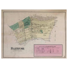
An amazing Antique 1870 Map Flatbush Brooklyn New York, Hand Water colored, Includes Prospect Park in Brooklyn and Flatbush Village. Unframed and in ...
Category
Late 19th Century American Antique Beers Atlas Co. Folk Art
Materials
Paper
1870 Map of Greenport Long Island New York
By Beers Atlas Co.
Located in Sag Harbor, NY
Antique 1872 Beers Hand Colored map of Greenport Long Island New York. Amazing original map. Condition is amazing, beautiful patina and condition....
Category
Late 19th Century American Antique Beers Atlas Co. Folk Art
Materials
Paper
Beers Atlas Co. folk art for sale on 1stDibs.
Beers Atlas Co. folk art are available for sale on 1stDibs. These distinctive items are frequently made of paper and are designed with extraordinary care. There are many options to choose from in our collection of Beers Atlas Co. folk art, although gray editions of this piece are particularly popular. Many of the original folk art by Beers Atlas Co. were created in the Victorian style in united states during the 19th century. Prices for Beers Atlas Co. folk art can differ depending upon size, time period and other attributes — on 1stDibs, these items begin at $1,275 and can go as high as $1,475, while a piece like these, on average, fetch $1,375.
