P.F. Howells More Furniture and Collectibles
to
1
1
1
1
1
1
1
1
1
1
1
1
1
1
1,028
215
202
174
Creator: P.F. Howells
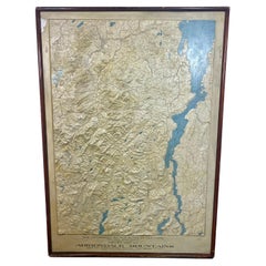
Rare and Early Plaster Relief Map of Adirondack Mountains by F J H Merrill
By P.F. Howells, E. W. Merrill
Located in Buffalo, NY
Rare and Early Monumental Plaster Relief Map of Adirondack Mountains by The University of the State of New York, New York State Museum..F J H Merrill director,,,modeled by Howell's ...
Category
1910s American Industrial Vintage P.F. Howells More Furniture and Collectibles
Materials
Plaster, Wood
Related Items
Rare Antique Map of Southwestern Europe and West Africa by V.M. Coronelli, 1692
By Vincenzo Coronelli
Located in Langweer, NL
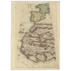
Antique Globe Gore: Southwestern Europe and West Africa by Vincenzo Coronelli
This exquisite, hand-colored globe gore by Vincenzo Coronelli, one of the most renowned 17th-century cartographers, represents Southwestern Europe and West Africa. A segment of Coronelli's monumental 42-inch terrestrial globe, this gore is a remarkable example of the artistry and geographical knowledge of the late 1600s. Covering France, the Iberian Peninsula, and all of Africa west of a line extending from Algeria to the Bight of Benin, it also includes the Canary Islands and Madeira.
Coronelli’s globe gores are celebrated for their exceptional engraving and accuracy, and this piece is no exception. The coastline of Africa is depicted with remarkable precision for its time, reflecting the latest geographical knowledge of European explorers. In contrast, the interior of Africa—still a mystery to European mapmakers—features mythical elements such as fantastical mountain ranges and exotic fauna. Giraffes, elephants, lions, and mysterious giant birds populate the landscape, offering a glimpse into the imagination and curiosity of the era. One notable detail is the Gambia...
Category
Late 17th Century Antique P.F. Howells More Furniture and Collectibles
Materials
Paper
$2,336 Sale Price
20% Off
H 19.3 in W 13.59 in D 0.02 in
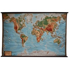
World Relief Map
Located in Antwerp, BE
Large world relief map.
Measures: Width 232 cm.
Height 158 cm.
Category
Mid-20th Century German Mid-Century Modern P.F. Howells More Furniture and Collectibles
Materials
Acrylic
Relief Atlas Map of Africa by Hachette – Antique c.1883 French Map
Located in Langweer, NL
Antique Map of Africa – Relief Atlas Map by Hachette, circa 1880
Description:
This is an attractive antique map titled “Afrique,” published by Hachette...
Category
Late 19th Century Antique P.F. Howells More Furniture and Collectibles
Materials
Paper
$464
H 10.12 in W 12.84 in D 0.01 in
Rare Antique Bible Map of Southern Europe by A. Schut, 1743
Located in Langweer, NL
Antique map of the Mediterranean and a large part of Europe, illustrating the voyage of St. Paul to Rome. This map originates from ‘Biblia Sacra, dat is, de H. Schriftuer van het Oud...
Category
Mid-18th Century Antique P.F. Howells More Furniture and Collectibles
Materials
Paper
$519 Sale Price
33% Off
H 15.44 in W 21.26 in D 0.02 in
Antique Map of North America – Physical Relief Map by Hachette c.1883
Located in Langweer, NL
Antique Map of North America – Physical Relief Map by Hachette c.1883
Description:
This antique map titled “Amérique du Nord” was published around 1883 by E. Hachette in Paris as pa...
Category
Late 19th Century French Antique P.F. Howells More Furniture and Collectibles
Materials
Paper
$464
H 10.12 in W 12.84 in D 0.01 in
1889 Map of Italy in 3D Relief
Located in Weesp, NL
Introducing a true gem for collectors and history enthusiasts alike: this rare 1889 *"Italia in Rilievo"* map by L. Roux & Co. from Torino, a masterpiece of craftsmanship and cartogr...
Category
1880s European Antique P.F. Howells More Furniture and Collectibles
Materials
Paper
Rare Set of 3 Map Samplers by A Charles. Italy, Spain & France
Located in Chelmsford, Essex
Set of 3 Map Samplers by A Charles. All depict countries, cities, seas and landmarks of the respective countries. The first entitled, 'SPAIN and PORTUGAL'. The second, 'MAP OF FRANCE...
Category
Early 19th Century English Antique P.F. Howells More Furniture and Collectibles
Materials
Linen
$3,417 / set
H 6.3 in W 8.3 in D 1.6 in
Rare and Early Map of the Seventeen Provinces, Published in circa 1640
Located in Langweer, NL
Antique map titled 'Carte Generale des Dixsept Provinces des Pais Bas'. Rare and Early map of the Seventeen Provinces. The Seventeen Provinces were the Imperial states of the Habsbur...
Category
Mid-17th Century Antique P.F. Howells More Furniture and Collectibles
Materials
Paper
$2,098 Sale Price
20% Off
H 23.08 in W 16.93 in D 0.02 in
Rare Small Antique Map of Great Britain and Ireland
Located in Langweer, NL
Antique map titled 'La Grande Bretagne et Irlande'. Small antique map of Great Britain and Ireland. Source unknown, to be determined. Publ...
Category
Mid-18th Century Antique P.F. Howells More Furniture and Collectibles
Materials
Paper
$219 Sale Price
20% Off
H 6.58 in W 7.21 in D 0.02 in
Relief Atlas Map of Asia by Hachette – Antique French Map, circa 1883
Located in Langweer, NL
Antique Map of Asia – Relief Atlas Map by Hachette, circa 1883
Description:
This antique map titled “Asie” was published by Hachette in Paris around 1883 and originates from their e...
Category
Late 19th Century French Antique P.F. Howells More Furniture and Collectibles
Materials
Paper
$464
H 10.12 in W 12.84 in D 0.01 in
Antique Map of the Rivers and Mountains in Asia, c.1895
By Meyer
Located in Langweer, NL
Antique map titled 'Asien. Fluss- und Gebirgssysteme.' Map of Asia, showing river- and mountain systems. This map originates from 'Meyers grosses Konversations-Lexikon.', published in Leipzig and Vienna. Meyers Konversations-Lexikon was a major German encyclopedia that existed in various editions from 1839 until 1984, when it merged with the Brockhaus encyclopedia. Several of the plates were also used in Dutch Encyclopedia's like Winkler Prins...
Category
19th Century Antique P.F. Howells More Furniture and Collectibles
Materials
Paper
$85 Sale Price
20% Off
H 9.65 in W 12.21 in D 0 in
Antique 1882 Antique Map of Peru and Bolivia: Andes Mountains and Amazon Rivers
Located in Langweer, NL
Antique 1882 Map of Peru and Bolivia: Andes Mountains, Amazon Rivers, Historic Borders
This map from 1882 provides a detailed representation of the countries of Peru and Bolivia in ...
Category
1880s Antique P.F. Howells More Furniture and Collectibles
Materials
Paper
$297
H 14.97 in W 22.45 in D 0 in
P.f. Howells more furniture and collectibles for sale on 1stDibs.
P.F. Howells more furniture and collectibles are available for sale on 1stDibs. These distinctive items are frequently made of wood and are designed with extraordinary care. Many of the original more furniture and collectibles by P.F. Howells were created in the industrial style in united states during the 1910s. If you’re looking for additional options, many customers also consider more furniture and collectibles by Stanley, Schoenhut, and Denoyer-Geppert. Prices for P.F. Howells more furniture and collectibles can differ depending upon size, time period and other attributes — on 1stDibs, these items begin at $3,200 and can go as high as $3,200, while a piece like these, on average, fetch $3,200.


