Items Similar to Antique Map of Victoria ‘Australia’ by J. Tallis, circa 1855


Want more images or videos?
Request additional images or videos from the seller
1 of 5
Antique Map of Victoria ‘Australia’ by J. Tallis, circa 1855
About the Item
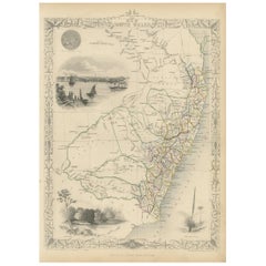
A highly decorative and finely engraved mid-19th century map of Victoria, Australia which appeared in John Tallis & co.'s The Illustrated Atlas (London & New York, circa 1855).
The Illustrated Atlas, published from 1849, was the last decorative world atlas. The map of Victoria was typical of the many fine ones which appeared in this work with its ornamental border and attractive vignettes. Illustrated are views of Melbourne, the River Glenelg, native Australians (Aborigines) and Kangaroos.
- Dimensions:Height: 10.56 in (26.8 cm)Width: 14.73 in (37.4 cm)Depth: 0.02 in (0.5 mm)
- Materials and Techniques:
- Period:
- Date of Manufacture:circa 1855
- Condition:Please study image carefully.
- Seller Location:Langweer, NL
- Reference Number:
About the Seller
5.0
Platinum Seller
These expertly vetted sellers are 1stDibs' most experienced sellers and are rated highest by our customers.
Established in 2009
1stDibs seller since 2017
1,933 sales on 1stDibs
Typical response time: <1 hour
- ShippingRetrieving quote...Ships From: Langweer, Netherlands
- Return PolicyA return for this item may be initiated within 14 days of delivery.
More From This SellerView All
- Antique Map of Belgium by J. Tallis, circa 1851Located in Langweer, NLA highly decorative and detailed mid-19th century map of Belgium which was drawn and engraved by J. Rapkin (vignettes by J. Marchant and J. B. Allen) an...Category
Antique Mid-19th Century Maps
MaterialsPaper
- Antique Map of Switzerland by J. Tallis, circa 1851Located in Langweer, NLA decorative and detailed mid-19th century map of Switzerland which was drawn and engraved by J. Rapkin (vignettes by A. H. Wray & J. B. Allen) and published in John Tallis's Illustr...Category
Antique Mid-19th Century Maps
MaterialsPaper
- Antique Map of Asia Minor by J. Tallis, circa 1851Located in Langweer, NLA highly decorative mid-19th century map of 'Asia Minor' (modern day Turkey) which was drawn and engraved by J. Rapkin and published in John Tallis's Illust...Category
Antique Mid-19th Century Maps
MaterialsPaper
- Antique Map of Northern Italy by J. Tallis, circa 1851Located in Langweer, NLA highly decorative mid-19th century map of Northern Italy which was drawn and engraved by John Rapkin (vignettes by A. H. Wray & J. B. Allen) and published in John Tallis & co.'s Th...Category
Antique Mid-19th Century Maps
MaterialsPaper
- Antique Map of Southern Italy by J. Tallis, circa 1851Located in Langweer, NLDecorative and detailed mid-19th century map of Southern Italy which was drawn and engraved by John Rapkin (vignettes by A. H. Wray and J. Rogers...Category
Antique Mid-19th Century Maps
MaterialsPaper
- Antique Map of New South Wales by Tallis, circa 1851Located in Langweer, NLAntique map titled 'New South Wales'. Decorative and detailed map of New South Wales which was drawn and engraved by J. Rapkin (vignettes by H. Warren ...Category
Antique Mid-19th Century Maps
MaterialsPaper


You May Also Like
- Original Antique Map of Belgium by Tallis, Circa 1850Located in St Annes, LancashireGreat map of Belgium Steel engraving Many lovely vignettes Published by London Printing & Publishing Co. ( Formerly Tallis ), C.1850 Origin...Category
Antique 1850s English Maps
MaterialsPaper
- Original Antique Map / City Plan of Brussels by Tallis, circa 1850Located in St Annes, LancashireGreat map of Brussels. Steel engraving. Published by London Printing & Publishing Co. (Formerly Tallis), C.1850 Free shipping.Category
Antique 1850s English Maps
MaterialsPaper
- Original Antique Map of South America, circa 1830Located in St Annes, LancashireGreat map of South America Copper plate engraving Published by Butterworth, Livesey & Co., circa 1830 Unframed.Category
Antique Early 1800s English Other Maps
MaterialsPaper
- Original Antique Map of South East Asia by Becker, circa 1840Located in St Annes, LancashireGreat map of South East Asia Steel engraving with original color outline Engraved by Becker Published by Virtue, circa 1840. Unframed.Category
Antique 1840s English Other Maps
MaterialsPaper
- Original Antique Map of Spain and Portugal, circa 1790Located in St Annes, LancashireSuper map of Spain and Portugal Copper plate engraving by A. Bell Published, circa 1790. Unframed.Category
Antique 1790s English Other Maps
MaterialsPaper
- Antique Map of Italy by Andriveau-Goujon, 1843By Andriveau-GoujonLocated in New York, NYAntique Map of Italy by Andriveau-Goujon, 1843. Map of Italy in two parts by Andriveau-Goujon for the Library of Prince Carini at Palazzo Carini i...Category
Antique 1840s French Maps
MaterialsLinen, Paper


Recently Viewed
View AllMore Ways To Browse
Furniture Used Victoria
Used Victoria Furniture
Used Furniture In Victoria
Victoria Antique Furniture
Used Victoria Antiques
Used Victoria Furniture Antiques
Used Victoria Antique Furniture
Antique Furniture In Australia
Melbourne Used Furniture
19th Century Australian Furniture
Used Furniture In Melbourne
Antique Melbourne
Antique Furniture Melbourne
Antique Furniture In Melbourne
Used Office Furniture Melbourne
Map Of Victoria
Antique Victoria Australia
Antique Furniture Melbourne Australia