Items Similar to Rare Hand-Colored Antique Map of Asia, 1788


Want more images or videos?
Request additional images or videos from the seller
1 of 5
Rare Hand-Colored Antique Map of Asia, 1788
About the Item
Antique map titled 'Kaartje van Asia'.
Original antique map of Asia. This map originates from 'Nieuwe Natuur- Geschied- en Handelkundige Zak- en Reisatlas' by N.T. Gravius, 1788.
Artists and Engravers: N.T. Gravius was a publisher from Amsterdam.
- Dimensions:Height: 8.08 in (20.5 cm)Width: 11.03 in (28 cm)Depth: 0 in (0.02 mm)
- Materials and Techniques:
- Period:1780-1789
- Date of Manufacture:1788
- Condition:Wear consistent with age and use.
- Seller Location:Langweer, NL
- Reference Number:
About the Seller
5.0
Platinum Seller
These expertly vetted sellers are 1stDibs' most experienced sellers and are rated highest by our customers.
Established in 2009
1stDibs seller since 2017
1,916 sales on 1stDibs
Typical response time: <1 hour
- ShippingRetrieving quote...Ships From: Langweer, Netherlands
- Return PolicyA return for this item may be initiated within 14 days of delivery.
More From This SellerView All
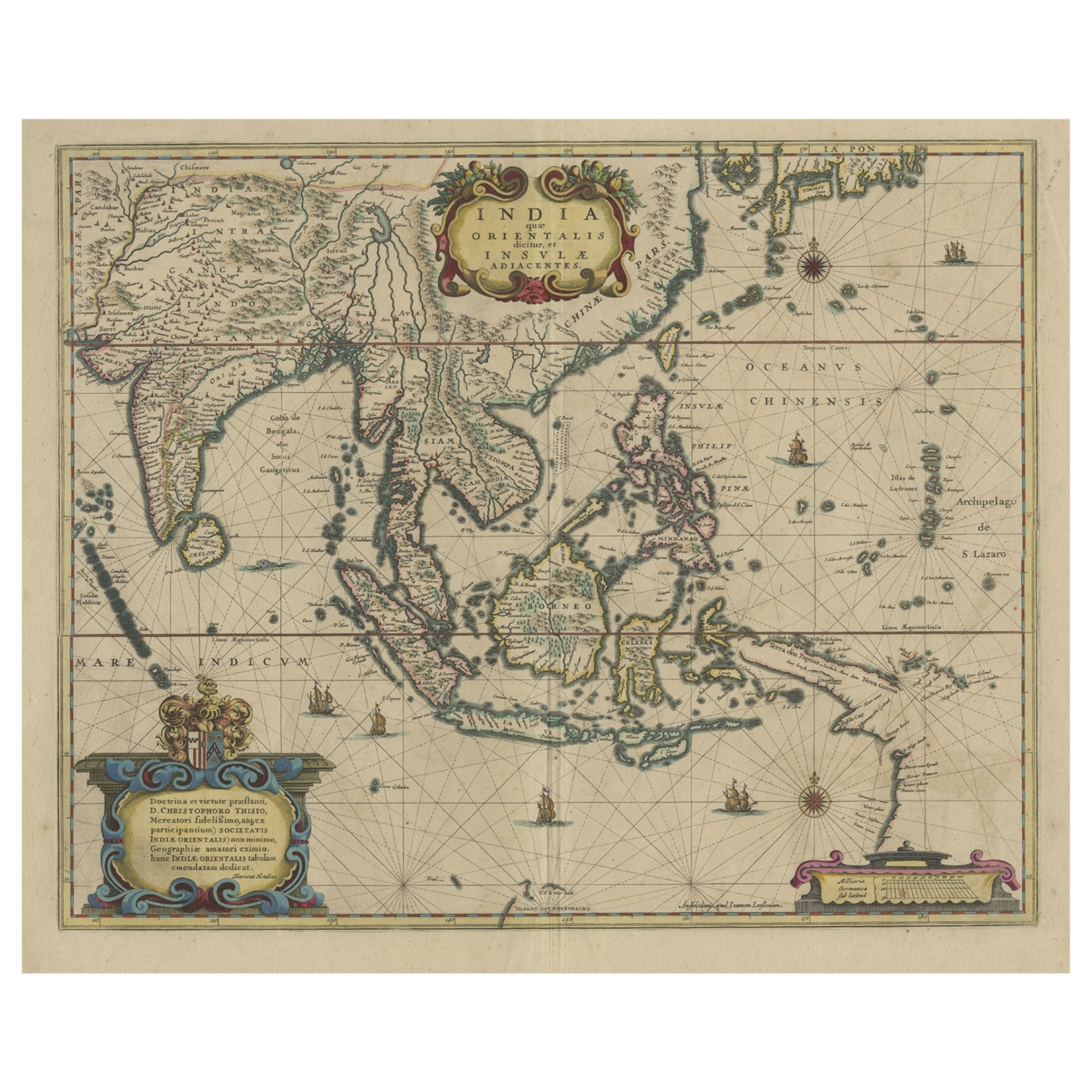
- Original Antique Hand-Colored Map of The East Indies and Southeast Asia, c.1644Located in Langweer, NLAntique map titled 'India quae Orientalis dicitur, et Insulae adiacentes'. Old map of the East Indies and Southeast Asia showing the area between India in the West and parts of J...Category
Antique 1640s Maps
MaterialsPaper
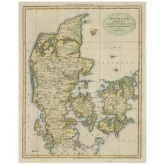
- Antique Hand-Colored Engraved Map of Denmark, 1790Located in Langweer, NLPublished by Russell (J. C.). Denmark. Divided into Dioceses and Prefectures compiled from the best Authorities, 1790, hand-coloured engraved map on handmade paper with watermark. 41...Category
Antique 1790s Maps
MaterialsPaper
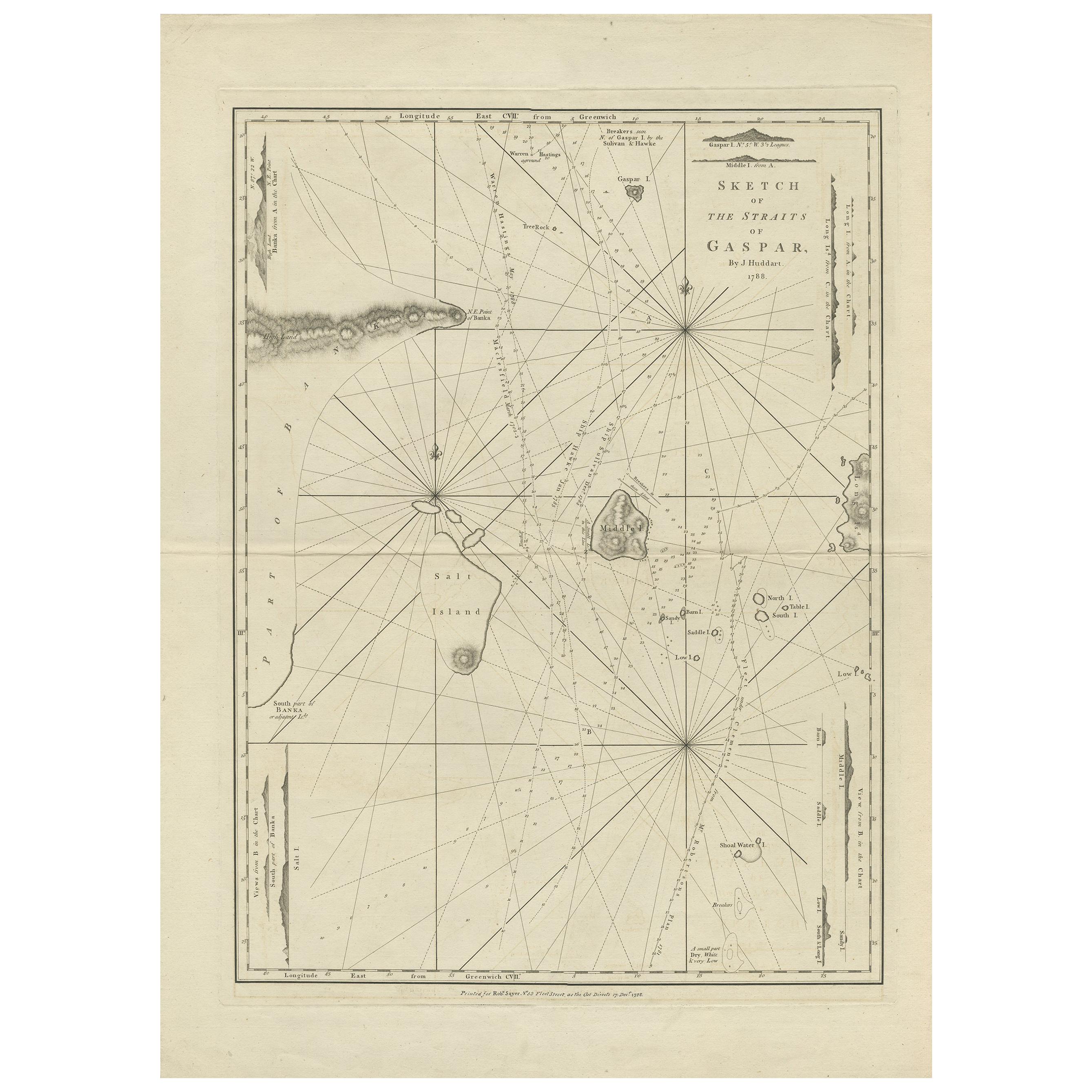
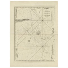
- Antique Map of the Gaspar Strait by Huddart, '1788'Located in Langweer, NLAntique map titled 'Sketch of the Straits of Gaspar'. Detailed sea chart of the Gaspar Strait, showing part of the Island of Banca on the east coast of Sumatra just to the south of S...Category
Antique Late 18th Century Maps
MaterialsPaper
- Antique Map of Switzerland by Keizer & de Lat, 1788Located in Langweer, NLAntique map titled 'La Suisse (..)'. Uncommon original antique map of Switzerland. This map originates from 'Nieuwe Natuur- Geschied- en Handelkundige Zak- en Reisatlas' by Gerrit Br...Category
Antique Late 18th Century Maps
MaterialsPaper
- Antique Map of the World on Mercator's Projection, 1788Located in Langweer, NLAntique map titled 'Kaart van de Geheele Wereld (..)'. Uncommon small world map on Mercator's projection. Nice detail of the islands throughout the wor...Category
Antique Late 18th Century Maps
MaterialsPaper
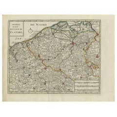
- Antique Map of Flanders by Keizer & de Lat, 1788Located in Langweer, NLAntique map titled 'Nouvelle Carte du Comté de Flandre'. Uncommon original antique map of Flanders, Belgium. This map originates from 'Nieuwe Natuur- Geschied- en Handelkundige Zak- ...Category
Antique Late 18th Century Maps
MaterialsPaper


You May Also Like
- Original Antique Map of Asia. C.1780Located in St Annes, LancashireGreat map of Asia Copper-plate engraving Published C.1780 Two small worm holes to right side of map Unframed.Category
Antique Early 1800s English Georgian Maps
MaterialsPaper

- Hand-Colored 18th Century Homann Map of the Black Sea, Turkey and Asia MinorBy Johann Baptist HomannLocated in Alamo, CAAn attractive original early 18th century hand-colored map of the Black Sea and Turkey entitled "Carte de L'Asie Minevre ou de la Natolie et du Pont Evxin Tiree des Voyages et des Ob...Category
Antique Early 18th Century German Maps
MaterialsPaper
- Original Antique Map of South East Asia, Arrowsmith, 1820Located in St Annes, LancashireGreat map of South East Asia Drawn under the direction of Arrowsmith Copper-plate engraving Published by Longman, Hurst, Rees, Orme and Brown, 1820 Unframed.Category
Antique 1820s English Maps
MaterialsPaper
- England, Scotland & Ireland: A Hand Colored Map of Great Britain by TirionBy Isaak TirionLocated in Alamo, CAThis is a hand-colored double page copperplate map of Great Britain entitled "Nieuwe Kaart van de Eilanden van Groot Brittannien Behelzende de Kon...Category
Antique Mid-18th Century Dutch Maps
MaterialsPaper
- 17th Century Hand-Colored Map of West Africa by Mercator/HondiusLocated in Alamo, CAA 17th century hand-colored map entitled "Guineae Nova Descriptio" by Gerard Mercator and Jodocus Hondius, published in their 'Atlas Minor' in Amsterdam in 1635. It is focused on the...Category
Antique Mid-17th Century Dutch Maps
MaterialsPaper
- Original Antique Map of South East Asia by Becker, circa 1840Located in St Annes, LancashireGreat map of South East Asia Steel engraving with original color outline Engraved by Becker Published by Virtue, circa 1840. Unframed.Category
Antique 1840s English Other Maps
MaterialsPaper


Recently Viewed
View AllMore Ways To Browse
Hand Colored Antique
Antique Furniture East London
Antique Eastern European Furniture
Antique House Plans
Antique Metal Window
Antique Metal Windows
Antique Furniture Rollers
Antiques Compasses
India Map
Antique Map Book
Antique Maps Book
Antique Italian Maps
Antique Italy Maps
Antique Map Italy
Antique Maps Italy
Antique Italian Map
Antique Italy Map
Italy Antique Map