Items Similar to Navy Five-Star Admirals Signatures, United States World War II


Video Loading
Want more images or videos?
Request additional images or videos from the seller
1 of 7
Navy Five-Star Admirals Signatures, United States World War II
About the Item
This amazing piece of U.S. Naval history features signed items from all four World War II Navy Admirals to ever wear the five-star rank. All are considered some of the finest admirals in the history of the Navy. Especially Chester Nimitz and William Halsey, both were instrumental in turning around the fortunes of the United States after the Japanese surprise attack on Pearl Harbor.
Chester Nimitz (1885-1966) was an American admiral, Commander in Chief of the U.S. Pacific Fleet during World War II, and largely responsible for the successful "island-hopping" campaign against the Japanese. The collage includes a Nimitz signed slip of paper with rank as well as, a war dated (July 16, 1942) letter from the Admiral's Flag Secretary, regarding the autograph.
William F Halsey (1882-1959) was an American admiral who led the task force attack on the Marshall and Gilbert islands and became commander of Allied naval forces in South Pacific commanding at the Solomon Islands and Leyte Gulf. Featured in the collage is a signed "W. F. Halsey" card.
Ernest J. King (1878-1956) was Commander in Chief, United States Fleet and Chief of Naval Operations. During World War II he directed the United States Navy's operations, planning, and administration and was a member of the Joint Chiefs of Staff. Included in the collage is a war dated (December 19, 1943) letter signed with rank by Admiral King.
William D. Leahy (1875-1959) was an American naval officer who served as the senior-most United States military officer on active duty during World War II. He held multiple titles and was at the center of all the major military decisions the United States made during the war. Featured in the collage is the admiral's business card as Ambassador of the United States -- signed in full.
Also included in this amazing U.S. Navy collage is photographs of each admiral as well as the five-star rank that each would have worn.
CONDITION:
Overall very good condition. All signatures are in dark ink and clearly legible. The letter signed by Nimitz has fold lines, one light stain, and the edges have been cut but no text is affected. The letter signed by King has fold lines and the paper is healthy. Halsey's signature card is clean and bright. Leahy's card is lightly soiled and has "1946" written in another ink. The collage is presented using the finest archival materials and procedures.
- Dimensions:Height: 37.5 in (95.25 cm)Width: 41 in (104.14 cm)Depth: 2 in (5.08 cm)
- Materials and Techniques:
- Place of Origin:
- Period:
- Date of Manufacture:Mid-20th Century
- Condition:Wear consistent with age and use.
- Seller Location:Colorado Springs, CO
- Reference Number:
About the Seller
4.9
Platinum Seller
These expertly vetted sellers are 1stDibs' most experienced sellers and are rated highest by our customers.
Established in 2010
1stDibs seller since 2011
400 sales on 1stDibs
Typical response time: <1 hour
- ShippingRetrieving quote...Ships From: Colorado Springs, CO
- Return PolicyA return for this item may be initiated within 10 days of delivery.
More From This SellerView All
- 1879 "United States of America, Western Part" by O. J. StuartLocated in Colorado Springs, COThis colorful original map, titled “United States of America, Western Part,” was issued in Volume 16 of “The American Cyclopædia.” A detailed reference map, the map was printed in co...Category
Antique 1870s American Maps
MaterialsPaper
- 1847 Ornamental Map of the United States & Mexico by H. PhelpsLocated in Colorado Springs, COOffered is an original 1847 ornamental map of the U.S. entitled "Ornamental Map of the United States & Mexico" by Humphrey Phelps. The map was issued as an act of Congress by Phelps on Fulton Street, New York. The broadside is elaborately hand-colored. This is a very detailed and graphic propaganda map of the United States expressing U.S. dominance of the North American continent. The hand-colored map proclaims the Manifest Destiny, with the recent acquisition of Upper California and Texas at the conclusion of the Mexican-American War. The newly acquired land is boldly colored, standing in stark contrast to the rest of the U.S. The map details a potential route for a railroad running from New York City, to Buffalo, to Chicago, then west along the Oregon Trail to Oregon City. This route anticipates the construction of the transcontinental railroad by nearly 20 years. The map includes elaborately detailed renderings of George Washington, Hernan Cortez, and Montezuma at top to represent European expansion to the Americas. At bottom are four inset designs with text showing the following: a chronological history of the U.S. beginning from settlement to the U.S. victory in the Mexican-American war; an illustration of General Zachary Taylor with details on the Oregon Territory; an illustration of the Aztec Temple of the Sun in Tenochtitlan and a chronology of the Conquest of the Aztec Empire under Cortez; a portrait of General Antonio Lopez de Santa Anna...Category
Antique 1840s American Maps
MaterialsPaper
- 1859 "Map of the United States of America..." by J. H. ColtonBy J.H. ColtonLocated in Colorado Springs, COPresented is an 1859 “Map of the United States of America, the British Provinces, Mexico, the West Indies and Central America with Part of...Category
Antique 1850s American Maps
MaterialsPaper
- 1866 Ensign & Bridgman's Rail Road Map of the United StatesLocated in Colorado Springs, COPresented is an 1866 issue of “Ensign & Bridgeman’s Rail Road Map of the United States, showing Depots & Stations.” First published in 1856, this is the third edition, following anot...Category
Antique 1860s American Late Victorian Maps
MaterialsPaper
- "The United States from the Latest Authorities" Antique Wall Map, 1835Located in Colorado Springs, COThis is a 1835 map of “The United States from the Latest Authorities” by Ezra Strong. A hand-colored engraved wall map of the eastern half of the United States, this map has a large inset of the "Oregon District" and several engraved city views and two portraits. The primary map extends to Mexico Texas and the Missouri Territory, showing the course of the Missouri River to Ft. Mandan and Old Ft. Mandan, and noting many forts along the river. The territories to the east of Missouri Territory are separately delineated as Sioux District and Huron District. The western details of the map are very good for a map of this time period, with many Native American settlements, villages, forts and other details noted. The map is bordered with vignettes of Boston, New York, Philadelphia, Hartford, Cincinnati, and Baltimore. Each vignette notes the date settled, primary settler, and the population as of 1830. Two portraits of LaFayette and George Washington are presented in full length with related biographical information. A large inset map at lower right shows the Oregon District, centered on the Columbia River and extending to the Rocky Mountains. This is one of the earliest commercial appearances of a separate map of Oregon...Category
Antique 1830s American Maps
MaterialsPaper
- "For Defense, Buy United States Savings Bonds and Stamps." Vintage WWII PosterLocated in Colorado Springs, COThis is a vintage savings bond poster from WWII, dating to 1941. The poster reads "For Defense. Buy United States Savings Bonds and Stamps. Ask About Our Pay Roll Allotment Plan" in dark green, teal, and red lettering. The poster was published in Washington, D.C. by the U. S. Government Printing Office. It depicts the Concord Minute Man...Category
Vintage 1940s American Posters
MaterialsPaper


You May Also Like
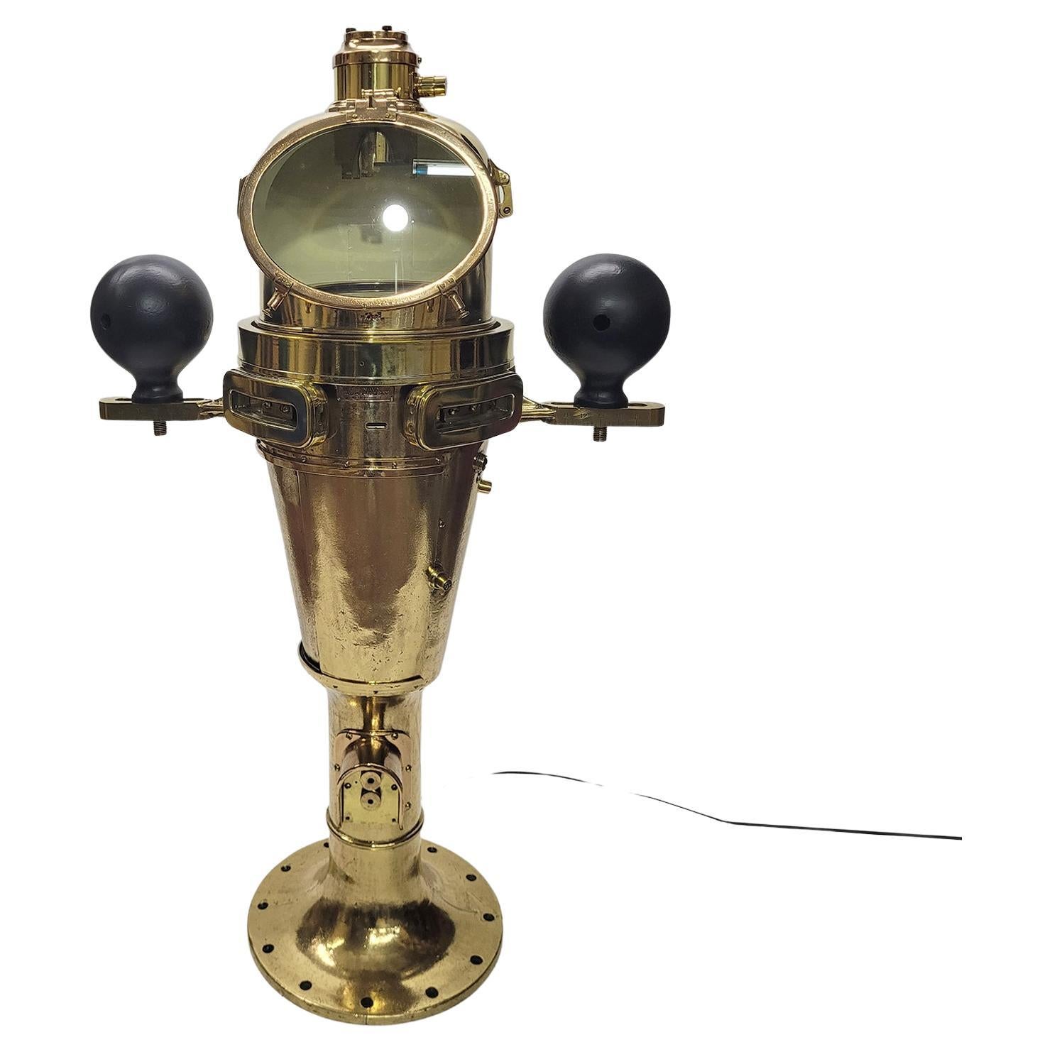
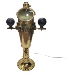
- World War I US Navy Ships BinnacleLocated in Norwell, MASpectacular solid brass ships binnacle by Keuffel and Esser Company of New York in 1918. Builders plate is marked type VII no 1200, Bureau of Navigation, US Navy...Category
Vintage 1910s North American Nautical Objects
MaterialsBrass
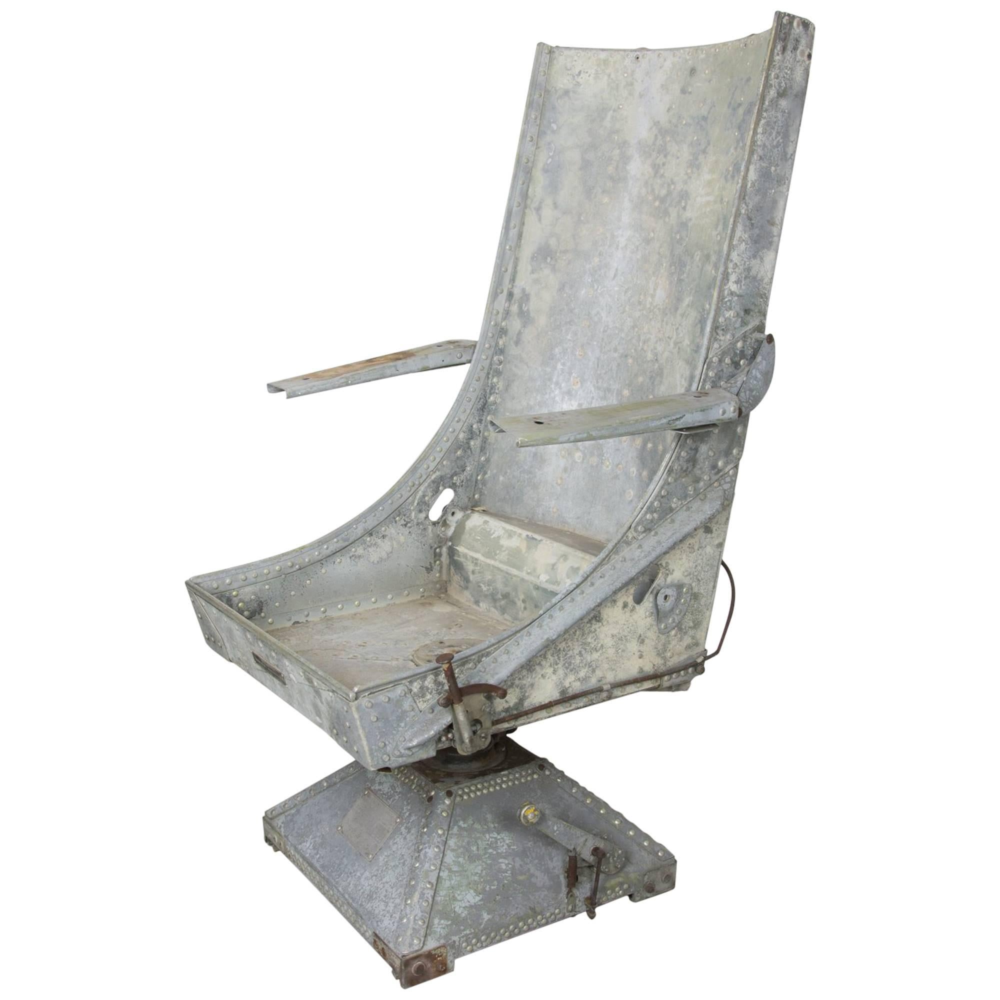
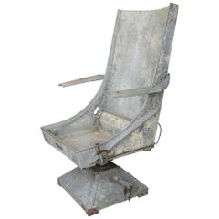
- World War II Air Crewman's Seat.Located in Asbury Park, NJRare aircrew seat by Aircraft Mechanics Inc. with swivel base. The body is riveted, galvanized, and well patinated. Adjustment levers have faded bright yellow spherical knobs. Ready ...Category
Vintage 1930s American Industrial Armchairs
MaterialsAluminum
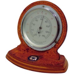
- S.S. United States ThermometerLocated in Hanover, MAVintage SS United States Thermometer by the British Rototherm Co. Ltd. London, England About 4.75" high and 5.25" wide. This table/desk top thermometer is in a leather clad wood case...Category
Vintage 1950s British Mid-Century Modern Nautical Objects
MaterialsLeather
- 1889 North Dakota 39 Star United States of America Statehood FlagLocated in Coeur d'Alene, ID39 star silk statehood flag. 23 1/2" x 15". Was the unofficial North Dakota Flag. As South Dakota was also admitted as the 40th state on the same day this...Category
Antique 1880s American Historical Memorabilia
MaterialsSilk
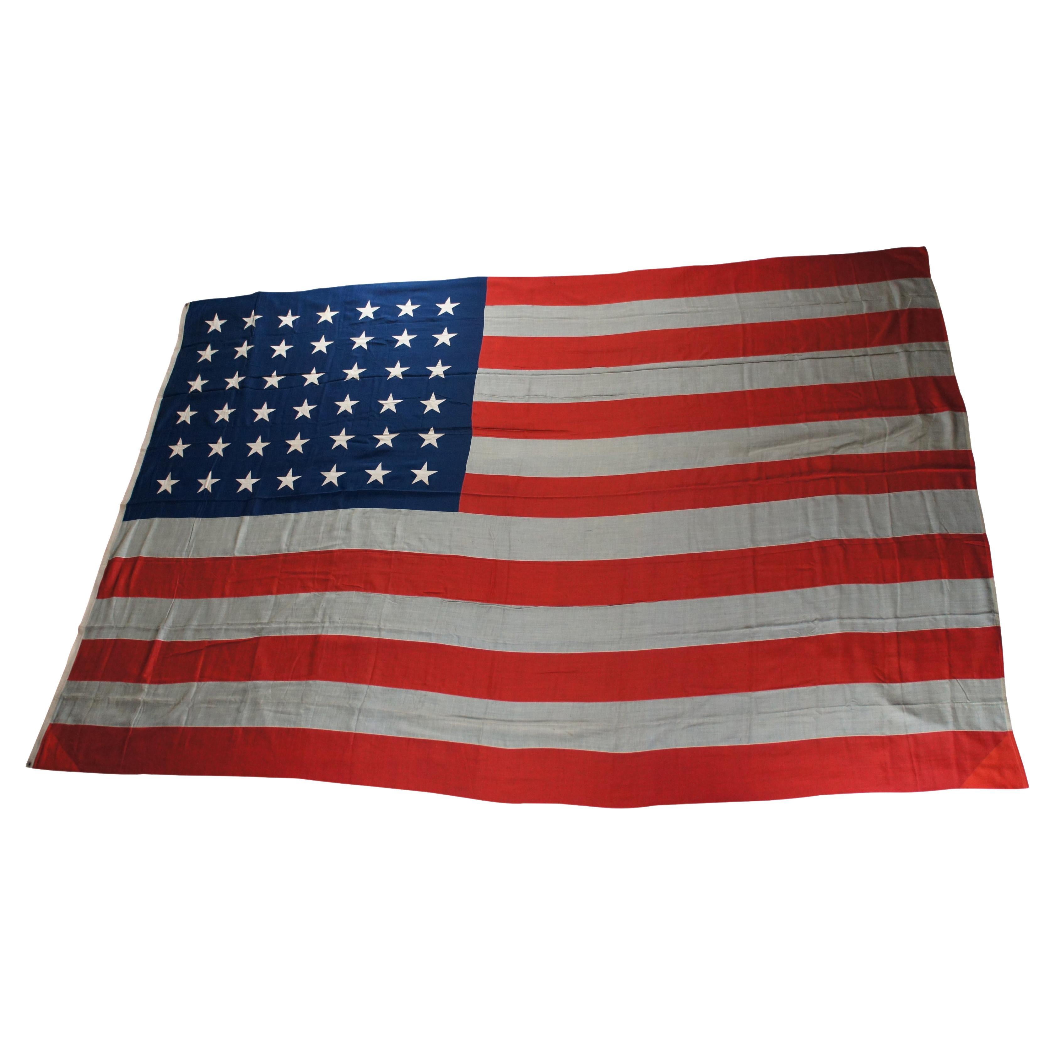
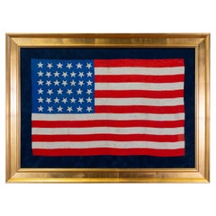
- Rare Monumental 1890 Antique 42 Star United States of America FlagLocated in Dayton, OHMonumental fifteen foot 42 star American flag, circa 1889-1890. The 42-star flag is rare because only a limited number of 42-star flags were produced after Washington became a state on Nov. 11, 1889. But it takes a more intimate knowledge of flag trivia to know just why it happened this way. White stars are added to the blue field of the star-spangled banner on the Fourth of July after a state is admitted to the union. In the fall of 1889, several western territories became states. Dakota was admitted, and then split into North and South Dakota, on Nov. 2, 1889, which made them state and star numbers 39 and 40. Montana was named the 41st state on Nov. 8, followed by Washington, on Nov. 11. Only a few flag manufacturers began producing 42-star flags before the official addition of the 42nd star on July 4, 1890. Those who tried to jump the gun by being the first to produce an up-to-date flag were surprised when Idaho was admitted to the United States on July 3...Category
Antique 1890s American Classical Historical Memorabilia
MaterialsCotton
- Vintage Framed United States MapLocated in New York, NYVintage aged paper map of the United States mounted on particle board and framed in a simple wooden frame.Category
20th Century American Mid-Century Modern Maps
MaterialsWood, Paper


Recently Viewed
View AllMore Ways To Browse
United States
S S United States
United States Lines
World War Furniture
Mid Century Star
American Signature Furniture
World War Ii Furniture
United States Navy
Used American Signature Furniture
Vintage War Items
Pacific Furniture Mid Century
Archive 20th Century Furniture
Navy Cut
Military Officer
Star Wars Retro
United States Flag Vintage
Star Wars Memorabilia
Vintage Black Memorabilia Collectibles