Items Similar to 1616 Petrus Bertius Map of Arakan and Pegu in Southeast Asia


Want more images or videos?
Request additional images or videos from the seller
1 of 10
1616 Petrus Bertius Map of Arakan and Pegu in Southeast Asia
$395.59
£293.87
€330
CA$549.32
A$599.43
CHF 314.41
MX$7,280.33
NOK 3,927.20
SEK 3,711.40
DKK 2,512.26
About the Item
Title: 1616 Petrus Bertius Map of Arakan and Pegu in Southeast Asia
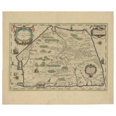
Description: This early seventeenth-century map, titled Descriptio Arachan et Pegu, was published in 1616 by Petrus Bertius, a renowned Dutch cartographer and historian. It depicts the regions of Arakan, Pegu, Bengal, and Cochin-China, covering parts of present-day Myanmar, Bangladesh, and Thailand. Originally created for the Caert-Thresoor atlas by Barent Langenes in 1598, this version was reissued in Bertius' 1616 edition of Tabularum Geographicarum Contractarum, a significant geographic work of the early seventeenth century.
The map is oriented with north positioned to the left, a common characteristic of early Dutch cartography. It reflects European knowledge of Southeast Asia at the time, based on reports from Portuguese and Dutch explorers. The depiction of the Gulf of Bengal, major rivers, trading ports, and settlements highlights the importance of this region in the spice and maritime trade networks.
The decorative cartouche in the lower-left corner contains the title “Arachan & Pegu,” with the full Latin title appearing at the top margin. The map is beautifully hand-colored, with shades of yellow, green, and red marking different territories and key locations.
Several major geographic features and cities are labeled, including Cochin-China, representing modern-day Vietnam, Siam, referring to present-day Thailand, Pegu, a historic kingdom in Myanmar, Aracam or Arakan, a coastal region of western Myanmar, and Bengala, representing Bengal and parts of modern Bangladesh. The Menam River is marked, which was an early European reference to the Chao Phraya River in Thailand. Macao, a key Portuguese trading settlement in China, is also identified, indicating the influence of Portuguese exploration in the region.
Small red city symbols are used to indicate major settlements, ports, and fortresses, showing the economic and political centers of the time.
Bertius' works were highly influential and were published in multiple languages, including Latin, French, and German. His 1616 edition of this map was intended for European scholars, traders, and navigators interested in geography, commerce, and exploration during the height of Dutch maritime expansion.
Cartographer and Source: Petrus Bertius, who lived from fifteen sixty-five to sixteen twenty-nine, was a Dutch theologian, historian, and cartographer known for his geographic atlases. His 1616 edition of Tabularum Geographicarum Contractarum contained small but highly detailed maps originally engraved by Barent Langenes and Jodocus Hondius. These maps were widely circulated and provided European audiences with some of the best geographic knowledge of the time.
Condition Report:
The paper is well-preserved, with a fine laid texture and visible chain lines characteristic of early seventeenth-century Dutch printing. The engraving remains sharp, with clearly defined labels and delicate line work capturing the regional geography.
There is light age-toning, particularly along the edges, which is typical for antique maps of this period. The original hand-coloring is well preserved, with only slight fading in some areas. The margins remain intact, with minor text bleed-through from the reverse, a common feature in books of this period. There are no major tears, repairs, or stains, making this a fine and collectible example of an early Southeast Asian map.
Framing Recommendations:
To ensure proper preservation and display, museum-quality archival materials are recommended.
For matting and backing, acid-free, museum-grade board should be used to prevent further aging. A double mat with a neutral outer mat and a gold or soft red inner accent can enhance the map’s historical character.
A classic dark walnut, black, or gilded wooden frame will suit the map’s early seventeenth-century aesthetic. An antique-style frame with subtle carvings can further complement its Renaissance-era design.
To protect the map, UV-resistant museum glass or acrylic is recommended to prevent fading. Anti-reflective glass will allow for clear visibility of the intricate details without glare.
For mounting, avoid direct adhesives. Instead, use archival-quality corner mounts or Japanese paper hinges to secure the map safely.
The framed map should be displayed in a controlled environment, away from direct sunlight, humidity, and extreme temperature changes. Ideal settings for display include a study, library, or gallery, where its historical and artistic value can be fully appreciated.
This 1616 Bertius edition of Arakan and Pegu is a significant historical artifact reflecting early European exploration and trade in Southeast Asia. It is a valuable addition to collections focused on antique maps, maritime history, and early cartographic depictions of Myanmar, Thailand, and Bengal.
- Dimensions:Height: 4.85 in (12.3 cm)Width: 7.37 in (18.7 cm)Depth: 0.01 in (0.2 mm)
- Materials and Techniques:Paper,Engraved
- Period:1610-1619
- Date of Manufacture:1616
- Condition:Good condition. Light age-toning, particularly along the edges. The original hand-coloring is well preserved, with only slight fading in some areas. The margins remain intact, with minor text bleed-through from the reverse.
- Seller Location:Langweer, NL
- Reference Number:Seller: BGSH-0121stDibs: LU3054343931232
About the Seller
5.0
Recognized Seller
These prestigious sellers are industry leaders and represent the highest echelon for item quality and design.
Platinum Seller
Premium sellers with a 4.7+ rating and 24-hour response times
Established in 2009
1stDibs seller since 2017
2,641 sales on 1stDibs
Typical response time: <1 hour
- ShippingRetrieving quote...Shipping from: Langweer, Netherlands
- Return Policy
Authenticity Guarantee
In the unlikely event there’s an issue with an item’s authenticity, contact us within 1 year for a full refund. DetailsMoney-Back Guarantee
If your item is not as described, is damaged in transit, or does not arrive, contact us within 7 days for a full refund. Details24-Hour Cancellation
You have a 24-hour grace period in which to reconsider your purchase, with no questions asked.Vetted Professional Sellers
Our world-class sellers must adhere to strict standards for service and quality, maintaining the integrity of our listings.Price-Match Guarantee
If you find that a seller listed the same item for a lower price elsewhere, we’ll match it.Trusted Global Delivery
Our best-in-class carrier network provides specialized shipping options worldwide, including custom delivery.More From This Seller
View AllRare and Very Old Antique Map of South East Asia, Published circa 1574
Located in Langweer, NL
A very fine impression of this map of the Malay Peninsula, Sumatra, Java, with Singapore denoted as 'Cinca Pula'.
Highly distorted and inaccurate map by Girolamo Ruscelli after J...
Category
Antique 16th Century Maps
Materials
Paper

$1,150 Sale Price
20% Off
Free Shipping
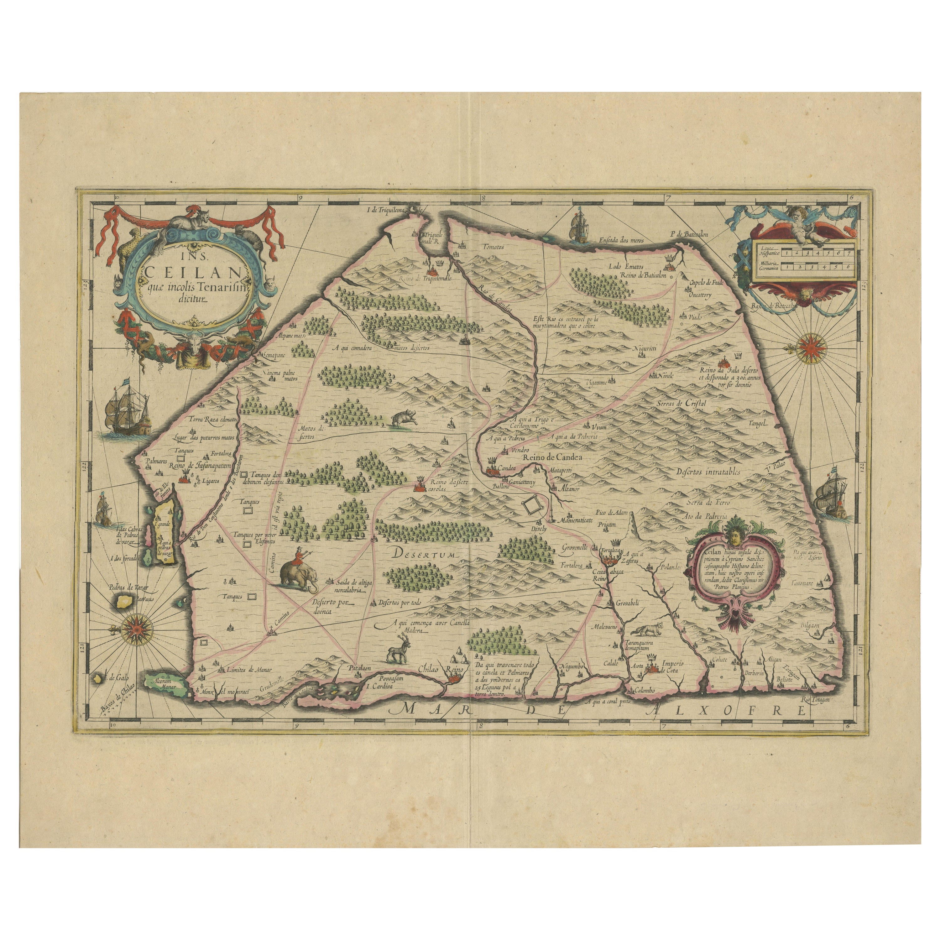
1638 Plancius Detailed Map of Sri Lanka or Ceylon with Decorative Cartouches
Located in Langweer, NL
"1638 Plancius Detailed Map of Sri Lanka with Decorative Cartouches"
This beautifully detailed map of Sri Lanka, titled "Ins. Ceilan," was engraved by P. Plancius from a design by C...
Category
Antique 1630s Maps
Materials
Paper
$1,380 Sale Price
20% Off
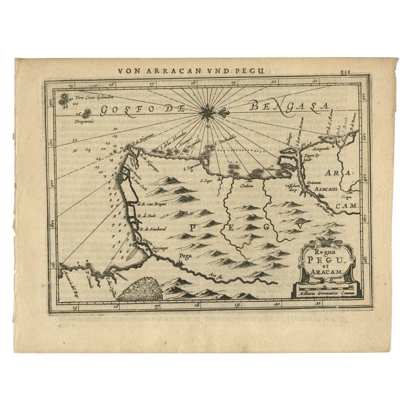
Antique Map of Myanmar titled 'Regna Pegu et Aracam by Mapmaker Janssonius, 1651
Located in Langweer, NL
Antique map titled 'Regna Pegu et Aracam'. Beautiful map of part of Myanmar from Jansson's edition of Mercator's Atlas Minor. North to the right of map. Artists and Engravers: Johann...
Category
Antique 17th Century Maps
Materials
Paper
$431 Sale Price
20% Off
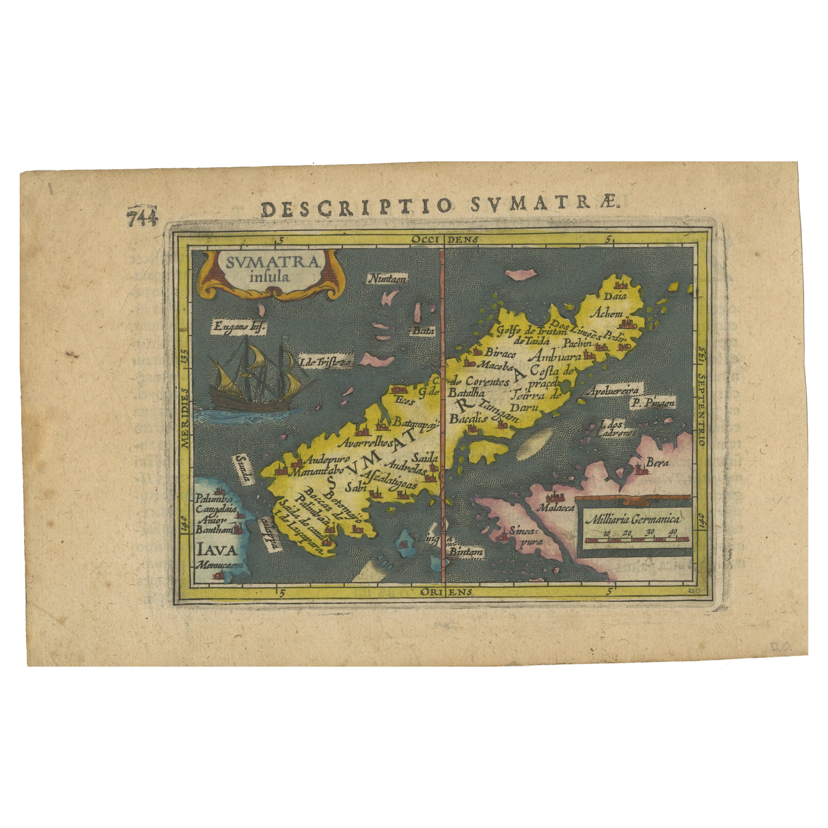
1616 Bertius Map of Sumatra, Singapore and the Straits of Malacca
Located in Langweer, NL
Title: "1616 Bertius Map of Sumatra and the Straits of Malacca"
Description: This is an exquisite 1616 original antique map by Petrus Bertius, titled "Sumatra Insula," showcasing Su...
Category
Antique Early 17th Century Maps
Materials
Paper

$805 Sale Price
20% Off
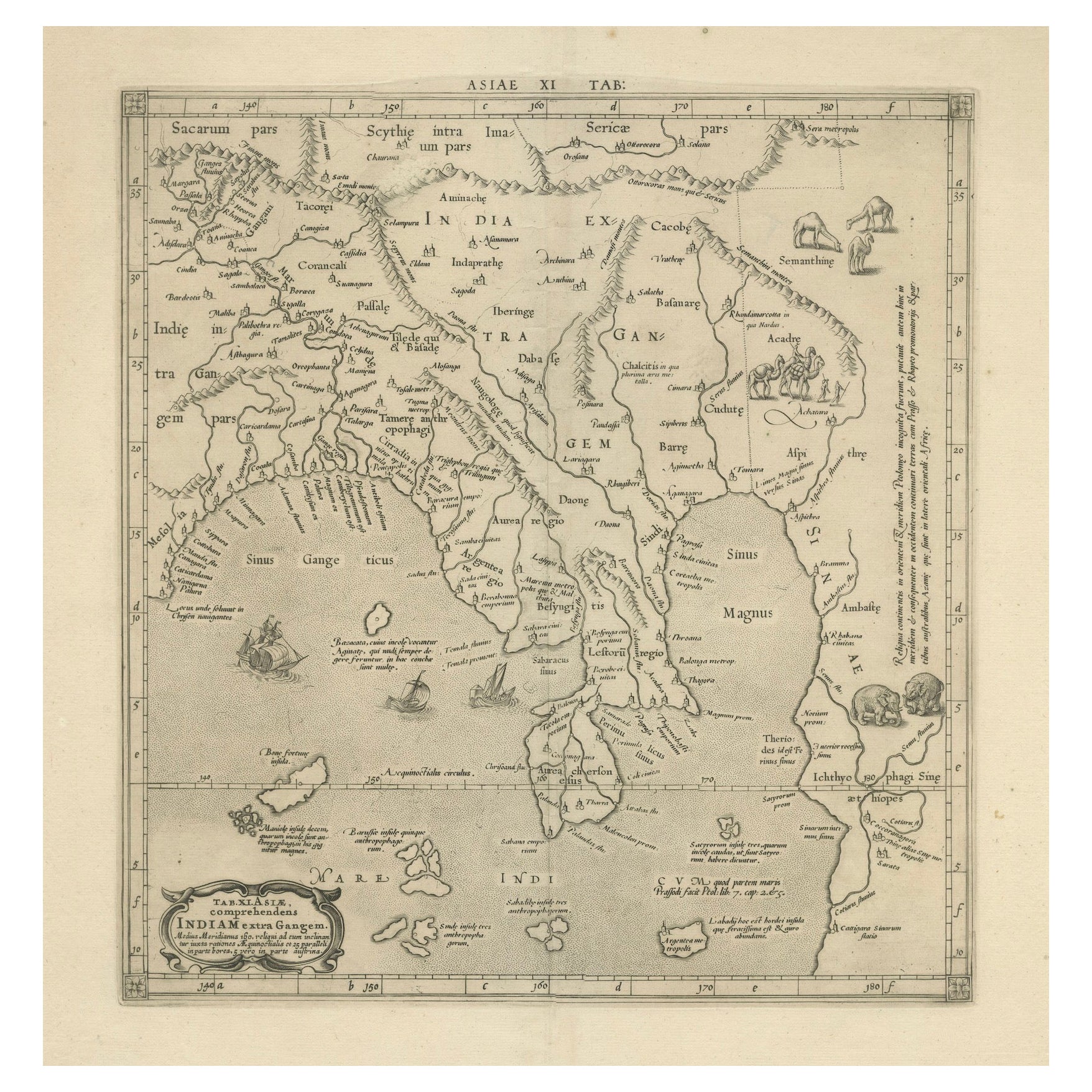
1698 Mercator Ptolemaic Map of Asia East of the Ganges
Located in Langweer, NL
**Catalogue Description:**
**Title:** Tab. XI. Asiae, comprehendens Indiam extra Gangem.
**Description:**
This is an exquisite Ptolemaic map depicting Asia east of the Ganges, ti...
Category
Antique 1680s Maps
Materials
Paper

$901 Sale Price
20% Off
Old Ptolemaic Map of the Region Between the Persian Gulf and Caspian Sea, 1598
Located in Langweer, NL
"Tabula Asiae V", Ptolemy/Ruscelli
Subject: Persia - Iran
Period: 1598 (published)
Publication: Geografia di Claudio Tolomeo Allessadrino…
Claudius Ptolemy was a mathematician, ast...
Category
Antique 16th Century Maps
Materials
Paper
$383 Sale Price
20% Off
You May Also Like
1592 Abraham Ortelius Map "Lorraine: Lotharingiae Nova Descripti, Ric.A005
Located in Norton, MA
1592 Abraham Ortelius map entitled
"Lorraine: Lotharingiae Nova Descripti
Ric.a005
Description: Ortelius is best known for producing the atlas from which this map comes from, "...
Category
Antique 16th Century Dutch Maps
Materials
Paper

1627 Hendrik Hondius Map Entitled "Vltoniae Orientalis Pars, " Ric.a009
Located in Norton, MA
1627 Hendrik Hondius map entitled
"Vltoniae orientalis pars,"
Ric.a009
Title:
Vltoniae orientalis : pars
Title (alt.) :
Ultoniae orientalis pars
Creator:
Mercator, Gerh...
Category
Antique 17th Century Dutch Maps
Materials
Paper

Antique French Map of Asia Including China Indoneseia India, 1783
Located in Amsterdam, Noord Holland
Very nice map of Asia. 1783 Dedie au Roy.
Additional information:
Country of Manufacturing: Europe
Period: 18th century Qing (1661 - 1912)
Condition: Overall Condition B (Good Used)...
Category
Antique 18th Century European Maps
Materials
Paper

$648 Sale Price
20% Off
Antique 1803 Italian Map of Asia Including China Indoneseia India
Located in Amsterdam, Noord Holland
Antique 1803 Italian Map of Asia Including China Indoneseia India
Very nice map of Asia. 1803.
Additional information:
Type: Map
Country of Manufacturing: Europe
Period: 19th centu...
Category
Antique 19th Century European Maps
Materials
Paper

$584 Sale Price
20% Off
1590 Mercator Map Entitled "France Picardie Champaigne, Ric.0001
Located in Norton, MA
Description: Published in Amsterdam by Mercator/Hondius ca. 1590.
Ric.0001
Artists and Engravers: Map : 'France Picardie Champaigne cum regionibus adiacentibus'. (Map of the french provinces of Picardie and Champagne.) Copper engraved map of the french provinces of Picardie and Champagne, showing the cities of Caen, Paris, Melun, Auxerre, Verdun, etc. Copperplate engraving on verge type hand laid paper with watermark. Description: Published in Amsterdam by Mercator/Hondius ca. 1600.Artists and Engravers: Mercator was born in Rupelmonde in Flanders and studied in Louvain under Gemma Frisius, Dutch writer, astronomer and mathematician. The excellence of his work brought him the patronage of Charles V, but in spite of his favor with the Emperor he was caught up in the persecution of Lutheran protestants and charged with heresy, fortunately without serious consequences. No doubt the fear of further persecution influenced his move in 1552 to Duisburg, where he continued the production of maps, globes and instruments. Mercator's sons and grandsons, were all cartographers and made their contributions in various ways to his atlas. Rumold, in particular, was responsible for the complete edition in 1595. The map plates...
Category
Antique 16th Century Dutch Maps
Materials
Paper

1633 Map Entitled "Beauvaisis Comitatus Belova Cium, Ric.0002
Located in Norton, MA
1633 map entitled
"Beauvaisis Comitatus Belova Cium,"
Hand Colored
Ric.0002
Description: Cartographer : - Hondius, Henricus 1587-1638
Artists and Engravers:Jodocus Hondius, one of the most notable engravers of his time. He is known for his work in association with many of the cartographers and publishers prominent at the end of the sixteenth and the beginning of the seventeenth century. A native of Flanders, he grew up in Ghent, apprenticed as an instrument and globe maker and map engraver. In 1584, to escape the religious troubles sweeping the Low Countries at that time, he fled to London where he spent some years before finally settling in Amsterdam about 1593. In the London period he came into contact with the leading scientists and geographers of the day and engraved maps in The Mariner\\\\\\\\\\\\\\\'s Mirrour, the English edition of Waghenaer\\\\\\\\\\\\\\\'s Sea Atlas, as well as others with Pieter van den Keere, his brother-in-law. No doubt his temporary exile in London stood him in good stead, earning him an international reputation, for it could have been no accident that Speed chose Hondius to engrave the plates for the maps in The Theatre of the Empire of Great Britaine in the years between 1605 and 1610. In 1604 Hondius bought the plates of Mercator\\\\\\\\\\\\\\\'s Atlas which, in spite of its excellence, had not competed successfully with the continuing demand for the Ortelius Theatrum Orbis Terrarum. To meet this competition Hondius added about 40 maps to Mercator\\\\\\\\\\\\\\\'s original number and from 1606 published enlarged editions in many languages, still under Mercator\\\\\\\\\\\\\\\'s name but with his own name as publisher. These atlases have become known as the Mercator/Hondius series. The following year the maps were reengraved in miniature form and issued as a pocket Atlas Minor. After the death of Jodocus Hondius the Elder in 1612, work on the two atlases, folio and miniature, was carried on by his widow and sons, Jodocus II and Henricus, and eventually in conjunction with Jan Jansson in Amsterdam.
In all, from 1606 onwards, nearly 50 editions with increasing numbers of maps with texts in the main European languages were printed. Summaries of these issues are given under the entry for Gerard Mercator. Jodocus Hondius the Elder * 1588 Maps in The Mariner\\\\\\\\\\\\\\\'s Mirrour (Waghenaer/Ashley) * 1590 World Map...
Category
Antique 17th Century Dutch Maps
Materials
Paper

More Ways To Browse
Leather Pouf And Ottomans
Low Side Tables
Set Of Four Italian Dining Chairs
Silk Runner Carpet
3x5 Rugs
Italian Lacquer Dining Room Sets
Round Brass Table
Round Table Base
Belgian Antiques
Cream Soup
Early English Silver
James Bond
Paisley Rugs and Carpets
Antique Pagoda
Black And Chrome Lounge Chair
Ceramic 1960s Italy
Vintage 1930 Dining Room Set
Antique Brass And Copper