Items Similar to 1629 Historic Miniature Map of Batavia (Jakarta) - Dutch Colonial Era

Want more images or videos?
Request additional images or videos from the seller
1 of 7
1629 Historic Miniature Map of Batavia (Jakarta) - Dutch Colonial Era
About the Item
An original490 historic map or bird's-eye view of Batavia (now Jakarta) as it was in the year 1629. Batavia was the name given to the city by the Dutch during their colonization of what is now Indonesia.
The map is detailed and colored, showing the layout of the city with its defensive walls, buildings, and the surrounding landscape, which includes areas of cultivation and ships in the nearby waters, suggesting the city's role as a significant trading port at the time. Remains are still there in the old harbour nowadays called Sunda Kelapa.
Maps like this were often part of larger atlases or records of territories held by European powers during the colonial period. They served both as practical guides for navigation and governance and as demonstrations of the extent of a nation's overseas territories.
The detail on the map, from the individual buildings to the ships, indicates the importance of Batavia as a colonial hub. The presence of fortifications suggests the strategic and commercial significance of the location. This map would be of interest to historians, geographers, and collectors due to its historical context, the quality of the cartographic detail, and the fact that it represents a specific moment in the colonial history of Southeast Asia.
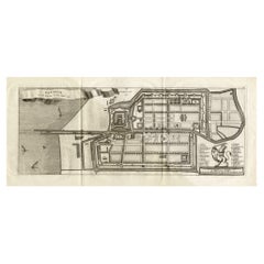
Antique map Batavia by Argensola titled ‘BATAVIA l’An 1629′.
A small early 18th century oblique black and white French plan of Batavia as it was in 1629 by Bartholome Juan Leonardo y Argensola (1562 – 1631), Spanish poet and historian and published by Jacques Desbordes in Histoire de la conquete des isles Moluques par les Espangnols, par les Portugais, & par les Hollandois in Amsterdam in 1706 (Brommer, BAT K06, p.29). The Conquest of the Moluccas, Madrid, Alonso Martin, 1609. 409 pp. was the most famous historical work of this author abroad. Translated into French (Histoire des isles of conquête Moluques par espagnols them, par les portugais et par les hollandois), and published in Amsterdam by Jacques Desbordes, in 3 volumes in 1706.); An English translation by John Stevens, “The discovery and conquest of the Philippine Islands and Molucco” in A new collection of voyages and travels, was published in London in 1708 in one volume by J. Knapton, with a reissue in 1711 and a German edition ( Beschreibung der Molukischen Insuln) in Frankfurt, M. Rohrlach, 1710, and Continuation der Beschreibung der Molukischen Insuln, 1711, reprinted in 1781).
Artist: Bartholome Juan Leonardo y Argensola
Year: 1629
More research needs to be done, but this map is possible published by Renneville in 1705.
- Dimensions:Height: 5.91 in (15 cm)Width: 7.68 in (19.5 cm)Depth: 0 in (0.02 mm)
- Materials and Techniques:Paper,Engraved
- Period:
- Date of Manufacture:1705
- Condition:Good. Later hand-coloring. Few flattened folding lines. Please study the image carefully.
- Seller Location:Langweer, NL
- Reference Number:Seller: BG-13468-11stDibs: LU3054337747572
About the Seller
5.0
Recognized Seller
These prestigious sellers are industry leaders and represent the highest echelon for item quality and design.
Platinum Seller
Premium sellers with a 4.7+ rating and 24-hour response times
Established in 2009
1stDibs seller since 2017
2,434 sales on 1stDibs
Typical response time: 1 hour
- ShippingRetrieving quote...Shipping from: Langweer, Netherlands
- Return Policy
Authenticity Guarantee
In the unlikely event there’s an issue with an item’s authenticity, contact us within 1 year for a full refund. DetailsMoney-Back Guarantee
If your item is not as described, is damaged in transit, or does not arrive, contact us within 7 days for a full refund. Details24-Hour Cancellation
You have a 24-hour grace period in which to reconsider your purchase, with no questions asked.Vetted Professional Sellers
Our world-class sellers must adhere to strict standards for service and quality, maintaining the integrity of our listings.Price-Match Guarantee
If you find that a seller listed the same item for a lower price elsewhere, we’ll match it.Trusted Global Delivery
Our best-in-class carrier network provides specialized shipping options worldwide, including custom delivery.More From This Seller
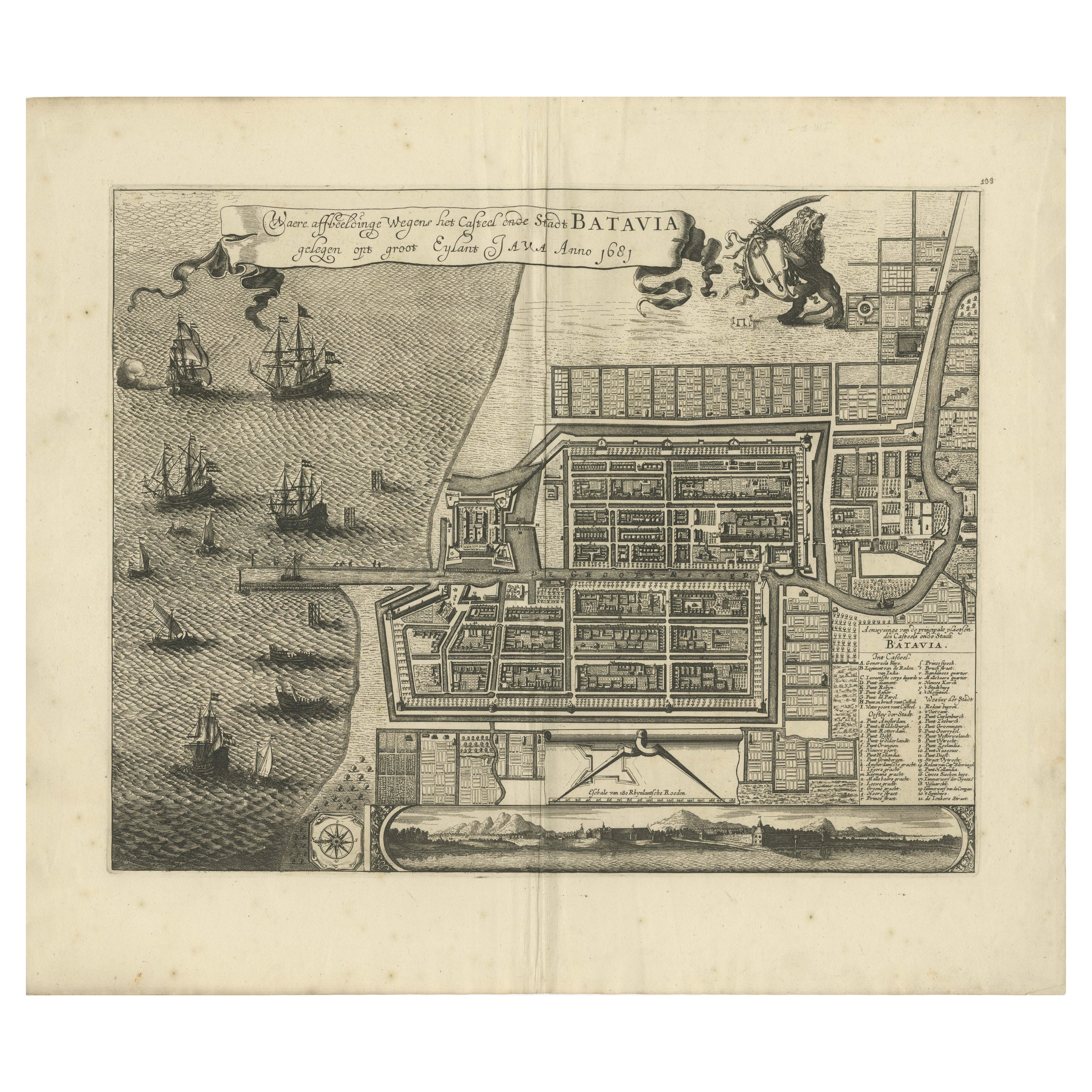
View AllRare 1681 Map of Batavia: Detailed Dutch Colonial Era Cartography, 1681
Located in Langweer, NL
The map of Batavia (modern-day Jakarta) from 1681, attributed to Frederick de Wit holds significant historical importance for several reasons:
Historical Context
1. Colonial Era: This map dates back to the Dutch colonial era when Batavia served as the administrative and commercial hub of the Dutch East India Company (VOC). The VOC was a powerful trading entity that played a crucial role in the global spice trade and colonization in Southeast Asia.
2. Strategic Importance: Batavia was strategically located on the northwestern coast of Java, providing the Dutch with a critical base for their maritime operations. The city became the center of Dutch political and military control in the region.
Cartographic Significance
1. Detailed Urban Layout: The map meticulously details the layout of Batavia, including its fortifications, canals, streets, and significant buildings. This level of detail provides insights into the urban planning and architectural styles of the period.
2. Military Engineering: The fortifications shown on the map illustrate the advanced military engineering techniques used by the Dutch to protect their valuable colony. The walls, bastions, and moats indicate the strategic considerations taken to defend against potential invasions.
3. Maritime Activity: The depiction of ships in the harbor highlights Batavia's role as a major maritime center. The VOC's fleets were essential for trade routes connecting Europe, Africa, and Asia, making Batavia a crucial node in global commerce.
Artistic and Cultural Value
1. Artistic Elements: The decorative elements, such as the lion holding a shield and the intricate cartouches, reflect the artistic trends of Dutch Golden Age cartography. These embellishments were not only informative but also served to display the cartographer's skill and the map's prestige.
2. Cultural Exchange: Maps like this one provide evidence of cultural exchange between the Dutch and the indigenous populations of Java. The blending of Dutch and local influences can be seen in various aspects of the map and the architecture of the city.
Rarity and Preservation
1. Rarity: Maps from the 17th century, especially those in good condition, are relatively rare and highly valued by collectors and historians. Each map provides a unique snapshot of historical geography and urban development.
2. Preservation of History: This map serves as a historical document, preserving knowledge about Batavia's cityscape, infrastructure, and colonial governance. It helps historians and scholars understand the socio-economic and political dynamics of the period.
Conclusion
The map of Batavia from 1681 is special due to its detailed depiction of one of the most important colonial cities in Southeast Asia during the Dutch Golden Age. It reflects the strategic, economic, and cultural significance of Batavia, serving as a valuable resource for understanding the history of Dutch colonialism and its global impact. The map's artistry and precision make it an important artifact in the history of cartography.
---------------
The map is an original and historical map of Batavia (present-day Jakarta) on the island of Java, dated 1681. There are several details to consider when evaluating its origins and possible authorship:
1. **Style and Detail**: The intricate details and style are reminiscent of maps created by Frederick de Wit, a prominent Dutch cartographer and engraver of the 17th century. He was known for his detailed city maps and sea charts.
2. **Lack of Signature**: The absence of "F. de Wit, Excudit" could indicate either an omission or a different engraver. However, it is essential to note that some maps from that period were reproduced or copied by other engravers and cartographers. This was not uncommon, as map-making was a collaborative effort, and copies of popular maps were frequently made.
3. **Map Characteristics**:
- The depiction of ships and the detailed fortifications are typical of Dutch cartography in the late 17th century.
- The decorative elements, such as the lion holding a shield, are also characteristic of Dutch map engravers.
4. **Other Possible Engravers**: While Frederick de Wit is a strong candidate, other notable Dutch engravers from that period include Joan Blaeu and Willem Janszoon Blaeu. They also produced highly detailed maps and could potentially be the creators or inspirers of this map.
To determine the precise authorship, you might consider:
- **Comparing** this map with other confirmed works of Frederick de Wit and his contemporaries to identify stylistic similarities and differences.
- **Historical Records**: Consulting historical records or publications related to Dutch cartography in the 17th century might provide more context or even direct references to this particular map.
If you have access to additional details or higher-resolution images of specific sections, it might help further pinpoint the map's origin and authorship.
-------------
Frederick de Wit (1629–1706) was a prominent Dutch cartographer, engraver, and publisher known for his detailed and decorative maps, atlases, and globes. He played a significant role in the Dutch Golden Age of cartography, contributing to the wealth of geographic knowledge and artistic achievement during this period. Here are key aspects of his life and work:
### Biography
- **Early Life**: Frederick de Wit was born in Gouda, Netherlands, in 1629. Little is known about his early years, but he moved to Amsterdam, the epicenter of Dutch cartography, in the mid-17th century.
- **Career Beginnings**: De Wit began his career as an engraver and publisher, initially producing maps that were reissues of earlier works by other cartographers, such as Joan Blaeu and Willem Janszoon Blaeu.
### Contributions to Cartography
- **Mapmaking**: De Wit was known for his meticulous attention to detail and artistic flair. He produced a wide range of maps, including world maps, regional maps, city plans, and maritime charts...
Category
Antique 1680s Maps
Materials
Paper

$5,473 Sale Price
20% Off
Free Shipping
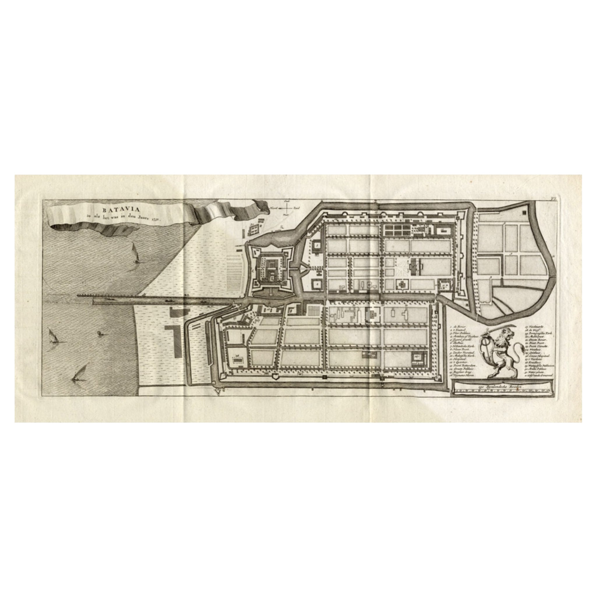
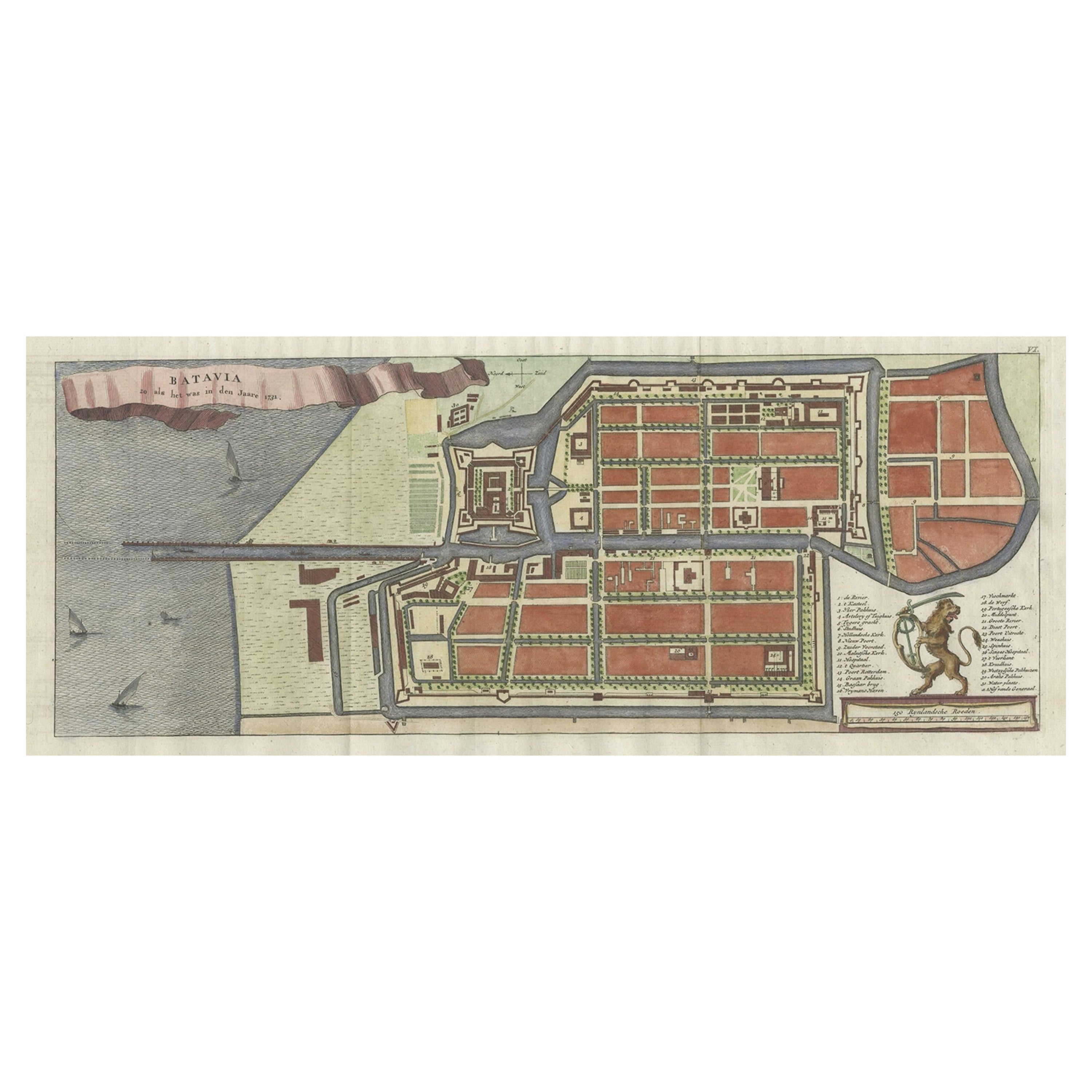
Antique Map of Batavia 'Jakarta, Indonesia', the Dutch East-Indies, 1782
Located in Langweer, NL
Antique map titled 'Batavia zo als het was in den Jaare 1731.' (Batavia as it was in the year 1731.) Map of the city of Batavia (Jakarta) in Indonesia. With legend and scale. This pr...
Category
Antique 18th Century Maps
Materials
Paper
$593 Sale Price
20% Off
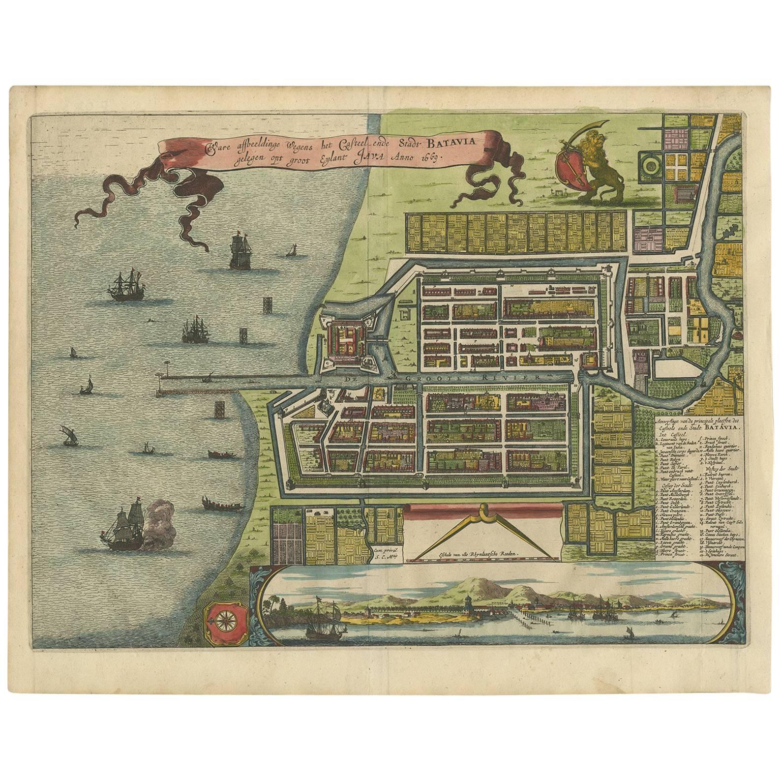
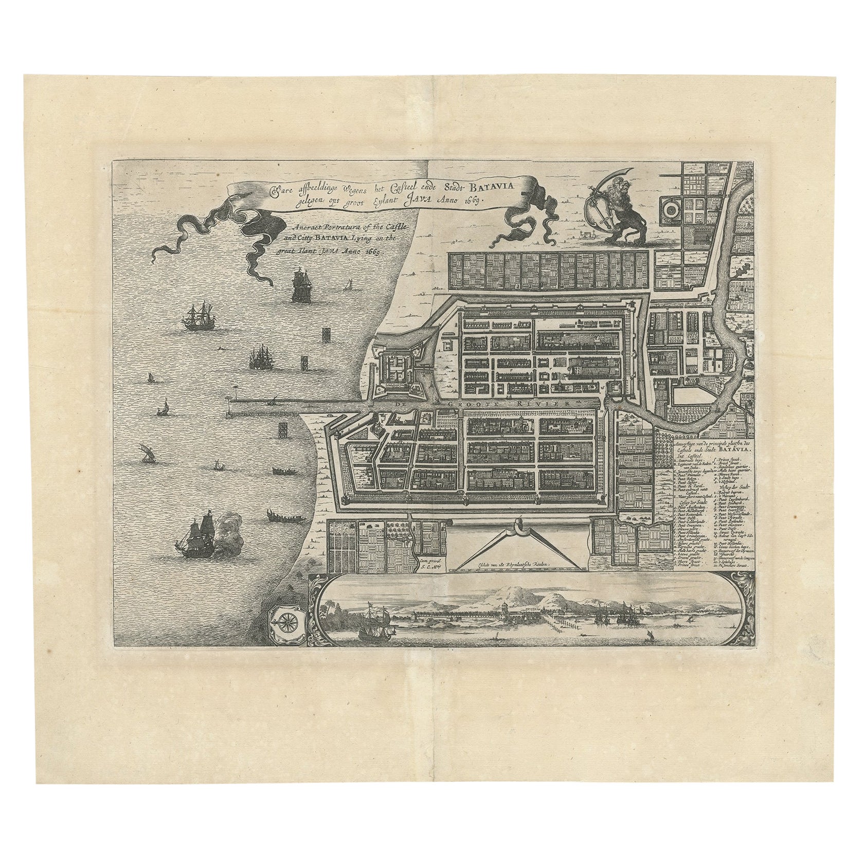
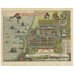
Antique Map of Batavia, Dutch East Indies, Nowadays Jakarta, Indonesia, ca.1669
Located in Langweer, NL
Antique map titled 'Ware afbeeldinge wegens het Casteel ende Stadt Batavia gelegen opt groot Eylant Java Anno 1679. Plan de la Ville et du Chateau de Batavia en l'Isle de Iava. 1679....
Category
Antique 1660s Maps
Materials
Paper

$1,252 Sale Price
20% Off
Antique Map of Batavia 'Jakarta, Indonesia' by Montanus, 1679
Located in Langweer, NL
Fine early plan of Batavia (Jakarta), published by Arnoldus Montanus. This map has a vignette at the bottom showing Jakarta from the sea with the volcanoes Mount Gede, Mount Pangrnago and Mount Salak in the background. The plan is based on the earlier, much larger map of Batavia published by Clement de Jonghe...
Category
Antique Late 17th Century Unknown Maps
Materials
Paper
$988 Sale Price
20% Off
Antique Map of Batavia 'Jakarta', Indonesia by Montanus, circa 1669
Located in Langweer, NL
Antique map Batavia titled 'Ware Affbeeldinge wegens het Casteel ende Stadt Batavia'. Antique print of the castle and city of Batavia on the Island of Java'. Rare edition with Englis...
Category
Antique 17th Century Maps
Materials
Paper

$1,159 Sale Price
20% Off
Antique Map of Batavia, Nowadays Jakarta, the Capital of Indonesia, 1782
Located in Langweer, NL
Antique map Batavia titled 'Batavia zo als het was in den Jaare 1731'. Old map of the city of Batavia (Jakarta) in Indonesia. Originates from 'Batavia, de Hoofdstad van Neerlands O. ...
Category
Antique 18th Century Maps
Materials
Paper

$881 Sale Price
20% Off
You May Also Like
Late Victorian Era Miniature Croquet Set
Located in Oakland, CA
A wonderful antique miniature croquet set consisting of multiple mallets, wickets and balls, all housed in the original wooden box. A charming and unusual piece of English whimsical ...
Category
Antique Early 1900s English Late Victorian Toys and Dolls
Materials
Metal
Colonial Era Hand Carved Wooden Horse and Rider
Located in Los Angeles, CA
early 19thc hand carved wooden colonial era horse and rider. beautiful patina and age to this piece. The fading of color is expected over the time that is has been made. Wear is cons...
Category
Antique Early 19th Century American Adirondack Models and Miniatures
Materials
Wood
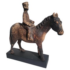
$1,516 Sale Price
20% Off
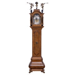
Miniature Dutch Walnut Long Case Clock
By Jan Henkels
Located in Den Haag, NL
Love this miniature Dutch walnut long case clock. Not only great looking but also a good working
time piece. Comes with a good quality watch. M...
Category
Vintage 1950s Dutch Baroque Models and Miniatures
Materials
Walnut
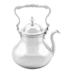
Dutch Silver Miniature Kettle - Antique 1706
Located in Jesmond, Newcastle Upon Tyne
This exceptional, fine and impressive antique 18th century Dutch silver miniature tea kettle has a circular baluster shaped form.
The body of this silver kettle is plain and unembellished, with an applied border to the upper rim.
This antique silver kettle is fitted with a push fit domed cover surmounted with a cast silver baluster shaped finial.
The kettle is fitted with a fine and impressive hinged cast scrolling handle.
This exceptional miniature silver tea kettle features a plain cast silver swan-necked spout.
The hallmarks struck to the underside of this Dutch silver kettle include:
National mark: Crowned shield with three Andrew crosses (Amsterdam, minimum of .875 standard)
Date letter: T (1706)
Maker's mark: Untraced
Such period miniature examples of this substantial gauge of silver and quality are rare to the market.
Maker: Unknown
Condition
This 18th century kettle...
Category
Antique Early 18th Century Dutch Models and Miniatures
Materials
Silver
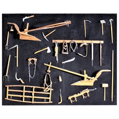
Midcentury Era Folk Art Made Collection of Miniature Antique Farm Implements
Located in Hamilton, Ontario
This framed collection of over two dozen handcrafted miniature antique farm implements are all unsigned, but presumed to have been made in Canad...
Category
Mid-20th Century Canadian Folk Art Models and Miniatures
Materials
Leather, Softwood
Japanese Sculpture Okimono of a Dutchman, Dutch Colonial, 18th Century
Located in Amsterdam, NL
An extremely rare wood Japanese Okimono of a Dutchman playing with a bat
Edo period, 18th-19th century or earlier
The Dutchman is standing and h...
Category
Antique Early 18th Century Japanese Edo Sculptures and Carvings
Materials
Boxwood
Recently Viewed
View AllMore Ways To Browse
Silver Plate Art Deco Cocktail Shaker
Small Dining Table With Extension
Square Club Chair
Sterling Condiment
Sugar Creamer Tray
Swivel Ottomans
Tavolino Coffee Table
Three Seat Leather Danish Sofa
Tooled Leather Chairs
Trestle Chair
Trophy Silver Cup
Turkish Textile Framed
Tweed Upholstery
Twist Pedestal Table
Vintage 1950s Hat
Vintage Limestone Table
Vintage Louis Vuitton Trunks
Vintage Rattan Tray