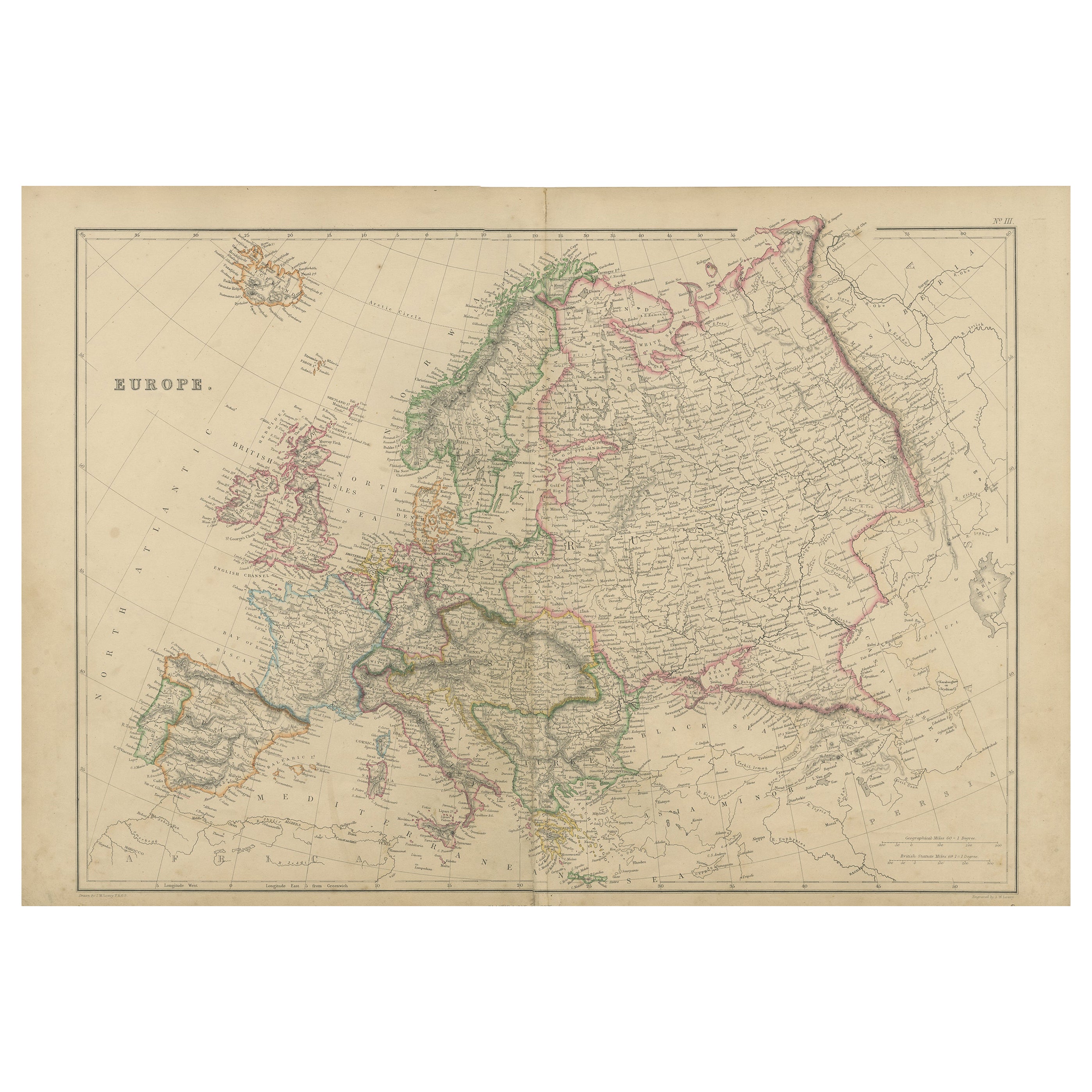
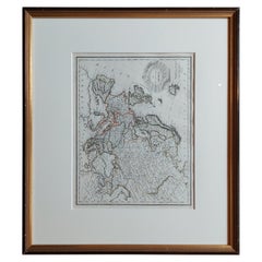
1674 Map of Europe
View Similar Items


Want more images or videos?
Request additional images or videos from the seller
1 of 11
1674 Map of Europe
About the Item
- Dimensions:Height: 35 in (88.9 cm)Width: 46.5 in (118.11 cm)
- Place of Origin:
- Period:
- Date of Manufacture:17th c.
- Condition:In very good overall condition.
- Seller Location:Milford, NH
- Reference Number:Seller: 25991stDibs: U120602933956
About the Seller
4.9
Platinum Seller
Premium sellers with a 4.7+ rating and 24-hour response times
Established in 1983
1stDibs seller since 2012
302 sales on 1stDibs
Authenticity Guarantee
In the unlikely event there’s an issue with an item’s authenticity, contact us within 1 year for a full refund. DetailsMoney-Back Guarantee
If your item is not as described, is damaged in transit, or does not arrive, contact us within 7 days for a full refund. Details24-Hour Cancellation
You have a 24-hour grace period in which to reconsider your purchase, with no questions asked.Vetted Professional Sellers
Our world-class sellers must adhere to strict standards for service and quality, maintaining the integrity of our listings.Price-Match Guarantee
If you find that a seller listed the same item for a lower price elsewhere, we’ll match it.Trusted Global Delivery
Our best-in-class carrier network provides specialized shipping options worldwide, including custom delivery.More From This Seller
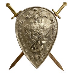
View AllClassical Revival Pair of Ceremonial Swords & Shield
Located in Milford, NH
A fine pair of Classical Revival ceremonial swords with brassed handles, attached to a pressed steel shield with nickel plating featuring classical, angelic and military figures, som...
Category
Early 20th Century European Arms, Armor and Weapons
Materials
Metal, Steel
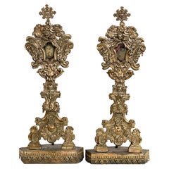
Large Pair of 18th / 19th Century Italian Silvered Reliquaries
Located in Milford, NH
A fine large pair of Italian silvered metal over wood reliquaries with putti, grape, shell, and scrollwork design. Each have memorial pendant displays with names (The left reads S. Innocentii M & S Clementiani M,” while the other is illegible. The pair is in very good condition, with great overall patina, some metal lifting...
Category
Antique Late 18th Century Italian Baroque Religious Items
Materials
Metal
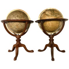
Pair of 19th Century English J & W Cary Celestial/Terrestrial Table Model Globes
By John & William Cary
Located in Milford, NH
A fine assembled pair of 12-inch English table model globes on stands manufactured by J & W. Cary, the left globe with cartouche labeled “The New Celestial Globe, on which are correc...
Category
Antique Early 19th Century English Globes
Materials
Brass
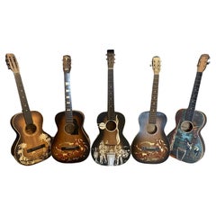
Group of Five Cowboy Acoustic Guitars Including Gene Autry Melody Ranch c 1940's
Located in Milford, NH
A fun collection of mid century acoustic cowboy guitars, including two Gene Autry Melody Ranch models, circa 1940’s, some unsigned, and one hand painted with “The Plainsman” on the p...
Category
Vintage 1940s American Musical Instruments
Materials
Metal
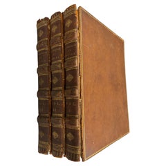
Rare 3 Vol. Book Set, Microcosm of London or London in Miniature by Ackerman
Located in Milford, NH
A rare leatherbound three volume book set titled “Microcosm of London or London in Miniature” published by Rudolph Ackerman (1764 - 1834), illustrated with 104 aquatint plates after ...
Category
Antique Early 1800s English Books
Materials
Leather, Paper
Goodyear Panoramic Factory Print with Gouache by Woodbury & Co, Worcester MA
Located in Milford, NH
A finely detailed panoramic ink print with gouache of the Goodyear factory in the early 20th century done by Woodbury & Co, of Worcester, Massachusetts. This company was known for th...
Category
20th Century American Prints
Materials
Paper

You May Also Like
Antique Map of Northern Europe and European Russia, ca.1780
Located in Langweer, NL
Antique map titled 'Le Nord de L'Europe, Contenant Le Danemark, La Norwege; La Suede et La Laponie avec la Majeure Partie de al Russie Europeenne.'
Map of Northern Europe and Eur...
Category
Antique 1780s Maps
Materials
Paper

$176 Sale Price
20% Off
Original Antique Map of Europe, Arrowsmith, 1820
Located in St Annes, Lancashire
Great map of Europe
Drawn under the direction of Arrowsmith.
Copper-plate engraving.
Published by Longman, Hurst, Rees, Orme and Brown, 1820
...
Category
Antique 1820s English Maps
Materials
Paper

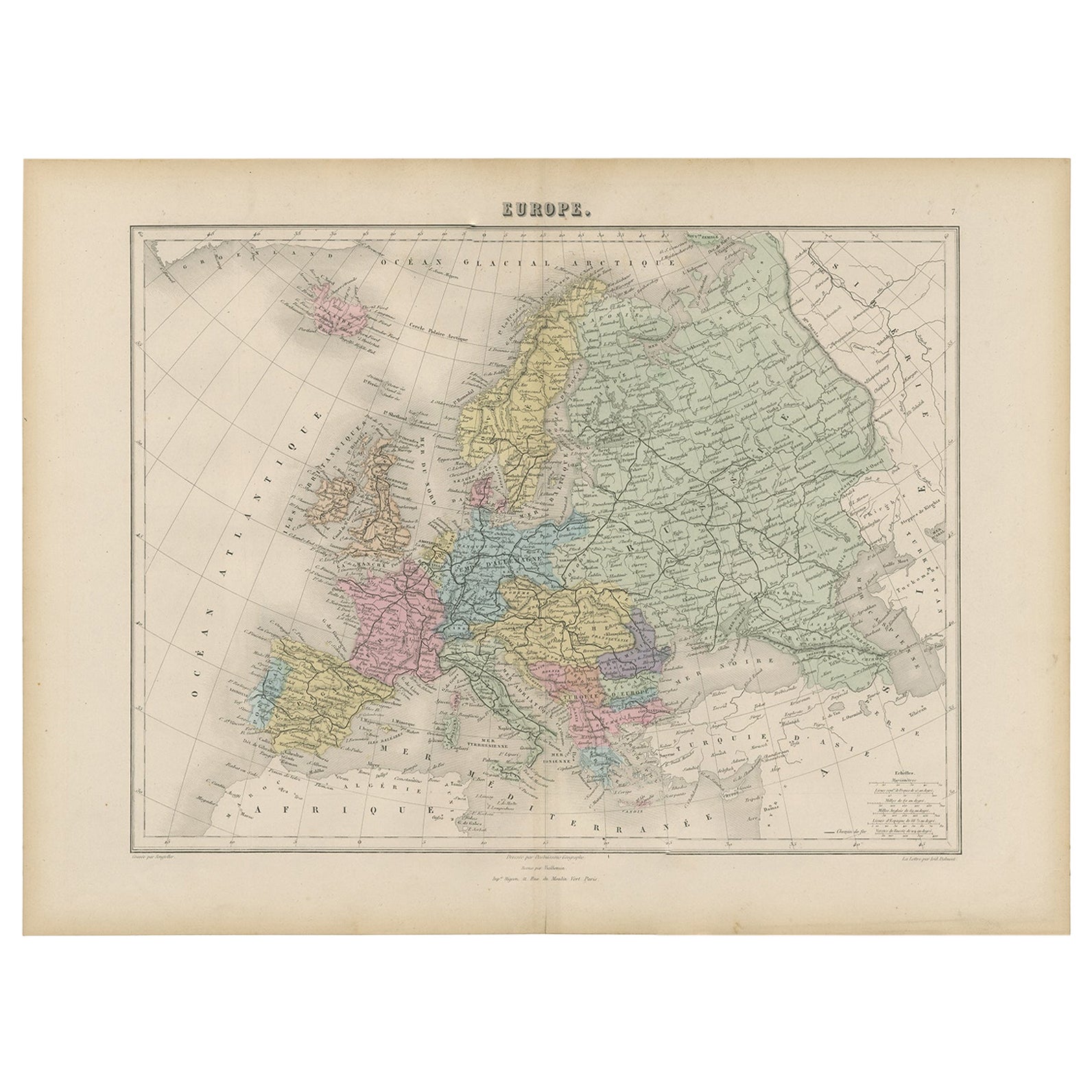
Antique Map of Europe by Levasseur, '1875'
Located in Langweer, NL
Antique map titled 'Carte générale de l'Europe'. Large map of Europe. This map originates from 'Atlas de Géographie Moderne Physique et Politique' by A. Levasseur. Published 1875.
Category
Antique Late 19th Century Maps
Materials
Paper

$348 Sale Price
40% Off
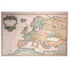
Antique Map of Europe by Lapie, '1809'
Located in Langweer, NL
Antique map titled 'Europe'. Original antique map of Europe by P. Lapie, published 1809. Frame included.
Category
Antique Early 19th Century Maps
Materials
Paper
$279 Sale Price
20% Off
Antique Map of Europe by Balbi '1847'
Located in Langweer, NL
Antique map titled 'Europe'. Original antique map of Europe. This map originates from 'Abrégé de Géographie (..)' by Adrien Balbi. Published 1847.
Category
Antique Mid-19th Century Maps
Materials
Paper

$139 Sale Price
20% Off
Antique Map of Europe by Johnson, '1872'
Located in Langweer, NL
Antique map titled 'Johnson's Europe'. Original map of Europe. This map originates from 'Johnson's New Illustrated Family Atlas of the World' by A.J. Johnson. Published 1872.
Category
Antique Late 19th Century Maps
Materials
Paper

$325 Sale Price
20% Off