Want more images or videos?
Request additional images or videos from the seller
1 of 2
1748 World Map "Essay D'un Carte Requite Du Globe Terrestre" by N. Bellin
Price:$3,300
$4,500List Price
About the Item
- Dimensions:Height: 29.5 in (74.93 cm)Width: 37.75 in (95.89 cm)Depth: 1.75 in (4.45 cm)
- Materials and Techniques:Paper,Engraved
- Period:1740-1749
- Date of Manufacture:1748
- Condition:Wear consistent with age and use.
- Seller Location:Colorado Springs, CO
- Reference Number:Seller: M1011stDibs: LU90974627383
About the Seller
4.9
Vetted Professional Seller
Every seller passes strict standards for authenticity and reliability
Established in 2010
1stDibs seller since 2011
465 sales on 1stDibs
Authenticity Guarantee
In the unlikely event there’s an issue with an item’s authenticity, contact us within 1 year for a full refund. DetailsMoney-Back Guarantee
If your item is not as described, is damaged in transit, or does not arrive, contact us within 7 days for a full refund. Details24-Hour Cancellation
You have a 24-hour grace period in which to reconsider your purchase, with no questions asked.Vetted Professional Sellers
Our world-class sellers must adhere to strict standards for service and quality, maintaining the integrity of our listings.Price-Match Guarantee
If you find that a seller listed the same item for a lower price elsewhere, we’ll match it.Trusted Global Delivery
Our best-in-class carrier network provides specialized shipping options worldwide, including custom delivery.You May Also Like
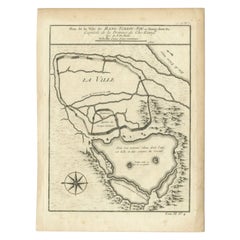
Antique Map of the City of Hangzhou by Bellin, 1748
By Jacques-Nicolas Bellin
Located in Langweer, NL
Antique map titled 'Plan de la ville de Hang-Tcheou-Fou ou Hang-Chew-Fu Capitale de la Province de Che-Kiang’. This original print shows a map of the city of Hangzhou, capital of the...
Category
Antique 18th Century Maps
Materials
Paper
Antique Map of the Cape of Good Hope by J.N. Bellin, 1748
Located in Langweer, NL
Early plan of the Cape of Good Hope, includng a town plan and illustrations of the fortificatons. This map originates from Tome V of Abbe Prevost's Histoire generale du voyages.
Category
Antique Mid-18th Century Maps
Materials
Paper
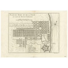
$330 Sale Price
20% Off
H 9.97 in W 14.02 in D 0.02 in
Antique Map of Si-Ngan-fu and Tchang Lan 'China' by Bellin '1748'
By Jacques-Nicolas Bellin
Located in Langweer, NL
Antique map China titled ‘Villes de la Province de Chensi’. Interesting set of two local town plans of "Si-Ngan-Fu: Capitale, Hoofdstad." and "Tchang...
Category
Antique Mid-18th Century Maps
Materials
Paper
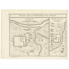
$143 Sale Price
20% Off
H 9.65 in W 13 in D 0.02 in
Antique Map: Carte du Détroit du Sond with Copenhagen Inset, 1693
Located in Langweer, NL
Antique Map: Carte du Détroit du Sond with Copenhagen Inset, Jaillot/Mortier, 1693
This rare and striking antique map, titled *Carte du détroit du Sond contenant les costes de l’Is...
Category
Antique Late 17th Century Maps
Materials
Paper
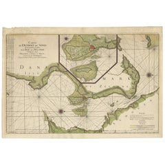
$2,157 Sale Price
20% Off
Free Shipping
H 25.79 in W 37.01 in D 0.02 in
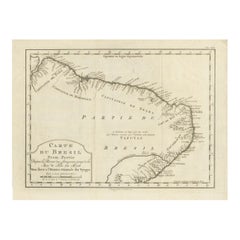
Brazil Coastline Map – Broenner Carte du Bresil, 1772 Captaincies
Located in Langweer, NL
Carte du Bresil Map, Broenner Krefeld 1772 – Brazil Coastline Captaincies
This is an engraved map titled Carte du Bresil Prem. Partie, published in Krefeld (Germany) by J.J. Broenne...
Category
Antique Late 18th Century French Maps
Materials
Paper
$485
H 11.03 in W 14.57 in D 0.01 in
Antique Map of Kamchatka by Bellin, '1757'
By Jacques-Nicolas Bellin
Located in Langweer, NL
Antique map titled 'Carte du Kamtchatka'. Antique map of the Kamchatka Peninsula. The map includes the island of Ouiakous Atch ou Anfinogen, Schoumctchou, and Sirinki ou Dilkon. Orig...
Category
Antique Mid-18th Century Maps
Materials
Paper
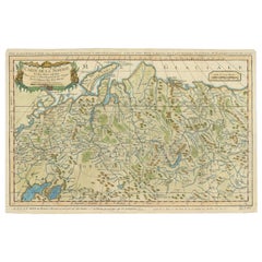
Antique Map of Siberia by Bellin, 1754
Located in Langweer, NL
Antique map titled 'Carte de la Siberie'. Detailed map of Siberia, extending from the White Sea and the Caspian Sea in the west to Irkuckoi Province, Jakutky on the Lena River and regions just to the east. Centered on the Jenisi River. Originates from Prévost's 'Histoire Générale des Voyages'. Artists and Engravers: Jacques-Nicolas Bellin (1703-1772) was among the most important mapmakers of the eighteenth century. In 1721, at age 18, he was appointed hydrographer (chief cartographer) to the French Navy. In August 1741, he became the first Ingénieur de la Marine of the Depot des cartes...
Category
Antique 18th Century Maps
Materials
Paper
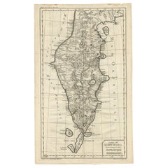
Antique Map of Sumatra by Bellin, 1764
Located in Langweer, NL
Antique map Sumatra titled 'Carte de l'Isle de Sumatra'. Old map of Sumatra, Malaysia and the Straits of Malacca, including Singapore. This map originates ...
Category
Antique 18th Century Maps
Materials
Paper

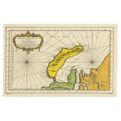
Antique Map of Novaya Zemlya by Bellin, 1758
Located in Langweer, NL
Antique map titled 'Partie de la Mer Glaciale Contenant la Nouvelle Zemle et le Pais des Samoiedes'. This map features Novaya Zemlya, the island off northern Russia in the Barents Se...
Category
Antique 18th Century Maps
Materials
Paper
Antique Map of Japan by J.N. Bellin, 1752
Located in Langweer, NL
Bellin's wonderfully detailed map of Japan from the atlas of Prevost d'Exiles' influential collection of travel narratives, Histoire Generale des Voyages. Considered the best general...
Category
Antique Mid-18th Century Maps
Materials
Paper

More From This Seller
View AllAntique Map of Paris, "Carte Routiere des Environs de Paris" 1841
Located in Colorado Springs, CO
This beautiful hand-colored road map of Paris was published in 1841. The map shows Paris and the surrounding area in a folding pocket map. Organized and detailed for travelers, this ...
Category
Antique 1840s French Maps
Materials
Paper

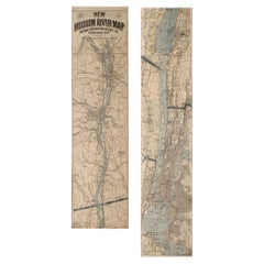
1917 "New Hudson River Map" by Wallace Bruce, Later Edition, Folding Map
Located in Colorado Springs, CO
Presented is a 1917 printing of “New Hudson Map” by Wallace Bruce. The map was published by Bryant Union Publishing Co., in New York City. The map is a later edition, issued in a distinct strip-chart format that is over 100 inches long. The map includes amazing detail, compiled mostly from U.S. Coast Survey data. It is drawn on a scale of 1.5 miles per inch, allowing ample space for it to show historical landmarks, landings, islands, list prominent residents, and more. The verso is filled with related text and illustrations about the Hudson River valley. The map folds into cream paper wrappers, titled "Hudson River Map...
Category
Vintage 1910s American Beaux Arts Maps
Materials
Paper
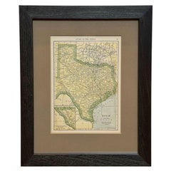
1927 "Texas" Map by C.S. Hammond
Located in Colorado Springs, CO
Presented is a very detailed map of Texas, printed in 1927. The map was featured in The Literary Digest Atlas of the World and Gazetteer, published by Funk & Wagnalls. The map is sma...
Category
Vintage 1920s American Maps
Materials
Paper
1870 "Johnson's World" by Prof. A. Guyot, Published by A. J. Johnson
Located in Colorado Springs, CO
Presented is an original "Johnson's World, Showing the Distribution of the Characteristic Forest Trees, Principal Useful Plants and Minerals" by Prof. A. Guyot. This map was issued a...
Category
Antique 1870s American Victorian Maps
Materials
Paper
1864 Map of North America, Antique Hand-Colored Map, by Adolphe Hippolyte Dufour
Located in Colorado Springs, CO
Offered is a map of North America entitled Amerique du Nord from 1864. This rare, separately published wall map was produced by Adolphe Hippolyte Dufour. This map includes vibrant an...
Category
Antique 1860s French Maps
Materials
Paper

1812 United States Map, by Pierre Tardieu, Antique French Map Depicting the U.S.
By Pierre François Tardieu
Located in Colorado Springs, CO
1812 "United States of Nth America -- Carte des Etats-Unis De L'Amerique Septentrionale" Two-Sheet Map by Tardieu
This attractive map, published in Paris in 1812, is one of the most rare large format maps from the period. It features a view of the East Coast of the U.S. from Maryland to just below South Carolina. Additionally, Ellicott’s plan for the City of Washington D.C. is included at the top right and an illustration of Niagara Falls is shown at the bottom right with a description in both French and English. This extremely detailed map not only depicts the mountainous regions of the southeastern U.S., but also includes names of regions, rivers, and towns.
Based on the first state of Arrowsmith’s 4-sheet map of the United States, this map is completely engraved by Tardieu in Paris and showcases high quality engravings. This detailed map of the recently independent United States includes one of the largest and earliest examples of the Ellicott plan of Washington DC.
The artist, Pierre François Tardieu (PF Tardieu) was a very well-known map engraver, geographer, and illustrator. Awarded a bronze medal by King Louis-Phillipe for the accuracy and beauty of his map-making, Tardieu produced many fine works including maps of Louisiana...
Category
Antique 1810s French Maps
Materials
Paper

Recently Viewed
View AllMore Ways To Browse
Sandwich Islands
Antique World Globes
1970 Italian Armchair
House Of Denmark Table And Chairs
Louis Marble Top Side Table
Antique Russian Rugs
Baker Furniture By
For Kids
Sterling Silver Flatware Set Service For 12
Tufted Bar
Pair Of French Antique Armchairs
1970s Brass Glass Coffee Table
Antique Column Base
Charles Rennie Mackintosh For Cassina
Glass Salt
Italian Modern Silver Vases
Vintage Resin Tables
Antique English Country Furniture