Items Similar to Southeastern Ireland: A 17th Century Hand Colored Map by Mercator and Hondius


Want more images or videos?
Request additional images or videos from the seller
1 of 8
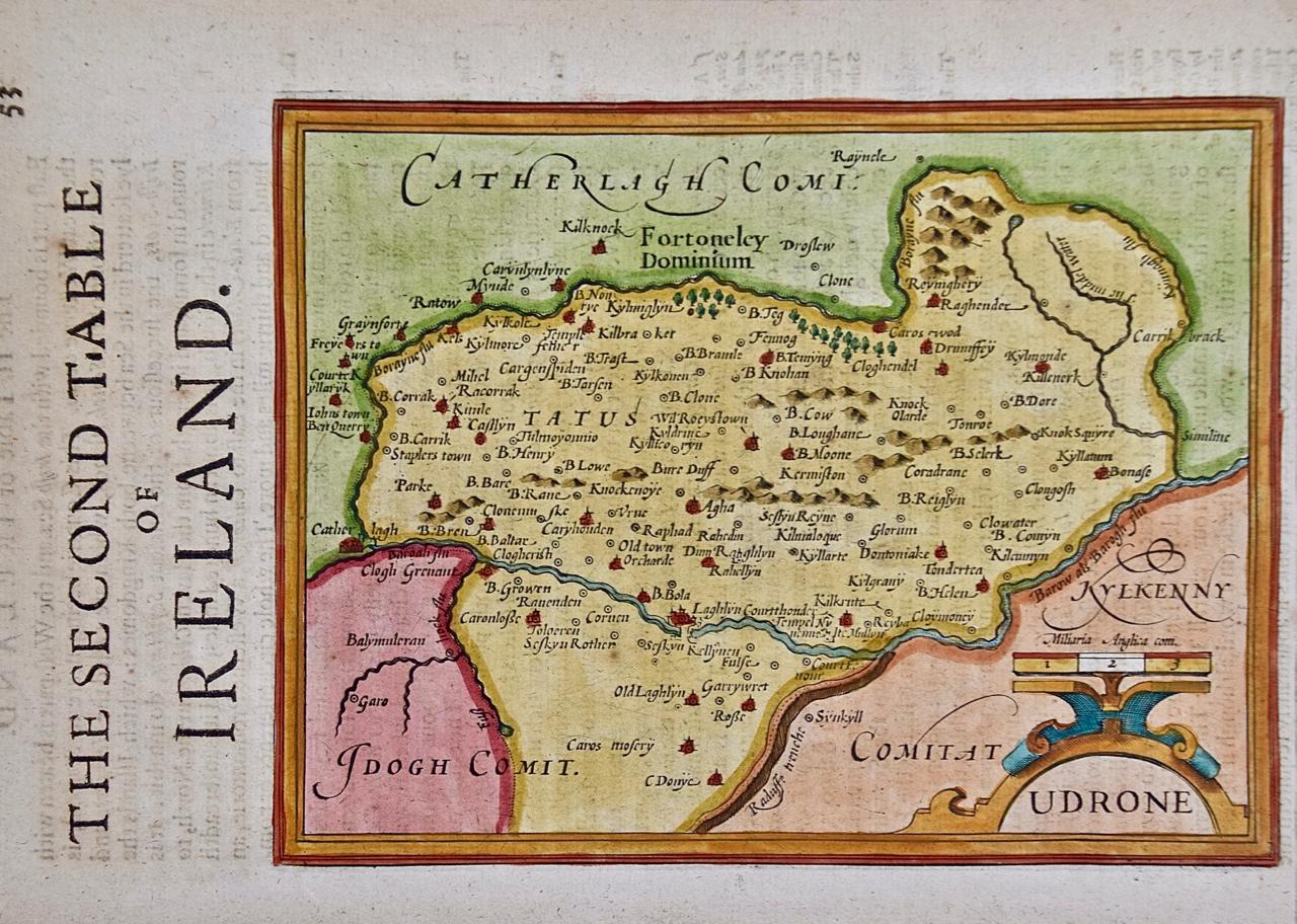
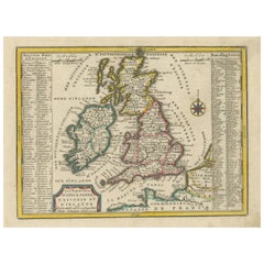
Southeastern Ireland: A 17th Century Hand Colored Map by Mercator and Hondius
$675
£500.88
€583.45
CA$939.60
A$1,046.33
CHF 544.56
MX$12,901.18
NOK 6,935.38
SEK 6,518.59
DKK 4,353.28
Shipping
Retrieving quote...The 1stDibs Promise:
Authenticity Guarantee,
Money-Back Guarantee,
24-Hour Cancellation
About the Item
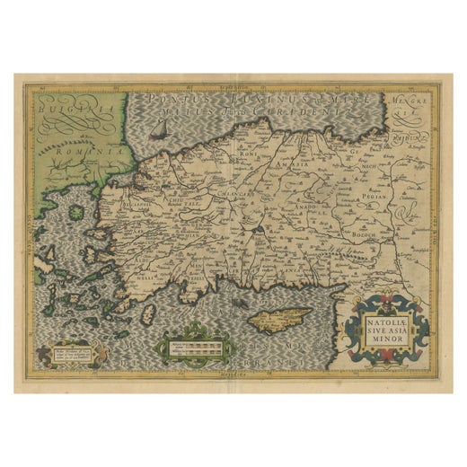
A 17th century copperplate hand-colored map entitled "The Second Table of Ireland, Udrone" by Gerard Mercator and Jodocus Hondius, published in Amsterdam in 1635 in 'Cosmographicall Description of the Fabricke & Figure of the World with new Mappes and Tables; By the studious industry of Jodocus Hondy', the first English edition of their 'Atlas Minor'. It is focused on a region of Ireland depicting present day County Carlow in Leinster Province and the city of Catherlaugh, which is now the city of Carlow. This region has an interesting history which led to Mercator producing a map focused on it. When Queen Elizabeth I forced Earl of Desmond, Gerald Fitzgerald, to renounce all his rights to family lands in Munster, Peter Carew claimed much of these land holdings in Ireland. Carew made his case to the English at Dublin Castle and was awarded title to the Barony of Udrone. He subsequently claimed title to one half the Kingdom of Cork, as well as other Irish lands.
The map is embellished with a strap work cartouche containing the name of the region. The map is beautifully hand colored with wide margins. It is presented in an archival cream colored mat measuring 14' wide x 12" high and the map sheet measures 11.25" wide x 7" high. There is English text on the verso. The map is in excellent condition.
Gerard Mercator (1512-1594) is one of the most famous cartographers of all time. He was born in Flanders and moved to Duisburg from Leuven in the Netherlands, where he lived and worked for the rest of his life. In addition to producing important maps and globes, he invented a projection on maps that presented all parallels and meridians at right angles to each other, with the distance between the parallels extending towards the poles, allowing accurate latitude and longitude calculation and navigational routes to be drawn using straight lines. This was an important technological advance for navigation at sea, as this allowed seafarers to plot their course without having to adjust their course based on frequent compass readings. This has become known as Mercator projection on maps produced by subsequent cartographers to this day. He is also the first to use the term “atlas”, which was first used to describe his collection of maps gathered in one volume. The Mercator atlas was published in 1595, a year after Mercator’s death by his heirs.
Jodocus Hondius (1563-1612) was a prominent globe maker and map engraver from Ghent (Flanders). After spending some time in London, he established his business in Amsterdam in 1593. Hondius bought the plates of Gerard Mercator in 1604 and added around 40 of his own maps in an atlas that he first published in 1606, preserving Mercator's name. After his death in 1612 in Amsterdam, the business was continued by his sons Jodocus II and Henricus, who published the English edition of the Mercator and Hondius Atlas Minor in 1635 that contained this map.
- Creator:Gerard Mercator (Artist)
- Dimensions:Height: 12 in (30.48 cm)Width: 14 in (35.56 cm)Depth: 0.13 in (3.31 mm)
- Materials and Techniques:Paper,Engraved
- Place of Origin:
- Period:Mid-17th Century
- Date of Manufacture:1635
- Condition:Wear consistent with age and use.
- Seller Location:Alamo, CA
- Reference Number:Seller: # 13151stDibs: LU5206221488442
Gerard Mercator
Gerard Mercator (1512-1594) was one of the most famous cartographers of the 16th century and, in fact, of all time. Mercator was known for his strict adherence to scientific methods of the day. He was responsible for advancing the technology of map making. For example his method of representing land masses in a cylindrical projection with north up and south down, first described in 1569, became the standard map projection for navigation. It is still referred to as The Mercator projection.
About the Seller
5.0
Vetted Professional Seller
Every seller passes strict standards for authenticity and reliability
1stDibs seller since 2020
15 sales on 1stDibs
- ShippingRetrieving quote...Shipping from: Alamo, CA
- Return Policy
Authenticity Guarantee
In the unlikely event there’s an issue with an item’s authenticity, contact us within 1 year for a full refund. DetailsMoney-Back Guarantee
If your item is not as described, is damaged in transit, or does not arrive, contact us within 7 days for a full refund. Details24-Hour Cancellation
You have a 24-hour grace period in which to reconsider your purchase, with no questions asked.Vetted Professional Sellers
Our world-class sellers must adhere to strict standards for service and quality, maintaining the integrity of our listings.Price-Match Guarantee
If you find that a seller listed the same item for a lower price elsewhere, we’ll match it.Trusted Global Delivery
Our best-in-class carrier network provides specialized shipping options worldwide, including custom delivery.More From This Seller
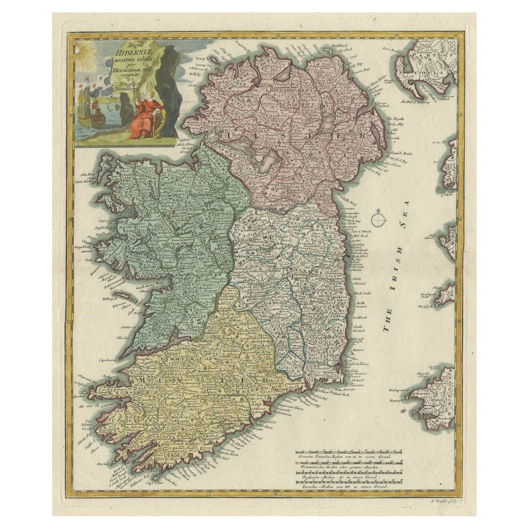
View All17th Century Hand-Colored Map of Southeastern England by Mercator and Hondius
By Gerard Mercator
Located in Alamo, CA
A 17th century copperplate hand-colored map entitled "The Sixt Table of England" by Gerard Mercator and Jodocus Hondius, published in Amsterdam in 1635 in 'Cosmographicall Descriptio...
Category
Antique Mid-17th Century Dutch Maps
Materials
Paper

England, Scotland & Ireland: A Hand Colored Map of Great Britain by Tirion
By Isaak Tirion
Located in Alamo, CA
This is a hand-colored double page copperplate map of Great Britain entitled "Nieuwe Kaart van de Eilanden van Groot Brittannien Behelzende de Kon...
Category
Antique Mid-18th Century Dutch Maps
Materials
Paper

Large 17th Century Hand Colored Map of England and the British Isles by de Wit
By Frederick de Wit
Located in Alamo, CA
A large hand colored 17th century map of England and the British Isles by Frederick de Wit entitled "Accuratissima Angliæ Regni et Walliæ Principatus", published in Amsterdam in 1680. It is a highly detailed map of England, Scotland, the Scottish Isles...
Category
Antique Late 17th Century Dutch Maps
Materials
Paper

Northern Scotland: A 16th Century Hand-colored Map by Mercator
By Gerard Mercator
Located in Alamo, CA
A framed hand-colored 16th century map of Northern Scotland by Gerard Mercator entitled "Scotiae pars Septentrionalis", published in Amsterdam in 1636. It is a highly detailed map of the northern part of Scotland, with the northwest Highlands and the cities Inverness and Aberdeen, as well as the Orkney Islands and the Hebrides. There is a decorative title cartouche in the upper left corner.
The map is presented in an antiqued brown wood...
Category
Antique 16th Century Dutch Maps
Materials
Paper

Northern Scotland: A 17th Century Hand-colored Map by Mercator
By Gerard Mercator
Located in Alamo, CA
This is a framed hand-colored 17th century map of Northern Scotland by Gerard Mercator entitled "Scotiae pars Septentrionalis", published in Amsterdam in 1636. It is a highly detailed map of the northern part of Scotland, with the northwest Highlands and the cities Inverness and Aberdeen, as well as the Orkney Islands and the Hebrides. There is a decorative title cartouche in the upper left corner.
The map is presented in an antiqued brown wood...
Category
Antique 1630s Dutch Maps
Materials
Paper

17th Century Hand Colored Map of the Liege Region in Belgium by Visscher
By Nicolaes Visscher II
Located in Alamo, CA
An original 17th century map entitled "Leodiensis Episcopatus in omnes Subjacentes Provincias distincté divisusVisscher, Leodiensis Episcopatus" by Nicolaes Visscher II, published in Amsterdam in 1688. The map is centered on Liege, Belgium, includes the area between Antwerp, Turnhout, Roermond, Cologne, Trier and Dinant.
This attractive map is presented in a cream-colored mat measuring 30" wide x 27.5" high. There is a central fold, as issued. There is minimal spotting in the upper margin and a tiny spot in the right lower margin, which are under the mat. The map is otherwise in excellent condition.
The Visscher family were one of the great cartographic families of the 17th century. Begun by Claes Jansz Visscher...
Category
Antique Late 17th Century Dutch Maps
Materials
Paper

You May Also Like
Southeastern Ireland: A 17th Century Hand Colored Map by Mercator and Hondius
By Gerard Mercator
Located in Alamo, CA
A 17th century copperplate hand-colored map entitled "The Second Table of Ireland, Udrone" by Gerard Mercator and Jodocus Hondius, published in Amsterdam in 1635 in 'Cosmographicall ...
Category
1630s Landscape Prints
Materials
Engraving

Hibernia Regnum Map by Carel Allard, 1700: Hand-Colored Provinces of Ireland
Located in Langweer, NL
This is a historical map of Ireland created by Carel Allard around 1700, titled "Hibernia Regnum in Quatuor Provincias Ultoniam, Connaciam, Lageniam, et Momoniam". The map is hand-colored and engraved. It includes two large decorative cartouches. The map is part of an atlas by Carel Allard, an Amsterdam-based cartographer.
Here are the detailed points about the map:
Maker: Carel Allard - a prominent Dutch cartographer and publisher from Amsterdam.
Atlas: Source Atlas - Likely part of an atlas published by Carel Allard, but specific title of the atlas isn't mentioned.
Interesting Features
1. Decorative Cartouches: The map features two large, ornate cartouches. One in the upper left depicts a classical figure and British Royal arms...
Category
Antique Early 1700s Maps
Materials
Paper
$2,022 Sale Price
30% Off
Decorative Hand-Coloured Antique Map of the Four Irish Provinces, Ireland, c1718
Located in Langweer, NL
Title: Regni Hiberniae Accurata Tabula per Hermanum Moll
Decorative map of the four Irish provinces, Ireland, 1718, by Christoph Weigel (with credit to Herman Moll), engraved by Mi...
Category
Antique 1710s Maps
Materials
Paper
$818 Sale Price
20% Off
1585 Mercator Map of Ireland, Entitled "Irlandiae Regnvm, " Hand Colored Ric0006
Located in Norton, MA
1585 Mercator map of Ireland, entitled
"Irlandiae Regnvm."
Hand Colored
Description: Published in Amsterdam by Mercator/Hondius ca. 1585.
Artists and Engravers: 1585 Mercator map of Ireland, entitled "Irlandiae Regnvm." Copperplate engraving on verge type hand laid paper with watermark. Description: Published in Amsterdam by Mercator/Hondius ca. 1585.Artists and Engravers: Mercator was born in Rupelmonde in Flanders and studied in Louvain under Gemma Frisius, Dutch writer, astronomer and mathematician. The excellence of his work brought him the patronage of Charles V, but in spite of his favor with the Emperor he was caught up in the persecution of Lutheran protestants and charged with heresy, fortunately without serious consequences. No doubt the fear of further persecution influenced his move in 1552 to Duisburg, where he continued the production of maps, globes and instruments. Mercator's sons and grandsons, were all cartographers and made their contributions in various ways to his atlas. Rumold, in particular, was responsible for the complete edition in 1595. The map plates...
Category
Antique 16th Century Dutch Maps
Materials
Paper

Map of Ireland: Early 19th Century - from the 1802 Tardieu Atlas
Located in Langweer, NL
Antique Map Description
**Title:** Carte d'Irlande
**Publication Details:**
- **Atlas Title:** Nouvel Atlas Universel de Géographie Ancienne et Moderne
- **Purpose:** For the Nouve...
Category
Antique Early 1800s Maps
Materials
Paper
$423 Sale Price
20% Off
Small Antique Map of England, Wales, Scotland and Ireland with Original Coloring
Located in Langweer, NL
Antique map titled 'Les Royaumes d'Angleterre d'Escosse et d'Irlande (..)'. A lovely, small map of England, Wales, Scotland and Ireland with a portion of the coastline of France and ...
Category
Antique Early 18th Century Maps
Materials
Paper
$442 Sale Price
20% Off
More Ways To Browse
Atlas Holding Globe
North American Fiberglass Benches
North American Rosewood Dining Room Chairs
Oak Octagon End Table
Oak Parquetry Coffee Table
Octagonal Book Table
Ole Wanscher Senator France
Orange Ball Chair
Orange Barrel Chairs
Ormolu Piano
Orrefors Martti Rytkonen
Oulton Leather
Our Lady Of Sorrows
Outdoor Day Beds
Outdoor Round Teak Dining Table
Oval Footstool
Overman Sweden
Ovoid Chair