Items Similar to Antique Map of the Bildt Township 'Friesland' by Halma, 1718

Want more images or videos?
Request additional images or videos from the seller
1 of 6
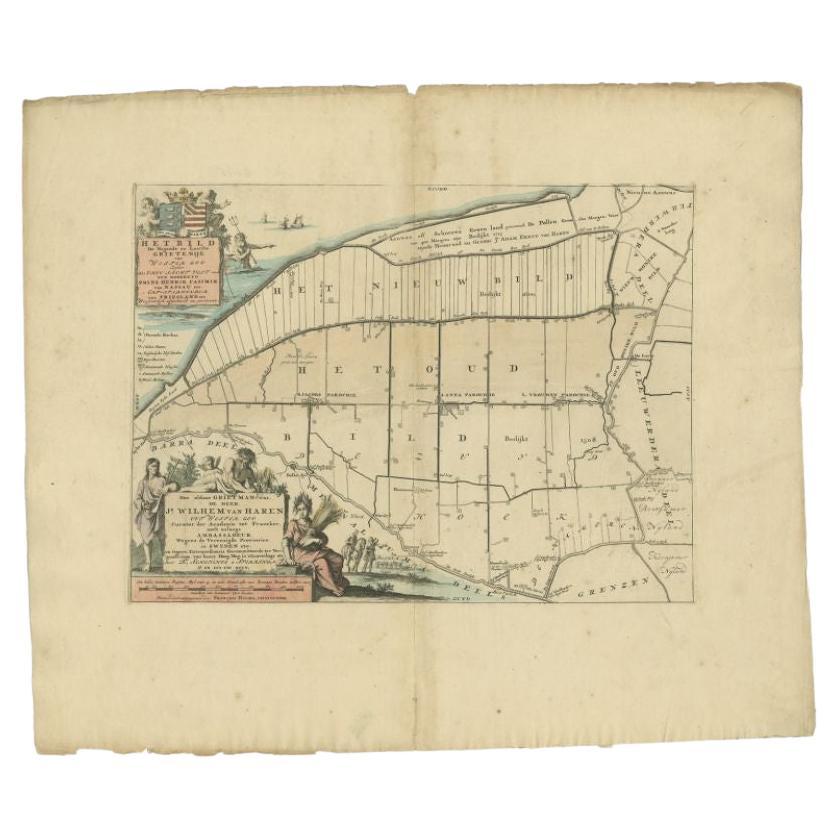
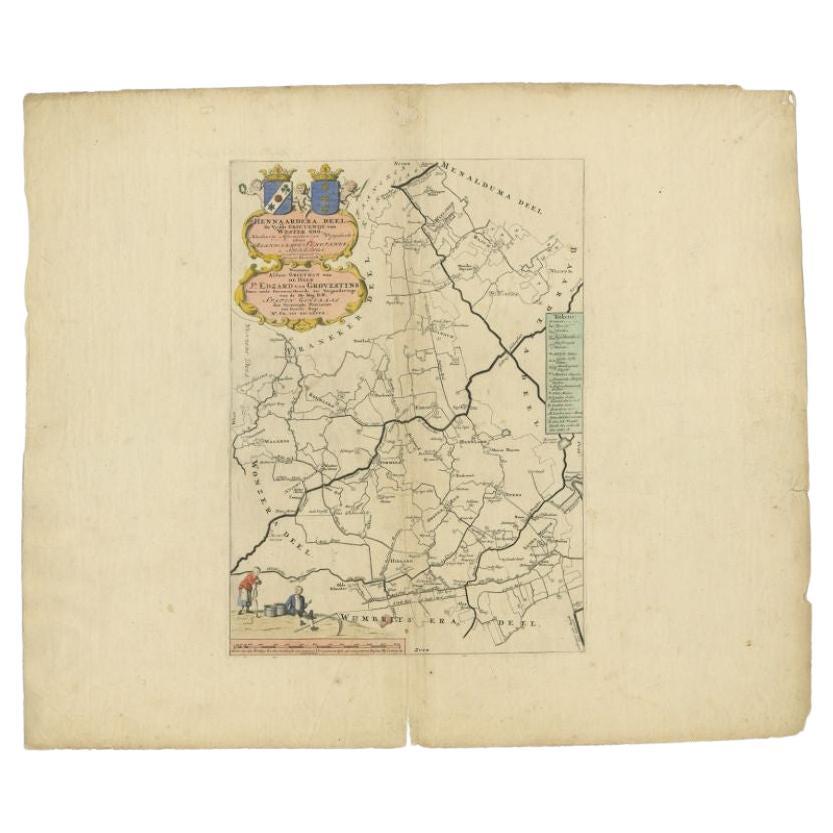
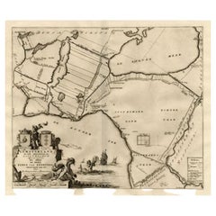
Antique Map of the Bildt Township 'Friesland' by Halma, 1718
About the Item
The map depicts the historical region of 't Bildt in Friesland, with notable places such as St. Jacobiparochie, St. Annaparochie, and Vrouwenparochie. These are still existing towns in the province of Friesland in the Netherlands. 't Bildt is known for its fertile soil and distinctive history, having been reclaimed from the sea by Dutch and Flemish settlers in the 16th century.
The coat of arms displayed is likely that of the Van Haren family, a prominent family in the history of Friesland. This map too comes from "Uitbeelding van de Heerlijkheid van Friesland" by Bernardus Schotanus à Sterringa, published by F. Halma in Leeuwarden.
St. Jacobiparochie (Sint-Jacobiparochie in Dutch), St. Annaparochie (Sint-Annaparochie), and Vrouwenparochie are still known by these names today, with St. Annaparochie being the largest village in the municipality of Waadhoeke. These towns continue to be important centers in the region, with St. Annaparochie also being the birthplace of the Van Haren family, who were historically significant to the area.
'T Bildt is the historical area depicted on the map. In modern times, the area that was historically known as 't Bildt has been merged into a larger municipality. The municipality is now known as Waadhoeke, which was formed in 2018 through the merger of several municipalities, including the former municipality of 't Bildt. Waadhoeke covers a broader area in the province of Friesland, encompassing 't Bildt and other surrounding regions. "Bildthoeke" is not a standard term used for any administrative region, but it could be a colloquial or historical reference to the corner ("hoeke" in West Frisian) of the region that includes 't Bildt.
Antique prints have long been appreciated for both their aesthetic and investment value. They were the product of engraved, etched or lithographed plates. These plates were handmade out of wood or metal, which required an incredible level of skill, patience and craftsmanship. Whether you have a house with Victorian furniture or more contemporary decor an old engraving can enhance your living space. We offer a wide range of authentic antique prints for any budget.
- Dimensions:Height: 21.66 in (55 cm)Width: 25.6 in (65 cm)Depth: 0 in (0.01 mm)
- Materials and Techniques:
- Period:
- Date of Manufacture:1718
- Condition:Condition: Good, general age-related toning. Minor wear, blank verso. Please study image carefully.
- Seller Location:Langweer, NL
- Reference Number:
About the Seller
5.0
Platinum Seller
These expertly vetted sellers are 1stDibs' most experienced sellers and are rated highest by our customers.
Established in 2009
1stDibs seller since 2017
1,938 sales on 1stDibs
Typical response time: <1 hour
- ShippingRetrieving quote...Ships From: Langweer, Netherlands
- Return PolicyA return for this item may be initiated within 14 days of delivery.
More From This SellerView All
- Antique Map of the Bildt Township 'Friesland' by Halma, 1718Located in Langweer, NLAntique map Friesland titled 'Het Bild, de negende en laatste Grietenije van Wester Goo (..)'. Old map of Friesland, the Netherlands. This map depicts the reg...Category
Antique 18th Century Maps
MaterialsPaper
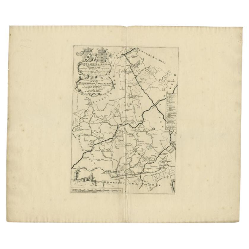
- Antique Map of the Hennaarderadeel Township 'Friesland' by Halma, 1718Located in Langweer, NLAntique map Friesland titled 'Hennaardera Deel de Vyfde Grietenije van Wester Goo (..)'. Old map of Friesland, the Netherlands. This map depicts the region of...Category
Antique 18th Century Maps
MaterialsPaper
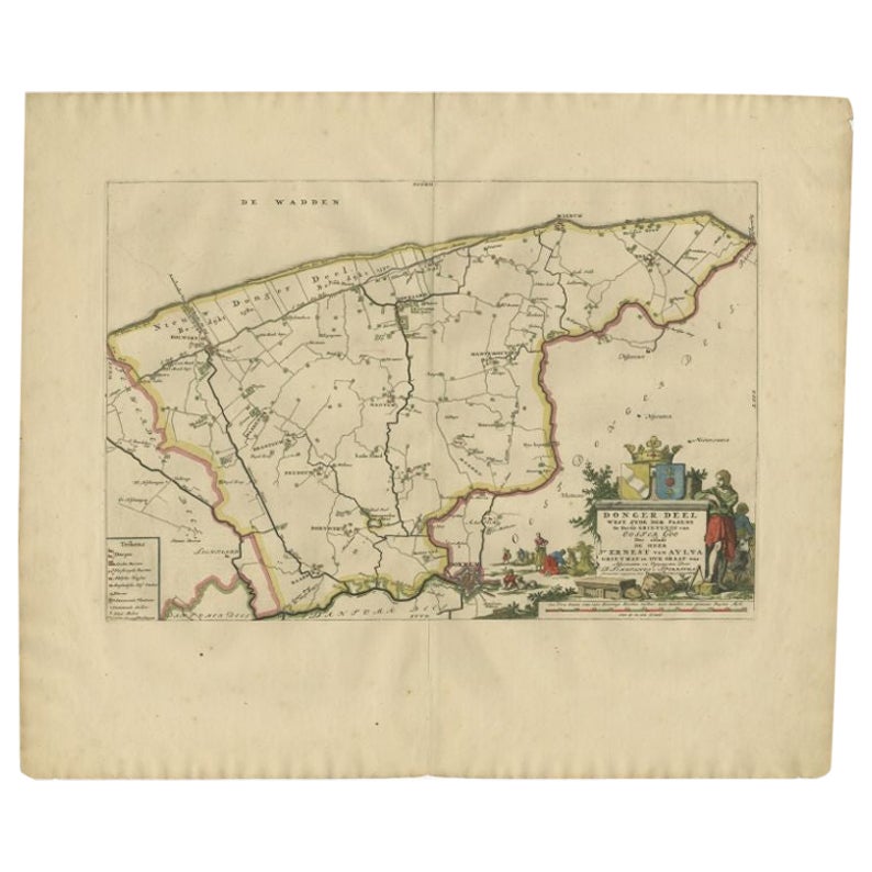
- Antique Map of the Dongeradeel Township 'Friesland' by Halma, 1718Located in Langweer, NLAntique map Friesland titled 'Donger Deel West Zyde der Pasens (..)'. Old map of Friesland, the Netherlands. This map depicts the region of Dongeradeel and includes cities and villag...Category
Antique 18th Century Maps
MaterialsPaper
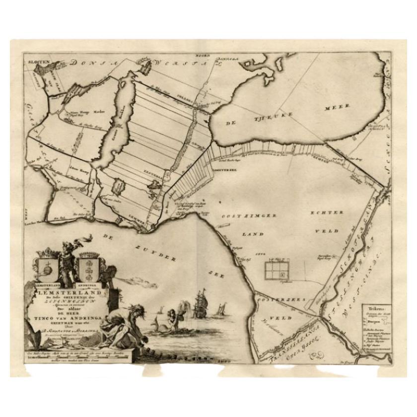
- Antique Map of the Lemsterland Township 'Friesland' by Halma, 1718Located in Langweer, NLAntique map Friesland titled 'Lemsterland de Seste Grietenije der Zevenwolden (..)'. Old map of Friesland, the Netherlands. This map depicts the region of Lemsterland and includes ci...Category
Antique 18th Century Maps
MaterialsPaper
- Antique Map of the Hennaarderadeel Township 'Friesland' by Halma, 1718Located in Langweer, NLAntique map of Friesland titled 'Hennaardera Deel de Vyfde Grietenije van Wester Goo (..)'. Old map of Friesland, the Netherlands. This map depicts the region...Category
Antique 18th Century Maps
MaterialsPaper

You May Also Like
- 1861 Topographical Map of the District of Columbia, by Boschke, Antique MapLocated in Colorado Springs, COPresented is an original map of Albert Boschke's extremely sought-after "Topographical Map of the District of Columbia Surveyed in the Years 1856 ...Category
Antique 1860s American Historical Memorabilia
MaterialsPaper
- 1907 Map of Colorado, Antique Topographical Map, by Louis NellLocated in Colorado Springs, COThis highly detailed pocket map is a topographical map of the state of Colorado by Louis Nell from 1907. The map "has been complied from all availabl...Category
Antique Early 1900s American Maps
MaterialsPaper
- Original Antique Map of The Netherlands, Engraved by Barlow, Dated 1807Located in St Annes, LancashireGreat map of Netherlands Copper-plate engraving by Barlow Published by Brightly & Kinnersly, Bungay, Suffolk. Dated 1807 Unframed.Category
Antique Early 1800s English Maps
MaterialsPaper
- Original Antique Map of the American State of Nevada, 1889Located in St Annes, LancashireGreat map of Nevada Drawn and Engraved by W. & A.K. Johnston Published By A & C Black, Edinburgh. Original colour Unframed.Category
Antique 1880s Scottish Victorian Maps
MaterialsPaper
- Original Antique Map of the American State of Oregon, 1889Located in St Annes, LancashireGreat map of Oregon Drawn and Engraved by W. & A.K. Johnston Published By A & C Black, Edinburgh. Original colour Unframed.Category
Antique 1880s Scottish Victorian Maps
MaterialsPaper
- Original Antique Map of the American State of Washington, 1889Located in St Annes, LancashireGreat map of Washington Drawn and Engraved by W. & A.K. Johnston Published By A & C Black, Edinburgh. Original colour Unframed.Category
Antique 1880s Scottish Victorian Maps
MaterialsPaper


Recently Viewed
View AllMore Ways To Browse
Coat Of Arms Engraving
Lithograph City Maps
City Map Lithograph
Antique Wood Coat Of Arms
Vans Coat Of Arms
West Coat Of Arms
Rare Compass
Map Of United Kingdom
Antique Presentation Plates
Antique Mallet
Antique 16th Century Plates
Antique Caribbean Furniture
17th Century Plate Set
Antique Bookseller
Antique Booksellers
Antique Rose Compass
Compass Rose Antique
Antique Map North America