Items Similar to Antique Map of the Danube River by Homann, c.1720


Want more images or videos?
Request additional images or videos from the seller
1 of 5
Antique Map of the Danube River by Homann, c.1720
About the Item
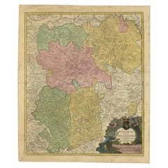
Antique map titled 'Danubii Fluminis (..)'. Regional map of the Donau river, Shows the Danube river from Belgrade in Serbia, along the border between Romania and Bulgaria up to the mouth in the Black Sea. Lower right the Bosporus with Istanbul (Constantinople).
Artists and Engravers: Homann Heirs was a German publishing firm that enjoyed a major place in the European map market throughout the eighteenth century. Founded in 1702 by Johann Baptist Homann, the business passed to his son, Christoph, upon Johann’s death in 1724. Christoph died in 1730, aged only 27, and the firm was inherited by subsequent Homann Heirs. This altered the name of the company, which was known as Homann Erben, or Homann Heirs. The firm continued in business until 1848.
Condition: Very good, general age-related toning. Please study image carefully.
Date: c.1720
Overall size: 62 x 51 cm.
Image size: 57 x 47 cm.
We sell original antique maps to collectors, historians, educators and interior decorators all over the world. Our collection includes a wide range of authentic antique maps from the 16th to the 20th centuries. Buying and collecting antique maps is a tradition that goes back hundreds of years. Antique maps have proved a richly rewarding investment over the past decade, thanks to a growing appreciation of their unique historical appeal. Today the decorative qualities of antique maps are widely recognized by interior designers who appreciate their beauty and design flexibility. Depending on the individual map, presentation, and context, a rare or antique map can be modern, traditional, abstract, figurative, serious or whimsical. We offer a wide range of authentic antique maps for any budget.
- Creator:Homann Heirs (Artist)
- Dimensions:Height: 20.08 in (51 cm)Width: 24.41 in (62 cm)Depth: 0 in (0.01 mm)
- Materials and Techniques:
- Period:
- Date of Manufacture:circa 1720
- Condition:
- Seller Location:Langweer, NL
- Reference Number:Seller: BGI-000851stDibs: LU3054327796182
About the Seller
5.0
Recognized Seller
These prestigious sellers are industry leaders and represent the highest echelon for item quality and design.
Gold Seller
Premium sellers maintaining a 4.3+ rating and 24-hour response times
Established in 2009
1stDibs seller since 2017
2,467 sales on 1stDibs
Typical response time: 1 hour
- ShippingRetrieving quote...Shipping from: Langweer, Netherlands
- Return Policy
Authenticity Guarantee
In the unlikely event there’s an issue with an item’s authenticity, contact us within 1 year for a full refund. DetailsMoney-Back Guarantee
If your item is not as described, is damaged in transit, or does not arrive, contact us within 7 days for a full refund. Details24-Hour Cancellation
You have a 24-hour grace period in which to reconsider your purchase, with no questions asked.Vetted Professional Sellers
Our world-class sellers must adhere to strict standards for service and quality, maintaining the integrity of our listings.Price-Match Guarantee
If you find that a seller listed the same item for a lower price elsewhere, we’ll match it.Trusted Global Delivery
Our best-in-class carrier network provides specialized shipping options worldwide, including custom delivery.More From This Seller
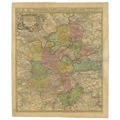
View AllAntique Map of the Danube River and Surroundings by Homann Heirs, c.1730
By Homann Heirs
Located in Langweer, NL
Antique map titled 'Danubii Fluminus (a fontibus prope Doneschingam usq Posonium urbem defignati) Pars Superior, in qua Suevia, Bavaria, Asutria, Stiria, Carinthia, Carniola, Tyrolis...
Category
Antique 18th Century Maps
Materials
Paper
$391 Sale Price
20% Off
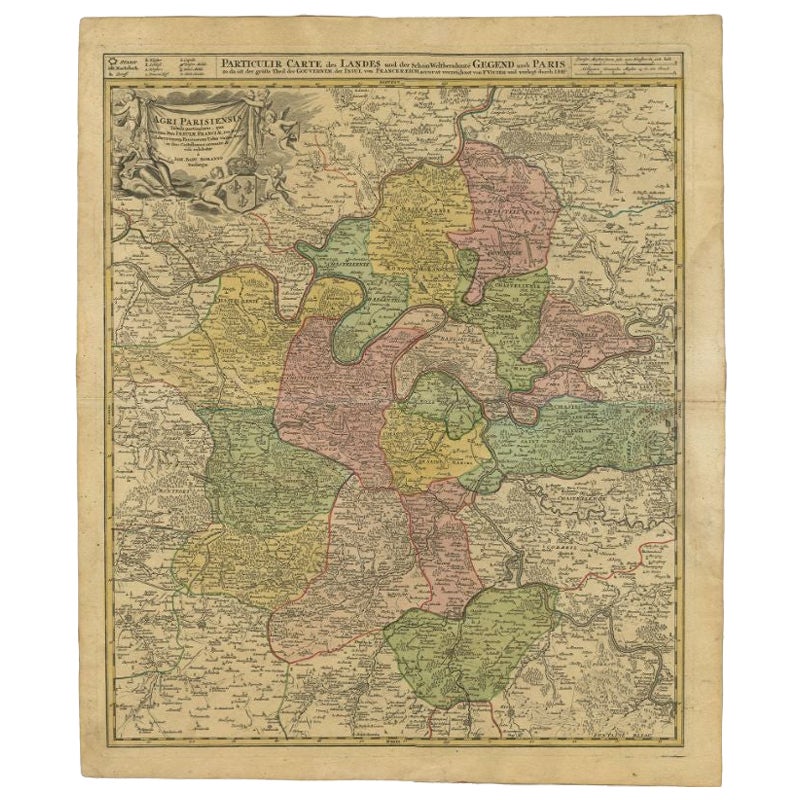
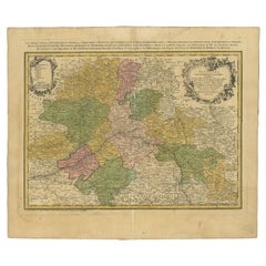
Antique Map of the Region of Paris by Homann Heirs, c.1720
By Homann Heirs
Located in Langweer, NL
Antique map titled 'Agri Parisiensis Tabula particularis, qua maxima Pars Insulae Franciae (..).' Incredibly detailed map showing everything from tiny villages to forests, farmland, ...
Category
Antique 18th Century Maps
Materials
Paper
$186 Sale Price
20% Off
Antique Map of Vlaams-Brabant by Homann Heirs, c.1720
By Homann Heirs
Located in Langweer, NL
Antique map titled 'Ducatus Brabantiae Nova Tabula in qua (..).' Fully engraved copper plate map filled with details. Covers Flanders centered roughly on Ascot and delineating the wa...
Category
Antique 18th Century Maps
Materials
Paper
$391 Sale Price
20% Off
Antique Map of the Seventeen Provinces by Homann Heirs, 1748
By Homann Heirs
Located in Langweer, NL
Antique map titled 'Belgii Universi seu Inferioris Germaniae quam XVII Provinciae (..)'. Map of the Seventeen Provinces after Tobias Meier, published by Homann's Heirs in 1748. The S...
Category
Antique 18th Century Maps
Materials
Paper

$511 Sale Price
20% Off
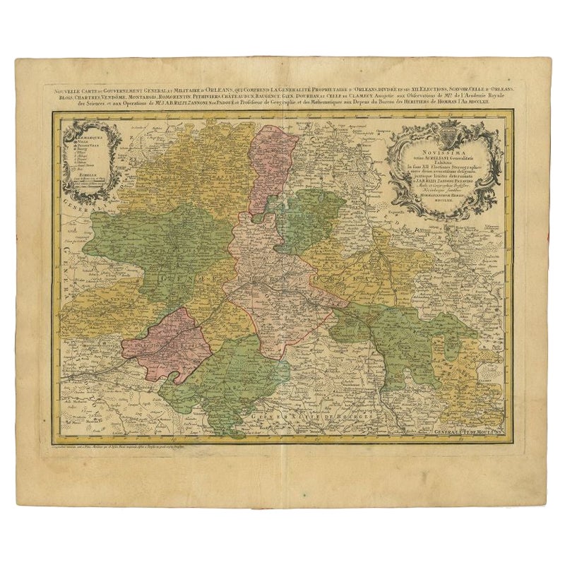
Antique Map of the Region of Orleans by Homann Heirs, c.1760
By Homann Heirs
Located in Langweer, NL
Antique map titled 'Novissima Totius Aureliani Generalitatis (..) - Nouvelle Carte du Gouvernement General et Militaire d'Orleans (..).' Detailed map by Rizzi Zononi covering the vic...
Category
Antique 18th Century Maps
Materials
Paper
$209 Sale Price
20% Off
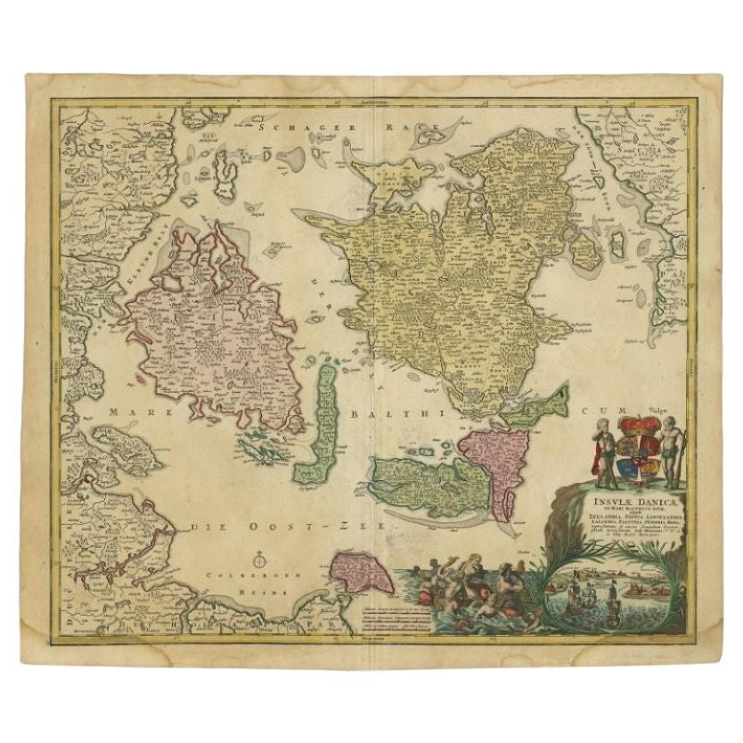
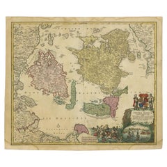
Antique Map of the Islands of Denmark by Homann Heirs, 1720
Located in Langweer, NL
Antique map titled 'Insula Danicae in Mari Balthico sitae (..).' - Map of the Danish islands situated in the Baltic Sea by J. B. Homann, (after J. Hübner's map of the region ) with g...
Category
Antique 18th Century Maps
Materials
Paper
$323 Sale Price
20% Off
You May Also Like
Hand-Colored 18th Century Homann Map of the Danube, Italy, Greece, Croatia
By Johann Baptist Homann
Located in Alamo, CA
"Fluviorum in Europa principis Danubii" is a hand colored map of the region about the Danube river created by Johann Baptist Homann (1663-1724) in his 'Atlas Novus Terrarum', publish...
Category
Antique Early 18th Century German Maps
Materials
Paper

Hand Colored 18th Century Homann Map of Austria Including Vienna and the Danube
By Johann Baptist Homann
Located in Alamo, CA
"Archiducatus Austriae inferioris" is a hand colored map of Austria created by Johann Baptist Homann (1663-1724) and published in Nuremberg, Germany in 1728 shortly after his death. ...
Category
Antique Early 18th Century German Maps
Materials
Paper

Sweden & Adjacent Portions of Scandinavia: A Hand-Colored 18th C. Map by Homann
By Johann Baptist Homann
Located in Alamo, CA
This hand-colored map of Sweden and adjacent portions of Scandinavia entitled "Regni Sueciae in Omnes suas Subjacentes Provincias accurate divisi Tabula Generalis" was created by Joh...
Category
Antique 1720s German Maps
Materials
Paper

The Kingdom of Naples and Southern Italy: A Hand-Colored 18th Century Homann Map
By Johann Baptist Homann
Located in Alamo, CA
"Novissima & exactissimus Totius Regni Neapolis Tabula Presentis Belli Satui Accommo Data" is a hand colored map of southern Italy and the ancient Kingdom of Naples created by Johann...
Category
Antique Early 18th Century German Maps
Materials
Paper

Antique Coaching Road Map, Devon, English, Regional Cartography, Georgian, 1720
Located in Hele, Devon, GB
This is an antique coaching road map of Devon. An English, framed lithograph engraving of regional interest, dating to the early 18th century and later.
Fascinating 18th century hig...
Category
Antique Early 18th Century British Georgian Maps
Materials
Wood

Hand-Colored 18th Century Homann Map of the Black Sea, Turkey and Asia Minor
By Johann Baptist Homann
Located in Alamo, CA
An attractive original early 18th century hand-colored map of the Black Sea and Turkey entitled "Carte de L'Asie Minevre ou de la Natolie et du Pont Evxin Tiree des Voyages et des Ob...
Category
Antique Early 18th Century German Maps
Materials
Paper

Recently Viewed
View AllMore Ways To Browse
Lee Reynolds Oil Painting
Leon Rosen For Pace Glass Coffee Table
Library Chair Ladder
Ligne Roset Togo Black
Limestone Table Tops
London Liberty Scarf
Louis Aubusson Sofa
Louis Xiv Iron Table
Louis Xv I Chair
Louis Xvi Chairs Black Leather
Lovo Chair
Lovo Chairs Axel Hjorth
Lucite Tulip
Lucite Tusk
Mae West Lips Sofa
Maghreb Wood Chairs
Magnussen Ponte
Mahogany 60 Inch Round Dining Room Table