Items Similar to Antique Map of Europe – Political Divisions by Andriveau-Goujon, Paris 1861


Want more images or videos?
Request additional images or videos from the seller
1 of 10
Antique Map of Europe – Political Divisions by Andriveau-Goujon, Paris 1861
$464.56
£347.88
€390
CA$647.45
A$710.10
CHF 371.37
MX$8,579.95
NOK 4,659.59
SEK 4,392.23
DKK 2,968.98
About the Item
Antique Map of Europe – Political Divisions by Andriveau-Goujon, Paris 1861
This beautifully engraved and hand-colored antique map of Europe was published in 1861 by the Parisian cartographer E. Andriveau-Goujon. Titled simply “Europe,” the map was part of the Atlas Universel and presents the political boundaries of the European continent in the mid-19th century—a period of significant change, just a decade before the unifications of Germany and Italy.
The map displays the entire European continent from the Atlantic Ocean to the Ural Mountains, including Iceland, parts of the Middle East, and North Africa. Each country is delicately colored in a pastel palette to distinguish political boundaries. The map reflects the historical configuration of Europe before the major geopolitical changes of the late 19th century. Notable historical features include the large expanse of the Russian Empire in pink, the German Confederation with its fragmented principalities, the Kingdom of Prussia, the Austrian Empire, and the still-unified Scandinavian kingdoms.
France is shaded in pink, Italy appears divided into pre-unification states, and the Ottoman Empire stretches across the Balkans and Anatolia, shaded in sandy brown. The map includes an elegant key to symbols on the left side of the sheet, indicating various capital cities, large and small towns, ports, and fortresses. Longitude is measured from the Paris meridian.
The map is bordered by a finely engraved decorative frame and printed on thick paper with wide margins, ideal for framing. It is an excellent reference piece for understanding European political geography on the eve of profound national transformations.
This piece is both a beautiful decorative artifact and a valuable document of mid-19th-century European political history—highly appealing for collectors, educators, and interior decorators.
Condition: Very good condition. Slight age-related toning and mild foxing to outer margins. Centerfold as issued. Plate number 15 in upper right. Original hand coloring preserved, clean plate impression.
Framing tips: A wide ivory or pale taupe mat with a classic black or dark wood frame will best enhance the delicate pastel tones and fine engraved lines. Ideal for a study, library, or office setting.
Technique: Engraving with original hand coloring
Maker: E. Andriveau-Goujon, Paris, 1861
- Dimensions:Height: 20.91 in (53.1 cm)Width: 27.64 in (70.2 cm)Depth: 0.01 in (0.2 mm)
- Materials and Techniques:Paper,Engraved
- Place of Origin:
- Period:
- Date of Manufacture:1861
- Condition:Condition:Good condition. Slight age-related toning and mild foxing to outer margins. Centerfold as issued. Original hand coloring preserved, clean plate impression.
- Seller Location:Langweer, NL
- Reference Number:Seller: BG-14099-41stDibs: LU3054346185252
About the Seller
5.0
Recognized Seller
These prestigious sellers are industry leaders and represent the highest echelon for item quality and design.
Platinum Seller
Premium sellers with a 4.7+ rating and 24-hour response times
Established in 2009
1stDibs seller since 2017
2,647 sales on 1stDibs
Typical response time: <1 hour
- ShippingRetrieving quote...Shipping from: Langweer, Netherlands
- Return Policy
Authenticity Guarantee
In the unlikely event there’s an issue with an item’s authenticity, contact us within 1 year for a full refund. DetailsMoney-Back Guarantee
If your item is not as described, is damaged in transit, or does not arrive, contact us within 7 days for a full refund. Details24-Hour Cancellation
You have a 24-hour grace period in which to reconsider your purchase, with no questions asked.Vetted Professional Sellers
Our world-class sellers must adhere to strict standards for service and quality, maintaining the integrity of our listings.Price-Match Guarantee
If you find that a seller listed the same item for a lower price elsewhere, we’ll match it.Trusted Global Delivery
Our best-in-class carrier network provides specialized shipping options worldwide, including custom delivery.More From This Seller
View AllAntique Europe Map with Political Boundaries – Collectible Wall Art, 1884
Located in Langweer, NL
Antique Map of Europe with Political Divisions – Black’s Atlas, 1884
This detailed engraved map of Europe was published in the New and Revised Edition of Black’s General Atlas of th...
Category
Antique 1880s Scottish Maps
Materials
Paper
Antique Map of Europe, 1903, with Intricate Political Boundaries and Rich Detail
Located in Langweer, NL
Title: Antique Map of Europe, 1903, with Intricate Political Boundaries and Rich Detail
Description:
This antique map, titled "Europe," is a finely engraved and beautifully colored ...
Category
Early 20th Century Maps
Materials
Paper

Antique Map of Europe by Levasseur, '1875'
Located in Langweer, NL
Antique map titled 'Carte générale de l'Europe'. Large map of Europe. This map originates from 'Atlas de Géographie Moderne Physique et Politique' by A. Levasseur. Published 1875.
Category
Antique Late 19th Century Maps
Materials
Paper

$357 Sale Price
40% Off
Antique Map of Europe by W. G. Blackie, 1859
Located in Langweer, NL
Antique map titled 'Europe'. Original antique map of Europe. This map originates from ‘The Imperial Atlas of Modern Geography’. Published by W. G. Blackie, 1859.
Category
Antique Mid-19th Century Maps
Materials
Paper

$238 Sale Price
20% Off
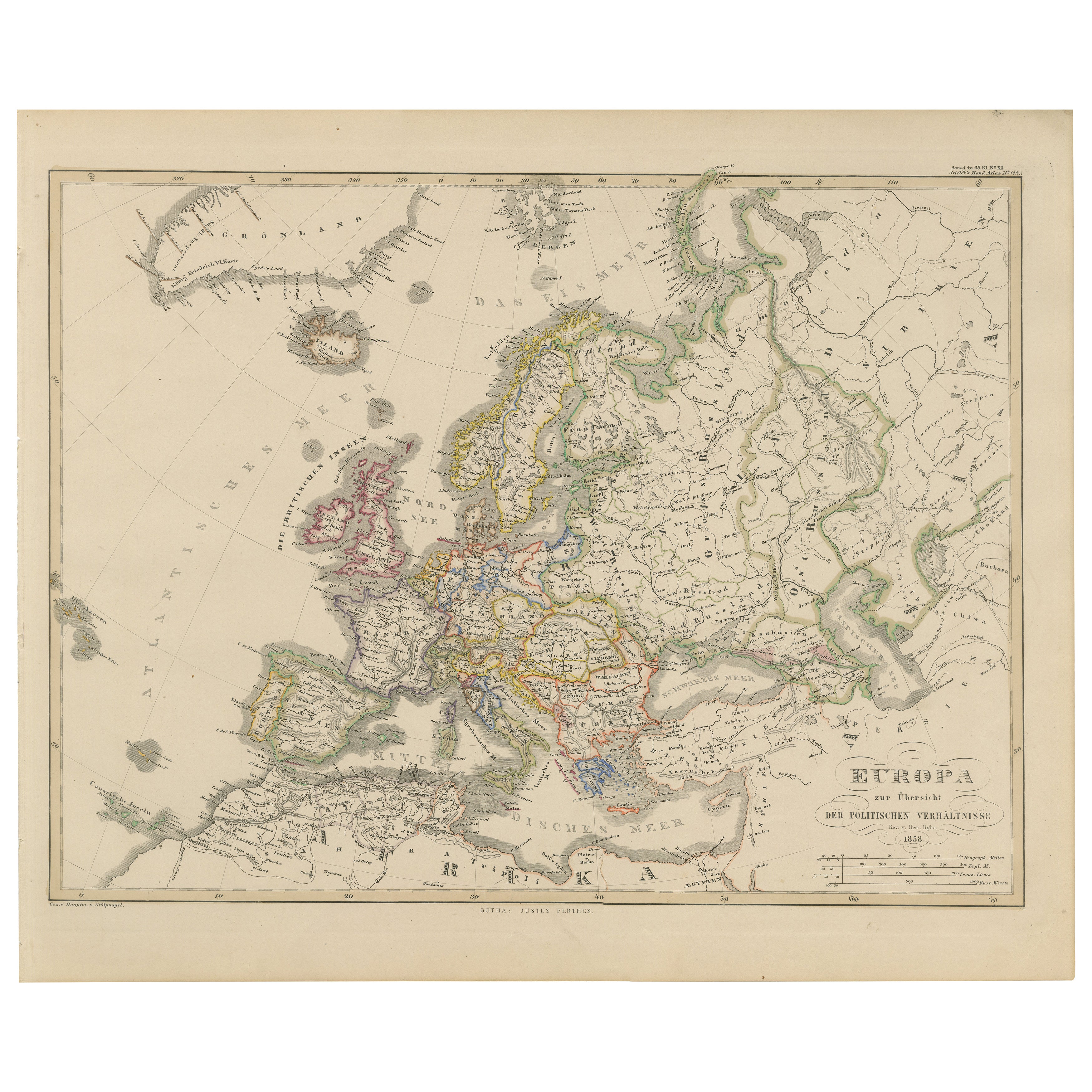
Europe Map – Political Divisions and Borders, Published in 1858
Located in Langweer, NL
Europe Map – Political Divisions and Borders 1858
This fine antique print shows Europe with its political divisions titled “Europa zur Übersicht der politischen Verhältnisse” meanin...
Category
Antique Mid-19th Century German Maps
Materials
Paper
Antique Map of the Europe Continent, 1880
Located in Langweer, NL
Antique map titled 'Europe'. Old map of the European continent. This map originates from 'Géographie Universelle Atlas-Migeon' by J. Migeon.
Artists an...
Category
Antique 19th Century Maps
Materials
Paper

$171 Sale Price
20% Off
You May Also Like
Large Original Antique Map of Europe by Sidney Hall, 1847
Located in St Annes, Lancashire
Great map of Europe
Drawn and engraved by Sidney Hall
Steel engraving
Original colour outline
Published by A & C Black. 1847
Unframed
Free shipping.
Category
Antique 1840s Scottish Maps
Materials
Paper

Map of Europe, 1844
Located in Houston, TX
Over 150 year old engraved map of Europe by Olney from 1844. Original hand color. Shows Northern Europe, Prussia and Germany.
Original antique map o...
Category
1840s More Prints
Materials
Ink, Watercolor, Handmade Paper

Original Antique Map of Europe, Arrowsmith, 1820
Located in St Annes, Lancashire
Great map of Europe
Drawn under the direction of Arrowsmith.
Copper-plate engraving.
Published by Longman, Hurst, Rees, Orme and Brown, 1820
...
Category
Antique 1820s English Maps
Materials
Paper

Russia in Europe with Poland and Finland. Century Atlas antique vintage map
Located in Melbourne, Victoria
'The Century Atlas. Russia in Europe with Poland and Finland'
Original antique map, 1903.
Central fold as issued. Map name and number printed on the reverse corners.
Sheet 40cm by ...
Category
Early 20th Century Victorian More Prints
Materials
Lithograph

Large Original Antique Map of Poland by Sidney Hall, 1847
Located in St Annes, Lancashire
Great map of Poland
Drawn and engraved by Sidney Hall
Steel engraving
Original colour outline
Published by A & C Black. 1847
Unframed
...
Category
Antique 1840s Scottish Maps
Materials
Paper

France, Northern Part. Century Atlas antique map
Located in Melbourne, Victoria
'The Century Atlas. France, Northern Part.'
Original antique map, 1903.
Inset maps of 'France in Provinces' and 'Paris and Vicinity'.
Central fold as issued. Map name and number pr...
Category
Early 20th Century Victorian More Prints
Materials
Lithograph

More Ways To Browse
Austrian Empire
Iceland Antique
Icelandic Antique
Pair Of Danish Chairs
Veneer Dining Tables
1970 Italian Armchair
Furniture Uk
House Of Denmark Table And Chairs
Louis Marble Top Side Table
Antique Russian Rugs
Baker Furniture By
For Kids
Sterling Silver Flatware Set Service For 12
Tufted Bar
Pair Of French Antique Armchairs
1970s Brass Glass Coffee Table
Antique Column Base
Charles Rennie Mackintosh For Cassina