Items Similar to Antique Map of Iowa – The Hawkeye State with Railroads & Townships, 1888
Want more images or videos?
Request additional images or videos from the seller
1 of 10
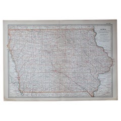
Antique Map of Iowa – The Hawkeye State with Railroads & Townships, 1888
$545.46
£405.32
€460
CA$754.95
A$840.70
CHF 438.95
MX$10,186.61
NOK 5,535.59
SEK 5,223.27
DKK 3,502.52
About the Item
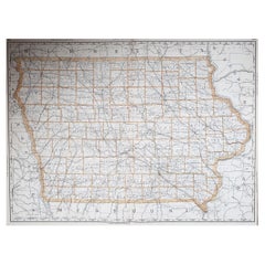
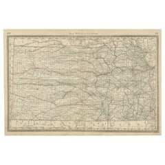
Antique Map of Iowa – Railroads, Counties & Townships, 1888
This antique engraved map of Iowa, published in 1888 by Rand, McNally & Co. in Chicago for their Improved Indexed Business Atlas and Shippers Guide, offers a detailed representation of the state during the late 19th century. It provides a township-level view of Iowa’s counties, towns, and railroads, reflecting the rapid expansion of agriculture and transportation in the heart of the American Midwest.
The map carefully outlines Iowa’s counties and subdivisions, with railroads prominently engraved in red and blue. Major lines include the Chicago, Burlington & Quincy, Chicago & North Western, Rock Island, and Milwaukee rail systems. These railroads converged on hubs such as Des Moines, Davenport, Council Bluffs, Cedar Rapids, Dubuque, and Burlington, connecting Iowa’s farms and industries to Chicago, St. Louis, and national markets. Smaller towns and depots appear throughout the state, showing the density of settlement and transport by 1888.
The township detail is especially significant, showing not only county boundaries but also local divisions, rivers, and developing towns. This level of precision would have been invaluable to shippers, landowners, and businessmen using Rand McNally’s atlas as a working tool. Iowa’s agricultural wealth—particularly corn, wheat, and livestock—depended on these transport networks, making the state one of the breadbaskets of the United States in the 19th century.
Geographic features are also represented, including the Missouri and Mississippi Rivers forming Iowa’s western and eastern borders, respectively. These waterways, together with the railroads, underline Iowa’s position as a crossroads of commerce between the Great Plains and the industrial Midwest.
Historically, this map captures Iowa during a period of extraordinary growth. By the 1880s, the state was nearly fully settled, with railroads reaching almost every county. This expansion helped Iowa become a leading agricultural state, a role it continues to hold today. The precision and clarity of this engraving showcase Rand McNally’s reputation for reliable cartography, bridging practical use with historical documentation.
Condition summary: Very good condition overall. Mild age toning and light foxing in margins. Original center fold as issued. Paper remains strong with sharp engraved detail. No major tears or repairs.
Framing tips: A walnut or oak frame pairs well with the antique qualities of this map. For a sharper presentation, a black frame with ivory matting emphasizes the intricate township details. A double mat, in ivory with a subtle green or wheat-toned accent, complements Iowa’s agricultural heritage.
Technique: Engraving
Maker: Rand, McNally & Co., Chicago, 1888
- Dimensions:Height: 14.18 in (36 cm)Width: 20.67 in (52.5 cm)Depth: 0.01 in (0.2 mm)
- Materials and Techniques:Paper,Engraved
- Place of Origin:
- Period:
- Date of Manufacture:1888
- Condition:Condition summary: Very good condition overall. Mild age toning and light foxing in margins. Original center fold as issued. Paper remains strong with sharp engraved detail. No major tears or repairs.
- Seller Location:Langweer, NL
- Reference Number:Seller: BG-12794-381stDibs: LU3054346398422
About the Seller
5.0
Recognized Seller
These prestigious sellers are industry leaders and represent the highest echelon for item quality and design.
Platinum Seller
Premium sellers with a 4.7+ rating and 24-hour response times
Established in 2009
1stDibs seller since 2017
2,589 sales on 1stDibs
Typical response time: <1 hour
- ShippingRetrieving quote...Shipping from: Langweer, Netherlands
- Return Policy
Authenticity Guarantee
In the unlikely event there’s an issue with an item’s authenticity, contact us within 1 year for a full refund. DetailsMoney-Back Guarantee
If your item is not as described, is damaged in transit, or does not arrive, contact us within 7 days for a full refund. Details24-Hour Cancellation
You have a 24-hour grace period in which to reconsider your purchase, with no questions asked.Vetted Professional Sellers
Our world-class sellers must adhere to strict standards for service and quality, maintaining the integrity of our listings.Price-Match Guarantee
If you find that a seller listed the same item for a lower price elsewhere, we’ll match it.Trusted Global Delivery
Our best-in-class carrier network provides specialized shipping options worldwide, including custom delivery.More From This Seller
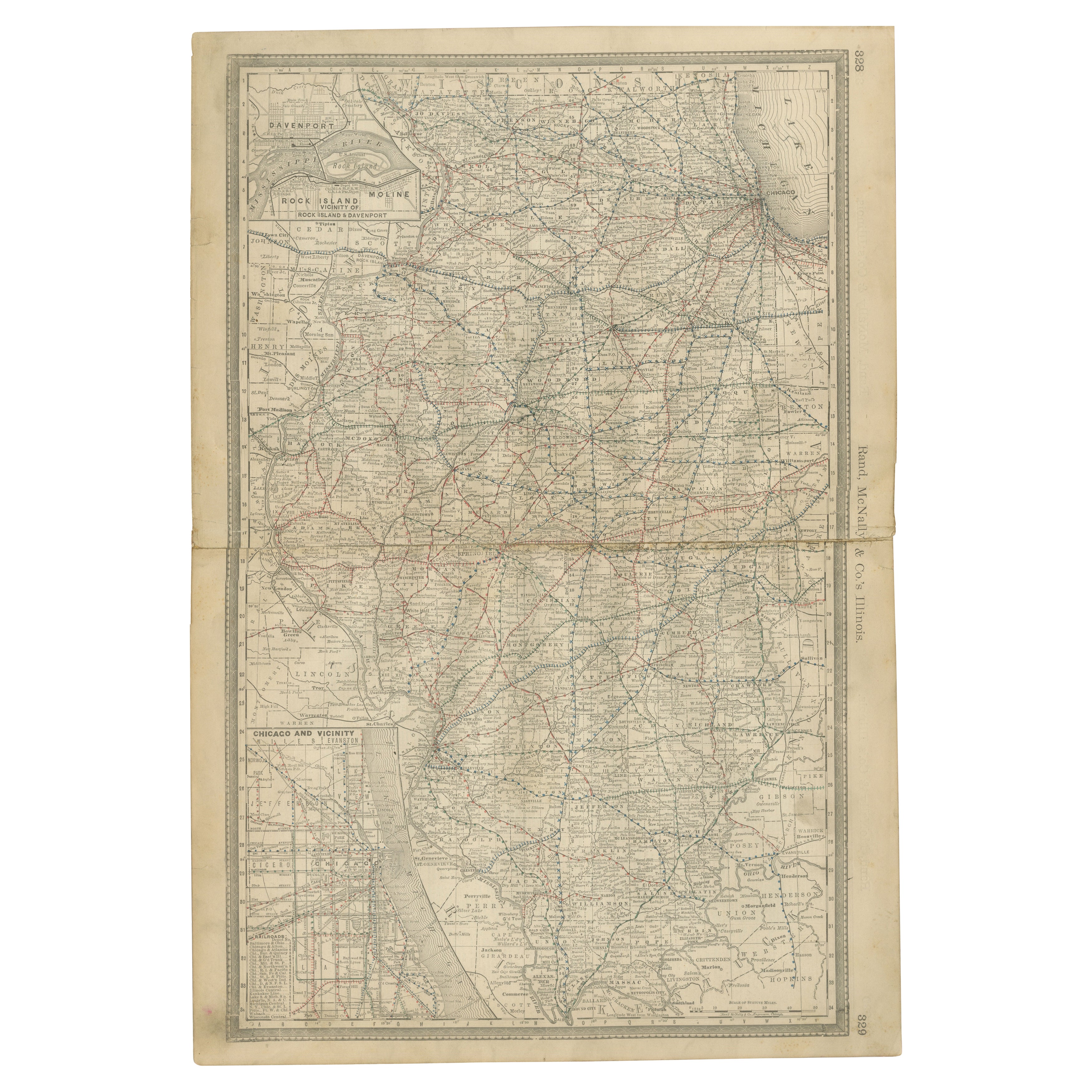
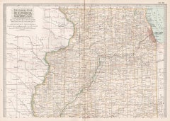
View AllDetailed Antique Map of Illinois – Railroads, Cities & Counties, 1888
Located in Langweer, NL
Antique Map of Illinois – Railroads, Cities & Counties, 1888
This finely detailed antique map shows the state of Illinois in the late 19th century, engraved and published in 1888 by...
Category
Antique Late 19th Century American Maps
Materials
Paper

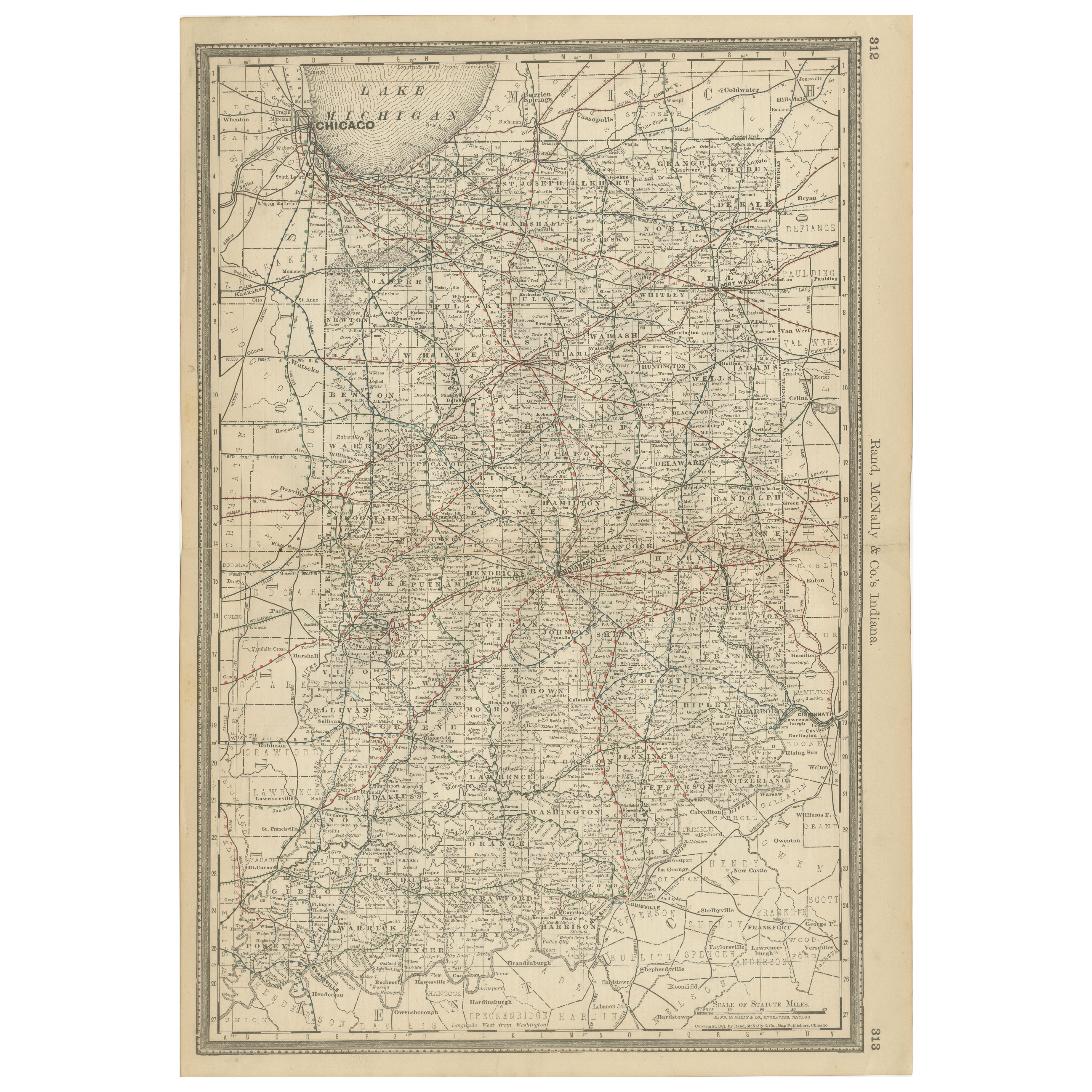
Antique Map of Indiana – The Hoosier State with Railroads & Counties, 1888
Located in Langweer, NL
Antique Map of Indiana – The Hoosier State with Railroads & Counties, 1888
This antique engraved map of Indiana, published in 1888 by Rand, McNally & Co. in Chicago for their *Impro...
Category
Antique Late 19th Century American Maps
Materials
Paper
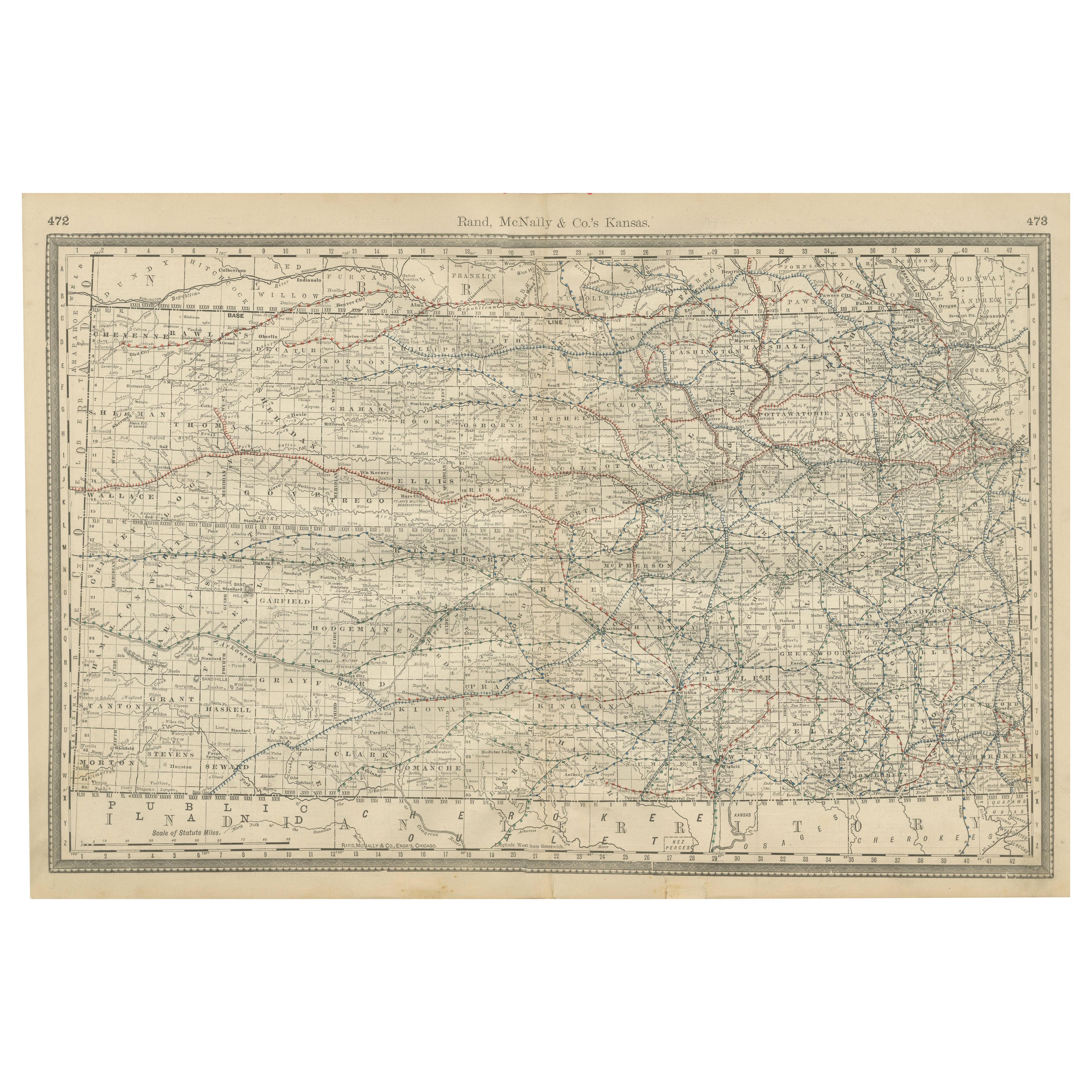
Kansas Railroad Map 1888 – Rand McNally Antique Lithograph
Located in Langweer, NL
Kansas Railroad Map 1888 – Rand McNally Antique Lithograph
This antique 1888 map of Kansas by Rand, McNally & Co. offers a detailed view of the state during a period of rapid expans...
Category
Antique Late 19th Century American Maps
Materials
Paper
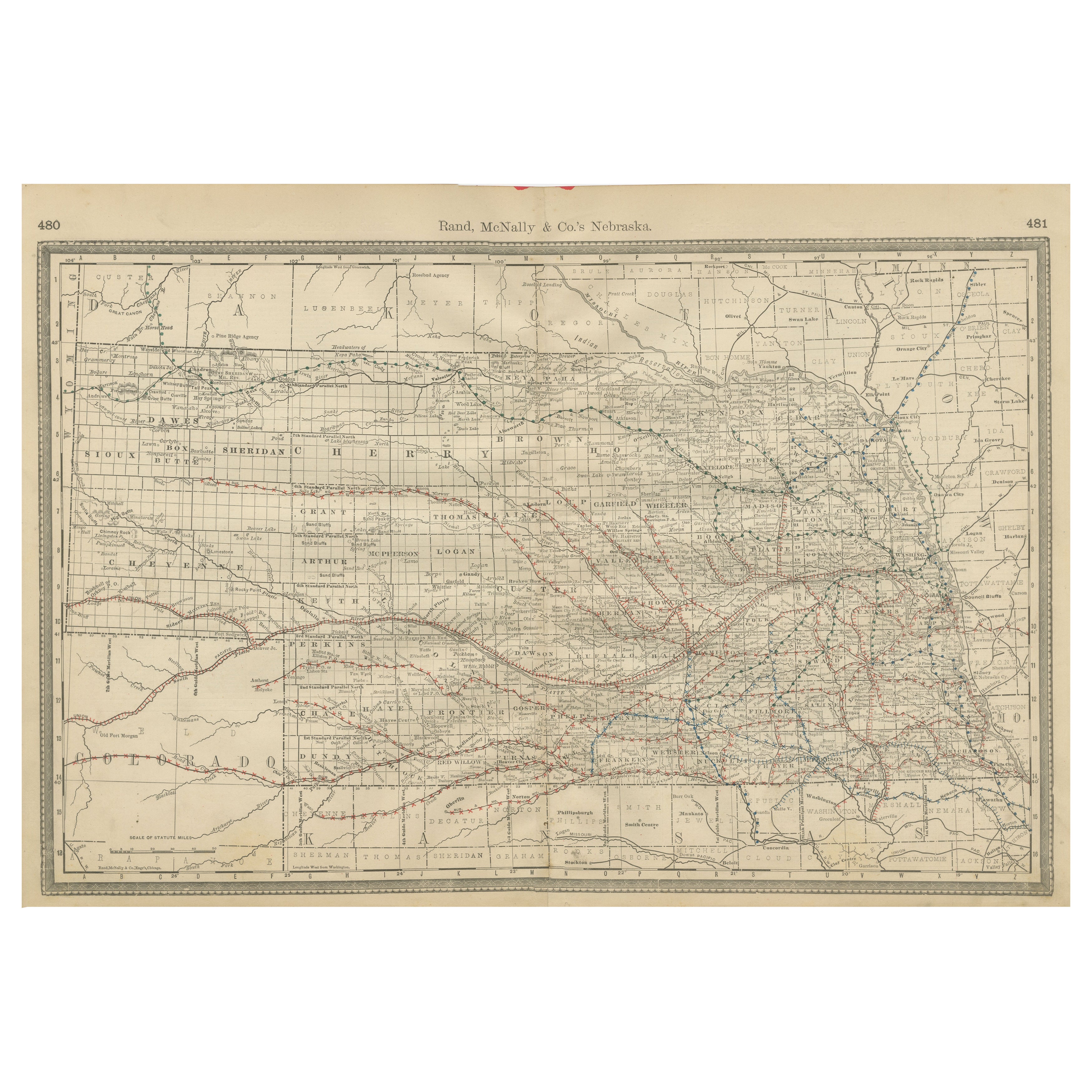
Nebraska Railroad Map 1888 – Rand McNally Antique Lithograph
Located in Langweer, NL
Nebraska Railroad Map 1888 – Rand McNally Antique Lithograph
This finely detailed map of Nebraska, published by Rand, McNally & Co. in 1888, provides an excellent overview of the st...
Category
Antique Late 19th Century American Maps
Materials
Paper
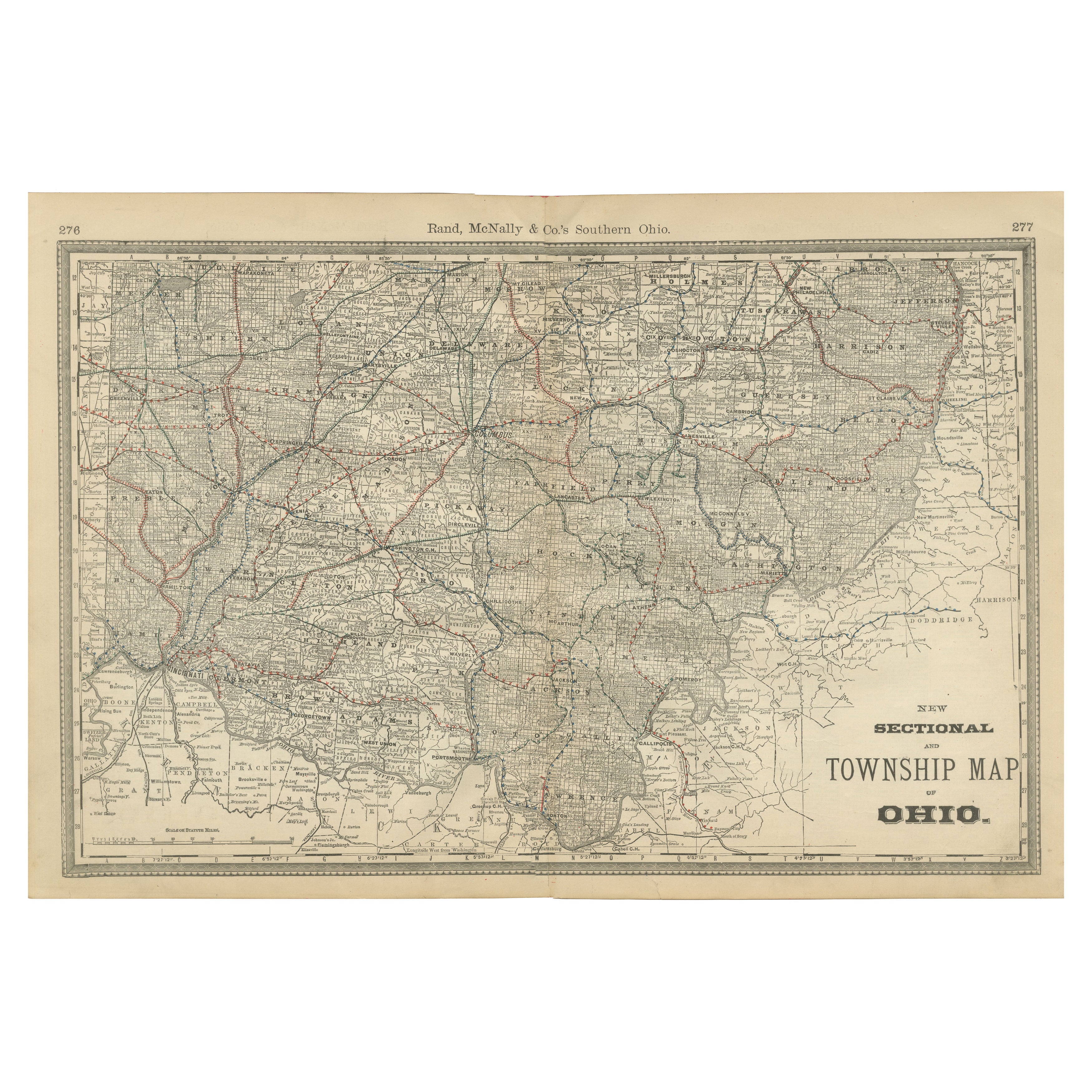
Antique Map of Southern Ohio – The Buckeye State - Railroads & Townships, 1888
Located in Langweer, NL
Antique Map of Southern Ohio – The Buckeye State with Railroads & Townships, 1888
This antique engraved map of Southern Ohio, published in 1888 by Rand, McNally & Co. in Chicago for...
Category
Antique Late 19th Century American Maps
Materials
Paper
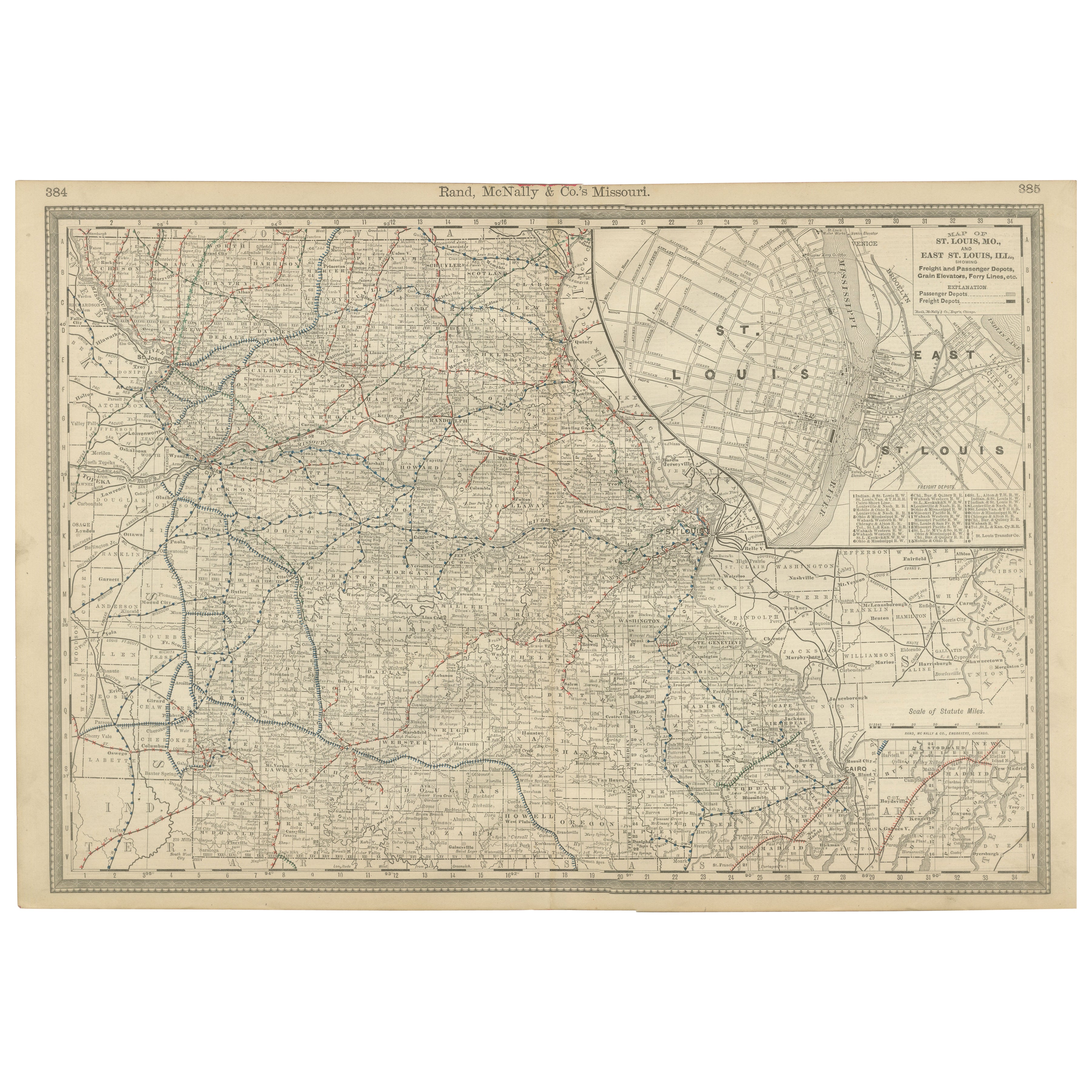
Antique Map of Missouri – The Show-Me State with St. Louis Inset, 1888
Located in Langweer, NL
Antique Map of Missouri – The Show-Me State with St. Louis Inset, 1888
This antique engraved map of Missouri, published in 1888 by Rand, McNally & Co. in Chicago for their Improved ...
Category
Antique Late 19th Century American Maps
Materials
Paper
You May Also Like
Illinois, Northern Part. USA. Century Atlas state antique vintage map
Located in Melbourne, Victoria
'The Century Atlas. Illinois, Northern Part'
Original antique map, 1903.
Central fold as issued. Map name and number printed on the reverse corners.
Sheet 29.5cm by 40cm.
Category
Early 20th Century Victorian More Prints
Materials
Lithograph
Original Antique Map of the American State of Missouri ( Northern part ), 1903
Located in St Annes, Lancashire
Antique map of Missouri ( Northern Part )
Published By A & C Black. 1903
Original colour
Good condition
Unframed.
Free shipping
Category
Antique Early 1900s English Maps
Materials
Paper

Original Antique Map of the American State of Illinois ( Southern Part ), 1903
Located in St Annes, Lancashire
Antique map of Illinois ( Southern part )
Published By A & C Black. 1903
Original colour
Good condition
Unframed.
Free shipping
Category
Antique Early 1900s English Maps
Materials
Paper

Original Antique Map of the American State of Nebraska, 1903
Located in St Annes, Lancashire
Antique map of Nebraska
Published By A & C Black. 1903
Original colour
Good condition
Unframed.
Free shipping
Category
Antique Early 1900s English Maps
Materials
Paper

Original Antique Map of the American State of Iowa, 1903
Located in St Annes, Lancashire
Antique map of Iowa
Published By A & C Black. 1903
Original colour
Good condition
Unframed.
Free shipping
Category
Antique Early 1900s English Maps
Materials
Paper
Large Original Antique Map of Iowa, USA, 1894
By Rand McNally & Co.
Located in St Annes, Lancashire
Fabulous map of Iowa.
Original color.
By Rand, McNally & Co.
Published, 1894.
Unframed.
Free shipping.
Category
Antique 1890s American Maps
Materials
Paper