Items Similar to Antique Map of Kentucky & Tennessee – The Bluegrass & Volunteer States, 1888
Want more images or videos?
Request additional images or videos from the seller
1 of 10
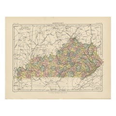
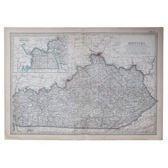
Antique Map of Kentucky & Tennessee – The Bluegrass & Volunteer States, 1888
$545.46
£405.32
€460
CA$754.95
A$840.70
CHF 438.95
MX$10,186.61
NOK 5,535.59
SEK 5,223.27
DKK 3,502.52
About the Item
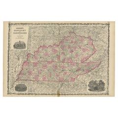
Antique Map of Kentucky & Tennessee – The Bluegrass & Volunteer States, 1888
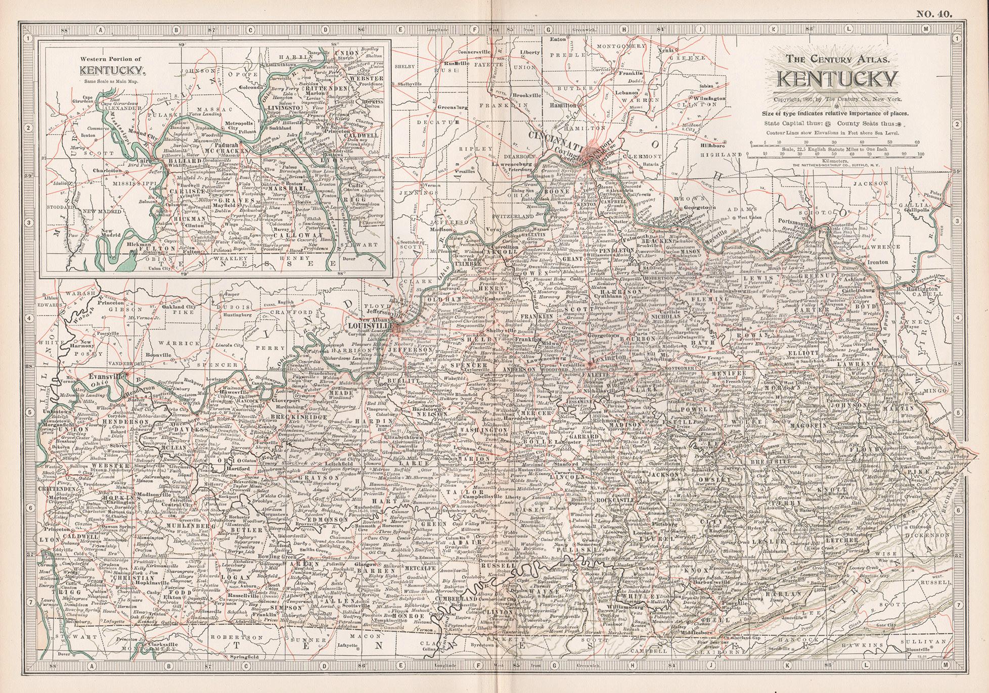
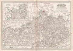
This antique engraved map of Kentucky and Tennessee, published in 1888 by Rand, McNally & Co. in Chicago for their Improved Indexed Business Atlas and Shippers Guide, provides a highly detailed view of two historically important Southern states in the late 19th century. It shows counties, towns, and an extensive network of railroads, capturing a period when rail transportation was rapidly transforming the economy and society of the post-Civil War South.
The Kentucky section, titled “New County and Railroad Map of Kentucky,” highlights the state’s counties, with Louisville, Lexington, Covington, and Frankfort (the state capital) standing out as major centers. Known as “The Bluegrass State,” Kentucky was already famous for its fertile farmland, thoroughbred horse breeding, and bourbon whiskey industry. The map shows dense railroad coverage, including the Louisville & Nashville Railroad, which connected Kentucky to major markets in the Midwest and South.
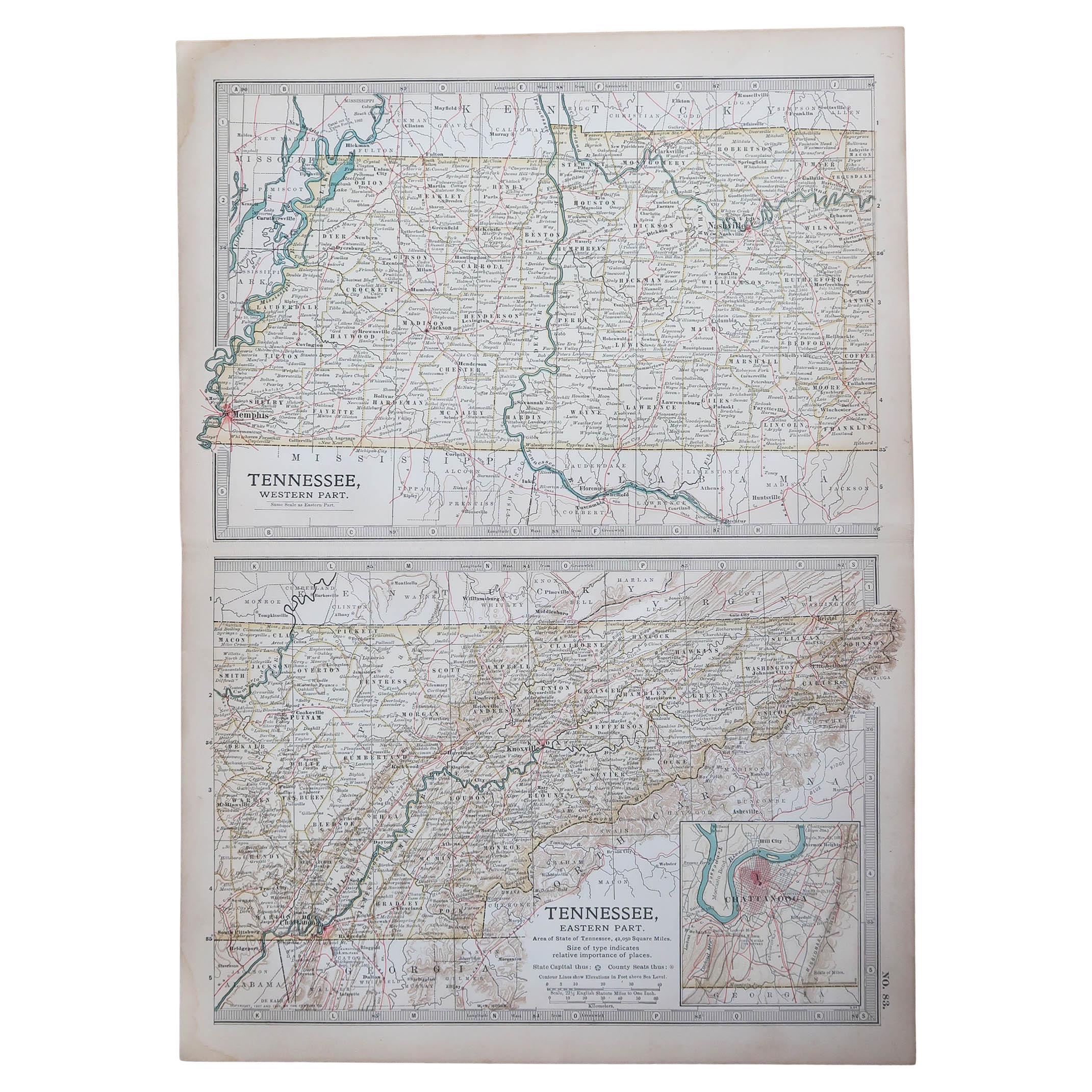
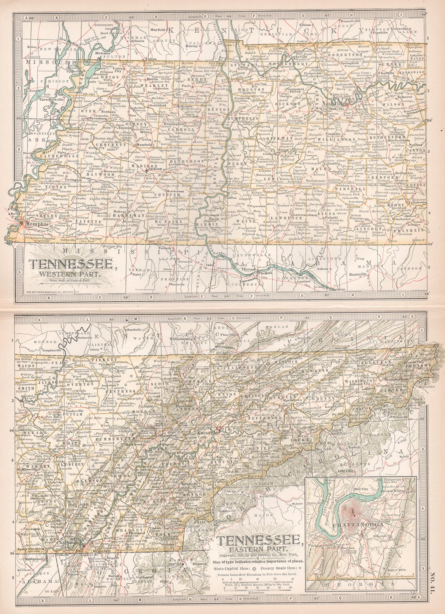
The Tennessee portion, titled “County and Railroad Map of Tennessee,” provides similar detail. Counties such as Shelby, Davidson, Knox, and Hamilton are clearly marked, along with the major cities of Memphis, Nashville (the state capital), Knoxville, and Chattanooga. Known as “The Volunteer State,” Tennessee played a critical role in American history, from its frontier heritage to its importance during the Civil War. By 1888, Tennessee’s economy was diversifying, with Memphis as a cotton trading hub, Nashville as a growing cultural and commercial center, and Chattanooga as a key industrial city connected to the railroads.
The map’s railroad detail is especially significant, with red and blue lines denoting passenger and freight routes. These include the Louisville & Nashville, the Cincinnati Southern, and the Memphis & Charleston Railroads, which linked Kentucky and Tennessee to surrounding states and national markets. The Appalachian region of eastern Tennessee is also carefully represented, with its rugged terrain and sparser settlement, contrasting with the fertile central and western regions of both states.
Historically, this map captures Kentucky and Tennessee in the Reconstruction and Gilded Age period, when both states were rebuilding and modernizing their economies. The precision of Rand McNally’s engraving, showing counties, towns, and railroads in fine detail, makes this a valuable historical artifact as well as a decorative piece.
Condition summary: Good condition overall. Mild toning of paper and light foxing at the margins. Original center fold as issued. Strong paper with crisp engraved detail. No major tears or repairs.
Framing tips: A walnut or cherry frame complements the Southern character of the map, while a black frame with ivory matting creates a striking modern presentation. A double mat, in ivory with a muted green or blue accent, highlights the dense county and railroad details.
Technique: Engraving
Maker: Rand, McNally & Co., Chicago, 1888
- Dimensions:Height: 20.67 in (52.5 cm)Width: 14.18 in (36 cm)Depth: 0.01 in (0.2 mm)
- Materials and Techniques:Paper,Engraved
- Place of Origin:
- Period:
- Date of Manufacture:1888
- Condition:Condition summary: Good condition overall. Mild toning of paper and light foxing at the margins. Original center fold as issued. Strong paper with crisp engraved detail. No major tears or repairs.
- Seller Location:Langweer, NL
- Reference Number:Seller: BG-12794-341stDibs: LU3054346402392
About the Seller
5.0
Recognized Seller
These prestigious sellers are industry leaders and represent the highest echelon for item quality and design.
Platinum Seller
Premium sellers with a 4.7+ rating and 24-hour response times
Established in 2009
1stDibs seller since 2017
2,589 sales on 1stDibs
Typical response time: <1 hour
- ShippingRetrieving quote...Shipping from: Langweer, Netherlands
- Return Policy
Authenticity Guarantee
In the unlikely event there’s an issue with an item’s authenticity, contact us within 1 year for a full refund. DetailsMoney-Back Guarantee
If your item is not as described, is damaged in transit, or does not arrive, contact us within 7 days for a full refund. Details24-Hour Cancellation
You have a 24-hour grace period in which to reconsider your purchase, with no questions asked.Vetted Professional Sellers
Our world-class sellers must adhere to strict standards for service and quality, maintaining the integrity of our listings.Price-Match Guarantee
If you find that a seller listed the same item for a lower price elsewhere, we’ll match it.Trusted Global Delivery
Our best-in-class carrier network provides specialized shipping options worldwide, including custom delivery.More From This Seller
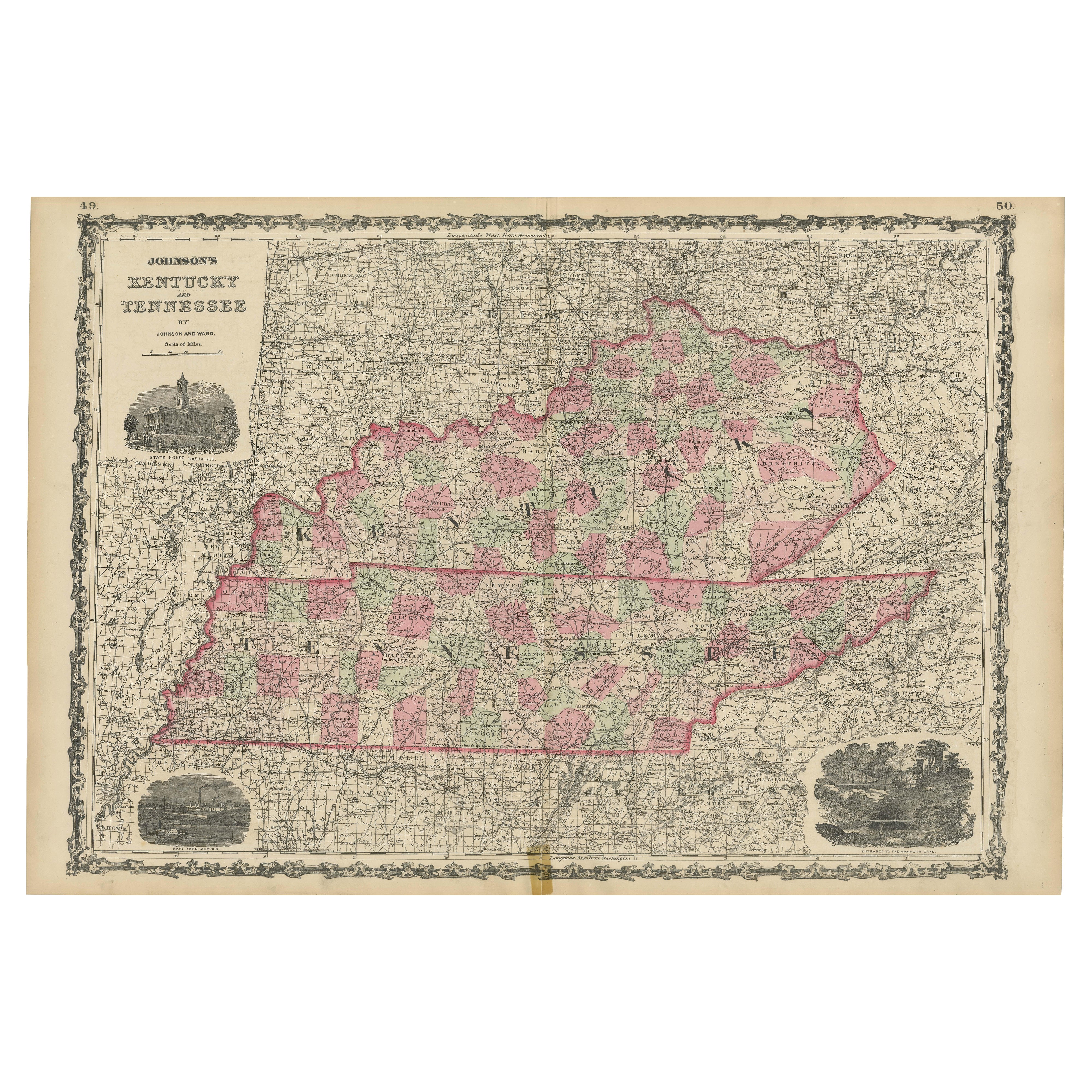
View AllCivil War Era Map of Kentucky and Tennessee with Scenic Insets, Published 1864
Located in Langweer, NL
Rare 1864 Civil War Era Map of Kentucky and Tennessee with Scenic Insets
Description: This stunning antique map, titled "Johnson's Kentucky and Tennessee," was published in 1864 by ...
Category
Antique 1860s Maps
Materials
Paper
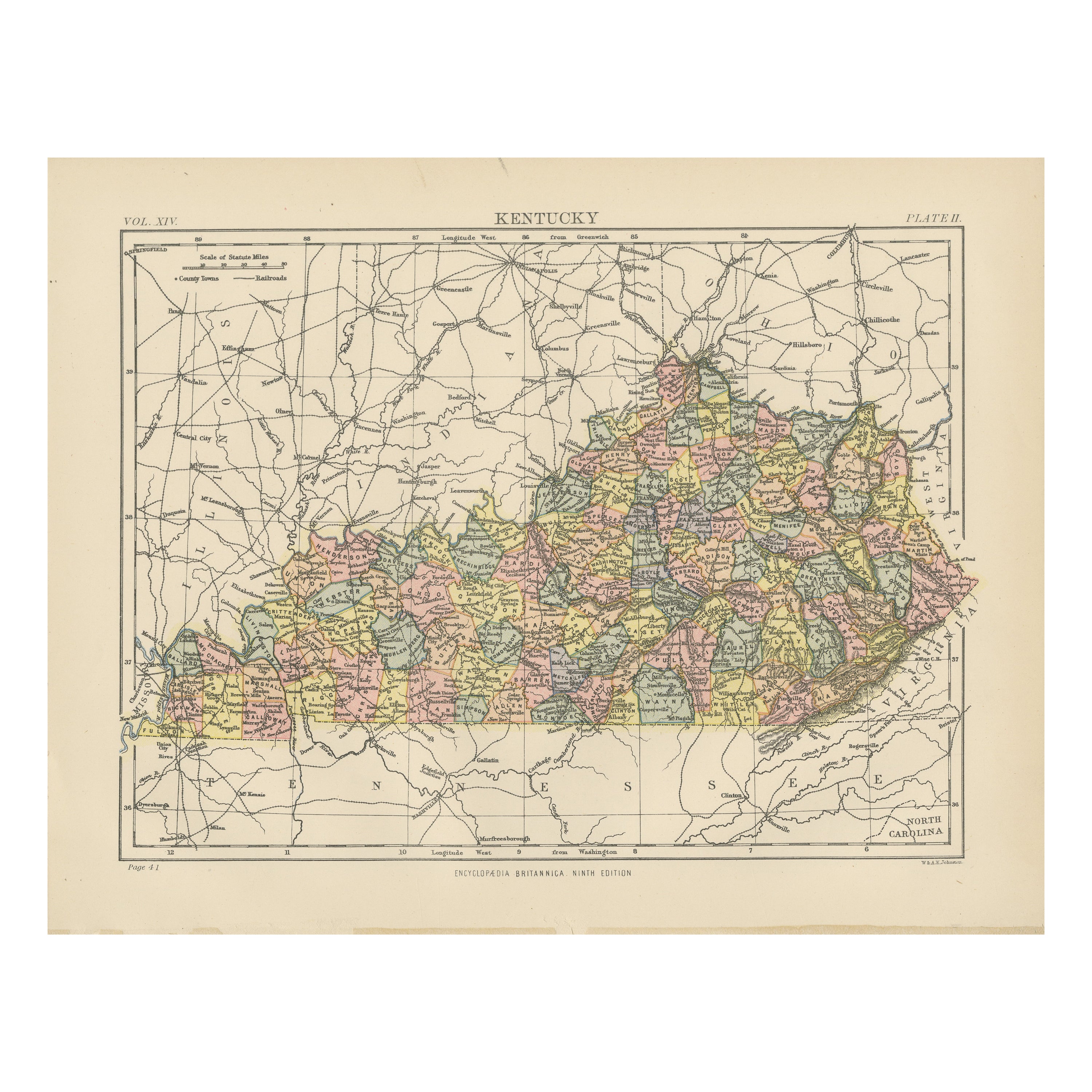
Antique Map of Kentucky
Located in Langweer, NL
Antique map titled 'Kentucky'. Original antique map of Kentucky, United States. This print originates from 'Encyclopaedia Britannica', Ninth E...
Category
Antique Late 19th Century Maps
Materials
Paper
$275 Sale Price
20% Off
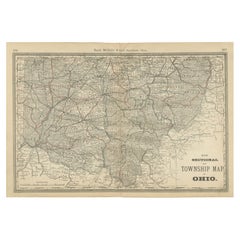
Antique Map of Southern Ohio – The Buckeye State - Railroads & Townships, 1888
Located in Langweer, NL
Antique Map of Southern Ohio – The Buckeye State with Railroads & Townships, 1888
This antique engraved map of Southern Ohio, published in 1888 by Rand, McNally & Co. in Chicago for...
Category
Antique Late 19th Century American Maps
Materials
Paper
Antique Map of Indiana – The Hoosier State with Railroads & Counties, 1888
Located in Langweer, NL
Antique Map of Indiana – The Hoosier State with Railroads & Counties, 1888
This antique engraved map of Indiana, published in 1888 by Rand, McNally & Co. in Chicago for their *Impro...
Category
Antique Late 19th Century American Maps
Materials
Paper

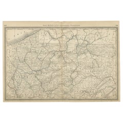
Pennsylvania Antique Map c.1888 – The Keystone State, Northwestern Counties
Located in Langweer, NL
Antique Map of Northwestern Pennsylvania – Rand McNally, circa 1888
This finely detailed antique map of northwestern Pennsylvania was published by Rand, McNally & Co. around 1888. I...
Category
Antique Late 19th Century American Maps
Materials
Paper
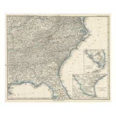
Antique Map of Tennessee, Kentucky, Virginia, Alabama, Georgia and Surroundings
Located in Langweer, NL
Antique map of part of the United States showing Alabama, Georgia, North Carolina, South Carolina, Tennessee, Kentucky, Virginia and part of Florida. With inset maps of the southern ...
Category
Antique Mid-19th Century Maps
Materials
Paper
$640 Sale Price
25% Off
Free Shipping
You May Also Like
Original Antique Map of the American State of Kentucky, 1903
Located in St Annes, Lancashire
Antique map of Kentucky
Published By A & C Black. 1903
Original colour
Good condition
Unframed.
Free shipping
Category
Antique Early 1900s English Maps
Materials
Paper
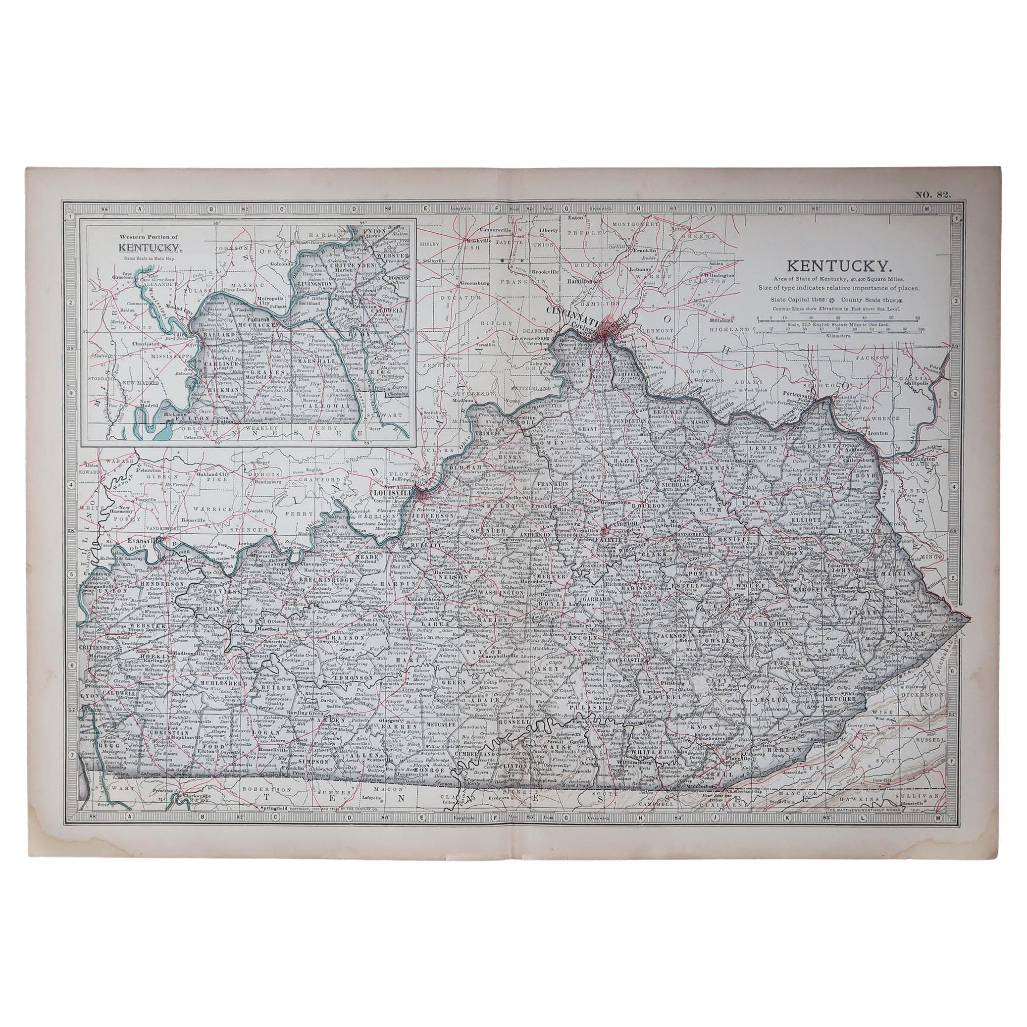
Kentucky. USA. Century Atlas state antique vintage map
Located in Melbourne, Victoria
'The Century Atlas. Kentucky'
Original antique map, 1903.
Central fold as issued. Map name and number printed on the reverse corners.
Sheet 29.5cm by 40cm.
Category
Early 20th Century Victorian More Prints
Materials
Lithograph
Original Antique Map of the American State of Tennessee, 1903
Located in St Annes, Lancashire
Antique map of Tennessee
Published By A & C Black. 1903
Original colour
Good condition
Unframed.
Free shipping
Category
Antique Early 1900s English Maps
Materials
Paper

Tennessee. USA Century Atlas state antique vintage map
Located in Melbourne, Victoria
'The Century Atlas. Tennessee'
Original antique map, 1903.
Central fold as issued. Map name and number printed on the reverse corners.
Sheet 40cm by 29.5cm.
Category
Early 20th Century Victorian More Prints
Materials
Lithograph
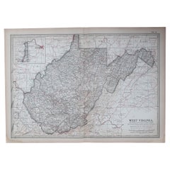
West Virginia. USA. Century Atlas state antique vintage map
Located in Melbourne, Victoria
'The Century Atlas. West Virginia'
Original antique map, 1903.
Central fold as issued. Map name and number printed on the reverse corners.
Sheet 29.5cm by 40cm.
Category
Early 20th Century Victorian More Prints
Materials
Lithograph
Original Antique Map of the American State of Virginia, 1903
Located in St Annes, Lancashire
Antique map of West Virginia
Published By A & C Black. 1903
Original colour
Good condition
Unframed.
Free shipping
Category
Antique Early 1900s English Maps
Materials
Paper