Items Similar to Antique Map of Northern Asia, with Russia, Korea and Northern Japan


Want more images or videos?
Request additional images or videos from the seller
1 of 6
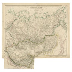
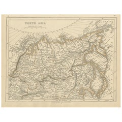
Antique Map of Northern Asia, with Russia, Korea and Northern Japan
About the Item
Antique map titled 'Nieuwe Kaart van Tartarie'. Map op Siberia and Chinese tartary. In the north Novaya Zemlya curls back to attach itself to the mainland by a narrow isthmus. In the east Kamchatka reaches down almost to Japan. Published by I. Tirion, circa 1740.
Tirion was born in Utrecht in 1705. He moved to Amsterdam in 1725 and set up shop on Damrak as a book publisher. Tirion quick rose in prominence by publishing pamphlets, historical works, and, most importantly, maps and atlases. He eventually relocated his printing house to the prestigious Kalverstraat. In his long career he produced eight atlases in multiple editions, some of which were published posthumously until about 1784. Most of his cartographic work is based on the earlier maps of Guillaume de L'Isle.
- Dimensions:Height: 16.62 in (42.2 cm)Width: 21.19 in (53.8 cm)Depth: 0.02 in (0.5 mm)
- Materials and Techniques:
- Period:
- Date of Manufacture:c.1740
- Condition:Original/contemporary hand coloring. Original folding line. General age-related toning. Minor wear and foxing. Small defect upper margin. Blank verso. Please study image carefully.
- Seller Location:Langweer, NL
- Reference Number:
About the Seller
5.0
Platinum Seller
These expertly vetted sellers are 1stDibs' most experienced sellers and are rated highest by our customers.
Established in 2009
1stDibs seller since 2017
1,928 sales on 1stDibs
Typical response time: <1 hour
- ShippingRetrieving quote...Ships From: Langweer, Netherlands
- Return PolicyA return for this item may be initiated within 14 days of delivery.
More From This SellerView All
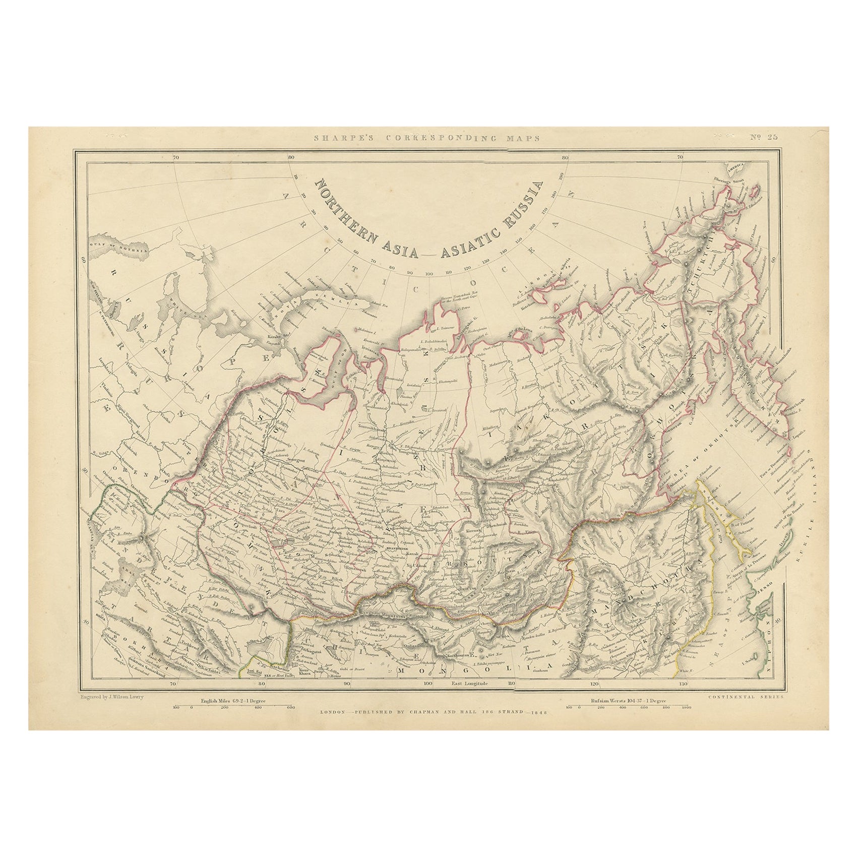
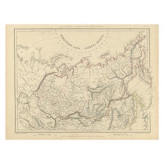
- Northern Asia, Asiatic Russia, Old Map of Russia in Asia, 1849Located in Langweer, NLAntique map titled 'Northern Asia - Asiatic Russia'. Old map of Russia in Asia. This map originates from 'Sharpe's Corresponding Atlas (..)' by J. Sharpe. Artists and Engravers: Published by Chapman and Hall.Category
Antique 1840s Maps
MaterialsPaper
- Antique Map of China, Korea, Japan and the Northern Philippines, circa 1780Located in Langweer, NLAntique map titled 'Carte de l'Empire de la Chine de la Tartarie Chinoise, et du Royaume de Corée'. Interesting and detailed map of China, Korea, Japan and the Northern Philippines. ...Category
Antique Late 18th Century Maps
MaterialsPaper
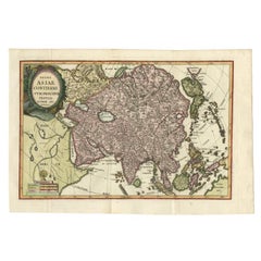
- Antique Map of Continental Asia, with Japan, Arabia, India, Russia, etc c.1702Located in Langweer, NLAntique map titled 'Totius Asiae Continens (..).' On this map of continental Asia and the adjacent islands Japan is shown with an oversized Terra Iedso (Hokkaido) connected with Honshu via a narrow isthmus. The Compagnie Land of the de Vries expedition is shown above, separated by a narrow strait named after the explorer. Nova Zembla is depicted correctly as an island, but the northeastern part of Siberia, the Chukchi peninsula and Kamchatka are missing. A portion of Australia is shown as Nova Hollandia...Category
Antique 18th Century Maps
MaterialsPaper
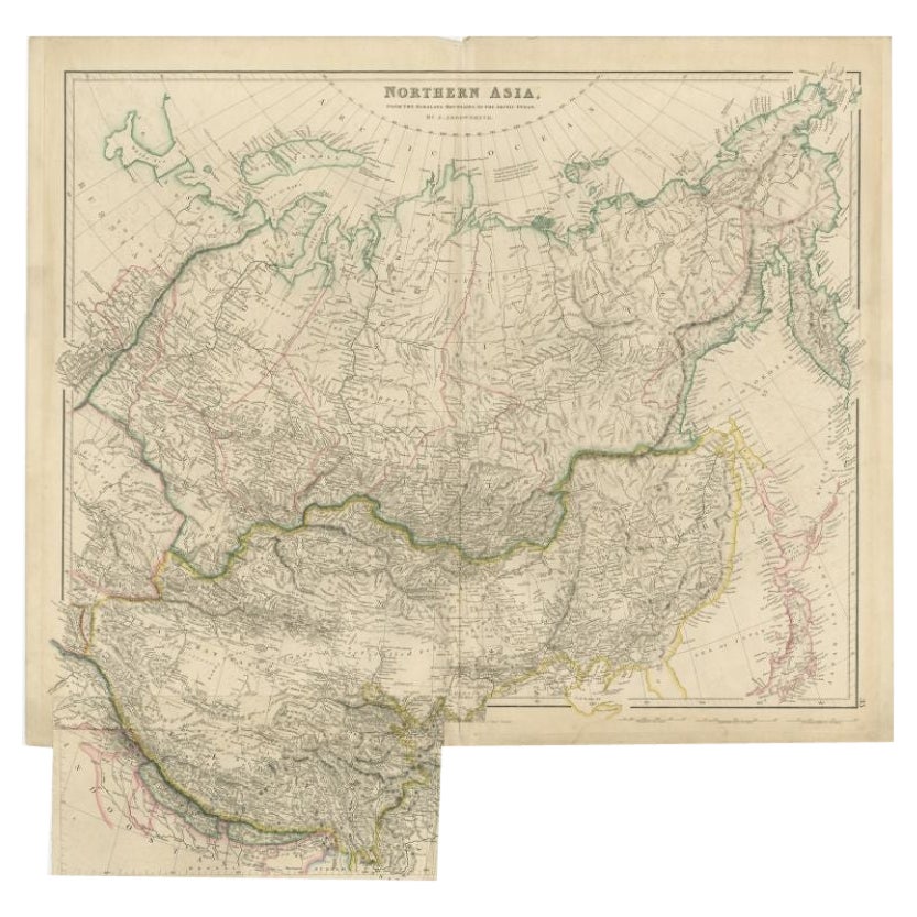
- Antique Map of Northern Asia by Arrowsmith, 1834Located in Langweer, NLAntique map titled 'Northern Asia, from the Himalaya Mountains to the Arctic Ocean'. Large and detailed map of Northern Asia, taking in Mongolia, Tibet, Bhutan, Tartary, Siberia and ...Category
Antique 19th Century Maps
MaterialsPaper
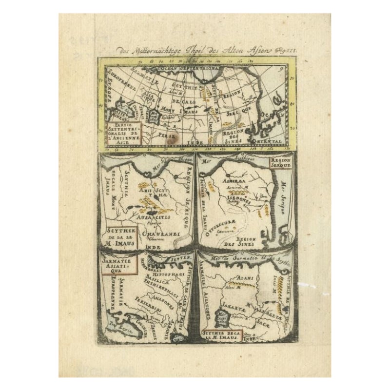
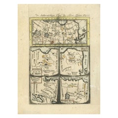
- Antique Map of Northern Asia by Mallet, 1719Located in Langweer, NLAntique map titled 'Das Mitternächtige Theil des Alten Asien'. This sheet of five miniature maps describes the northern part of Asia in classical times, perhaps circa 150 AD. At the top, an overview map shows the main regions and territories, which are pictured in more detail below. From left to right, the four maps below depict Scythia east of the Imaus (Pamir) Mountains, Serica, Sychia west of the Pamir mountains, and Sarmatia, the last of which borders the Black Sea. Originates from Alain Manesson Mallet's 'Description de l 'Univers' (German edition). Artists and Engravers: Alain Manesson Mallet (1630-1706) was a French cartographer and engineer. He started his career as a soldier in the army of Louis XIV, became a Sergeant-Major in the artillery and an Inspector of Fortifications. He also served under the King of Portugal, before returning to France, and his appointment to the court of Louis XIV. His military engineering and mathematical background led to his position teaching mathematics at court. His major publications were Description de L'Univers (1683) in 5 volumes, and Les Travaux de Mars ou l'Art de la Guerre (1684) in 3 volumes. His Description de L'Universe contains a wide variety of information, including star maps...Category
Antique 18th Century Maps
MaterialsPaper
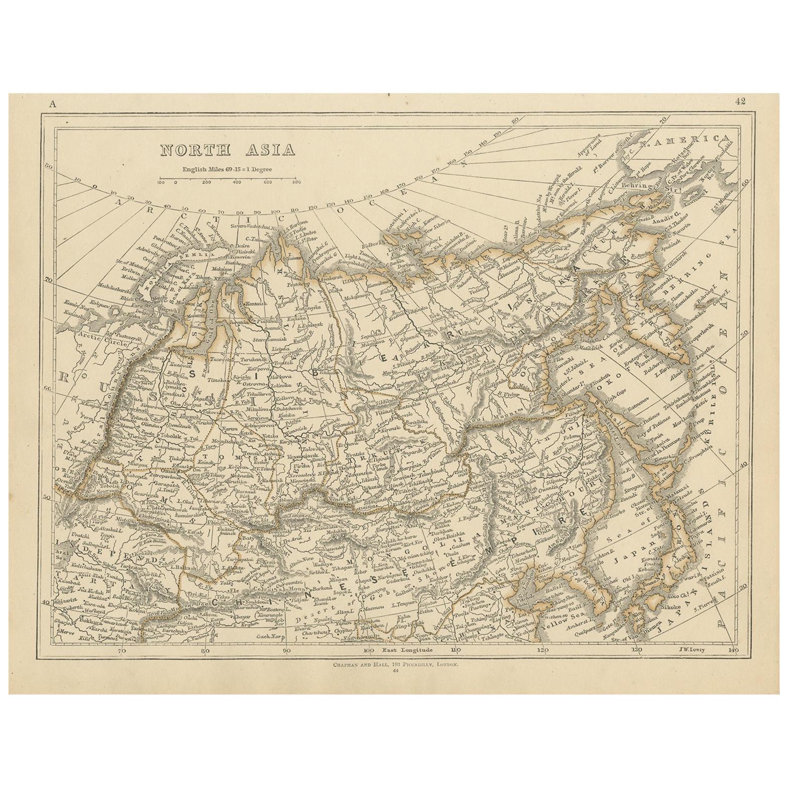
- Antique Map of Northern Asia by Lowry, 1852Located in Langweer, NLAntique map titled 'North Asia'. Original map of Northern Asia. This map originates from 'Lowry's Table Atlas constructed and engraved from the most recent authorities' by J.W. Lowry...Category
Antique Mid-19th Century Maps
MaterialsPaper

You May Also Like
- Original Antique Map of Russia By Arrowsmith. 1820Located in St Annes, LancashireGreat map of Russia Drawn under the direction of Arrowsmith Copper-plate engraving Published by Longman, Hurst, Rees, Orme and Brown, 1820 Unframed.Category
Antique 1820s English Maps
MaterialsPaper
- Original Antique Map of South East Asia, Arrowsmith, 1820Located in St Annes, LancashireGreat map of South East Asia Drawn under the direction of Arrowsmith Copper-plate engraving Published by Longman, Hurst, Rees, Orme and Brown, 1820 Unframed.Category
Antique 1820s English Maps
MaterialsPaper
- Original Antique Decorative Map of Japan, Fullarton, C.1870Located in St Annes, LancashireGreat map of Japan Wonderful figural border From the celebrated Royal Illustrated Atlas Lithograph. Original color. Published by Fullarton, Edinburgh, C.1870 Unframed...Category
Antique 1870s Scottish Maps
MaterialsPaper
- Large Original Antique Map of Asia by Sidney Hall, 1847Located in St Annes, LancashireGreat map of Asia Drawn and engraved by Sidney Hall Steel engraving Original colour outline Published by A & C Black. 1847 Unframed Free shippingCategory
Antique 1840s Scottish Maps
MaterialsPaper
- Antique French Map of Asia Including China Indoneseia India, 1783Located in Amsterdam, Noord HollandVery nice map of Asia. 1783 Dedie au Roy. Additional information: Country of Manufacturing: Europe Period: 18th century Qing (1661 - 1912) Condition: Overall Condition B (Good Used)...Category
Antique 18th Century European Maps
MaterialsPaper
- Antique 1803 Italian Map of Asia Including China Indoneseia IndiaLocated in Amsterdam, Noord HollandAntique 1803 Italian Map of Asia Including China Indoneseia India Very nice map of Asia. 1803. Additional information: Type: Map Country of Manufacturing: Europe Period: 19th centu...Category
Antique 19th Century European Maps
MaterialsPaper


Recently Viewed
View AllMore Ways To Browse
Maps Of Sea
Pakistan Antique Map
Johannes Janssonius On Sale
Bolivia Antique Map
Albania Map
Wyld Globes
Ecuador Antique Map
Stock Charts
Antique Arkansas Maps
Antique Barbie Furniture
Carte Egypte Antique
La Syrie Antique
Antique Map Of Puerto Rico
Map Of Wyoming
Antique Citroen
Staffordshire Antique Map
Staffordshire Map
Nicolas De Fer