Items Similar to Antique Map of Part of Borneo 'Kalimantan' Indonesia, by Vandermaelen, C.1825
Want more images or videos?
Request additional images or videos from the seller
1 of 7
Antique Map of Part of Borneo 'Kalimantan' Indonesia, by Vandermaelen, C.1825
About the Item
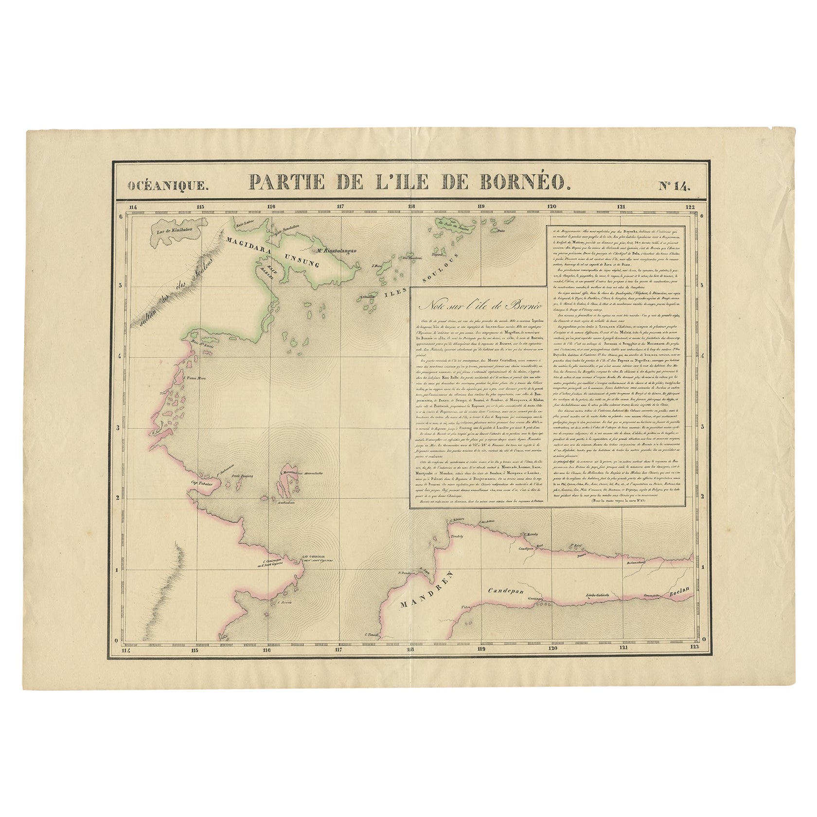
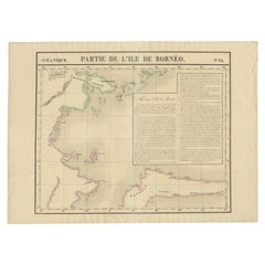
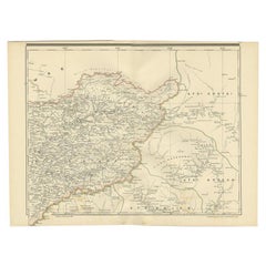
Antique map titled 'Partie de l'Ile de Bornéo'. Map of a portion of Borneo, primarily the Southern part of the Island, the Strait of Macassar and the Staffinaff Islands. Originates from 'Atlas Universel' by P.M. Vandermaelen.
Artists and Engravers: Philippe Marie Vandermaelen (1795-1869) was a Belgian cartographer and geographer known for his pioneering use of technology and his leadership in establishing the important 'Establissement geographique de Bruxelles'.
Condition: Good, age-related toning. Please study image carefully.
Date: circa 1825
Overall size: 70 x 53 cm.
Image size: 56 x 47 cm.
We sell original antique maps to collectors, historians, educators and interior decorators all over the world. Our collection includes a wide range of authentic antique maps from the 16th to the 20th centuries. Buying and collecting antique maps is a tradition that goes back hundreds of years. Antique maps have proved a richly rewarding investment over the past decade, thanks to a growing appreciation of their unique historical appeal. Today the decorative qualities of antique maps are widely recognized by interior designers who appreciate their beauty and design flexibility. Depending on the individual map, presentation, and context, a rare or antique map can be modern, traditional, abstract, figurative, serious or whimsical. We offer a wide range of authentic antique maps for any budget.
- Dimensions:Height: 20.87 in (53 cm)Width: 27.56 in (70 cm)Depth: 0 in (0.01 mm)
- Materials and Techniques:
- Period:
- Date of Manufacture:c.1825
- Condition:Condition: Good, age-related toning. Please study image carefully.
- Seller Location:Langweer, NL
- Reference Number:
About the Seller
5.0
Platinum Seller
These expertly vetted sellers are 1stDibs' most experienced sellers and are rated highest by our customers.
Established in 2009
1stDibs seller since 2017
1,933 sales on 1stDibs
Typical response time: <1 hour
- ShippingRetrieving quote...Ships From: Langweer, Netherlands
- Return PolicyA return for this item may be initiated within 14 days of delivery.
More From This SellerView All
- Antique Map of Part of Borneo 'Kalimantan' Indonesia by Vandermaelen, C.1825Located in Langweer, NLAntique map titled 'Partie de l'Ile de Bornéo'. Map of a portion of Borneo, showing Magidara Unsung, Isles Soulous, Mandren and Candepan, along with many other places in the area. Or...Category
Antique 19th Century Maps
MaterialsPaper
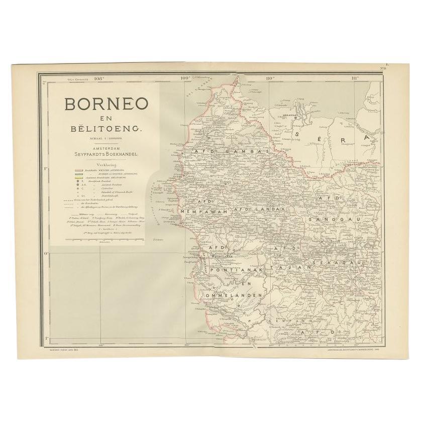
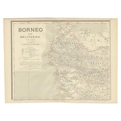
- Antique Map of West Kalimantan, Borneo, Indonesia, 1900Located in Langweer, NLAntique map titled 'Borneo en Belitoeng'. Old map of West Kalimantan, Borneo. This map originates from 'Atlas van Nederlandsch Oost- en West-Indië' by I. Dornseiffen. Artists and...Category
20th Century Maps
MaterialsPaper
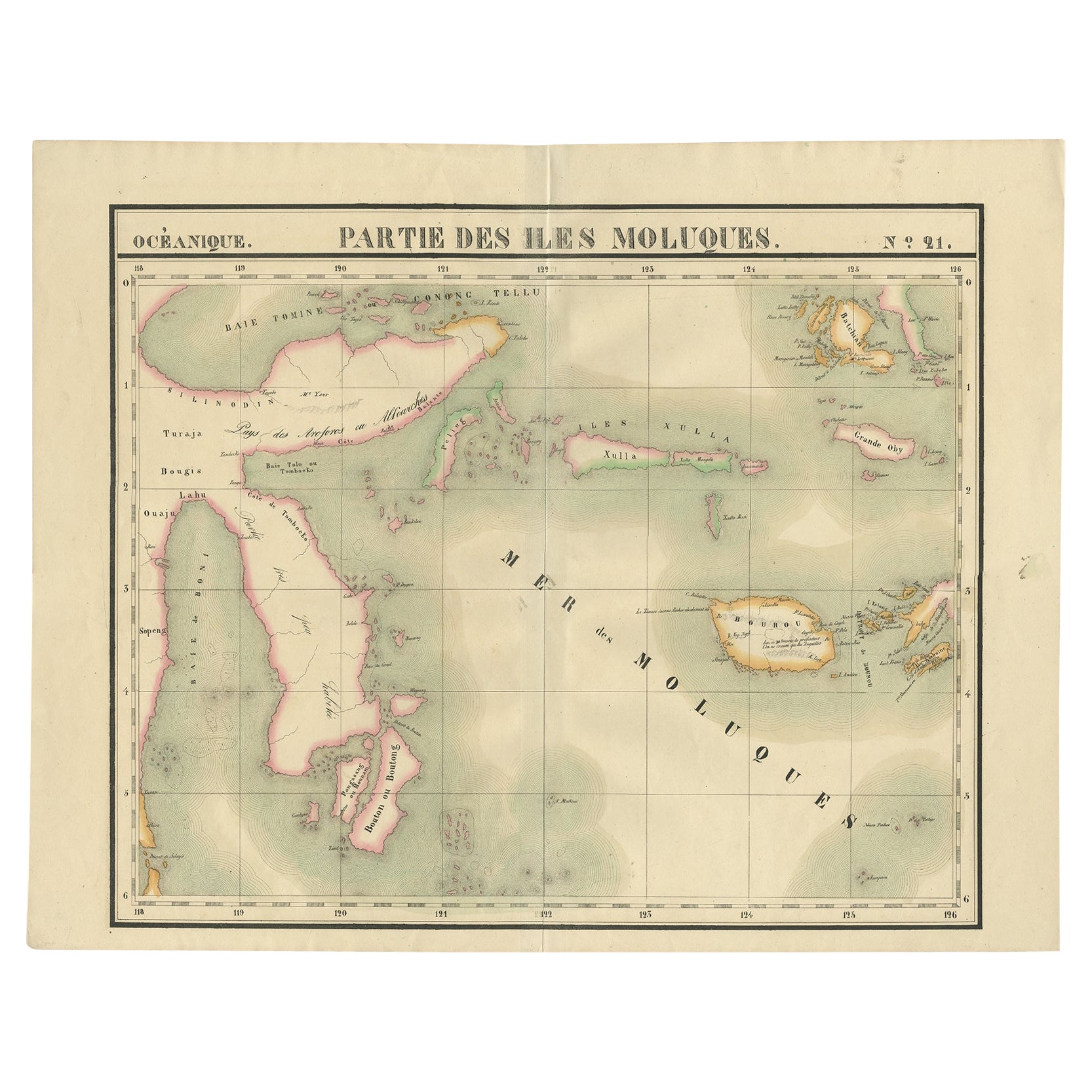
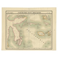
- Old Map of the Moluccas and Part of Sulawesi Indonesia by Vandermaelen, c 1825Located in Langweer, NLAntique map titled 'Partie des Iles Moluques'. Map of a portion of the Moluccas and part of Sulawesi. Includes the Maluku islands Buru, Sula, Bacan and more. Originates from 'Atlas U...Category
Antique 19th Century Maps
MaterialsPaper
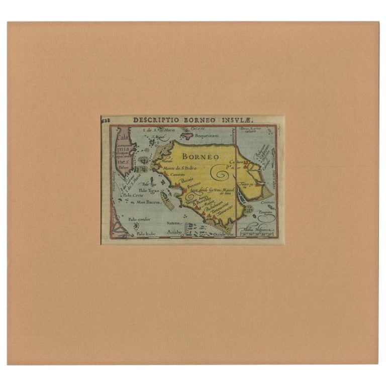
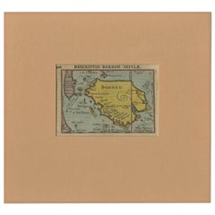
- Antique Miniature Map of Borneo, incl Kalimantan, Indonesia, c.1610Located in Langweer, NLAntique map titled 'Descriptio Borneo Insulae'. Old miniature map of the Indonesian island of Borneo. North is orientated to the left. The Equator runs through the southern part of...Category
Antique 17th Century Maps
MaterialsPaper
- Antique Map of West Kalimantan (Schwaner Mountains), Borneo, Indonesia, 1900Located in Langweer, NLAntique map of West Kalimantan, Borneo. It shows the region of the Schwaner Mountains. This map originates from 'Atlas van Nederlandsch Oost- en West-Indië' by I. Dornseiffen. Arti...Category
20th Century Maps
MaterialsPaper
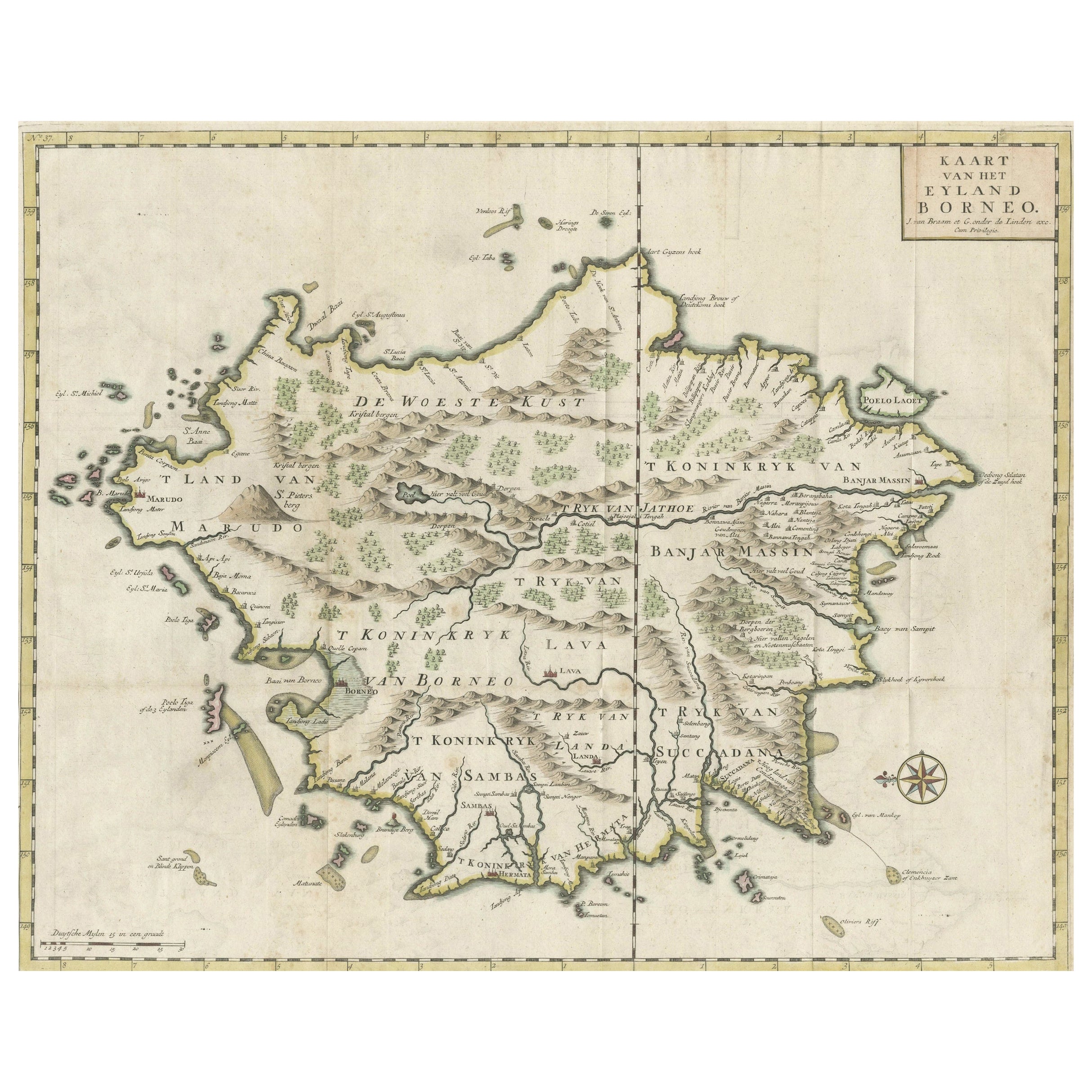
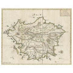
- Old Antique Map of Borneo 'Kalimantan Indonesia, Sabah Malaysia & Brunei'Located in Langweer, NLAntique map titled 'Kaart van het Eyland Borneo'. Original antique map of the island of Borneo. Published 1724-1726 by Joannes van Braam and Gerard Onder de ...Category
Antique Early 18th Century Maps
MaterialsPaper
You May Also Like
- Original Antique Map of Indonesia, 1861Located in St Annes, LancashireGreat map of Indonesia Drawn and engraved by Edward Weller Original color Published in The Weekly Dispatch Atlas, 1861 Repairs to minor e...Category
Antique 1860s English Victorian Maps
MaterialsPaper

- 1844 Map "Russia in Eurpoe, Part II to Part VIII", 7 Maps Ric.r023Located in Norton, MA1844 Map "Russia in Eurpoe, Part II to Part VIII" 7 Maps Ric.r023 Fine, original, steel-engraved Map of Russia in Europe Part II t oPart VIII, by the Society for the Diffusion of Useful Knowledge. Detailed map of the regions to the northeast of Moscow. Including Arkhangel, Vologda, Viatka, Perm, Olonetz, Iaroslavl. The SDUK began its map publishing project under the leadership of Captain Francis Beaufort R.N. in 1829, and published the maps in parts, haltingly, over the next 15 years, completing the series in 1844, finally permitting the publication of a whole atlas. Many of the maps were actually drawn by Beaufort, who at the time was the Hydrographer to the Royal Navy, and all were closely supervised by him. J. & C. Walker worked closely with Beaufort in engraving the maps. Finely engraved, carefully researched, the maps set...Category
Antique 19th Century Unknown Maps
MaterialsPaper
- 1907 Map of Colorado, Antique Topographical Map, by Louis NellLocated in Colorado Springs, COThis highly detailed pocket map is a topographical map of the state of Colorado by Louis Nell from 1907. The map "has been complied from all availabl...Category
Antique Early 1900s American Maps
MaterialsPaper
- 1861 Topographical Map of the District of Columbia, by Boschke, Antique MapLocated in Colorado Springs, COPresented is an original map of Albert Boschke's extremely sought-after "Topographical Map of the District of Columbia Surveyed in the Years 1856 ...Category
Antique 1860s American Historical Memorabilia
MaterialsPaper
- Antique Ikat Pua from Borneo IndonesiaLocated in Atlanta, GAStunning old ceremonial Ikat two-panel seamed Pua. Cotton with natural dye. Collected from Borneo Indonesia. Please call the gallery to make sure this ite...Category
Antique 19th Century Quilts and Blankets
- Antique Map of Italy by Andriveau-Goujon, 1843By Andriveau-GoujonLocated in New York, NYAntique Map of Italy by Andriveau-Goujon, 1843. Map of Italy in two parts by Andriveau-Goujon for the Library of Prince Carini at Palazzo Carini i...Category
Antique 1840s French Maps
MaterialsLinen, Paper


Recently Viewed
View AllMore Ways To Browse
Cambodia Antique Map
Antique Map Singapore
Guyana Antique Map
Antique Map Vietnam
Antique Maps Michigan
Puerto Rico Map
Wisconsin Map
Antique Map Sydney
Antique Maps Sydney
J Beringer
Antique Map Of Michigan
Antique Wisconsin Maps
Bedfordshire Antique Map
Herefordshire Antique Map
Antique Furniture Pondicherry
Antique Indiana Map
Antique Maps Rhode Island
Buckinghamshire Antique Map