Items Similar to Authentic Old Map of Southeast Asia with Original Border Coloring, 1745


Want more images or videos?
Request additional images or videos from the seller
1 of 6
Authentic Old Map of Southeast Asia with Original Border Coloring, 1745
$419.93
$524.9220% Off
£305.71
£382.1420% Off
€352
€44020% Off
CA$572.79
CA$715.9920% Off
A$641.30
A$801.6220% Off
CHF 336.25
CHF 420.3220% Off
MX$7,923.61
MX$9,904.5220% Off
NOK 4,236.99
NOK 5,296.2420% Off
SEK 3,999.55
SEK 4,999.4420% Off
DKK 2,678.88
DKK 3,348.6020% Off
Shipping
Retrieving quote...The 1stDibs Promise:
Authenticity Guarantee,
Money-Back Guarantee,
24-Hour Cancellation
About the Item
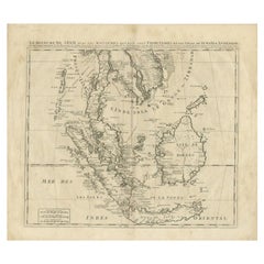
Title: "Kaartje van Oost-Indien na de stelling van den Heer Guillaume de L'Isle"
Translates to "Map of the East-Indies based on the work of Mr. Guillaume de L'Isle." Guillaume de L'Isle was a prominent French cartographer known for his influential maps during the 18th century.
Published by Jacob Keizer and by Jan de Lat
Creator: Keizer, Jacob, active 1706-1750
Size: 17.10 x 24.20cm.
Description:
The map is based on the work of Guillaume de L'Isle and published in 1745, holds historical significance for its representation of the East Indies, particularly for its naming of Australia as 'Nieuw Holland.'
During the 18th century, cartographers like Guillaume de L'Isle played a pivotal role in mapping and understanding the world. Their maps were known for their accuracy and detail, contributing significantly to geographic knowledge during that era.
The designation of Australia as 'Nieuw Holland' (New Holland) on this map is noteworthy as it reflects the historical European exploration and discovery of the Australian continent by Dutch navigators. The Dutch were among the first Europeans to explore parts of Australia's western coast in the 17th century, hence the naming of the landmass as 'New Holland' on some maps during that period.
Maps from this time often also depicted various islands, regions, within the East Indies, including present-day Indonesia, Malaysia, the Philippines, and parts of Southeast Asia.
This map serves as a historical document, offering insights into the cartographic understanding of the East Indies and Australia during the 18th century, showcasing the advancements in mapping and exploration of that period.
- Dimensions:Height: 6.7 in (17 cm)Width: 9.45 in (24 cm)Depth: 0 in (0.02 mm)
- Materials and Techniques:Paper,Engraved
- Period:1740-1749
- Date of Manufacture:1745
- Condition:Very Good. Three folding lines. Study the image carefully.
- Seller Location:Langweer, NL
- Reference Number:Seller: BG-11488-41stDibs: LU3054337461352
About the Seller
5.0
Recognized Seller
These prestigious sellers are industry leaders and represent the highest echelon for item quality and design.
Gold Seller
Premium sellers maintaining a 4.3+ rating and 24-hour response times
Established in 2009
1stDibs seller since 2017
2,478 sales on 1stDibs
Typical response time: 1 hour
- ShippingRetrieving quote...Shipping from: Langweer, Netherlands
- Return Policy
Authenticity Guarantee
In the unlikely event there’s an issue with an item’s authenticity, contact us within 1 year for a full refund. DetailsMoney-Back Guarantee
If your item is not as described, is damaged in transit, or does not arrive, contact us within 7 days for a full refund. Details24-Hour Cancellation
You have a 24-hour grace period in which to reconsider your purchase, with no questions asked.Vetted Professional Sellers
Our world-class sellers must adhere to strict standards for service and quality, maintaining the integrity of our listings.Price-Match Guarantee
If you find that a seller listed the same item for a lower price elsewhere, we’ll match it.Trusted Global Delivery
Our best-in-class carrier network provides specialized shipping options worldwide, including custom delivery.More From This Seller
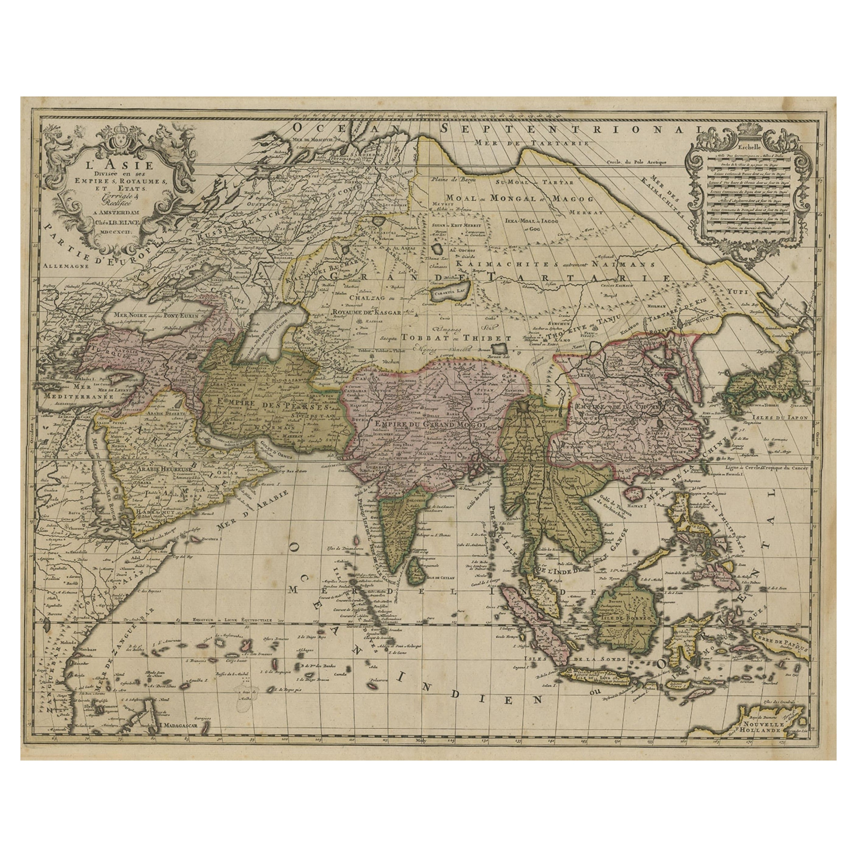
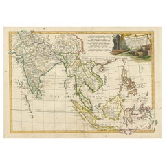
View AllLarge Antique Map of Asia including All of Southeast Asia, c.1792
Located in Langweer, NL
Antique map titled 'L' Asie Divisee en ses Empires, Royaumes, et Etats'. Attractive, large map of Asia including all of Southeast Asia. The cartography is archaic for the period with...
Category
Antique 18th Century Maps
Materials
Paper
$1,431 Sale Price
20% Off
Free Shipping
Antique Map of Southeast Asia by Van Dùren, 1752
Located in Langweer, NL
Antique map titled 'Neue Vorstellung von Indien und China'. Original antique map of Southeast Asia. This map originates from 'Neue Sammlung der merkwürdigsten Reisegeschichten, inson...
Category
Antique Mid-18th Century Maps
Materials
Paper

$429 Sale Price
20% Off
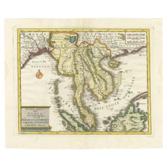
Antique Map of Southeast Asia by Chatelain, c.1732
Located in Langweer, NL
"Antique map titled 'La Royaume de Siam avec les Royaumes qui luy sont Tributaires et les Isles de Sumatra Andemaon'. It shows: Southeast Asia; Borneo, Java, Siam (Thailand), Malacca...
Category
Antique 18th Century Maps
Materials
Paper
$739 Sale Price
20% Off
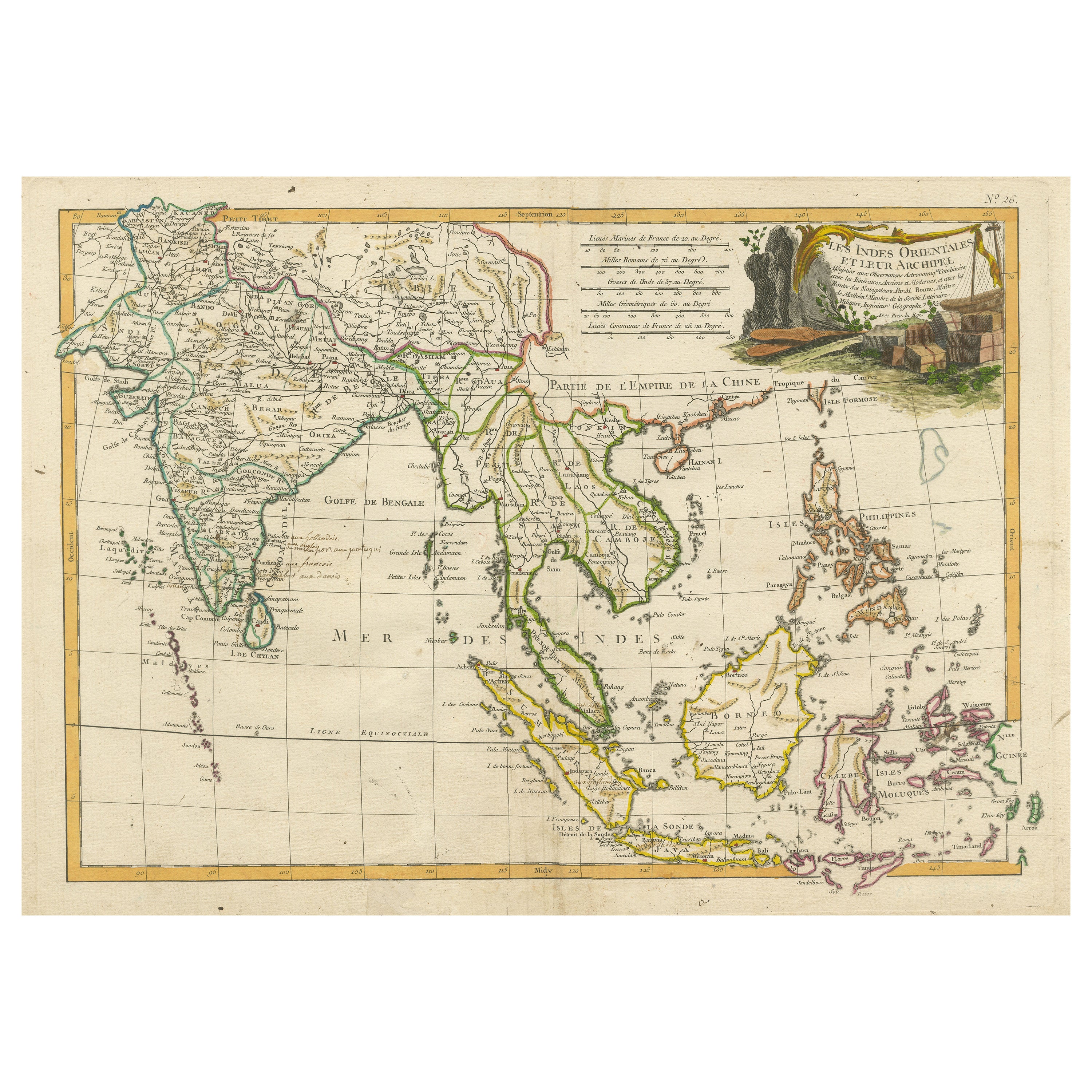
Antique Map of Southeast Asia with Decorative Allegorical Cartouche
Located in Langweer, NL
Antique map titled 'Les Indes Orientales et leur Archipel'. Old map of Southeast Asia, the Straits of Malaca, Philippines, Sumatra, Java, India etc., extending north to Canton and Ma...
Category
Antique Mid-18th Century Maps
Materials
Paper
$897 Sale Price
20% Off
Free Shipping
Antique Map of Southeast Asia by J. Ottens, 1710
Located in Langweer, NL
Antique map titled 'Le Royaume de Siam avec Les Royaumes Qui Luy sont Tributaries'. Influential map of Southeast Asia. Ottens incorporated information provided by the French Jesuits ...
Category
Antique Early 18th Century Maps
Materials
Paper

$1,008 Sale Price
41% Off
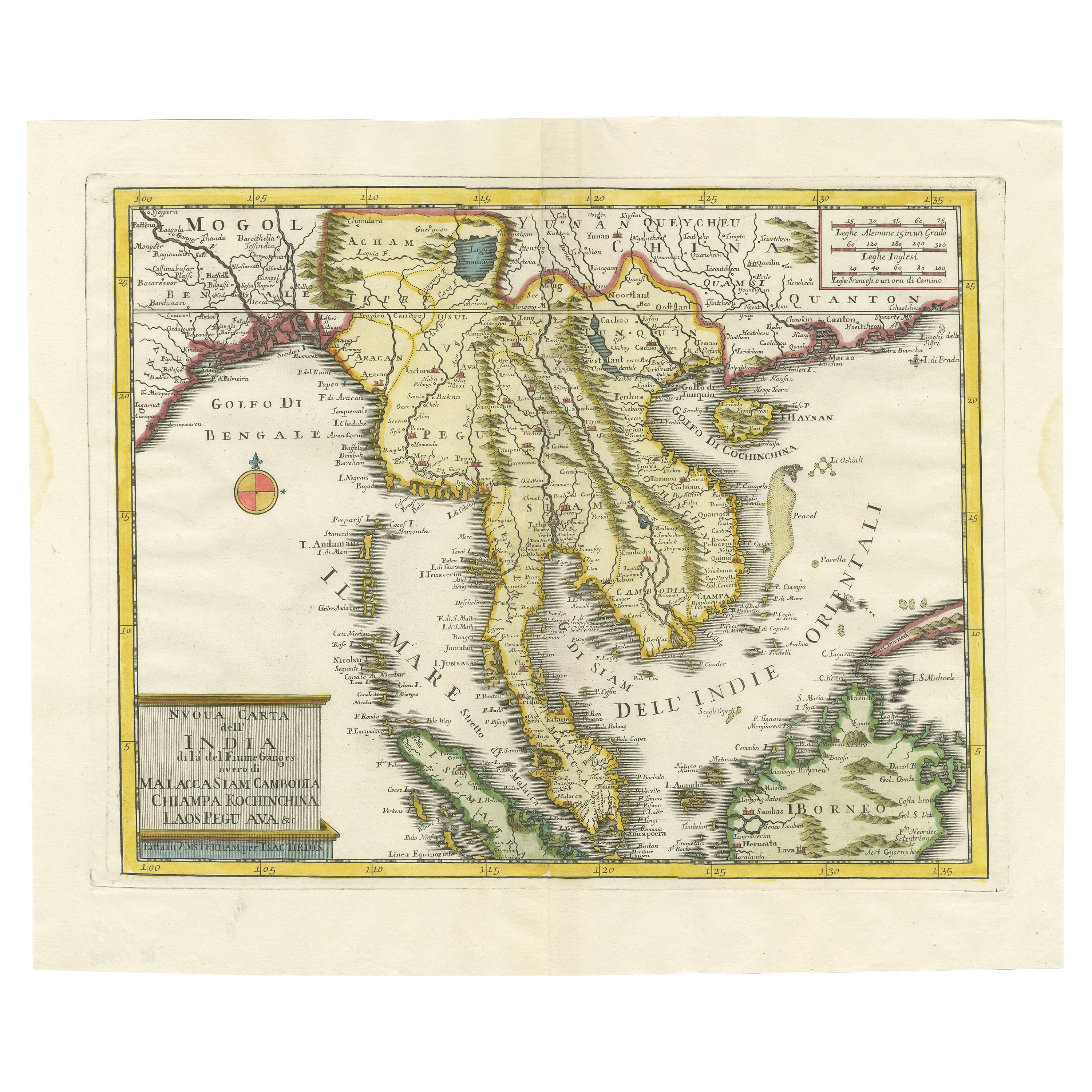
Antique Map of the Region Centered on the Malay Peninsula by Tirion 'c.1760'
Located in Langweer, NL
Antique map titled 'Nuova Carta dell' India (..)'. Decorative map of the region centered on the Malay Peninsula and extending from the Straits of Singapore, Malacca and Borneo in the South to China in the east and the Bay of Bengal...
Category
Antique Mid-18th Century Maps
Materials
Paper
$930 Sale Price
20% Off
You May Also Like
Antique 1803 Italian Map of Asia Including China Indoneseia India
Located in Amsterdam, Noord Holland
Antique 1803 Italian Map of Asia Including China Indoneseia India
Very nice map of Asia. 1803.
Additional information:
Type: Map
Country of Manufacturing: Europe
Period: 19th centu...
Category
Antique 19th Century European Maps
Materials
Paper

$584 Sale Price
20% Off
Antique French Map of Asia Including China Indoneseia India, 1783
Located in Amsterdam, Noord Holland
Very nice map of Asia. 1783 Dedie au Roy.
Additional information:
Country of Manufacturing: Europe
Period: 18th century Qing (1661 - 1912)
Condition: Overall Condition B (Good Used)...
Category
Antique 18th Century European Maps
Materials
Paper

$648 Sale Price
20% Off
Map of the East Indies: An Original 18th Century Hand-colored Map by E. Bowen
Located in Alamo, CA
This is an original 18th century hand-colored map entitled "An Accurate Map of the East Indies Exhibiting the Course of the European Trade both on the Continent and Islands" by Emanu...
Category
Mid-18th Century Old Masters Landscape Prints
Materials
Engraving

Asia Declineatio: A 17th Century Hand-colored Map of Asia by Justus Danckerts
Located in Alamo, CA
This is a scarce 17th century beautifully hand-colored copperplate engraved map of Asia entitled “Exactissima Asiae Delineatio in Praecipuas Regiones Caerterasque Partes divisa et de...
Category
Late 17th Century Old Masters Landscape Prints
Materials
Engraving

Original Antique Map of South East Asia by Thomas Clerk, 1817
Located in St Annes, Lancashire
Great map of South East Asia
Copper-plate engraving
Drawn and engraved by Thomas Clerk, Edinburgh.
Published by Mackenzie And Dent, 1817
Unframed.
Category
Antique 1810s English Maps
Materials
Paper

Large Original Vintage Map of S.E Asia, with a Vignette of Singapore
Located in St Annes, Lancashire
Great map of South East Asia
Original color. Good condition
Published by Alexander Gross
Unframed.
Category
Vintage 1920s English Maps
Materials
Paper
More Ways To Browse
Wheel Barometer
White Deer Mount
White Ironstone Bowl
White Jade Bowl
Wicker Barrel Chair
Wicker Club Chairs Woven
William Gladstone
William Iv Dining Table Rosewood
William Morris Cushion
Windsor Captains Chair
Windsor Chairs Set Of 6
Wmf Brass And Copper
Womb Sofa
Wood Art Collage Brutalist
Wood Carved Bear Bench
Wood Carved Stag Head
Wood Toy Horse On Wheels
Woodworking Workbench