Items Similar to Breda North Brabant Map, Published in 1842 – Antique Dutch Folding Map

Want more images or videos?
Request additional images or videos from the seller
1 of 10
Breda North Brabant Map, Published in 1842 – Antique Dutch Folding Map
$1,660.10
£1,233.59
€1,400
CA$2,297.68
A$2,558.65
CHF 1,335.93
MX$31,002.74
NOK 16,847.46
SEK 15,896.90
DKK 10,659.85
About the Item
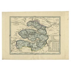
Breda North Brabant Map 1842 – Antique Dutch Folding Map
This antique folding map, titled “Kaart van het Arrondissement Breda in de Provincie Noord-Braband”, depicts the city of Breda and its surrounding arrondissement in the Dutch province of North Brabant. Published around 1842, it provides a highly detailed view of this strategically important region along the Belgian border, dissected into panels and mounted on linen for practical use. The map was surveyed by A. Palier, land surveyor 1st class, and engraved by J. Kraft.
The map shows Breda and neighboring towns including Bergen op Zoom, Roosendaal, Oosterhout, and Tilburg, as well as the surrounding countryside with its network of roads, rivers, canals, and polders. The fortified city of Breda, with its distinctive star-shaped bastions, is prominently engraved, underlining its role as a key military stronghold in Dutch history. Other settlements are carefully marked, while natural features such as woods, heathlands, and waterways are also included.
The southern portion of the map extends into Belgium, reflecting the close ties and sometimes turbulent border between the Netherlands and Belgium in the first half of the 19th century, following Belgian independence in 1830. The western boundary includes Zeeland and Zuid-Beveland, showing the waterways that connect this region to the North Sea.
Engraved with precision, the map is practical yet elegant, offering not only geographic accuracy but also historical significance. Arrondissement maps like this were used for administration, military planning, and travel, and the linen backing allowed for repeated folding and use in the field. Today, they provide a valuable record of mid-19th-century Dutch cartography and local geography.
Condition: Good. Original linen backing with fold lines as issued. Some light toning and minor wear at fold intersections, but image remains clear and paper stable. Marginal foxing in places, consistent with age and handling.
Framing tips: When unfolded, this map makes a striking wall display. A black or dark oak frame with a cream mat will highlight the engraved detail. Consider float-mounting to show the original linen panel structure, emphasizing its historical use as a folding map.
Technique: Engraving on paper, dissected and mounted on linen
Maker: Unknown Dutch provincial survey, c.1850
---
Collector’s note: Folding administrative maps of Dutch provinces and arrondissements from the mid-19th century are relatively scarce. They were produced for official and practical purposes, often in small print runs, and many were heavily used in the field. Maps of Breda are especially appealing to collectors, as the city’s historic role as a fortified stronghold makes it one of the most significant urban centers in Dutch military and political history.*
- Dimensions:Height: 28.35 in (72 cm)Width: 34.65 in (88 cm)Depth: 0.01 in (0.2 mm)
- Materials and Techniques:
- Place of Origin:
- Period:
- Date of Manufacture:1842
- Condition:Condition: Good. Original linen backing with fold lines as issued. Some light toning and minor wear at fold intersections, but image remains clear and paper stable. Marginal foxing in places, consistent with age and handling.
- Seller Location:Langweer, NL
- Reference Number:Seller: BG-133911stDibs: LU3054346391662
About the Seller
5.0
Recognized Seller
These prestigious sellers are industry leaders and represent the highest echelon for item quality and design.
Platinum Seller
Premium sellers with a 4.7+ rating and 24-hour response times
Established in 2009
1stDibs seller since 2017
2,589 sales on 1stDibs
Typical response time: <1 hour
- ShippingRetrieving quote...Shipping from: Langweer, Netherlands
- Return Policy
Authenticity Guarantee
In the unlikely event there’s an issue with an item’s authenticity, contact us within 1 year for a full refund. DetailsMoney-Back Guarantee
If your item is not as described, is damaged in transit, or does not arrive, contact us within 7 days for a full refund. Details24-Hour Cancellation
You have a 24-hour grace period in which to reconsider your purchase, with no questions asked.Vetted Professional Sellers
Our world-class sellers must adhere to strict standards for service and quality, maintaining the integrity of our listings.Price-Match Guarantee
If you find that a seller listed the same item for a lower price elsewhere, we’ll match it.Trusted Global Delivery
Our best-in-class carrier network provides specialized shipping options worldwide, including custom delivery.More From This Seller
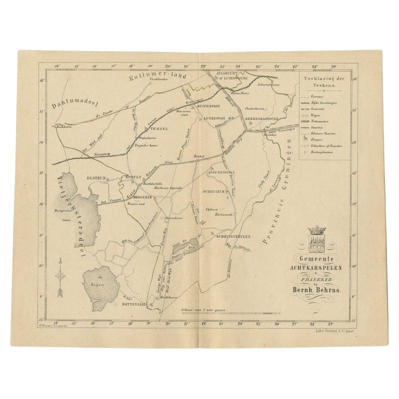
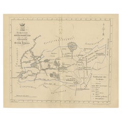
View AllAntique Map of The Dutch Achtkarspelen Township by Behrns, 1861
Located in Langweer, NL
Antique map titled 'Gemeente Achtkarspelen'. Old map depicting the Achtkarspelen township including cities and villages like Buitenpost, Twijzel, Drogeham and Surhuisterveen. This ma...
Category
Antique 19th Century Maps
Materials
Paper
$113 Sale Price
20% Off
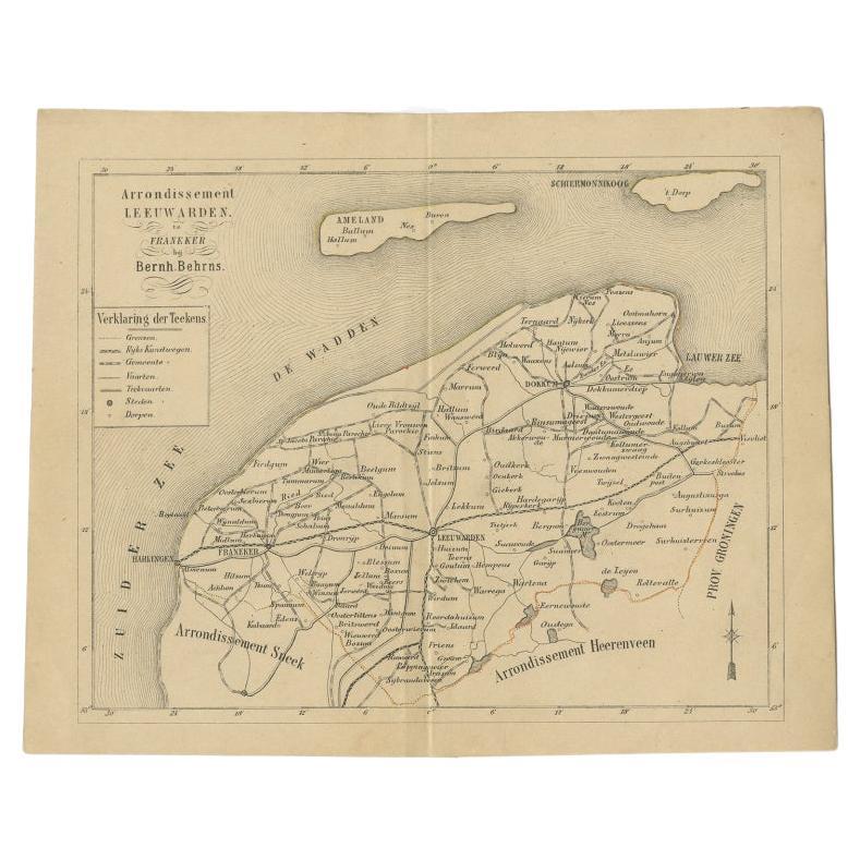
Antique Dutch Map of The Region of Leeuwarden by Behrns, 1861
Located in Langweer, NL
Antique map titled 'Arrondissement Leeuwarden'. Old map depicting the region of Leeuwarden including cities and villages like Franeker, Harlingen, Dokkum and more. This map orginates...
Category
Antique 19th Century Maps
Materials
Paper

$142 Sale Price
20% Off
Antique Map of Frisian Municipality of Achtkarspelen in the Netherlands, 1868
Located in Langweer, NL
Antique map titled 'Provincie Friesland - Gemeente Achtkarspelen'. Map of the township of Achtkarspelen including Buitenpost, Surhuisterveen and many other villages. This map origina...
Category
Antique 19th Century Maps
Materials
Paper
$132 Sale Price
20% Off
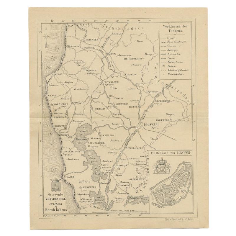
Antique Map of The Wonseradeel Township in Friesland, The Netherlands, 1861
Located in Langweer, NL
Antique map titled 'Gemeente Wonseradeel'. Old map depicting the Wonseradeel township including cities and villages like Kimswerd, Achlum, Arum, Witmarsum, Kornwerd, Hichtum and Bols...
Category
Antique 19th Century Maps
Materials
Paper
$180 Sale Price
20% Off
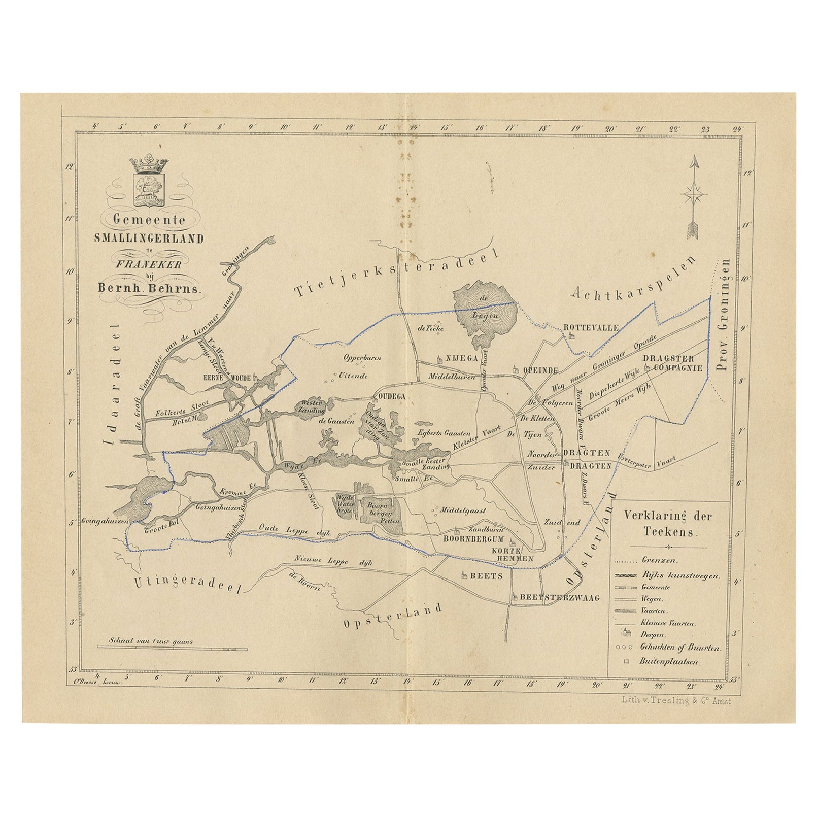
Antique Map of The Dutch Smallingerland Township, 1861
Located in Langweer, NL
Antique map titled 'Gemeente Smallingerland'. Old map depicting the Smallingerland township including cities and villages like Eernewoude, Oudega, Boornbergum, Opeinde and Drachten. ...
Category
Antique 19th Century Maps
Materials
Paper
$94 Sale Price
20% Off
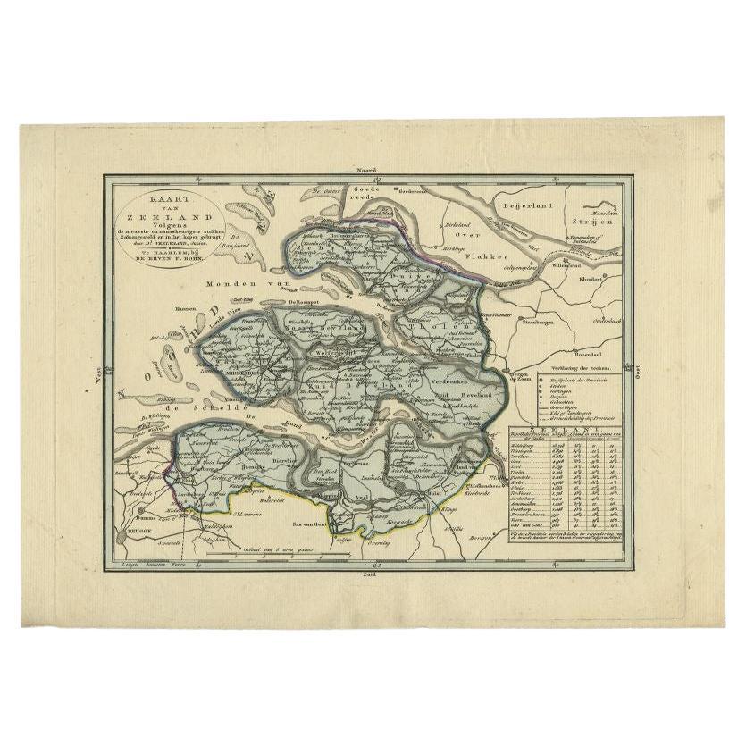
Antique Map of the Province of Zeeland by Veelwaard, C.1840
Located in Langweer, NL
Antique map titled 'Kaart van Zeeland (..).' Uncommon map showing the province of Zeeland in the Netherlands. Source unkown, to be determined. Published circa 1840.
Artists and Eng...
Category
Antique 19th Century Dutch Maps
Materials
Paper
You May Also Like
1752 Vaugoundy Map of Flanders : Belgium, France, and the Netherlands, Ric.a002
Located in Norton, MA
Large Vaugoundy Map of Flanders:
Belgium, France, and the Netherlands
Colored -1752
Ric.a002
Description: This is a 1752 Didier Robert de Vaugondy map of Flanders. The map de...
Category
Antique 17th Century Unknown Maps
Materials
Paper

1851 Map of "Independent Tartary", Ric. R018
Located in Norton, MA
1851 Map of
Independent Tartary
"Russia"
Ric.r018
A highly decorative 1851 map of Independent Tartary by John Tallis and John Rapkin. Covers the regions between the Caspian Sea and Lake Bakquash and between Russia and Afghanistan. These include the ancient Silk Route kingdoms of Khiva, Tartaria, Kokand, and Bokhara. Today this region roughly includes Kazakhstan, Uzbekistan, Turkmenistan, Kyrgyzstan, and Tajikistan. This wonderful map offers a wealth of detail for anyone with an interest in the Central Asian portion of the ancient Silk Road. Identifies various caravan routes, deserts, wells, and stopping points, including the cities of Bokhara and Samarkand. Three vignettes by W. Bragg decorate the map, these including an image of Tartars on a Journey, a horseback Bride Chase, and a tartar camp site. Surrounded by a vine motif border. Engraved by J. Rapkin for John Tallis's 1851 Illustrated Atlas .
Tartary Antique Map...
Category
Antique 19th Century Unknown Maps
Materials
Paper

Original Antique Map or City Plan of Rome, Italy. Circa 1835
Located in St Annes, Lancashire
Nice map of Rome
Drawn and engraved by J.Dower
Published by Orr & Smith. C.1835
Unframed.
Free shipping
Category
Antique 1830s English Maps
Materials
Paper

Original Antique English County Map - Monmouthshire. J & C Walker. 1851
Located in St Annes, Lancashire
Great map of Monmouthshire
Original colour
By J & C Walker
Published by Longman, Rees, Orme, Brown & Co. 1851
Unframed.
Category
Antique 1850s English Other Maps
Materials
Paper

1839 Map of Karte Des "Russischen Reiches in Europa Und Asien" Ric.R0013
Located in Norton, MA
1839 map of Karte Des
"Russischen Reiches in Europa and Asien"
Ric.r013
Map of the European and Asian parts of Russian Empire. Karte der Russischen Reiches in Europa und Asien...
Category
Antique 19th Century Unknown Maps
Materials
Paper

1849 Map of "Europaische Russland", 'Meyer Map of European Russia', Ric. R017
Located in Norton, MA
1849 Map of
"Europaische Russland"
( Meyer Map of European Russia)
Ric.r017
A lovely map of European Russia dating to 1849 by Joseph Meyer. It covers the European portions of...
Category
Antique 19th Century Unknown Maps
Materials
Paper
