Items Similar to Byzantium Nunc Constantinopolis – Braun & Hogenberg View of Istanbul, 1572

Video Loading
Want more images or videos?
Request additional images or videos from the seller
1 of 12
Byzantium Nunc Constantinopolis – Braun & Hogenberg View of Istanbul, 1572
$2,166.02
£1,603.62
€1,800
CA$2,999.01
A$3,274.20
CHF 1,716.53
MX$39,766.46
NOK 21,436.67
SEK 20,241.94
DKK 13,703.78
About the Item
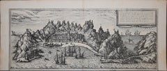
Byzantium Nunc Constantinopolis – Braun & Hogenberg View of Istanbul, Cologne, 1572
This iconic 16th-century bird’s-eye view titled “Byzantium Nunc Constantinopolis” presents the city of Constantinople (modern-day Istanbul) in extraordinary detail, as it appeared in the early Ottoman period. It was published by Georg Braun and Frans Hogenberg in the first volume of their celebrated city atlas Civitates Orbis Terrarum (Cologne, 1572), the most important and ambitious city-view collection of the Renaissance.
The engraving shows the city from the Sea of Marmara, looking northward across the Golden Horn. The walled peninsula of old Constantinople is densely filled with red-roofed buildings, interspersed with domes and minarets. Prominent features include the Hagia Sophia, the Topkapi complex, and the bustling harbor areas. Across the water lies the district of Pera (Galata), with its own fortifications and winding streets. The sea is animated with richly detailed ships, galleys, and trading vessels, underlining the city's status as a maritime and cultural crossroads.
The foreground features a group of mounted Ottoman figures—likely representing Sultan Selim II and his court—offering a theatrical introduction to the scene and emphasizing the imperial grandeur of the city under Ottoman rule. The background is framed by lush hills and careful topographical detail, creating a deep and immersive composition.
This engraving is hand-colored, likely in the 16th or early 17th century, preserving the rich visual appeal typical of deluxe copies of the 'Civitates'. Each building, tree, and wall is rendered with intricate care, making this not only a work of cartography but also a decorative and historical artifact of great cultural significance.
Condition: Good overall. Age-related foxing and browning present, particularly in the margins, but the paper remains strong and stable. Early hand-coloring is well-preserved and still vibrant. No loss of image or text. Horizontal centerfold as issued.
Framing tips: This important map deserves a museum-quality mount, ideally in a walnut or gold frame with an archival off-white or antique-cream mat. UV-protective glass is recommended to preserve the original color.
Technique: Copperplate engraving with original hand-coloring
Maker: Georg Braun & Frans Hogenberg, Cologne, 1572
From: *Civitates Orbis Terrarum*, Volume I
- Dimensions:Height: 15.75 in (40 cm)Width: 21.26 in (54 cm)Depth: 0.01 in (0.2 mm)
- Materials and Techniques:Paper,Engraved
- Place of Origin:
- Period:
- Date of Manufacture:circa 1572
- Condition:Condition: Good overall. Age-related foxing and browning present, particularly in the margins, but the paper remains strong and stable. Early hand-coloring is well-preserved and still vibrant. No loss of image or text. Horizontal centerfold as issued.
- Seller Location:Langweer, NL
- Reference Number:Seller: BG-138991stDibs: LU3054346175072
About the Seller
5.0
Recognized Seller
These prestigious sellers are industry leaders and represent the highest echelon for item quality and design.
Platinum Seller
Premium sellers with a 4.7+ rating and 24-hour response times
Established in 2009
1stDibs seller since 2017
2,641 sales on 1stDibs
Typical response time: <1 hour
- ShippingRetrieving quote...Shipping from: Langweer, Netherlands
- Return Policy
Authenticity Guarantee
In the unlikely event there’s an issue with an item’s authenticity, contact us within 1 year for a full refund. DetailsMoney-Back Guarantee
If your item is not as described, is damaged in transit, or does not arrive, contact us within 7 days for a full refund. Details24-Hour Cancellation
You have a 24-hour grace period in which to reconsider your purchase, with no questions asked.Vetted Professional Sellers
Our world-class sellers must adhere to strict standards for service and quality, maintaining the integrity of our listings.Price-Match Guarantee
If you find that a seller listed the same item for a lower price elsewhere, we’ll match it.Trusted Global Delivery
Our best-in-class carrier network provides specialized shipping options worldwide, including custom delivery.More From This Seller
View AllConstantinople (Istanbul) – City View by Werner and Gläser, Augsburg ca.1730
Located in Langweer, NL
Constantinople (Istanbul) – Panoramic City View by Werner and Gläser, Augsburg c.1730
This striking hand-colored copper engraving offers a grand panoramic view of Constantinople (mo...
Category
Antique Early 18th Century German Maps
Materials
Paper

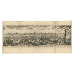
Constantinople – Panoramic Engraving by Matthäus Merian the Elder, 1635
Located in Langweer, NL
Constantinople – Panoramic Engraving by Matthäus Merian the Elder, Frankfurt, 1635
This finely detailed copperplate engraving presents a sweeping bird’s-eye view of Constantinople (...
Category
Antique Early 17th Century German Maps
Materials
Paper
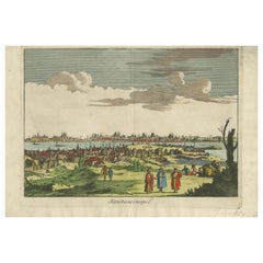
Konstantinopel – Panoramic View of Istanbul by François Halma, 1705
Located in Langweer, NL
Konstantinopel – Panoramic View of Istanbul by François Halma, 1705
This engaging hand-colored engraving of “Konstantinopel” offers a sweeping panoramic view of 18th-century Istanbu...
Category
Antique Early 18th Century Dutch Maps
Materials
Paper
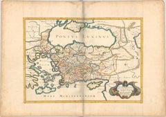
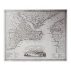
1667 Melchior Tavernier Map of the Patriarchate of Constantinople – Black Sea
Located in Langweer, NL
This 1667 map titled "Patriarchatus Constantinopolitani Geographica Descriptio" was crafted by renowned French cartographer Melchior Tavernier, who was a prominent map engraver during the 17th century. This rare and historically significant map focuses on the territories under the ecclesiastical jurisdiction of the Patriarchate of Constantinople, one of the most important centers of the Eastern Orthodox Church.
It covers regions around the Black Sea (Pontus Euxinus), parts of Greece, and adjacent areas in Asia Minor and the Balkans, which were historically vital during the Byzantine and Ottoman Empires. The map is filled with ancient place names, making it a valuable resource for both historical and cartographic enthusiasts.
Key Features:
- Antique ecclesiastical map illustrating the influence of the Orthodox Patriarchate of Constantinople in the 17th century.
- Features beautifully detailed ancient coastlines, rivers, and terrains, providing a comprehensive geographical view of the region.
- Rich with historic place names - like Byzantium, Nicomedia, Nicaea, Cyzicus, Bithynia, Pontus, Macedonia, and Thrace - that date back to the classical era, offering insights into the ancient geography of the eastern Mediterranean.
- A finely engraved strapwork cartouche in the lower right corner with Baroque-style decoration, featuring two putti (cherubic figures) – a hallmark of 17th-century map art.
- The map extends to include the Mediterranean Sea (Mare Mediterraneum) to the south and the Black Sea to the north, highlighting its ecclesiastical and geopolitical significance.
- Original hand coloring may still be present, enhancing the decorative appeal for collectors of antique maps.
This rare map offers a unique perspective on the religious influence and historical geography of the Eastern Mediterranean during the late 17th century. It would appeal to collectors interested in:
- **Byzantine history**
- **Ottoman Empire**
- **Eastern Orthodox Church**
- **Antique cartography...
Category
Antique 1660s French Maps
Materials
Paper
$657 Sale Price
30% Off
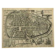
Antique Map of the City of Rotterdam by Guicciardini, C.1600
Located in Langweer, NL
Antique map titled 'Rotterdam'. Bird's eye view plan of Rotterdam in the province of Zuid-Holland, The Netherlands, Holland. This map originates from one of the editions of 'Discritt...
Category
Antique 17th Century Maps
Materials
Paper
$380 Sale Price
20% Off
Antique Map of the City of Kampen by Guicciardini, 1613
Located in Langweer, NL
Antique map titled 'Urbis Campensis (..)'. Plan of the city of Kampen, the Netherlands. This map originates from the 1613 edition of 'Discrittione di tutti i Paesi Bassi', by L. Guic...
Category
Antique 17th Century Maps
Materials
Paper

You May Also Like
1597 German Map of Alexandria by Georg Braun and Frans Hogenberg
By Georg Braun and Frans Hogenberg
Located in Chapel Hill, NC
1597 Map of Alexandria by Georg Braun and Frans Hogenberg, Germany. From "Civitas Orbis Terrarum", part 2, published in Cologne by Bertram Buchholz. Printed in 2 parts. Title: "Alexa...
Category
Antique 16th Century German Renaissance Maps
Materials
Paper

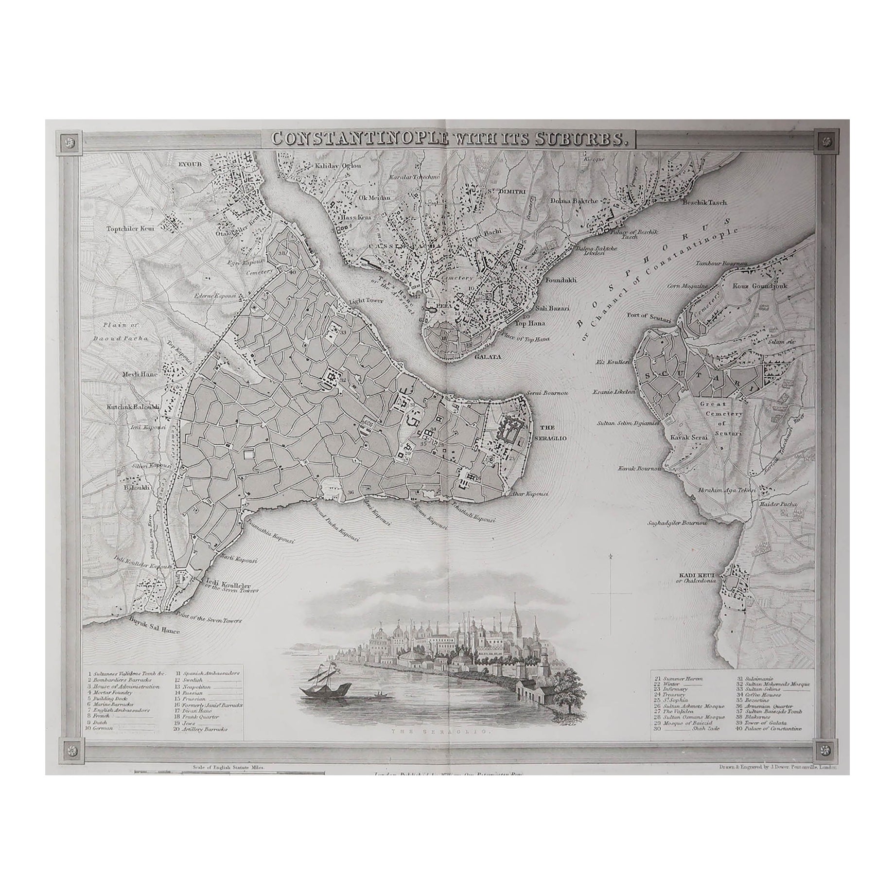
Original Antique Map or City Plan of Istanbul, Turkey. Circa 1835
Located in St Annes, Lancashire
Nice map of Istanbul
Drawn and engraved by J.Dower
Published by Orr & Smith. C.1835
Unframed.
Free shipping
Category
Antique 1830s English Maps
Materials
Paper
Aden, Map from "Civitates Orbis Terrarum" - by F. Hogenberg - 1575
By Franz Hogenberg
Located in Roma, IT
Braun G., Hogenberg F., Aden, from the collection Civitates Orbis Terrarum, Cologne, T. Graminaeus, 1572-1617.
Good conditions except some stains on margins and a central fold.
The ...
Category
16th Century Figurative Prints
Materials
Etching, Aquatint
Burdigala, Map from "Civitates Orbis Terrarum" - by F.Hogenberg - 1575
By Franz Hogenberg
Located in Roma, IT
"Burdigala", from the collection "Civitates Orbis Terrarum", Cologne, T. Graminaeus, 1575.
The “Civitates Orbis Terrarum” (Atlas of Cities of the World) was the second oldest prin...
Category
16th Century Figurative Prints
Materials
Etching, Aquatint

Map of Antwerp - Etching by G.Braun and F. Hogenberg -Late 16th century
By Franz Hogenberg
Located in Roma, IT
This Map of Anverpia is an original etching hand colored realized by George Braun and Franz Hogenberg as part of the famous Atlas "Civitates Orbis Ter...
Category
16th Century Old Masters Figurative Prints
Materials
Etching

Map of Nijmegen - Etching by G. Braun and F. Hogenberg - Late 16th Century
By Franz Hogenberg
Located in Roma, IT
This map of Noviomagvs is an original etching realized by Georg Braun and Franz Hogenberg as part of the famous series "Civitates Orbis Terrarum".
The state of preservation of the ...
Category
16th Century Figurative Prints
Materials
Etching

More Ways To Browse
Istanbul Antique
16th Century German
Ottoman Sultan
Roof Dome
Galley Ship
Pair Of Danish Chairs
Veneer Dining Tables
1970 Italian Armchair
Furniture Uk
House Of Denmark Table And Chairs
Louis Marble Top Side Table
Antique Russian Rugs
Baker Furniture By
For Kids
Sterling Silver Flatware Set Service For 12
Tufted Bar
Pair Of French Antique Armchairs
1970s Brass Glass Coffee Table