Items Similar to Canada Antique Railroad Map c.1888 – British America, Cities & Regions

Video Loading
Want more images or videos?
Request additional images or videos from the seller
1 of 11
Canada Antique Railroad Map c.1888 – British America, Cities & Regions
$548.74
£405.69
€460
CA$754.78
A$838.99
CHF 439.78
MX$10,246.07
NOK 5,490.39
SEK 5,165.43
DKK 3,501.97
About the Item
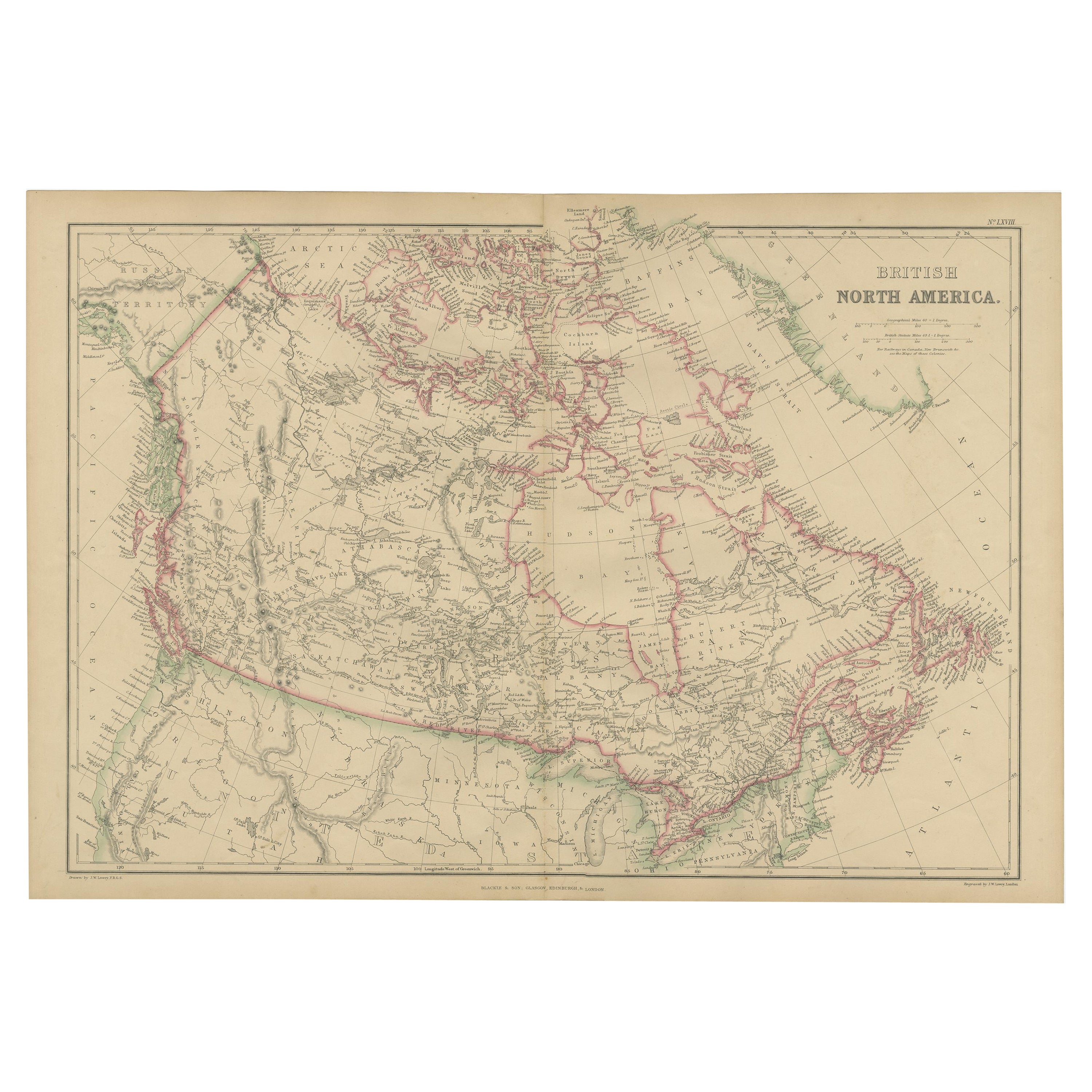
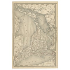
Antique Map of Canada – Rand McNally’s British America, circa 1888
This antique map titled “Rand, McNally & Co.’s British America” was published around 1888 and depicts the full extent of Canada as it stood in the late 19th century. It covers the vast Dominion of Canada from the Pacific Ocean to Newfoundland and Labrador, and from the United States border to the Arctic archipelago.
The map divides the provinces and territories in outline color, with Manitoba, Ontario, Quebec, the Maritime Provinces, British Columbia, and the North-West Territories all carefully delineated. Hudson Bay dominates the center, surrounded by the immense northern territories, still sparsely mapped at the time. Railroads, prominently shown in the southern provinces, illustrate the progress of Canada’s transportation network, especially the Canadian Pacific Railway, which linked east and west for the first time in the 1880s.
The geographical detail includes rivers, mountain ranges, and settlement clusters. Areas such as “Labrador,” “Hudson’s Bay Territory,” and “Dominion of Canada” reflect the cartographic vocabulary of the period. This map captures Canada at a formative moment, shortly after Confederation (1867) and during its westward expansion, making it both historically significant and highly decorative.
Condition report:
Very good condition with light toning and a visible center fold as issued. Plate impression clear. Mild handling marks to the margins, not affecting the printed area.
Framing tips:
This map works well as the centerpiece of a Canadian collection. A walnut or cherry wood frame with a cream mat enhances its period style. A double mat with ivory and muted green accents highlights both the engraved detail and the pastel coloring of the provinces.
Technique: Lithograph with original outline color
Maker: Rand, McNally & Co., Chicago, circa 1888
- Dimensions:Height: 14.18 in (36 cm)Width: 20.67 in (52.5 cm)Depth: 0.01 in (0.2 mm)
- Materials and Techniques:Paper,Engraved
- Place of Origin:
- Period:
- Date of Manufacture:1888
- Condition:Good condition with light toning and a visible center fold as issued. Plate impression clear. Mild handling marks to the margins, not affecting the printed area.
- Seller Location:Langweer, NL
- Reference Number:Seller: BG-12794-51stDibs: LU3054346476012
About the Seller
5.0
Recognized Seller
These prestigious sellers are industry leaders and represent the highest echelon for item quality and design.
Platinum Seller
Premium sellers with a 4.7+ rating and 24-hour response times
Established in 2009
1stDibs seller since 2017
2,607 sales on 1stDibs
Typical response time: <1 hour
- ShippingRetrieving quote...Shipping from: Langweer, Netherlands
- Return Policy
Authenticity Guarantee
In the unlikely event there’s an issue with an item’s authenticity, contact us within 1 year for a full refund. DetailsMoney-Back Guarantee
If your item is not as described, is damaged in transit, or does not arrive, contact us within 7 days for a full refund. Details24-Hour Cancellation
You have a 24-hour grace period in which to reconsider your purchase, with no questions asked.Vetted Professional Sellers
Our world-class sellers must adhere to strict standards for service and quality, maintaining the integrity of our listings.Price-Match Guarantee
If you find that a seller listed the same item for a lower price elsewhere, we’ll match it.Trusted Global Delivery
Our best-in-class carrier network provides specialized shipping options worldwide, including custom delivery.More From This Seller
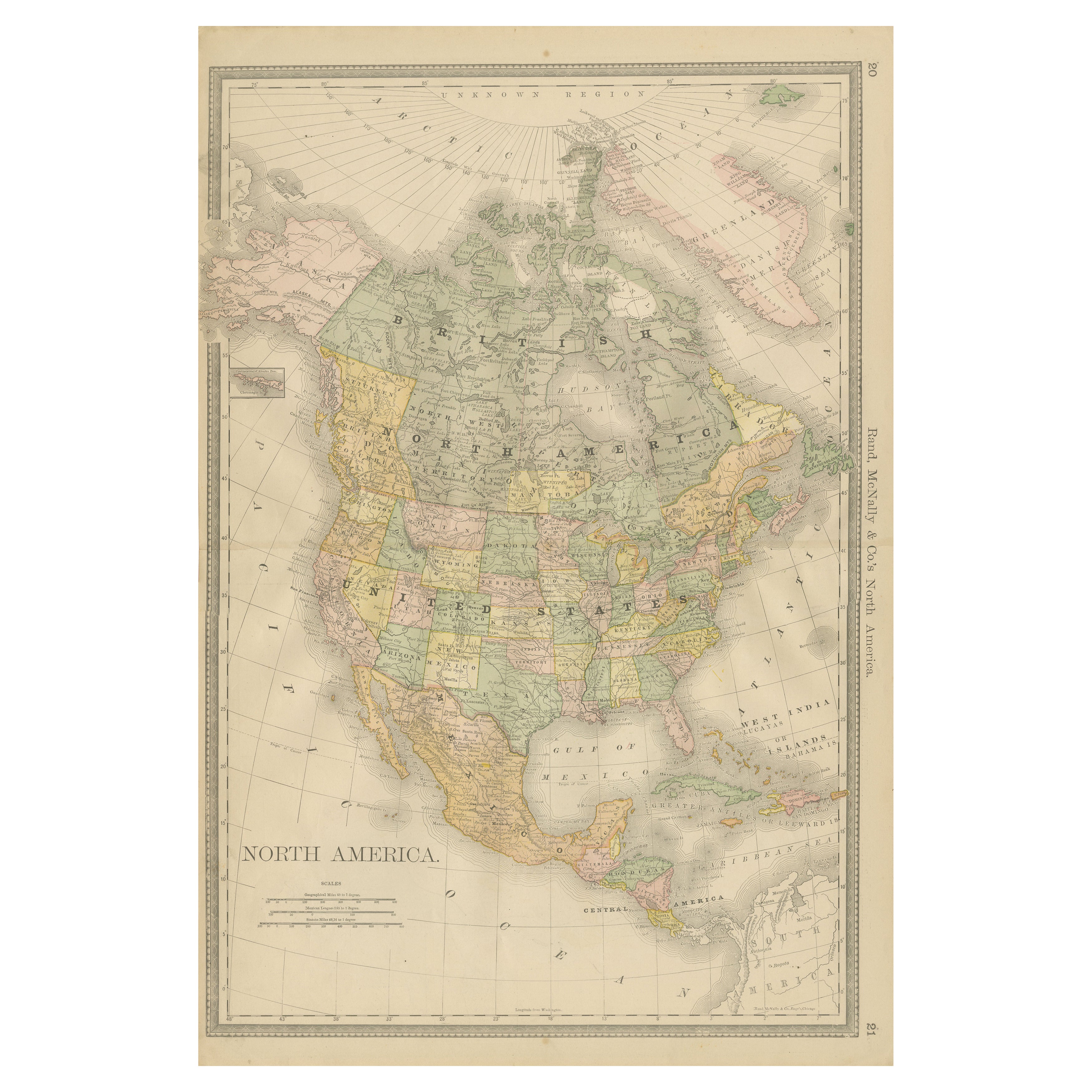
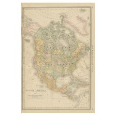
View AllNorth America Antique Railroad Map c.1888 – U.S., Canada & Mexico
Located in Langweer, NL
Antique Map of North America – Rand McNally, circa 1888
This antique map of North America, published by Rand, McNally & Co. circa 1888, offers a comprehensive view of the continent ...
Category
Antique Late 19th Century American Maps
Materials
Paper
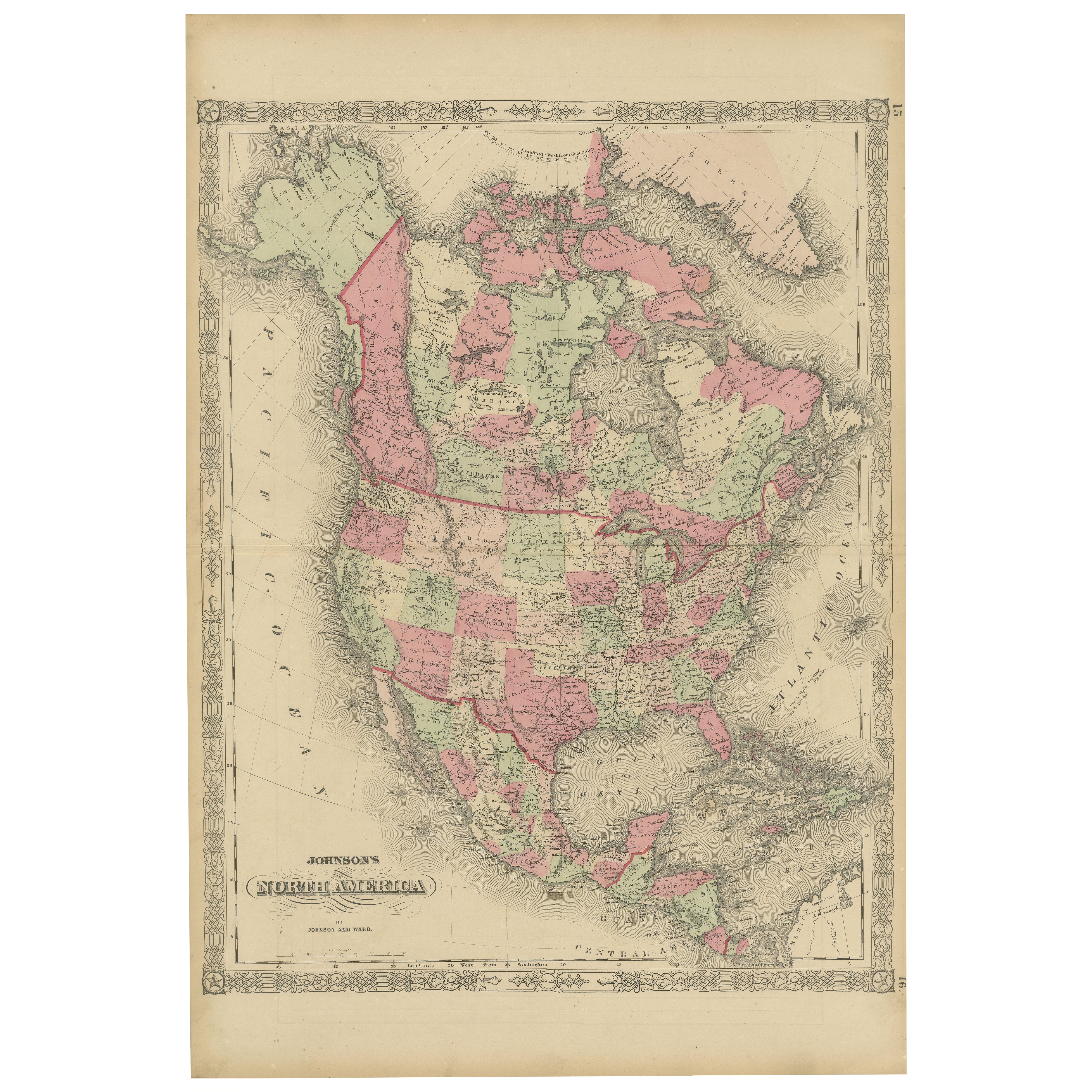
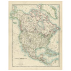
Rare 1864 Civil War Era Map of North America with Detailed Borders
Located in Langweer, NL
Title: Rare 1864 Civil War Era Map of North America with Detailed Borders
Description: This remarkable antique map, titled "Johnson's North America," was published in 1864 by Johnso...
Category
Antique 1860s Maps
Materials
Paper

Explore North America in 1903 - Intricately Detailed Antique Map
Located in Langweer, NL
North America, 1903 - A Colorful Historical Map with Detailed Borders
This attractive map of North America was engraved, printed, and published by W. & A.K. Johnston in 1903. A wond...
Category
Early 20th Century Maps
Materials
Paper
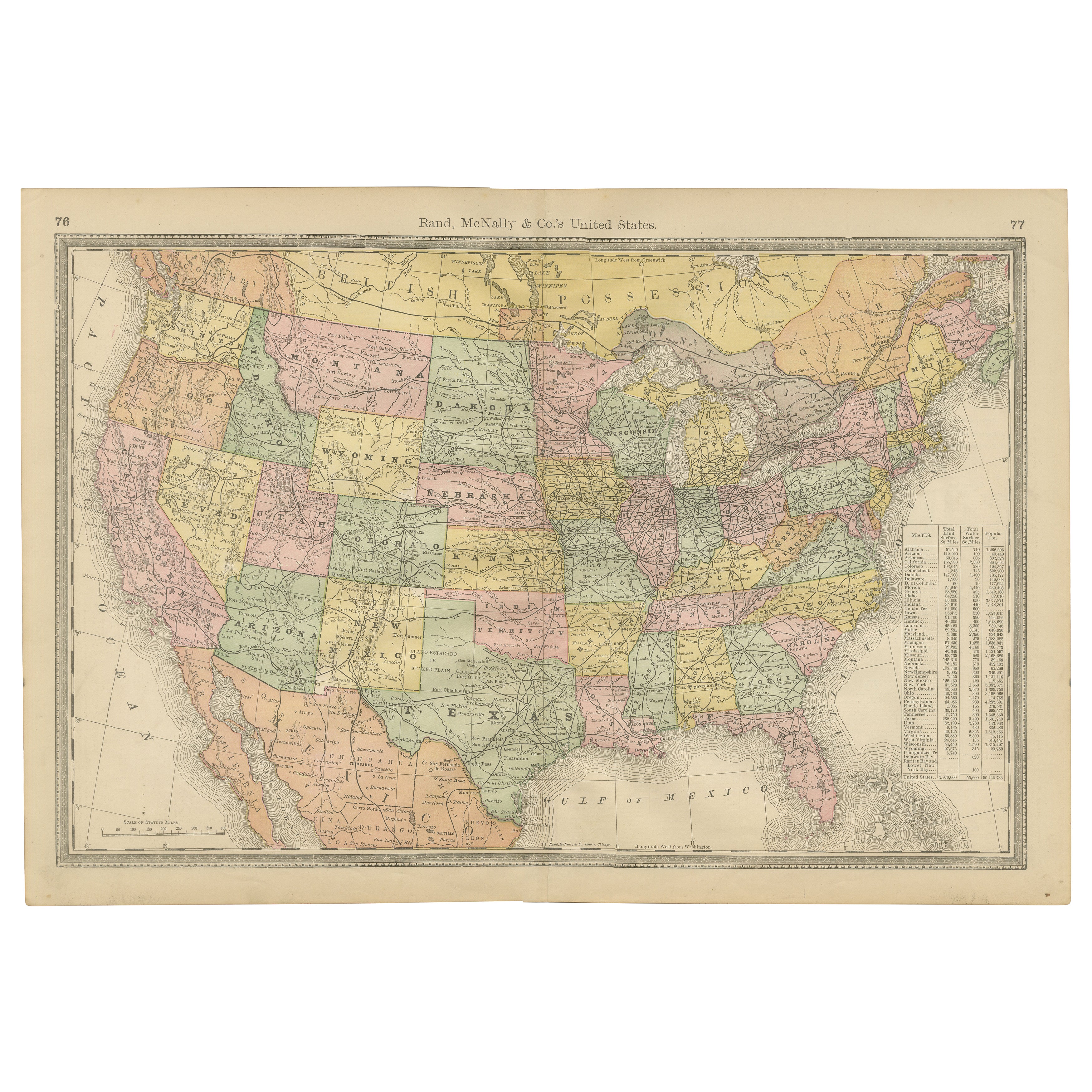
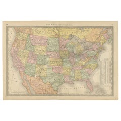
United States Antique Map c.1888 – Railroads, Territories & State Stats
Located in Langweer, NL
Antique Map of the United States – Rand McNally, circa 1888
This antique map of the United States was published by Rand, McNally & Co. around 1888. It presents a colorful overview o...
Category
Antique Late 19th Century American Maps
Materials
Paper
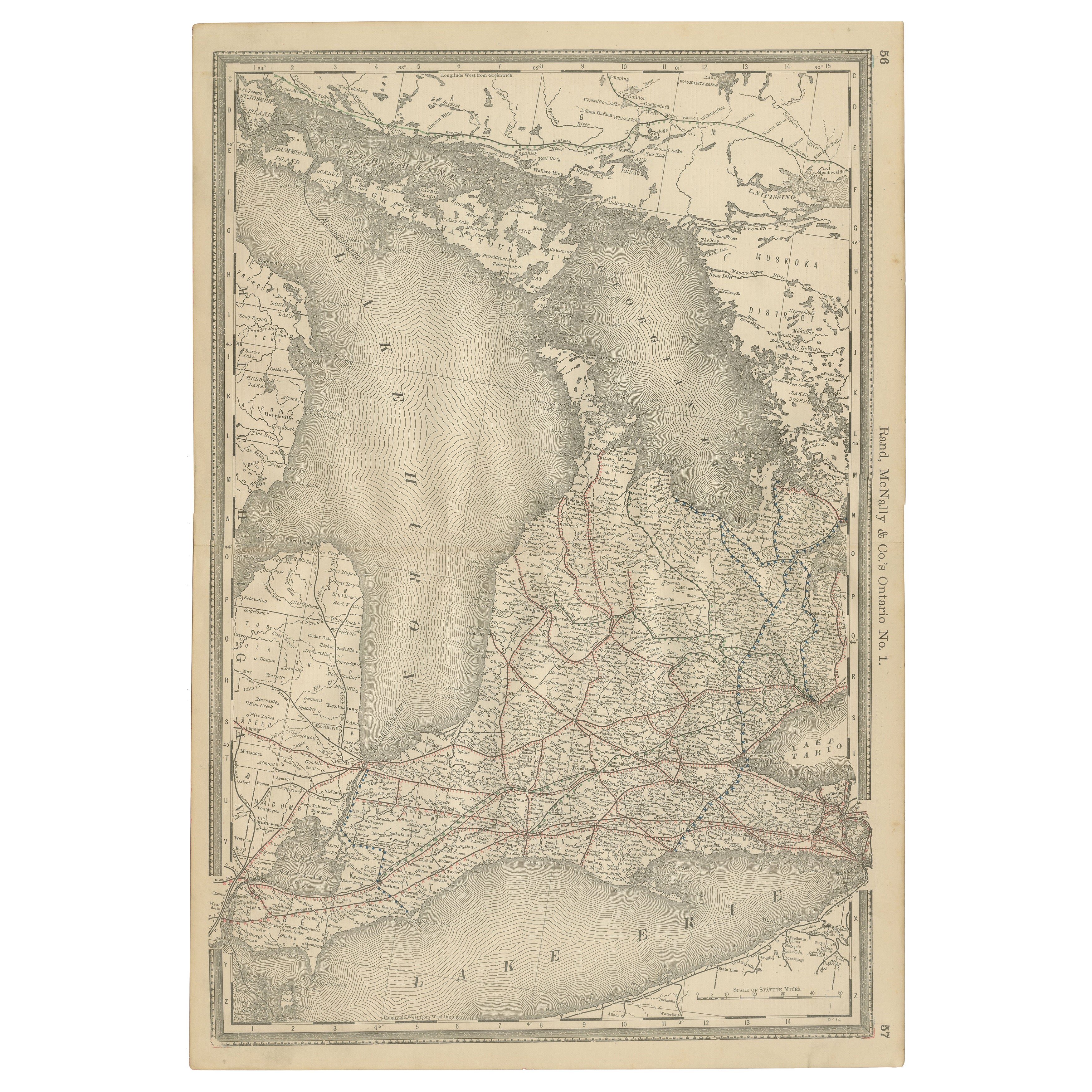
Ontario Antique Map c.1888 – Western Counties, Heartland Province Railroads
Located in Langweer, NL
Antique Map of Western Ontario, Canada – Rand McNally, circa 1888
This antique map of western Ontario was published by Rand, McNally & Co. around 1888. Labeled “Ontario No. 1,” it p...
Category
Antique Late 19th Century American Maps
Materials
Paper
Antique Map of British North America by W. G. Blackie, 1859
Located in Langweer, NL
Antique map titled 'British North America'. Original antique map of British North America. This map originates from ‘The Imperial Atlas of Mode...
Category
Antique Mid-19th Century Maps
Materials
Paper

$238 Sale Price
20% Off
You May Also Like
North America. Century Atlas antique vintage map
Located in Melbourne, Victoria
'The Century Atlas. North America'
Original antique map, 1903.
Central fold as issued. Map name and number printed on the reverse corners.
Sheet 40cm by 29.5cm.
Category
Early 20th Century Victorian More Prints
Materials
Lithograph

Canada and Newfoundland. Century Atlas antique vintage map
Located in Melbourne, Victoria
'The Century Atlas. Dominion of Canada and Newfoundland.'
Original antique map, 1903.
Central fold as issued. Map name and number printed on the reverse corners.
Sheet 29.5cm by 40...
Category
Early 20th Century Victorian More Prints
Materials
Lithograph

Manitoba, British Columbia and NW Territories, Canada. Century Atlas antique map
Located in Melbourne, Victoria
'The Century Atlas. Manitoba, British Columbia and the Northwest Territories, Canada, North America.'
Original antique map, 1903.
Central fold as issued. Map name and number printe...
Category
Early 20th Century Victorian More Prints
Materials
Lithograph

Large Original Vintage Map of North America, circa 1920
Located in St Annes, Lancashire
Great map of North America
Original color. Good condition
Published by Alexander Gross
Unframed.
Category
Vintage 1920s English Edwardian Maps
Materials
Paper

Original Antique Map of North America by Dower, circa 1835
Located in St Annes, Lancashire
Nice map of North America
Drawn and engraved by J.Dower
Published by Orr & Smith. C.1835
Unframed.
Free shipping
Category
Antique 1830s English Maps
Materials
Paper

Original Antique Map of The United States of America by Dower, circa 1835
Located in St Annes, Lancashire
Nice map of the USA
Drawn and engraved by J.Dower
Published by Orr & Smith. C.1835
Unframed.
Free shipping
Category
Antique 1830s English Maps
Materials
Paper
