Items Similar to Decorative Hand-Colored Antique Map of Groningen in the Netherlands, ca.1730


Want more images or videos?
Request additional images or videos from the seller
1 of 5
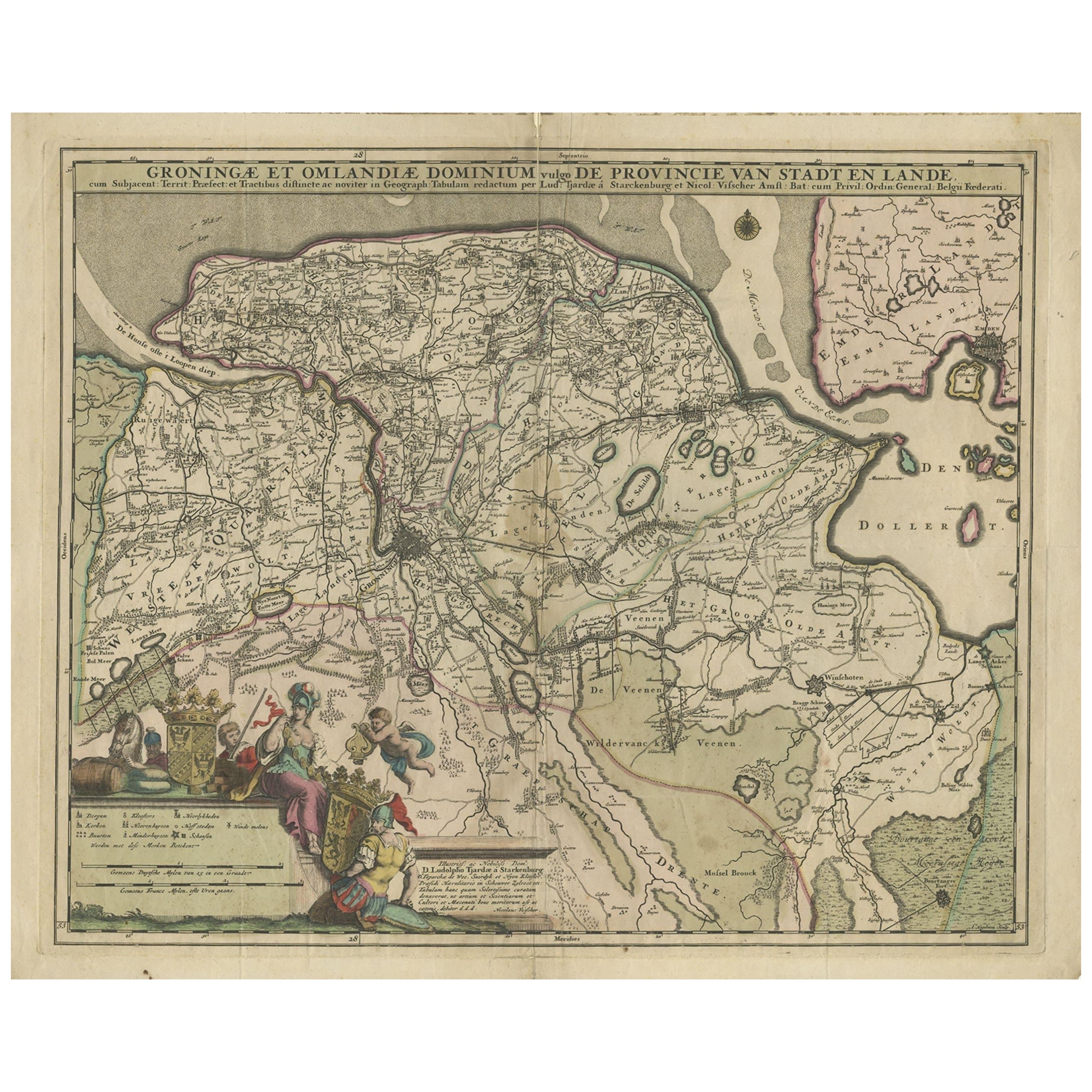
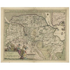
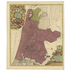
Decorative Hand-Colored Antique Map of Groningen in the Netherlands, ca.1730
About the Item
Antique print, titled: 'Groningae et Omlandiae Dominium vulgo de Provincie van Stadt en Lande (…) ' - This map shows Groningen, the Netherlands. Lower left scale sticks in the decorative cartouche. Originally published after 1681 by Nicolaes Visscher. This ed. re-published by Petrus Schenk Jr. c. 1730.
Artists and Engravers: A. Hoogenboom after D. Ludolpho Tjardae a Starkenburg. Publisher: Petrus Schenk Jr.
The Visscher family were art and map dealers in Amsterdam during the 17th century. Funded by C. J. Visscher (1587-1652), the business was continued by his son and grandson both named Nicolas. Nicolas Visscher I was born 1618 in Wenns, Austria. He died 1679 in Linz. After the death of Nicolas II, his widow passed the business to Pieter Schenk. Pieter Schenk / Petrus Schenck ( 1660-1718/19) was born in Germany, but settled in Amsterdam where he first became a pupil of Gerard Valck, the engraver. In 1687 he married Valck's sister and thereafter the Schenk and Valck families were active over a long period with a wide range of interests as print sellers, publishers of books, maps, topographical and architectural drawings and globes. Although they produced some original maps, most of their atlases consisted of printings from revised and re-worked plates originally by Jansson, the Visschers, the Sansons and others. Peter Schenk the Younger (1693-1775) was a Dutch engraver and map publisher active in Amsterdam and Leipzig.
Condition: Good, given age. Original middle fold, as issued. Paper separation at lower and top middle fold, backed. Vertical crease in right part of print, near middle fold. General age-related toning and/or occasional minor defects from handling. Please study scan carefully.
- Dimensions:Height: 21.66 in (55 cm)Width: 25.71 in (65.3 cm)Depth: 0 in (0.02 mm)
- Materials and Techniques:
- Period:1730-1739
- Date of Manufacture:circa 1730
- Condition:Original middle fold, as issued. Paper separation at lower and top middle fold, backed. Vertical crease in right part of print, near middle fold. General age-related toning and/or occasional minor defects from handling.
- Seller Location:Langweer, NL
- Reference Number:Seller: PCT-56389 1stDibs: LU3054326822132
About the Seller
5.0
Recognized Seller
These prestigious sellers are industry leaders and represent the highest echelon for item quality and design.
Gold Seller
Premium sellers maintaining a 4.3+ rating and 24-hour response times
Established in 2009
1stDibs seller since 2017
2,463 sales on 1stDibs
Typical response time: 1 hour
- ShippingRetrieving quote...Shipping from: Langweer, Netherlands
- Return Policy
Authenticity Guarantee
In the unlikely event there’s an issue with an item’s authenticity, contact us within 1 year for a full refund. DetailsMoney-Back Guarantee
If your item is not as described, is damaged in transit, or does not arrive, contact us within 7 days for a full refund. Details24-Hour Cancellation
You have a 24-hour grace period in which to reconsider your purchase, with no questions asked.Vetted Professional Sellers
Our world-class sellers must adhere to strict standards for service and quality, maintaining the integrity of our listings.Price-Match Guarantee
If you find that a seller listed the same item for a lower price elsewhere, we’ll match it.Trusted Global Delivery
Our best-in-class carrier network provides specialized shipping options worldwide, including custom delivery.More From This Seller
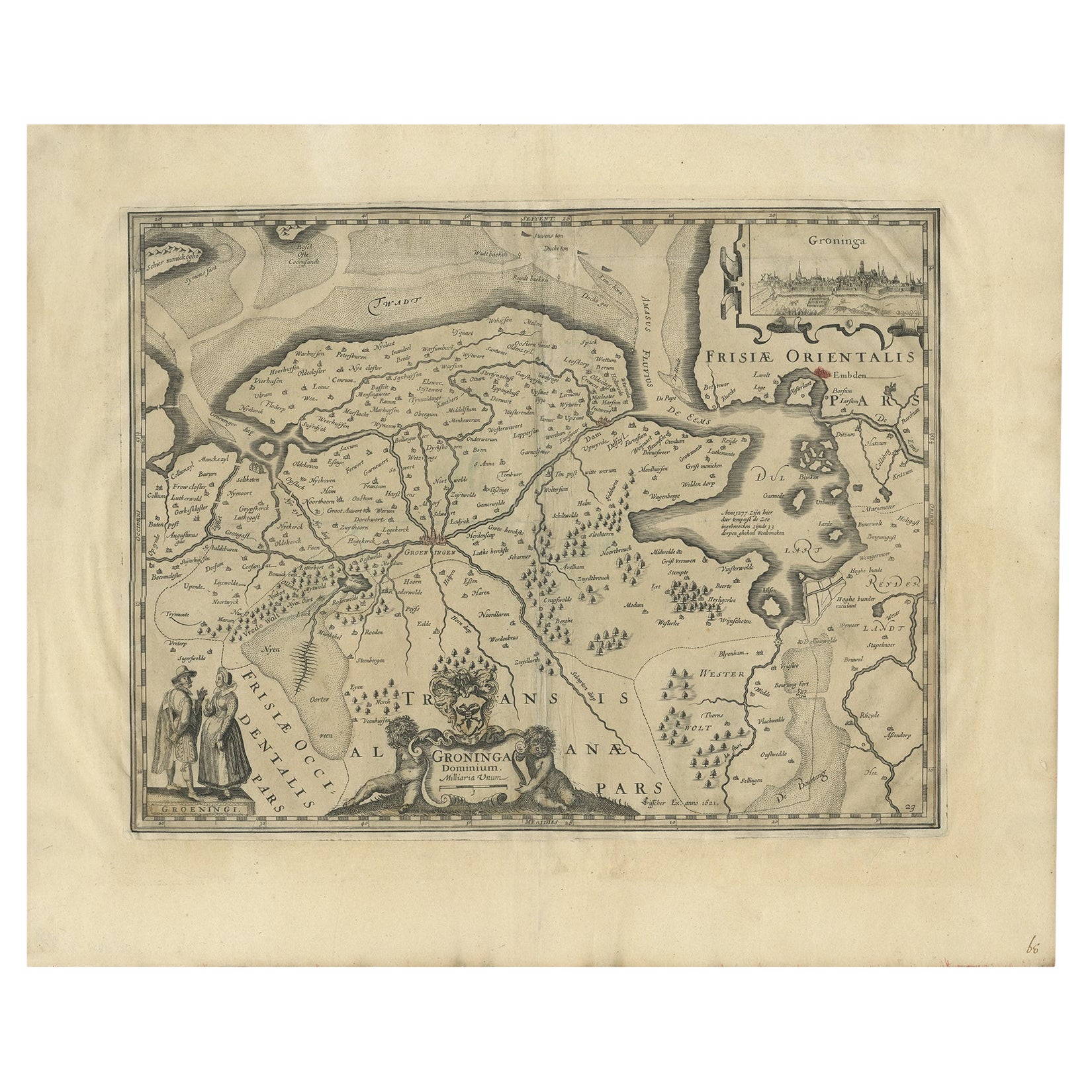
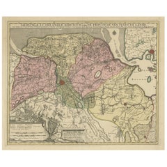
View AllAntique Map of the Province Groningen in The Netherlands, c.1680
Located in Langweer, NL
Antique map titled 'Groningae et Omlandiae Dominium vulgo de Provincie van Stadt en Lande'.
Old map of the province of Groningen, the Netherlands. This map originates from 'Germani...
Category
Antique 17th Century Maps
Materials
Paper
$456 Sale Price
20% Off
Antique Map of the Province of Groningen in the Netherlands, c.1700
Located in Langweer, NL
Antique map titled 'Groningae et Omlandiae Dominium vulgo de Provincie van Stadt en Lande'.
Old map of the province of Groningen, the Netherlands. This map originates from 'Atlas C...
Category
Antique 18th Century Maps
Materials
Paper
$791 Sale Price
20% Off
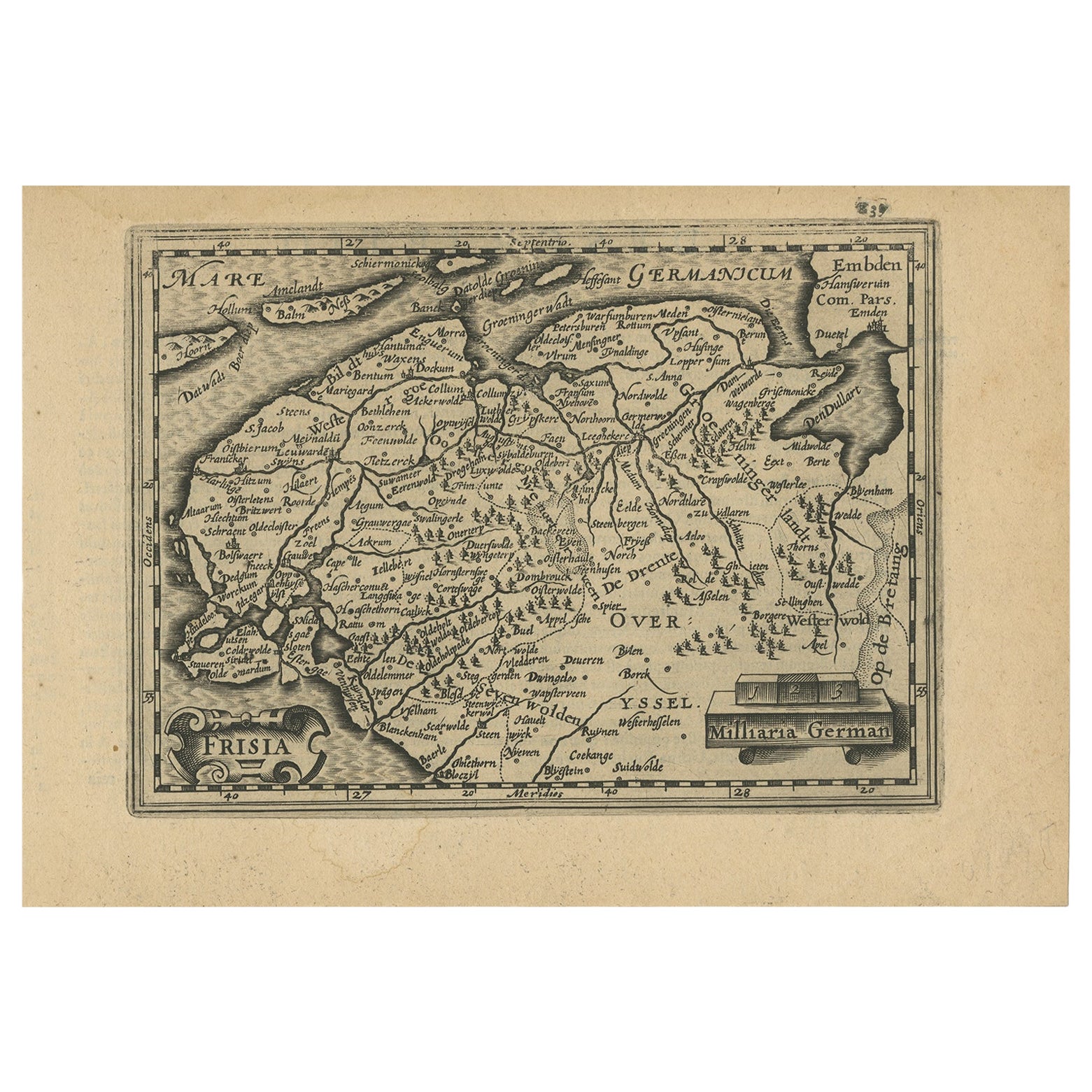
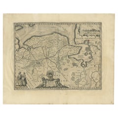
Antique Map of the Province of Groningen in the Netherlands, 1634
Located in Langweer, NL
Antique map titled 'Groninga Dominium'.
Old map of the province of Groningen, the Netherlands. In the upper right hand corner a general view of Groningen (taken from Guicciardini...
Category
Antique 17th Century Maps
Materials
Paper
$726 Sale Price
20% Off
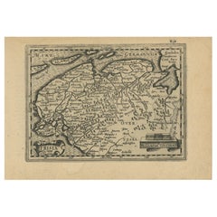
Antique Map of Friesland and Groningen in The Netherlands, 1616
Located in Langweer, NL
Antique map titled 'Frisia'. Small map of the province of Friesland, the Netherlands.
This map originates from 'Omnium Belgii, sive Inferioris Germaniae, regionum descriptio' by ...
Category
Antique 17th Century Maps
Materials
Paper
$335 Sale Price
20% Off
Beautiful Antique Map of the Province of Noord-Holland, the Netherlands, Ca.1730
Located in Langweer, NL
Antique map titled 'Kennemaria et Westfrisia vulgo et vernaculé Noord-Holland'.
Beautiful original antique map of the province of Noord-Holland, the Netherlands. Two large elaborat...
Category
Antique 1730s Maps
Materials
Paper
$1,350 Sale Price
20% Off
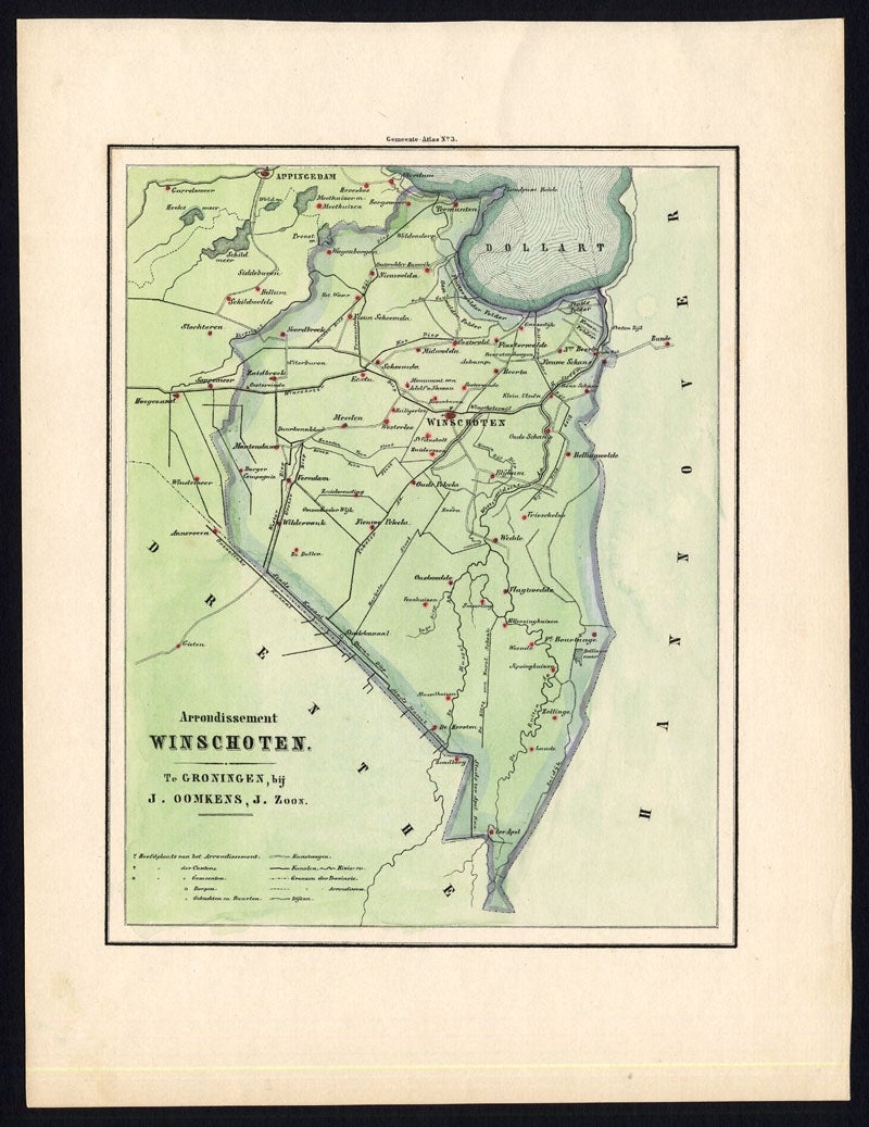
Antique Map of the Township of Marum in Groningen, The Netherlands, 1862
Located in Langweer, NL
Groningen: Gemeente Marum-Noordwijk-NuiS. These scarse detailed maps of Dutch Towns originate from the 'Gemeente atlas van de Provincie Groningen in 62 kaarten.' by C. Fehse. This at...
Category
Antique 19th Century Maps
Materials
Paper
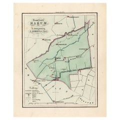
$167 Sale Price
20% Off
You May Also Like
Framed 1820s Hand Colored Map of the United States
Located in Stamford, CT
Framed 1820s hand colored map photos of North America and South America. As found framed in giltwood frame.
Category
Antique 1820s American Spanish Colonial Maps
Materials
Giltwood, Paper, Glass

Framed 1839 Hand Colored Map of the United States
Located in Stamford, CT
Framed hand colored map of the United States of America from 1839. Newly framed in a giltwood frame.
Category
Antique 1830s American American Classical Maps
Materials
Giltwood, Paper, Glass

Colored wall map of the WORLD
By Chambon
Located in ZWIJNDRECHT, NL
“Mappe Monde, contenant les Parties Connues du Globe Terrestre”
CHAMBON, Gobert-Denis (France, 17.. - 1781)
Paris, Longchamps et Janvier, 1754
Size H. 115 x W. 145 cm.
Gobert-Denis Chambon made copper engraving after the work of Guillaume De L’Isle, published in 1754 by Jean Janvier and S.G. Longschamps.
A huge wall map of the world in two hemispheres printed on two sheets, depicting the Eastern and Western hemispheres supported by two male figures, decorated at the bottom right and left with two celestial hemispheres (boreal and southern) and at the bottom in the middle with an armillary sphere, in addition.
This map is most notable for its depiction of the Sea of Japan labeled "Mer de Corée" and of "Mer de L'Ouest" or Sea of the West - a great sea, easily the size of the Mediterranean, to flow from the then-known Strait of Juan de Fuca...
Category
Antique Mid-18th Century French French Provincial Maps
Materials
Wood, Paper

1864 Map of North America, Antique Hand-Colored Map, by Adolphe Hippolyte Dufour
Located in Colorado Springs, CO
Offered is a map of North America entitled Amerique du Nord from 1864. This rare, separately published wall map was produced by Adolphe Hippolyte Dufour. This map includes vibrant an...
Category
Antique 1860s French Maps
Materials
Paper

17th Century Hand Colored Map of the Liege Region in Belgium by Visscher
By Nicolaes Visscher II
Located in Alamo, CA
An original 17th century map entitled "Leodiensis Episcopatus in omnes Subjacentes Provincias distincté divisusVisscher, Leodiensis Episcopatus" by Nicolaes Visscher II, published in Amsterdam in 1688. The map is centered on Liege, Belgium, includes the area between Antwerp, Turnhout, Roermond, Cologne, Trier and Dinant.
This attractive map is presented in a cream-colored mat measuring 30" wide x 27.5" high. There is a central fold, as issued. There is minimal spotting in the upper margin and a tiny spot in the right lower margin, which are under the mat. The map is otherwise in excellent condition.
The Visscher family were one of the great cartographic families of the 17th century. Begun by Claes Jansz Visscher...
Category
Antique Late 17th Century Dutch Maps
Materials
Paper

Staffordshire 1645 Hand Colored Antique Print Staffordiensis Comitatvs Map
Located in West Sussex, Pulborough
We are delighted to offer for sale this lovely antique Atlas page map of Staffordshire printed in 1645 Amsterdam Staffordiensis Comitatvs Vulgo
This o...
Category
Antique Early 1800s English Georgian Maps
Materials
Paper

$497 Sale Price
20% Off
Recently Viewed
View AllMore Ways To Browse
Chinese Gold Thread Tapestries
Chinese Gold Thread Tapestry
Chinese Leopard
Chinese Mountain Jar
Chinese Oval Coffee Table
Chinese Porcelain Rice Bowls
Chinese Porcelain Tobacco Leaf
Chinese Walking Stick
Chinese Wood Stand With Marble Top
Chinoiserie Egg
Chinoiserie Wall Shelf
Chippendale Dressing Table
Christian Dior Porcelain
Christian Durupt
Christofle Teapot
Chrome Glass Coffee Table Flat Bar
Church Organ
Church Pulpit