Items Similar to Facsimile DesBarres (1776) Chart of Nantucket Island, circa 1966
Want more images or videos?
Request additional images or videos from the seller
1 of 10
Facsimile DesBarres (1776) Chart of Nantucket Island, circa 1966
$2,800
£2,135.43
€2,460.57
CA$3,999.73
A$4,397.25
CHF 2,273
MX$52,615.85
NOK 28,696.17
SEK 26,903.46
DKK 18,376.93
About the Item
Facsimile DesBarres (1776) Chart of Nantucket Island and the Eastern Half of Martha's Vineyard, published by the Massachusetts Historical Society in association with Haley & Steele, Newbury Street, Boston, circa 1966, depicting the islands’ natural and human topography including roads, residences and numerous landmarks; oceanic details include soundings, shoals, rocks and other hazards, particularly in the Sound, and there are sailing directions for entering Nantucket Harbor and navigating Muskeget Shoals and other hazardous waters.
This is a contemporary museum quality hand colored chart re-struck from the original copperplate engraving done by Joseph F.W. DesBarres (British: 1722 - 1824) in 1776, issued on its own and as an inclusion in his "Atlantic Neptune" compendium of charts rushed into print in 1777 for use by the British navy during the opening months of the American Revolution. He repeatedly improved and revised the charts up to 1781 (and possibly later). This was the first published map of Nantucket and Martha’s Vineyard, and the remarkable accuracy and detail were not surpassed until the U.S. Coast Survey charted the region in the mid-19th century.
This chart was purchased directly from the Haley & Steele Gallery in 2002 and remains in excellent condition, mounted with conservation matting in a contemporary ebonized frame with gilt filet.
Measures: 31-3/4 in H x 44-1/2 in W
Framed: 40-3/4 in H x 52-3/8 in W
- Dimensions:Height: 40.75 in (103.51 cm)Width: 52.38 in (133.05 cm)Depth: 0.75 in (1.91 cm)
- Style:Other (In the Style Of)
- Materials and Techniques:
- Place of Origin:
- Period:
- Date of Manufacture:Circa 1966
- Condition:Wear consistent with age and use.
- Seller Location:Nantucket, MA
- Reference Number:Seller: AD - CE-2 WHEY1stDibs: LU903947011752
About the Seller
5.0
Gold Seller
Premium sellers maintaining a 4.3+ rating and 24-hour response times
1stDibs seller since 2010
276 sales on 1stDibs
Typical response time: 1 hour
- ShippingRetrieving quote...Shipping from: Nantucket, MA
- Return Policy
Authenticity Guarantee
In the unlikely event there’s an issue with an item’s authenticity, contact us within 1 year for a full refund. DetailsMoney-Back Guarantee
If your item is not as described, is damaged in transit, or does not arrive, contact us within 7 days for a full refund. Details24-Hour Cancellation
You have a 24-hour grace period in which to reconsider your purchase, with no questions asked.Vetted Professional Sellers
Our world-class sellers must adhere to strict standards for service and quality, maintaining the integrity of our listings.Price-Match Guarantee
If you find that a seller listed the same item for a lower price elsewhere, we’ll match it.Trusted Global Delivery
Our best-in-class carrier network provides specialized shipping options worldwide, including custom delivery.More From This Seller
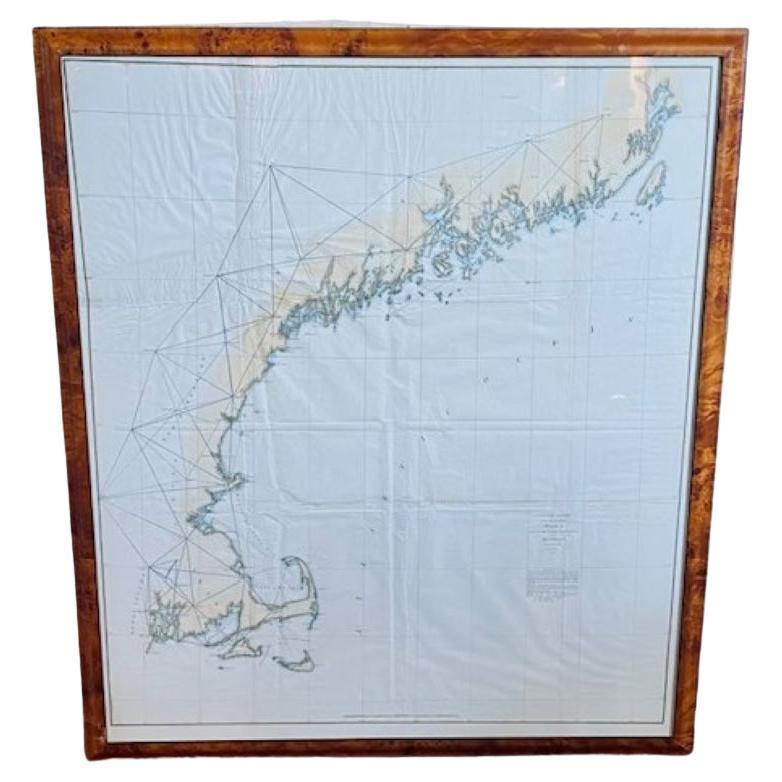
View All19th Century Chart of New England Coast, 1847
By U.S. Government
Located in Nantucket, MA
19th Century Chart of New England Coast: the U.S. Coast Survey Sketch A - Section 1, a triangulation chart showing the progress of the survey and details along the New England coas...
Category
Antique 1840s American Other Maps
Materials
Paper

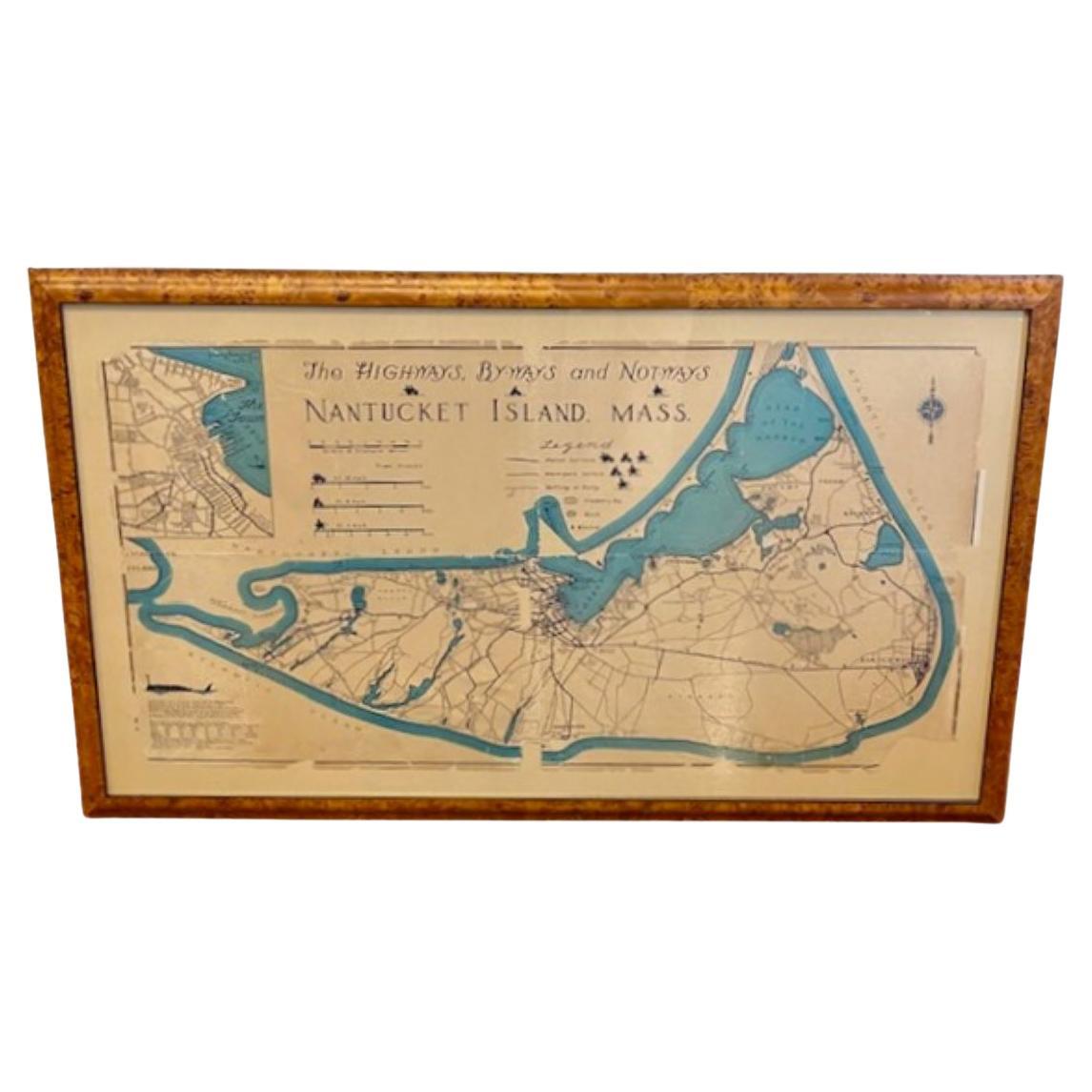
Nantucket High-Ways, By-Ways and Not-Ways Decorative Map by Tony Sarg, ca 1930
By Tony Sarg
Located in Nantucket, MA
Vintage Nantucket High-Ways, By-Ways and Not-Ways Decorative Map by Tony Sarg, (Nantucket: 1880 - 1942) circa 1930, a decorative tourist map of Nantucket Island with details of roadw...
Category
Vintage 1930s American Other Maps
Materials
Paper

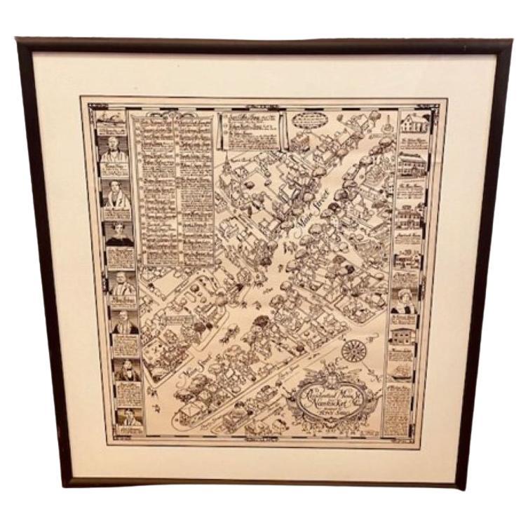
Tony Sarg Map of Nantucket Town, 1937
By Tony Sarg
Located in Nantucket, MA
Tony Sarg Map of Residential Main Street, Nantucket, 1937, a black and white printed map of our historic downtown area, with images of each building, street names and whimsical figur...
Category
Vintage 1930s American Other Maps
Materials
Paper

18th Century Hand Colored Map of The State of Massachusetts, 1796
Located in Nantucket, MA
18th Century Hand Colored Map of "The State of Massachusetts from the best information," 1796, by cartographer and illustrator John Reid published in his "American Atlas," a period e...
Category
Antique 1790s American American Colonial Maps
Materials
Paper

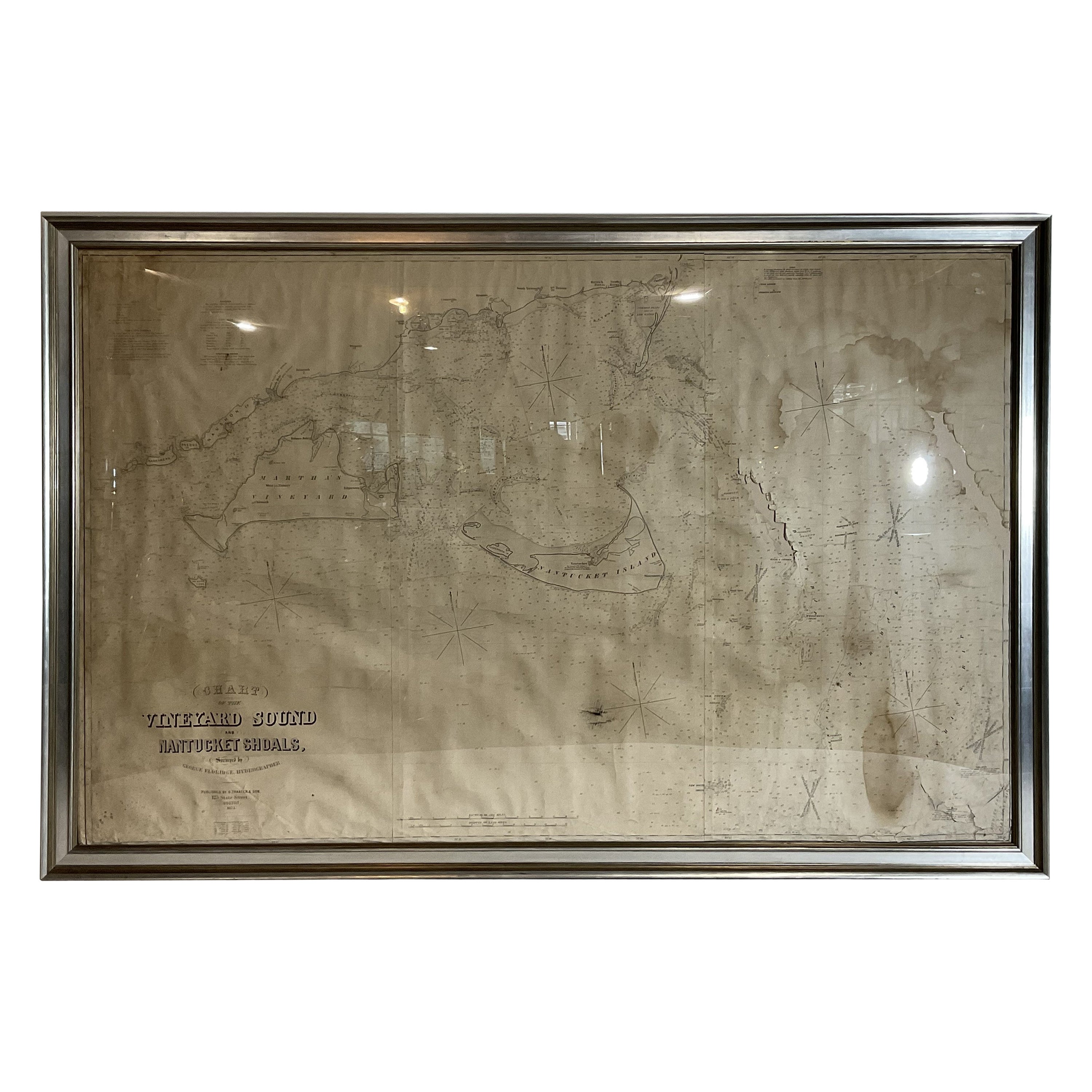
Large U.S. Coast and Geodetic Survey Chart A of the Atlantic Coast, 1877
Located in Nantucket, MA
Large U.S. Coast and Geodetic Survey Chart A of the Atlantic Coast, 1877, re-issued in February 1881, a printed paper laid down on linen navigational chart of the U.S. Atlantic coast...
Category
Antique 1880s American Other Maps
Materials
Linen

Nantucket Watercolor of Old North Wharf, by Doris and Richard Beer, circa 1940
Located in Nantucket, MA
Vintage Nantucket Watercolor of Old North Wharf, by Doris and Richard Beer, circa 1940, a watercolor on paper view of shell lane down center of ol...
Category
Vintage 1940s American Folk Art Paintings
Materials
Paper

You May Also Like
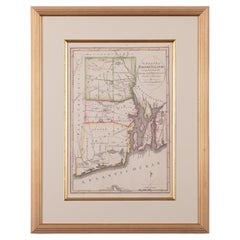
Maps of Nantucket Sound and Harbor Provenance: The Susie Hilfiger Collection
Located in Bristol, CT
Map Sz: 22 1/2"H x 17"W
Frame Sz: 26 1/2"H x 20 3/4"W
*w/ age toning/ slight creasing/ waving to mounted maps*
Provenance: The Susie Hilfiger Collection
From "Point of View", the...
Category
20th Century Drawings and Watercolor Paintings
Materials
Paper
1873 Martha's Vineyard and Nantucket Chart
Located in Norwell, MA
Original chart of Nantucket and Martha's Vineyard by George Eldridge, Cartographer, 125 State Street, Boston. Dated 1873. Mounted to canvas. Also showing the coast of Cape Cod includ...
Category
Antique 1870s North American Maps
Materials
Paper

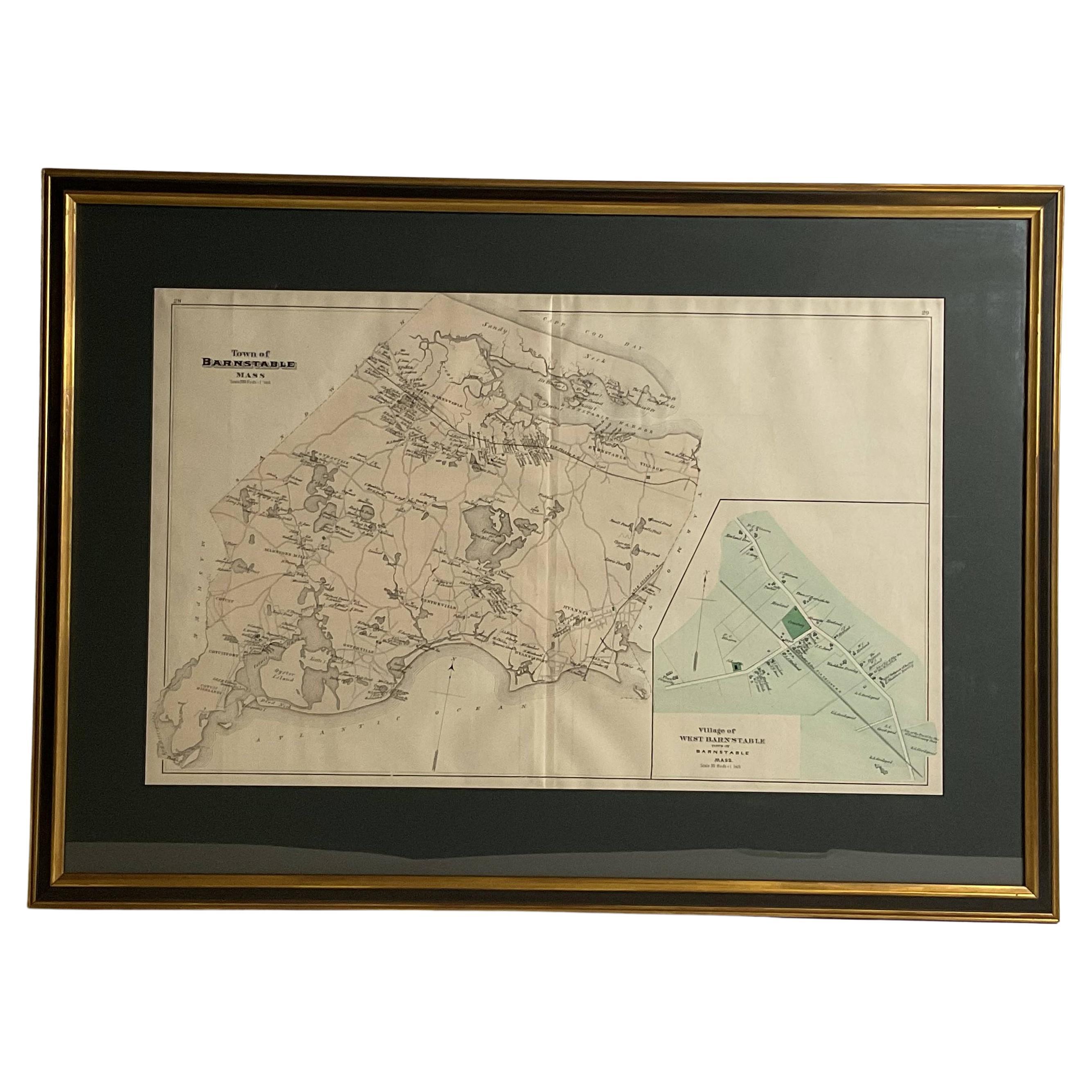
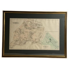
Oyster Harbors Osterville Centerville Cotuit Sandy Neck Map
Located in Norwell, MA
Barnstable country map from the nineteenth century. The map shows the Atlantic coast from Cotuit Highlands past Hyannisport, Hyannis, Sandy Neck, Marstons, Mills, etc., This map is a...
Category
Antique 1890s North American Prints
Materials
Paper
The State of Rhode Island Map - Caleb Harris & Harding Harris, 1818
Located in Savannah, GA
Mathew Carey
(American/Philadelphia, 1760-1839)
The State of Rhode Island compiled from the surveys and observations of Caleb Harris by Harding Harris. Engraving with hand-coloring...
Category
Antique 1810s American Other Prints
Materials
Glass, Wood, Paper
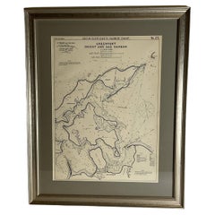
Sag Harbor Nautical Chart
Located in Norwell, MA
Marine chart of Greenport, Orient, and Sag Harbor New York published by George Eldridge in 1901. Details include the areas of Greenport, Orient, Shelter ...
Category
Antique Early 1900s Prints
Materials
Paper
Mariners charts of Massachusett Long Island by George Eldridge 1901
Located in Norwell, MA
Nautical Chart showing the harbor and local waters of the Little Neck Bay, Manhasset and Hempstead Harbors. The chart displays depths, buoys, lighthouses, etc., Shown is Manhasset Ne...
Category
Antique Early 1900s North American Prints
Materials
Paper
