Items Similar to A General View of Jerusalem in the Early Part of the 18th Century" (circa 1752)

Want more images or videos?
Request additional images or videos from the seller
1 of 8
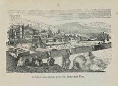
A General View of Jerusalem in the Early Part of the 18th Century" (circa 1752)
$419.54
$524.4220% Off
£310.67
£388.3320% Off
€352
€44020% Off
CA$576.93
CA$721.1620% Off
A$641.69
A$802.1220% Off
CHF 335.85
CHF 419.8120% Off
MX$7,826.53
MX$9,783.1620% Off
NOK 4,220.05
NOK 5,275.0620% Off
SEK 3,969.50
SEK 4,961.8820% Off
DKK 2,679.88
DKK 3,349.8620% Off
About the Item
The print is signed by the artist "S. Mynde sc." in the lower right corner. This suggests that the maker of the print is Samuel Mynde, a known engraver from the 18th century. His works often included engravings for books, maps, and prints, contributing to the dissemination of geographical and historical knowledge during that time. The signature "sc" stands for "sculpsit," a Latin term meaning "engraved by."
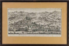
This evocative print, titled **"A General View of Jerusalem in the Early Part of the 18th Century" (circa 1752)**, offers a captivating glimpse into the rich history and complex layering of the ancient city of Jerusalem during a pivotal period in its storied past. The image, produced around 1752, presents a panoramic scene of the city as it appeared before the significant transformations that were to take place in the following centuries.
Nestled amidst the undulating hills of the Judean Mountains, Jerusalem's iconic silhouette is dominated by the golden-hued Dome of the Rock, a revered Islamic shrine, and the adjacent Al-Aqsa Mosque, both of which are surrounded by the sprawling Temple Mount complex. The Old City walls, encircling the historic core, are visible in the foreground, their fortified gates providing entry to the various quarters – Christian, Armenian, Jewish, and Muslim – that housed the diverse communities living within the city's confines.
The print also reveals the bustling activity of the city's markets and streets, with merchants and traders haggling over goods, and the daily life of the residents unfolding amidst the vibrant urban landscape. The verdant gardens and orchards that once dotted the city's outskirts are also evident, adding to the picture of a thriving, cosmopolitan center.
The early 18th century was a time of relative peace and prosperity for Jerusalem, which served as an important crossroads for trade and pilgrimage. However, this tranquility would soon be disrupted by the political and religious tensions that would shape the city's destiny for centuries to come. This print serves as a poignant reminder of the enduring allure and complex history of Jerusalem, a city that continues to captivate and inspire generations.
More research to be done on the source.
- Dimensions:Height: 8.47 in (21.5 cm)Width: 13.98 in (35.5 cm)Depth: 0.01 in (0.2 mm)
- Materials and Techniques:Paper,Engraved
- Period:1750-1759
- Date of Manufacture:1752
- Condition:Condition: good, given age. General age-related toning and/or occasional minor defects from handling. One small corner (outside the image) attached to a paper backing. Please study scan carefully.
- Seller Location:Langweer, NL
- Reference Number:Seller: BG-13449-11stDibs: LU3054340396722
About the Seller
5.0
Recognized Seller
These prestigious sellers are industry leaders and represent the highest echelon for item quality and design.
Platinum Seller
Premium sellers with a 4.7+ rating and 24-hour response times
Established in 2009
1stDibs seller since 2017
2,599 sales on 1stDibs
Typical response time: <1 hour
- ShippingRetrieving quote...Shipping from: Langweer, Netherlands
- Return Policy
Authenticity Guarantee
In the unlikely event there’s an issue with an item’s authenticity, contact us within 1 year for a full refund. DetailsMoney-Back Guarantee
If your item is not as described, is damaged in transit, or does not arrive, contact us within 7 days for a full refund. Details24-Hour Cancellation
You have a 24-hour grace period in which to reconsider your purchase, with no questions asked.Vetted Professional Sellers
Our world-class sellers must adhere to strict standards for service and quality, maintaining the integrity of our listings.Price-Match Guarantee
If you find that a seller listed the same item for a lower price elsewhere, we’ll match it.Trusted Global Delivery
Our best-in-class carrier network provides specialized shipping options worldwide, including custom delivery.More From This Seller
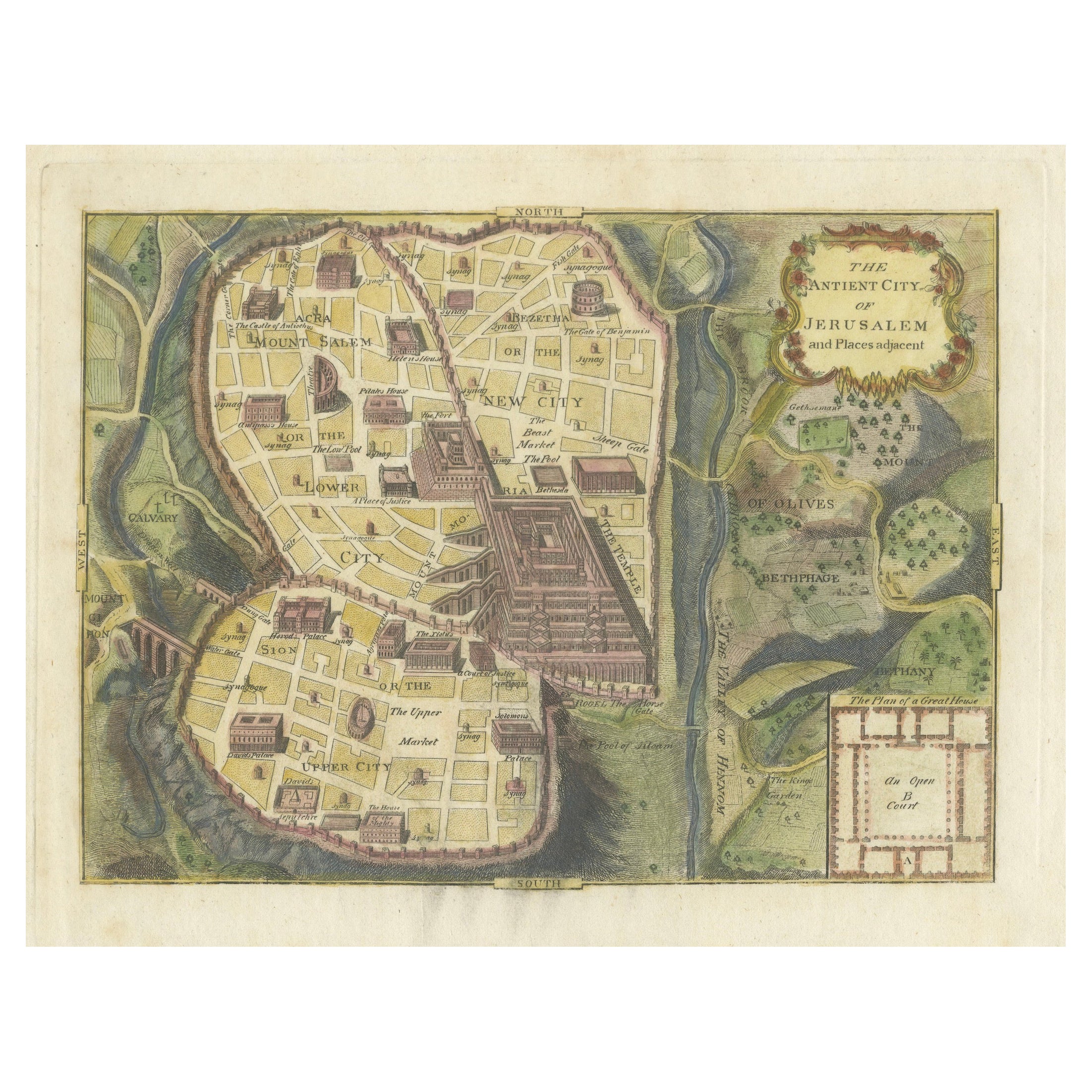
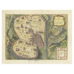
View AllThe Antient City of Jerusalem and Places Adjacent, Hand-Colored Map, 1699
Located in Langweer, NL
Title: "1699 Hand-Colored Bird's-Eye Plan of Jerusalem with Ancient and Biblical Landmarks"
This beautifully hand-colored, imaginary bird's-eye plan of Jerusalem, published in 1699,...
Category
Antique 1690s Maps
Materials
Paper
$247 Sale Price
20% Off
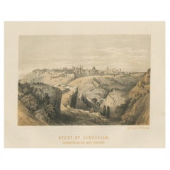
19th-Century Chromolithograph of Jerusalem – View from the Road to Bethany, 1862
Located in Langweer, NL
Title: 19th-Century Chromolithograph of Jerusalem – View from the Road to Bethany After David Roberts
Description:
This remarkable 19th-century chromolithograph presents a panor...
Category
Antique 1860s Prints
Materials
Paper
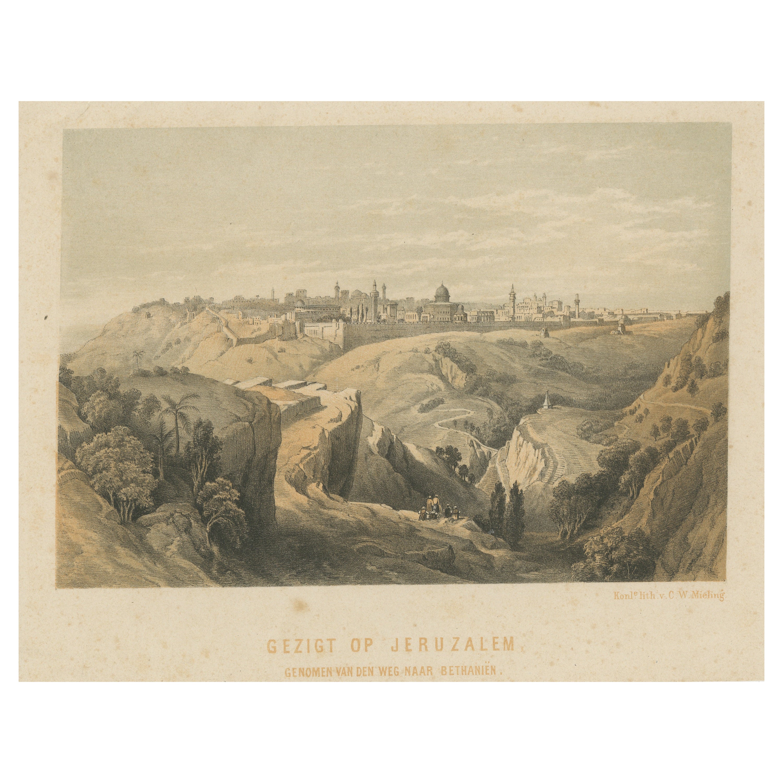
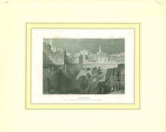
Antique Lithograph of Jerusalem from the Road leading to Bethany
Located in Langweer, NL
Antique print titled 'Gezigt op Jeruzalem genomen van den weg naar Bethaniën'. Lithograph of Jerusalem from the Road leading to Bethany. Published by C.W. Mieling, circa 1880.
Category
Antique Late 19th Century Prints
Materials
Paper
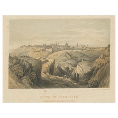
$171 Sale Price
20% Off
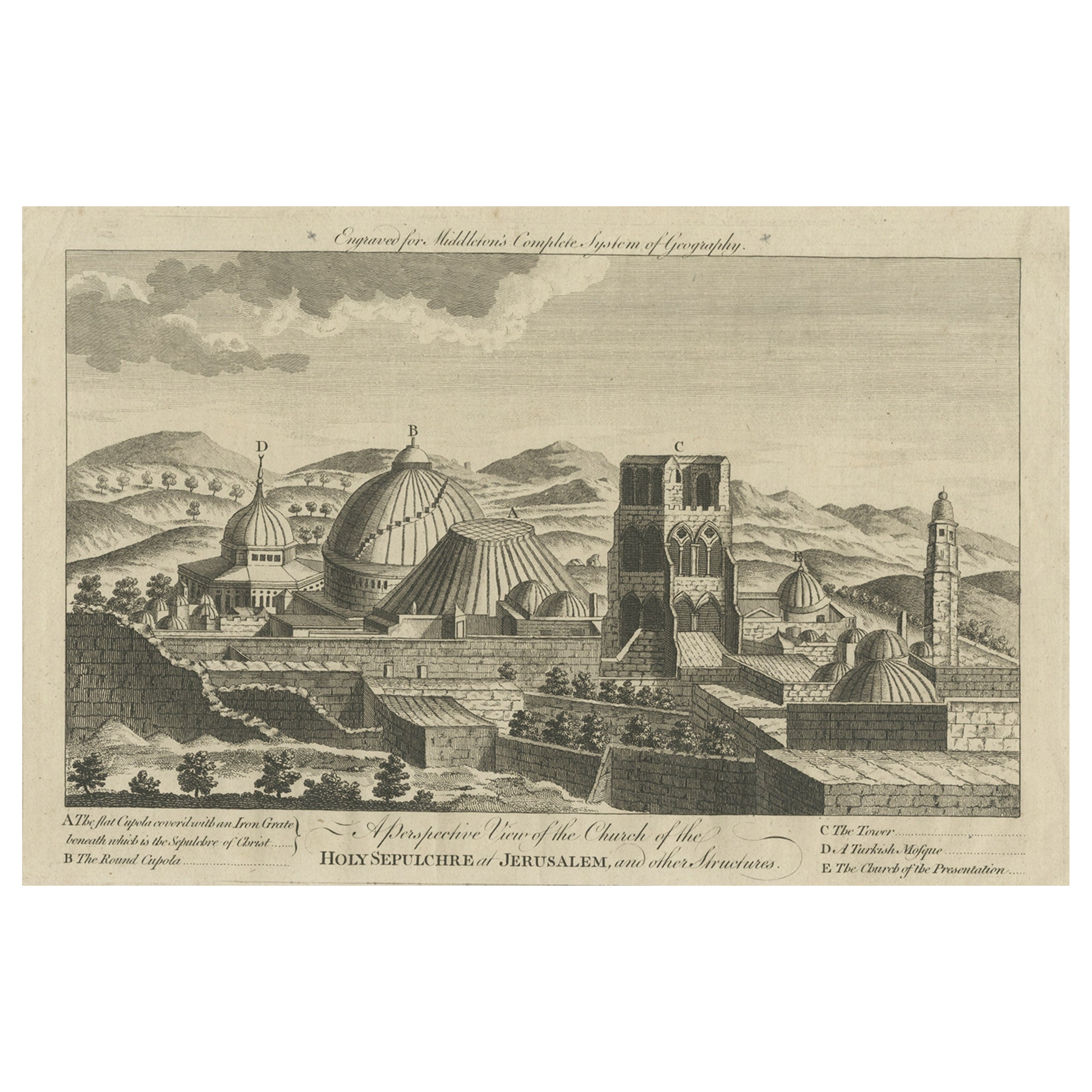
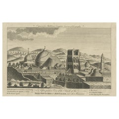
Antique View of the Holy Sepulchre Church in Jerusalem, Ca.1778
Located in Langweer, NL
Description: Antique print titled 'A perspective View of the Church of the Holy Sepulchre at Jerusalem and other Structures'.
A view of the Holy Sep...
Category
Antique 1770s Prints
Materials
Paper
$324 Sale Price
20% Off
Antique Bible Plan of Ancient Jerusalem, 1743
Located in Langweer, NL
This plan originates from ‘Biblia Sacra, dat is, de H. Schriftuer van het Oude, en het Nieuwe Testament, naer de laetste Roomsche keure der gemeine Latijnsche overzettinge, in nederd...
Category
Antique Mid-18th Century Maps
Materials
Paper

$819 Sale Price
37% Off
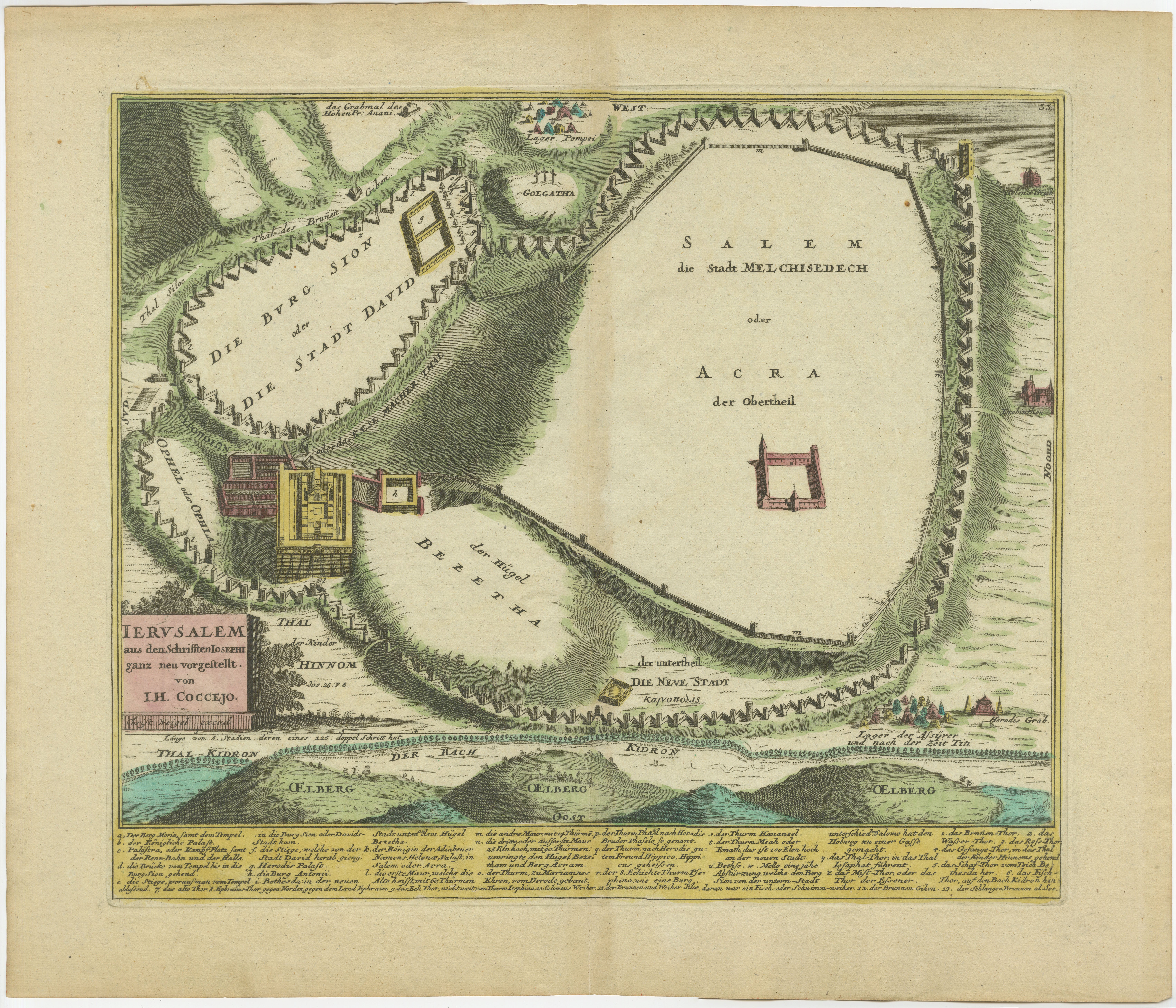
1720 Weigel Engraving of Jerusalem: A Biblical View from Josephus' Perspective
Located in Langweer, NL
1720 Weigel Map of Jerusalem Based on Josephus' Writings
This intricate 1720 bird's-eye view map of ancient Jerusalem by I.H. Coccejo, engraved by Christoph Weigel, offers a fasc...
Category
Antique 1720s Maps
Materials
Paper

You May Also Like
Ancient View of Jerusalem - Original Lithograph - Half of the 19th Century
Located in Roma, IT
Ancient View of Jerusalem is an original modern artwork realized in the first half of the 19th Century.
Original B/W Lithograph on Ivory Paper.
Inscripted on the lower margin in ...
Category
Mid-19th Century Modern Landscape Prints
Materials
Lithograph
18th Century French Map and City View of Joppe/Jaffa (Tel Aviv) by Sanson
By Nicholas Sanson d'Abbeville
Located in Alamo, CA
An original antique engraving entitled "Joppe; in ’t Hebreeusch by ouds Japho; hedendaags Japha, of Jaffa; volgens d’aftekening gedaan 1668", by Nicholas Sanson d'Abbeville (1600 - 1667). This is a view of the city of Joppe (in Hebrew Japho), now called Japha or Jaffa, the harbor portion of modern day Tel Aviv, Israel as it appeared in 1668 . It depicts a very busy harbor with numerous boats. A large ship on the left appears to be firing its canons and a small ship on the right appears to be sitting very low in the water, either heavily loaded with cargo or sinking. The town is seen on the far shore with a fortress on a hill across in the background. The map is printed from the original Sanson copperplate and was published in 1709 by his descendants.
The map is presented in an ornate brown wood frame embellished by gold-colored leaves and gold inner trim with a double mat; the outer mat is cream-colored and the inner mat is black. There is a central vertical fold, as issued. There are two small spots in the lower margin and one in the upper margin, as well as two tiny spots adjacent to the central fold. 1717 is written below the date 1668 in the inscription. The map is otherwise in very good condition.
Another map of the "Holy Land" (by Claes Visscher in 1663), with an identical style frame and mat is available. This pair of maps would make a wonderful display grouping. Please see Reference #LU117324709892.
Artist: Nicholas Sanson d'Abbeville (1600 - 1667) and his descendents were important French cartographer's active through the 17th century. Sanson started his career as a historian and initially utilized cartography to illustrate his historical treatises. His maps came to the attention of Cardinal Richelieu and then King Louis XIII of France, who became a supporter and sponsor. He subsequently appointed Sanson 'Geographe Ordinaire du Roi' the official map maker to the king. Sanson not only created maps for the king, but advised him on geographical issues and curated his map collection...
Category
Early 1700s Prints and Multiples
Materials
Engraving

Ancient View of Lyon - Etching - 1748
Located in Roma, IT
Etching on paper realized in 1748.
Very good condition except for some minor foxing.
Includes a wooden frame cm. 27.5x41.5
Category
1740s Modern Figurative Prints
Materials
Etching
Jerusalem
By Percy John Delf Smith, R.D.I.
Located in Storrs, CT
1931. Pencil, ink and watercolor. 9 1/4 x 15 (framed 18 1/2 x 24 1/2). Signed and dated in pencil. Housed in a silk mat and an elegant carved gold leaf frame.
Twelve of the artist'...
Category
1930s Modern Landscape Prints
Materials
Ink, India Ink, Watercolor, Pencil
$1,350 Sale Price
32% Off
View of Jerusalem taken from the Mount of Olives - Lithograph - 1862
Located in Roma, IT
View of Jerusalem taken from the Mount of Olives is a lithograph realized in 1864.
Good conditions.
The artwork belongs to the Suite Uses and customs of all the peoples of the uni...
Category
1840s Modern Figurative Prints
Materials
Lithograph
Original Antique Print of Jerusalem After J.M.W Turner. Dated 1834
Located in St Annes, Lancashire
Wonderful image of Jerusalem
Fine steel engraving after J.M.W Turner
Published by John Murray & Son, London. Dated 1836
Unframed.
Category
Antique 1830s English Moorish Prints
Materials
Paper
More Ways To Browse
18th Century Icon
Wall Shrine
Dome Of The Rock
Silver Over Copper
Vintage Barware Glasses
Coffee Table Black Italian Modern
Christofle America
Iranian Silk Rug Carpet
Poul Moller
Tables With Inlaid Wood
World War Table
Antonio Jacobsen
Ariston Chairs
Coffee Tables Europe
Marble Top Dining Tables
Nordiska Argentina
Pink And Black Rug
Black Wooden Chair