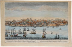
Items Similar to Konstantinopel – Panoramic View of Istanbul by François Halma, 1705


Video Loading
Want more images or videos?
Request additional images or videos from the seller
1 of 11
Konstantinopel – Panoramic View of Istanbul by François Halma, 1705
$794.21
£587.99
€660
CA$1,099.64
A$1,200.54
CHF 629.39
MX$14,581.03
NOK 7,860.11
SEK 7,422.04
DKK 5,024.72
About the Item
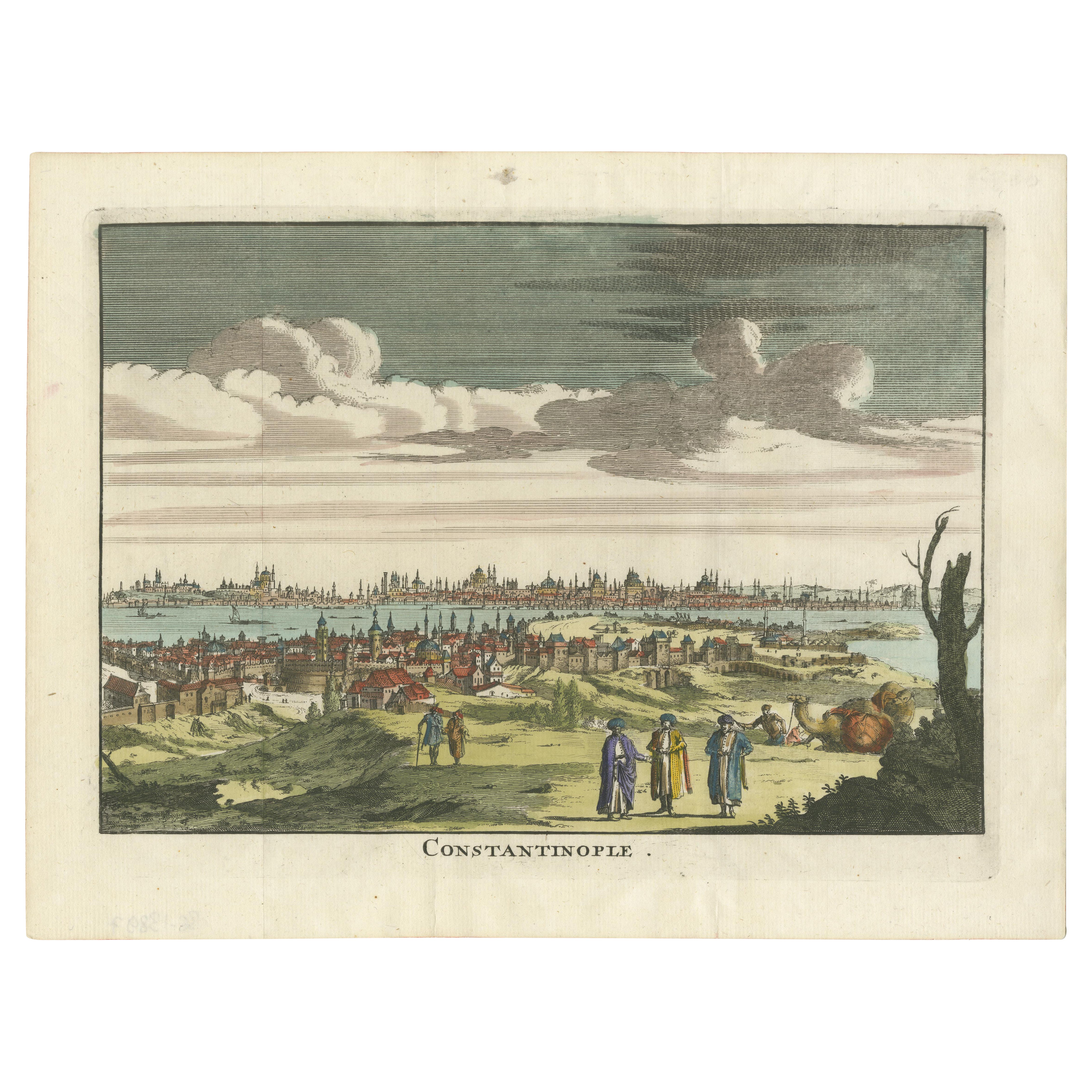
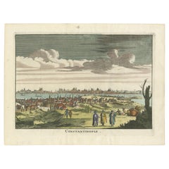
Konstantinopel – Panoramic View of Istanbul by François Halma, 1705
This engaging hand-colored engraving of “Konstantinopel” offers a sweeping panoramic view of 18th-century Istanbul, published in 1705 by François Halma in the Dutch geographical compendium Algemeene Weereld-Beschryving.... The print shows the bustling metropolis of Constantinople straddling the Bosphorus, with the skyline of domes and minarets stretching dramatically across the background.
In the foreground, a vivid pastoral scene unfolds. Colorfully dressed townspeople, including three prominent Ottoman figures in ornate robes and turbans, are depicted conversing on a grassy hill. A camel rests beside a tree to the right, evoking the exotic allure that fascinated European audiences of the time. Additional travelers and townspeople dot the surrounding landscape, while the waters of the Golden Horn and Bosphorus are animated with Ottoman sailing vessels.
The image is not only decorative but also informative, offering a stylized yet recognizable topographic portrait of the city as seen from Galata across the water. It reflects the European view of the Ottoman capital at a time when it stood as a powerful, cosmopolitan hub connecting East and West. The perspective, bold lines, and vibrant hand coloring suggest it may have been intended for optical viewing devices such as zograscopes.
This print was part of the Dutch edition of Nouvelle Méthode Pour Apprendre Facilement la Géographie Universelle by A. Phérotée de la Croix, first published in 1690. François Halma, a respected Dutch printer and bookseller, issued this version in 1705, expanding its reach to a northern European audience.
Condition: Very good condition. Strong original hand-coloring. Slight age-related toning and light foxing primarily in the margins. Vertical centerfold as issued. No major tears or repairs.
Framing tips: Best presented in a dark wood or black frame with a light ivory or cream mat to highlight the vibrancy of the costumes and landscape while preserving the antique character of the paper.
Technique: Copperplate engraving with original hand-coloring
Maker: François Halma, Amsterdam
Publication: Algemeene Weereld-Beschryving..., 1705
- Dimensions:Height: 8.67 in (22 cm)Width: 12.8 in (32.5 cm)Depth: 0.01 in (0.2 mm)
- Materials and Techniques:Paper,Engraved
- Place of Origin:
- Period:
- Date of Manufacture:circa 1705
- Condition:Condition: Very good condition. Strong original hand-coloring. Slight age-related toning and light foxing primarily in the margins. Vertical centerfold as issued. No major tears or repairs.
- Seller Location:Langweer, NL
- Reference Number:Seller: BG-138961stDibs: LU3054346176502
About the Seller
5.0
Recognized Seller
These prestigious sellers are industry leaders and represent the highest echelon for item quality and design.
Platinum Seller
Premium sellers with a 4.7+ rating and 24-hour response times
Established in 2009
1stDibs seller since 2017
2,641 sales on 1stDibs
Typical response time: <1 hour
- ShippingRetrieving quote...Shipping from: Langweer, Netherlands
- Return Policy
Authenticity Guarantee
In the unlikely event there’s an issue with an item’s authenticity, contact us within 1 year for a full refund. DetailsMoney-Back Guarantee
If your item is not as described, is damaged in transit, or does not arrive, contact us within 7 days for a full refund. Details24-Hour Cancellation
You have a 24-hour grace period in which to reconsider your purchase, with no questions asked.Vetted Professional Sellers
Our world-class sellers must adhere to strict standards for service and quality, maintaining the integrity of our listings.Price-Match Guarantee
If you find that a seller listed the same item for a lower price elsewhere, we’ll match it.Trusted Global Delivery
Our best-in-class carrier network provides specialized shipping options worldwide, including custom delivery.More From This Seller
View AllConstantinople (Istanbul) – City View by Werner and Gläser, Augsburg ca.1730
Located in Langweer, NL
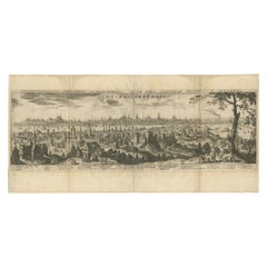
Constantinople (Istanbul) – Panoramic City View by Werner and Gläser, Augsburg c.1730
This striking hand-colored copper engraving offers a grand panoramic view of Constantinople (mo...
Category
Antique Early 18th Century German Maps
Materials
Paper

Constantinople – Panoramic Hand-Colored Engraving, Augsburg, circa 1720
Located in Langweer, NL
Constantinople – Panoramic Hand-Colored Engraving, Augsburg, circa 1720
This panoramic hand-colored engraving presents a sweeping bird’s-eye view of Constantinople (modern-day Istan...
Category
Antique Early 18th Century German Maps
Materials
Paper
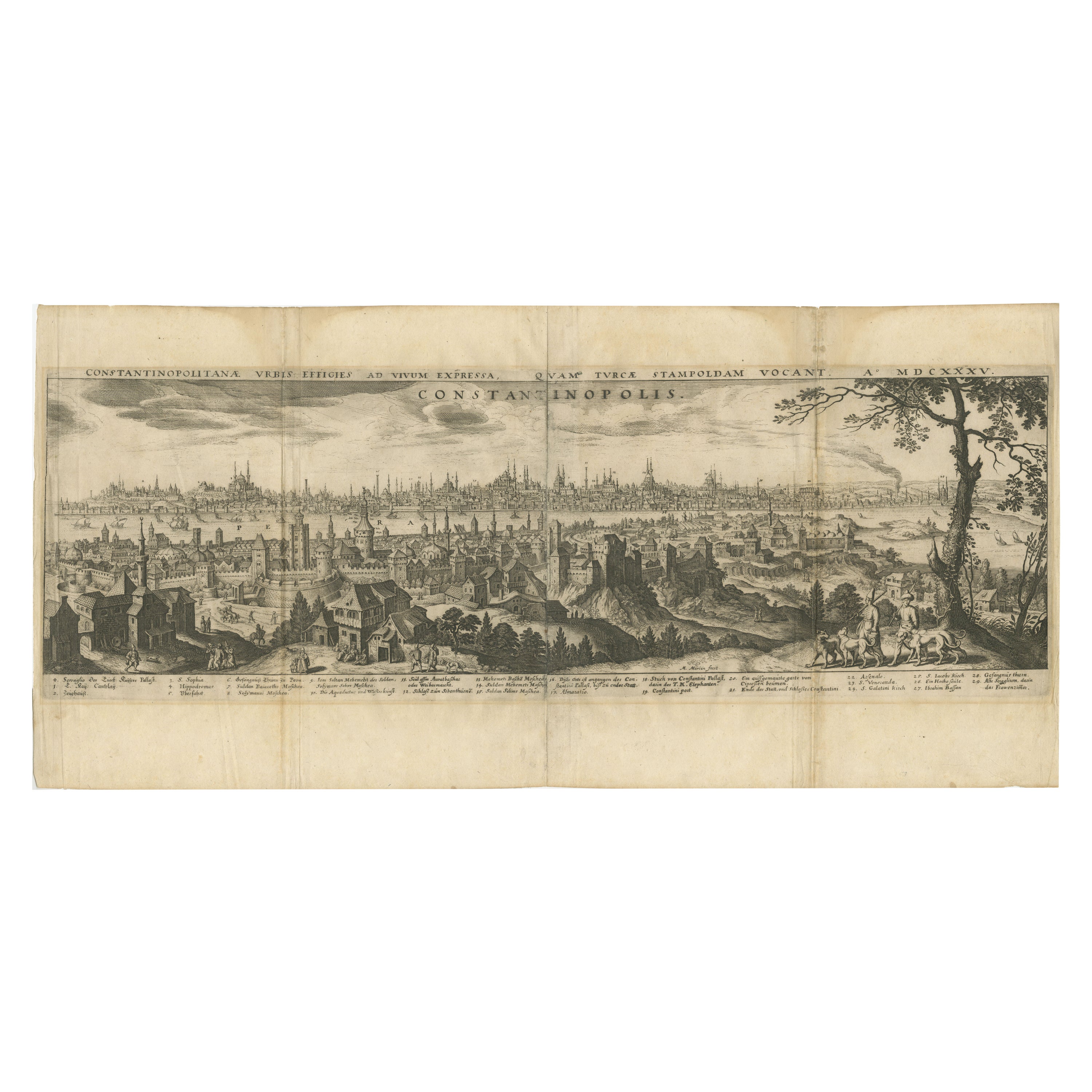
Constantinople – Panoramic Engraving by Matthäus Merian the Elder, 1635
Located in Langweer, NL
Constantinople – Panoramic Engraving by Matthäus Merian the Elder, Frankfurt, 1635
This finely detailed copperplate engraving presents a sweeping bird’s-eye view of Constantinople (...
Category
Antique Early 17th Century German Maps
Materials
Paper
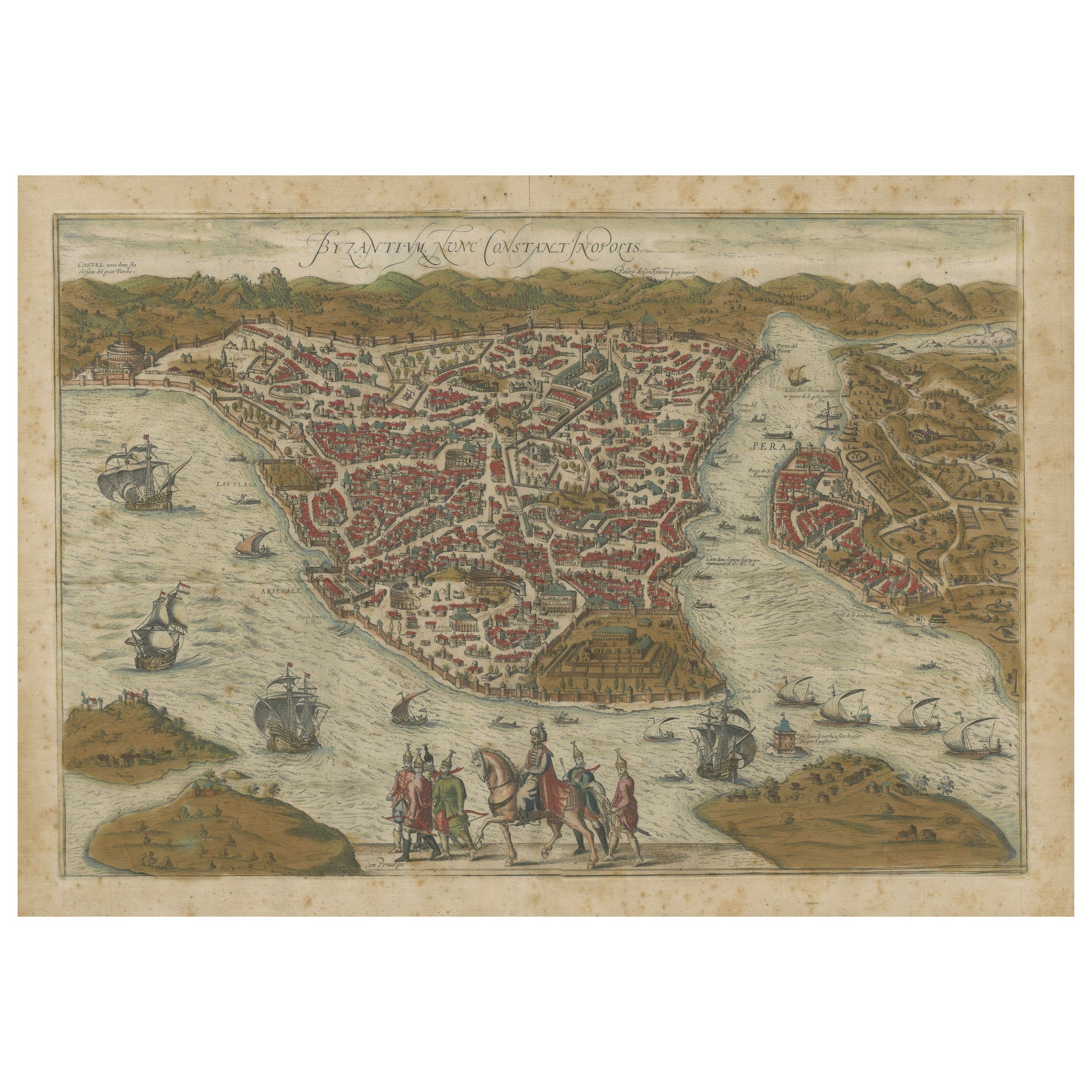
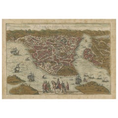
Byzantium Nunc Constantinopolis – Braun & Hogenberg View of Istanbul, 1572
Located in Langweer, NL
Byzantium Nunc Constantinopolis – Braun & Hogenberg View of Istanbul, Cologne, 1572
This iconic 16th-century bird’s-eye view titled “Byzantium Nunc Constantinopolis” presents the ci...
Category
Antique 16th Century German Maps
Materials
Paper
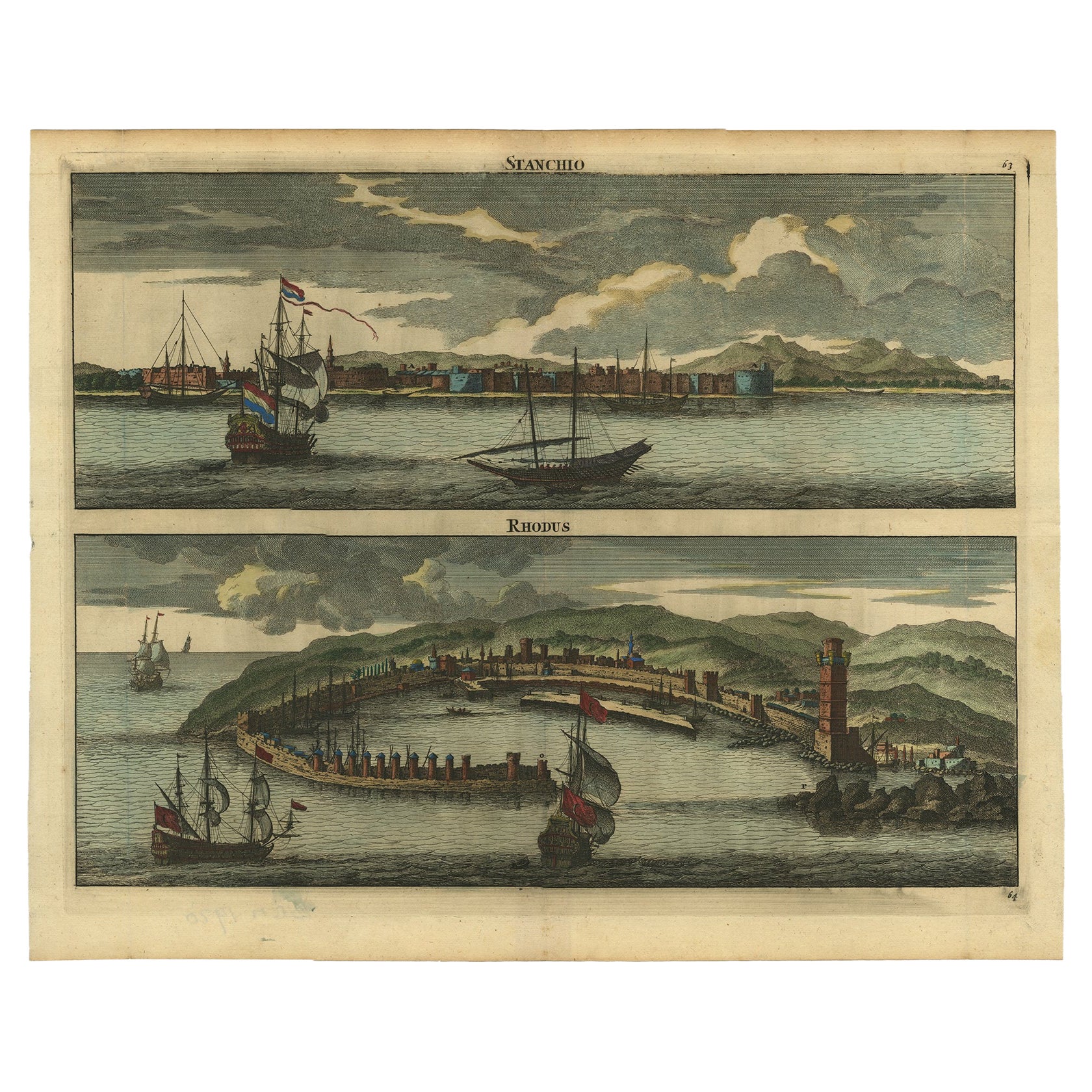
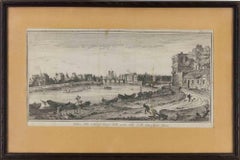
Rare & Old Panoramic Views of Stanchio, Greece and the Island of Rhodes, 1698
Located in Langweer, NL
Antique print titled Stanchio Rhodus.
Original antique print showing panoramic views of Stanchio, Greece and the Island of Rhodes, both with ships.
First edition in French, firs...
Category
Antique 1690s Dutch Prints
Materials
Paper
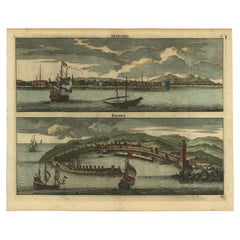
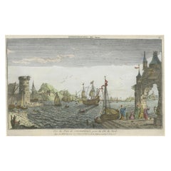
Contemporary Handcolored Optical View of Constantinople, ca.1760
Located in Langweer, NL
"Vue du Port de Constantinople, prise du côté du Nord". Contemporary handcolored optical view, Paris, J. Chereau, ±1760.
Description: This contemporary handcolored optical view, tit...
Category
Antique 1760s Prints
Materials
Paper
$856 Sale Price
20% Off
You May Also Like
Laurie and Whittle - 1794 Engraving, A General View of the City of Lisbon
Located in Corsham, GB
A vibrant and captivating print depicting an expansive view of Lisbon, with ships sailing in the foreground. Inscribed within the plate below the image. On paper.
Category
Early 18th Century Landscape Prints
Materials
Engraving
Ancient View of Constantinople - Original Lithograph - Mid-19th Century
Located in Roma, IT
Ancient View of Costantinople is an original modern artwork realized in the first half of the 19th Century.
Original B/W Lithograph on Ivory Paper.
Inscripted on the lower margin ...
Category
Early 19th Century Old Masters Figurative Prints
Materials
Lithograph
18th Century French Map and City View of Joppe/Jaffa (Tel Aviv) by Sanson
By Nicholas Sanson d'Abbeville
Located in Alamo, CA
An original antique engraving entitled "Joppe; in ’t Hebreeusch by ouds Japho; hedendaags Japha, of Jaffa; volgens d’aftekening gedaan 1668", by Nicholas Sanson d'Abbeville (1600 - 1667). This is a view of the city of Joppe (in Hebrew Japho), now called Japha or Jaffa, the harbor portion of modern day Tel Aviv, Israel as it appeared in 1668 . It depicts a very busy harbor with numerous boats. A large ship on the left appears to be firing its canons and a small ship on the right appears to be sitting very low in the water, either heavily loaded with cargo or sinking. The town is seen on the far shore with a fortress on a hill across in the background. The map is printed from the original Sanson copperplate and was published in 1709 by his descendants.
The map is presented in an ornate brown wood frame embellished by gold-colored leaves and gold inner trim with a double mat; the outer mat is cream-colored and the inner mat is black. There is a central vertical fold, as issued. There are two small spots in the lower margin and one in the upper margin, as well as two tiny spots adjacent to the central fold. 1717 is written below the date 1668 in the inscription. The map is otherwise in very good condition.
Another map of the "Holy Land" (by Claes Visscher in 1663), with an identical style frame and mat is available. This pair of maps would make a wonderful display grouping. Please see Reference #LU117324709892.
Artist: Nicholas Sanson d'Abbeville (1600 - 1667) and his descendents were important French cartographer's active through the 17th century. Sanson started his career as a historian and initially utilized cartography to illustrate his historical treatises. His maps came to the attention of Cardinal Richelieu and then King Louis XIII of France, who became a supporter and sponsor. He subsequently appointed Sanson 'Geographe Ordinaire du Roi' the official map maker to the king. Sanson not only created maps for the king, but advised him on geographical issues and curated his map collection...
Category
Early 1700s Prints and Multiples
Materials
Engraving

17th Century Topographical Engraving Nantes & St. Malo, France, by Iohan Peeters
Located in New York, NY
The ancient city of Saint Malo in North Western France has long been associated with adventure on the high seas, piracy and exploration. It was the birthplace of several important in...
Category
Antique 17th Century Dutch Maps
Materials
Paper

17th Century Toulouse, Savve, Sommieres Topographical Map by Iohan Peeters
Located in New York, NY
Fine topographical 17th century map of Toulouse, Savve and Sommieres by Iohan Peeters
Beautiful engraving of the capital of France's Occitanie Region, Toulouse, called La Ville Rose- the Pink City, for the terracotta bricks used in its many buildings, giving the city a distinct apricot-rose hue. An important cultural and educational center, the city's residents included Nobel Prize winners and world renown artists- Henri de Toulouse-Lautrec, Henri Martin, Jean-Auguste-Dominique Ingres, Antonin Mercie, Alexandre Falguiere and more recently Cyril Kongo...
Category
Antique 17th Century Dutch Maps
Materials
Paper

View of the City of Paris from the side of the island called... - Etching - 1748
Located in Roma, IT
Etching on paper realized in 1748.
Very good condition except for some minor foxing.
Includes a wooden frame cm. 27.5x41.5
Category
1740s Modern Abstract Prints
Materials
Etching
$252 Sale Price
25% Off
More Ways To Browse
Antique Compendium
Istanbul Antique
Ottoman Robe
Pair Of Danish Chairs
Veneer Dining Tables
1970 Italian Armchair
Furniture Uk
House Of Denmark Table And Chairs
Louis Marble Top Side Table
Antique Russian Rugs
Baker Furniture By
For Kids
Sterling Silver Flatware Set Service For 12
Tufted Bar
Pair Of French Antique Armchairs
1970s Brass Glass Coffee Table
Antique Column Base
Charles Rennie Mackintosh For Cassina