Items Similar to Map of Aisne France with Soissons and Champagne Vineyards by Vuillemin, 19th c


Want more images or videos?
Request additional images or videos from the seller
1 of 10
Map of Aisne France with Soissons and Champagne Vineyards by Vuillemin, 19th c
$143.85
£106.86
€120
CA$199.75
A$217.98
CHF 114.33
MX$2,647.39
NOK 1,428.07
SEK 1,349.60
DKK 913.55
About the Item
Map of Aisne France with Soissons and Champagne Vineyards by Vuillemin, 19th c
Description:
This richly detailed 19th-century engraved and hand-colored map of the department of Aisne in northern France is part of Alexandre Vuillemin’s renowned Nouvel Atlas Illustré, published in Paris by Migeon. The map artfully combines cartographic precision with finely engraved vignettes, giving insight into the cultural and geographical identity of the region during the mid-1800s.
Aisne, located in the historical region of Picardy, is bordered by the departments of Nord, Ardennes, Marne, Seine-et-Marne, Oise, and Somme. The map features delicate pastel hand-coloring to delineate borders, along with a wealth of named towns, rivers, and roads. The surrounding vignette illustrations add a strong visual appeal and highlight notable landmarks and personalities from the area.
The lower left corner features a portrait of Louis Charles Auguste Le Tonnelier de Breteuil, a diplomat and minister of Louis XVI, who was born in Aisne. On the lower right is a charming rendering of Soissons, one of the department’s oldest and most historically significant towns, once a capital of the Frankish kingdom. To the left, the cathedral of Laon is beautifully engraved with Gothic architectural detail.
Aisne is also known as the western edge of the famed Champagne region. The southern part of the department, particularly around Château-Thierry, is part of the official Champagne Appellation d'Origine Contrôlée zone. Vineyards in this area contribute to the production of Pinot Meunier, one of the three primary grapes used in Champagne. The blend of pastoral landscapes, viticulture, and medieval architecture has made Aisne a lesser-known but culturally rich part of the Champagne heritage.
The engraver, Alexandre Vuillemin, was a respected French cartographer who specialized in decorative and educational maps in the 19th century. His maps are celebrated not only for their geographic accuracy but also for their artistic embellishments, often combining history, topography, and portraiture. The publisher, Migeon, was known for high-quality illustrated works, and this map reflects both scientific rigor and visual refinement.
Condition summary:
Very good antique condition with light age toning and minor foxing in the margins. Engraving remains crisp, and original hand coloring is intact and vibrant.
Framing tips:
Ideal for a traditional or classical interior, this map pairs well with a dark wood or gilt frame. Use a soft cream or parchment-toned mat to highlight the engraving and warm tones of the paper.
- Dimensions:Height: 12.8 in (32.5 cm)Width: 10.28 in (26.1 cm)Depth: 0.01 in (0.2 mm)
- Materials and Techniques:Paper,Engraved
- Place of Origin:
- Period:
- Date of Manufacture:circa 1850
- Condition:Very good antique condition with light age toning and minor foxing in the margins. Engraving remains crisp, and original hand coloring is intact and vibrant.
- Seller Location:Langweer, NL
- Reference Number:Seller: BG-13331-21stDibs: LU3054345359072
About the Seller
5.0
Recognized Seller
These prestigious sellers are industry leaders and represent the highest echelon for item quality and design.
Platinum Seller
Premium sellers with a 4.7+ rating and 24-hour response times
Established in 2009
1stDibs seller since 2017
2,641 sales on 1stDibs
Typical response time: <1 hour
- ShippingRetrieving quote...Shipping from: Langweer, Netherlands
- Return Policy
Authenticity Guarantee
In the unlikely event there’s an issue with an item’s authenticity, contact us within 1 year for a full refund. DetailsMoney-Back Guarantee
If your item is not as described, is damaged in transit, or does not arrive, contact us within 7 days for a full refund. Details24-Hour Cancellation
You have a 24-hour grace period in which to reconsider your purchase, with no questions asked.Vetted Professional Sellers
Our world-class sellers must adhere to strict standards for service and quality, maintaining the integrity of our listings.Price-Match Guarantee
If you find that a seller listed the same item for a lower price elsewhere, we’ll match it.Trusted Global Delivery
Our best-in-class carrier network provides specialized shipping options worldwide, including custom delivery.More From This Seller
View AllMap of Allier France with Saint-Pourçain Wine Region by Vuillemin, 19th c
Located in Langweer, NL
Map of Allier France with Saint-Pourçain Wine Region by Vuillemin, 19th c
This decorative 19th-century map of Allier, a central department of France, comes from the celebrated Nouve...
Category
Antique Mid-19th Century French Maps
Materials
Paper

Map of Aube France with Troyes and Champagne Wine Region, 19th Century
Located in Langweer, NL
Map of Aube France with Troyes and Champagne Vineyards by Vuillemin, 19th c
Description:
This 19th-century map of the Aube department in the Grand Est region of northeastern France ...
Category
Antique Mid-19th Century French Maps
Materials
Paper

Map of Ardèche France with Annonay and Vineyards by Vuillemin, 19th c
Located in Langweer, NL
Map of Ardèche France with Annonay and Vineyards by Vuillemin, 19th c
This beautifully engraved 19th-century map of Ardèche, a department in southeastern France, comes from Alexandr...
Category
Antique Mid-19th Century French Maps
Materials
Paper

Map of Ain France with Vineyards of Bugey and Notable Portraits, c.1850
Located in Langweer, NL
Map of Ain France with Portraits of Bichat and Joubert by Vuillemin, 19th c
This highly decorative 19th-century map of the French department of Ain is taken from the celebrated Nouv...
Category
Antique Mid-19th Century French Maps
Materials
Paper

Map of Gard France with Pont du Gard and Wine Regions by Vuillemin, 19th c
Located in Langweer, NL
Title: Map of Gard France with Pont du Gard and Wine Regions by Vuillemin, 19th c
Description:
This finely engraved 19th-century map of the department of Gard in southern France was...
Category
Antique Mid-19th Century French Maps
Materials
Paper

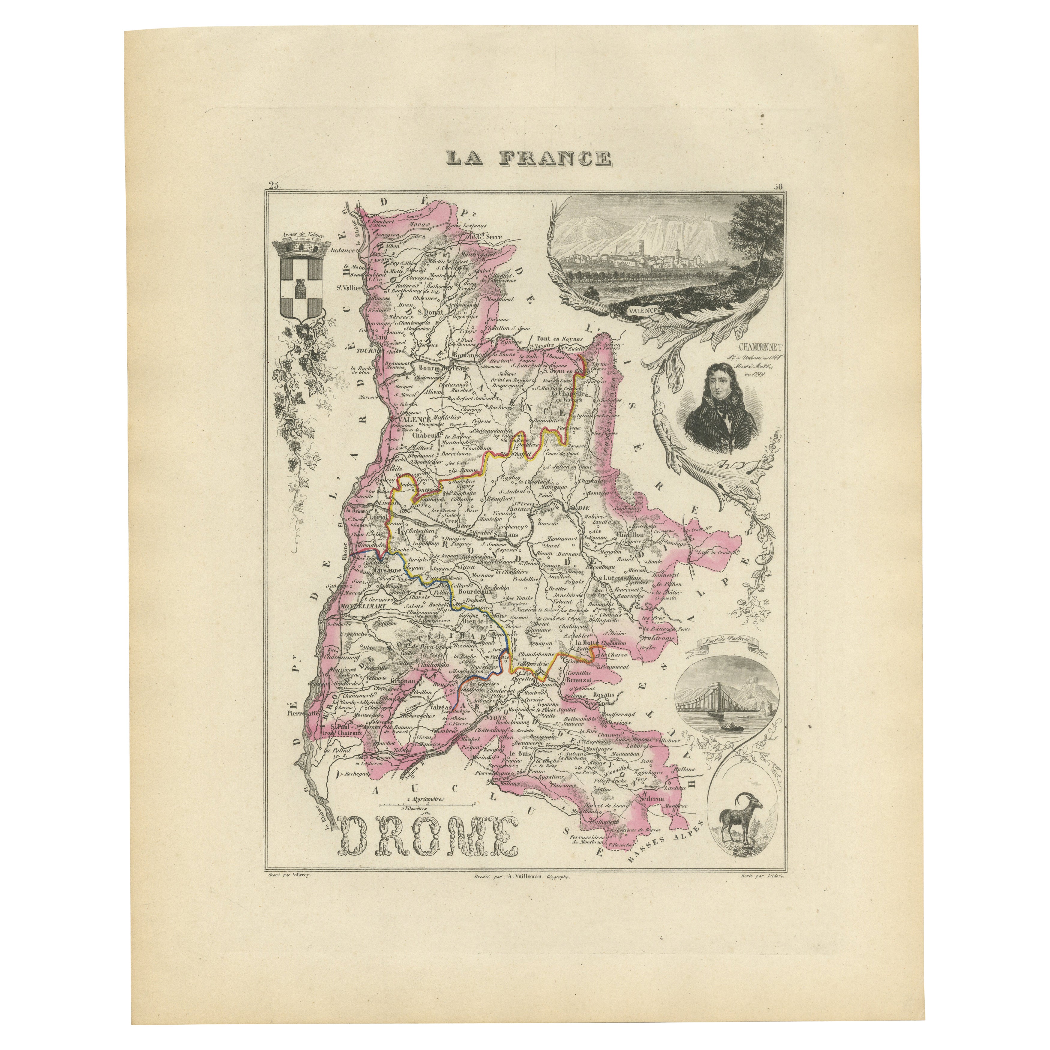
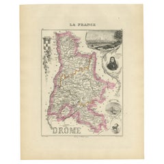
Map of Drôme France with Valence and Rhône Valley Wine Region, 19th Century
Located in Langweer, NL
Map of Drôme France with Valence and Rhône Valley Wine Region, 19th Century
Description:
This beautifully engraved 19th-century map of the Drôme department in southeastern France wa...
Category
Antique Mid-19th Century French Maps
Materials
Paper
You May Also Like
Saone and Loire, France. Antique map of a French department, 1856
By Victor Levasseur
Located in Melbourne, Victoria
'Dept. de Saone et Loire', steel engraving with original outline hand-colouring., 1856, from Levasseur's Atlas National Illustre.
The French department of Saone et Loire is at the ...
Category
19th Century Naturalistic Landscape Prints
Materials
Engraving

Large 19th Century Map of France
Located in Pease pottage, West Sussex
Large 19th Century Map of France.
Remarkable condition, with a pleasing age worn patina.
Recently framed.
France Circa 1874.
Category
Antique Late 19th Century French Maps
Materials
Linen, Paper

Map of Haute Vienne - Original Lithograph - 19th Century
Located in Roma, IT
Map of Haute Vienne is an original lithograph artwork realized by an Anonymous engraver of the 19th century.
Printed in the series of "France Pittoresque".
Titled "France Pittore...
Category
19th Century Modern Figurative Prints
Materials
Lithograph

Indre and Loire, France. Antique map of a French department, 1856
By Victor Levasseur
Located in Melbourne, Victoria
'Dept. d'Indre et Loire', steel engraving with original outline hand-colouring., 1856, from Levasseur's 'Atlas National Illustre'.
This area is known for its production of Chenin b...
Category
19th Century Naturalistic Landscape Prints
Materials
Engraving

Lozere, France. Antique map of a French department, 1856
By Victor Levasseur
Located in Melbourne, Victoria
'Dept. de La Lozere', steel engraving with original outline hand-colouring., 1856, from Levasseur's 'Atlas National Illustre'.
This remote mountainous part of Languedoc is rural, s...
Category
19th Century Naturalistic Landscape Prints
Materials
Engraving

Aude, France. Antique map of a French department, 1856
By Victor Levasseur
Located in Melbourne, Victoria
'Dept. de L' Aude', steel engraving with original outline hand-colouring., 1856, from Levasseur's 'Atlas National Illustre'.
This area of France is famous for its wide variety of v...
Category
19th Century Naturalistic Landscape Prints
Materials
Engraving

More Ways To Browse
Vineyard Furniture
Cream Soup
Early English Silver
Paisley Rugs and Carpets
Black And Chrome Lounge Chair
Vintage 1930 Dining Room Set
Antique Brass And Copper
Antique Cow
Antique Harvest
Antique Victorian Dining Tables
Environment Furniture
Italian Plastic Chairs
Made In Belgium
Black Crystal Glasses
French Mid Century Modern Rug
China Silk Rug
Chrome Glass Coffee Tables
Antique Italian Chairs