Items Similar to Map of Ardèche France with Annonay and Vineyards by Vuillemin, 19th c


Want more images or videos?
Request additional images or videos from the seller
1 of 11
Map of Ardèche France with Annonay and Vineyards by Vuillemin, 19th c
$143.85
£106.86
€120
CA$199.75
A$217.98
CHF 114.33
MX$2,647.39
NOK 1,428.07
SEK 1,349.60
DKK 913.55
About the Item
Map of Ardèche France with Annonay and Vineyards by Vuillemin, 19th c
This beautifully engraved 19th-century map of Ardèche, a department in southeastern France, comes from Alexandre Vuillemin’s *Nouvel Atlas Illustré*, published in Paris by Migeon. The map offers a detailed and artistic representation of the region, enhanced by vignettes, coats of arms, and historical references that highlight Ardèche’s cultural and natural richness.
The map presents the department’s full geographical scope with towns, rivers, and road networks, bordered by hand-applied yellow watercolor. Key locations such as Annonay, Privas, and Aubenas are clearly marked. The engraving also depicts the rugged terrain for which the Ardèche is well known, including the mountainous Massif Central and deep river gorges. In the upper left is a vignette of the town of Annonay, famous as the birthplace of the Montgolfier brothers, pioneers of balloon flight. Below that is a depiction of the natural stone arch of the Pont d’Arc, one of the most iconic landmarks in the region.
In the lower right corner, a striking scene depicts Joseph Marie Jacquard presenting his invention of the Jacquard loom, symbolizing Ardèche’s historical contributions to the textile industry. Jacquard’s automated loom was a key innovation in the development of modern weaving.
Ardèche is also a celebrated wine-producing region, especially in the southern part of the department near the Rhône Valley. The area is known for its rustic, characterful wines, including red blends made from Grenache, Syrah, and Merlot, as well as fresh white wines from Viognier and Chardonnay grapes. These wines are often labeled under the Côtes du Vivarais and Coteaux de l’Ardèche designations. The region’s climate and diverse terroirs make it an increasingly respected area within the Rhône wine landscape.
Alexandre Vuillemin, a skilled 19th-century French cartographer, was renowned for blending geography with artistic and cultural elements in his maps. His works were both decorative and informative, aimed at a growing educated public. The publisher, Migeon, was known for high-quality atlases that brought historical and geographic knowledge to a broad audience.
Condition summary:
Excellent impression with mild toning to the edges and a few small, scattered foxing marks. The hand-coloring remains vivid and the engraving is sharp and detailed.
Framing tips:
A classic dark wood or olive-toned frame will highlight the natural character of the Ardèche region. A warm off-white or light tan mat works well to emphasize the yellow hand-coloring. Use UV-protective glass for preservation.
- Dimensions:Height: 10.28 in (26.1 cm)Width: 12.8 in (32.5 cm)Depth: 0.01 in (0.2 mm)
- Materials and Techniques:Paper,Engraved
- Place of Origin:
- Period:
- Date of Manufacture:circa 1850
- Condition:Excellent impression with mild toning to the edges and a few small, scattered foxing marks. The hand-coloring remains vivid and the engraving is sharp and detailed.
- Seller Location:Langweer, NL
- Reference Number:Seller: BG-13331-61stDibs: LU3054345359162
About the Seller
5.0
Recognized Seller
These prestigious sellers are industry leaders and represent the highest echelon for item quality and design.
Platinum Seller
Premium sellers with a 4.7+ rating and 24-hour response times
Established in 2009
1stDibs seller since 2017
2,641 sales on 1stDibs
Typical response time: <1 hour
- ShippingRetrieving quote...Shipping from: Langweer, Netherlands
- Return Policy
Authenticity Guarantee
In the unlikely event there’s an issue with an item’s authenticity, contact us within 1 year for a full refund. DetailsMoney-Back Guarantee
If your item is not as described, is damaged in transit, or does not arrive, contact us within 7 days for a full refund. Details24-Hour Cancellation
You have a 24-hour grace period in which to reconsider your purchase, with no questions asked.Vetted Professional Sellers
Our world-class sellers must adhere to strict standards for service and quality, maintaining the integrity of our listings.Price-Match Guarantee
If you find that a seller listed the same item for a lower price elsewhere, we’ll match it.Trusted Global Delivery
Our best-in-class carrier network provides specialized shipping options worldwide, including custom delivery.More From This Seller
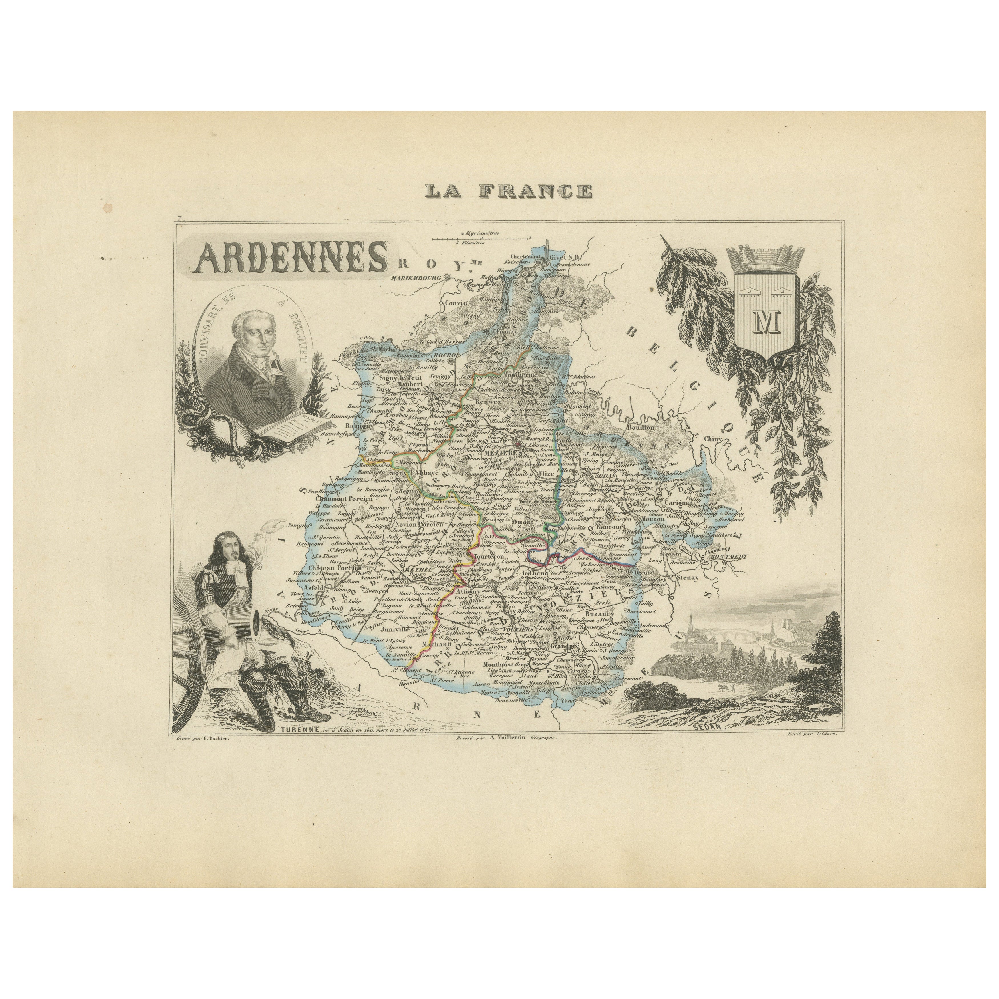
View AllMap of Ardennes France with Sedan and Military History by Vuillemin, c.1850
Located in Langweer, NL
Map of Ardennes France with Sedan and Military History by Vuillemin, 19th c
Description:
This detailed and decorative 19th-century map of the Ardennes department in northeastern Fra...
Category
Antique Mid-19th Century French Maps
Materials
Paper
Map of Aisne France with Soissons and Champagne Vineyards by Vuillemin, 19th c
Located in Langweer, NL
Map of Aisne France with Soissons and Champagne Vineyards by Vuillemin, 19th c
Description:
This richly detailed 19th-century engraved and hand-colored map of the department of Aisn...
Category
Antique Mid-19th Century French Maps
Materials
Paper

Map of Aveyron France with Rodez, Millau and Wine Routes, 19th Century
Located in Langweer, NL
Map of Aveyron France with Rodez, Millau and Wine Routes, 19th Century
Description:
This detailed and decorative 19th-century map of Aveyron, a department in southern France, was dr...
Category
Antique Mid-19th Century French Maps
Materials
Paper
Map of Allier France with Saint-Pourçain Wine Region by Vuillemin, 19th c
Located in Langweer, NL
Map of Allier France with Saint-Pourçain Wine Region by Vuillemin, 19th c
This decorative 19th-century map of Allier, a central department of France, comes from the celebrated Nouve...
Category
Antique Mid-19th Century French Maps
Materials
Paper

Map of Gard France with Pont du Gard and Wine Regions by Vuillemin, 19th c
Located in Langweer, NL
Title: Map of Gard France with Pont du Gard and Wine Regions by Vuillemin, 19th c
Description:
This finely engraved 19th-century map of the department of Gard in southern France was...
Category
Antique Mid-19th Century French Maps
Materials
Paper

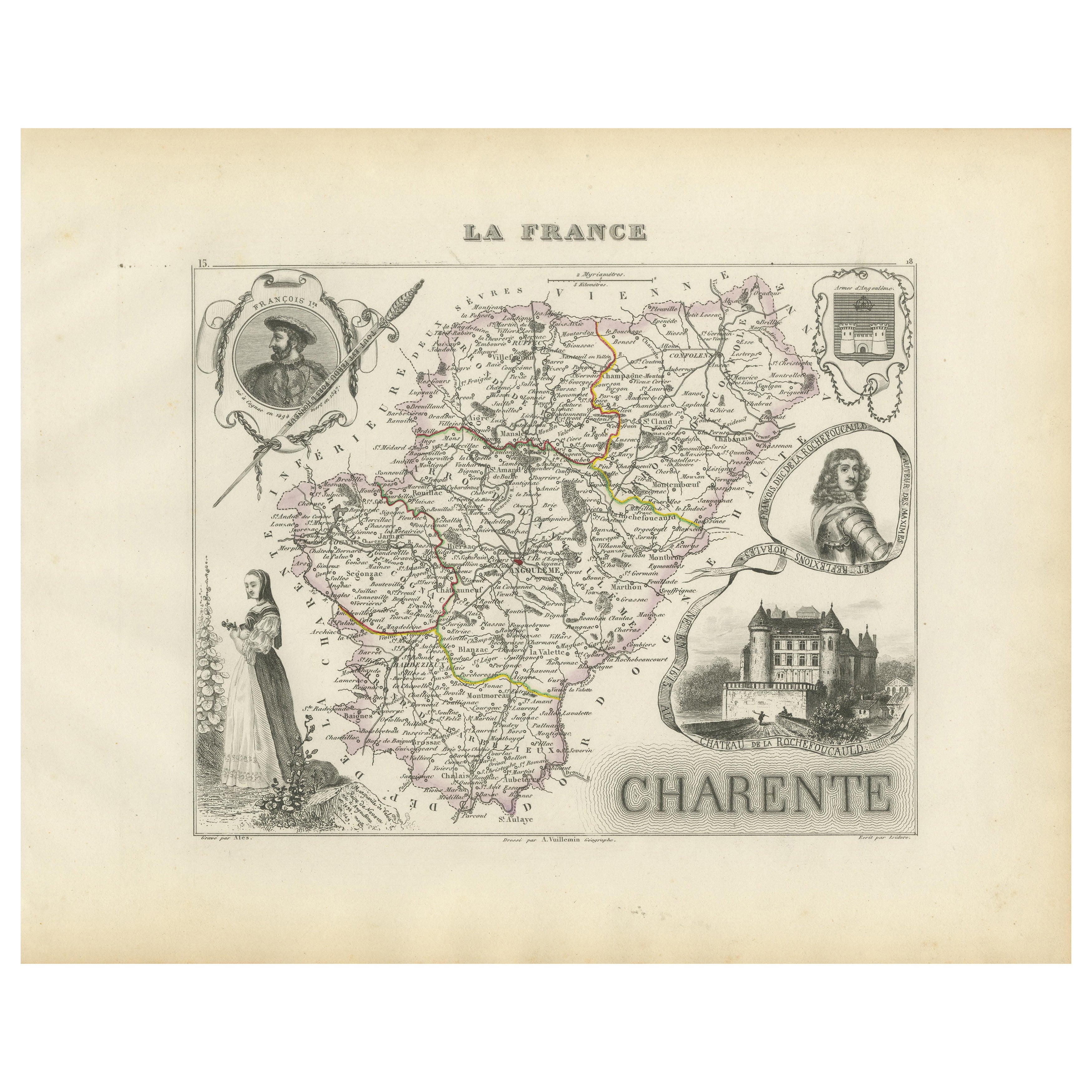
Map of Charente France with Cognac Region and Château de La Rochefoucauld, 1850
Located in Langweer, NL
Map of Charente France with Cognac Region and Château de La Rochefoucauld, 19th c
Description:
This richly illustrated 19th-century map of the Charente department in southwestern Fr...
Category
Antique Mid-19th Century French Maps
Materials
Paper

You May Also Like
Aude, France. Antique map of a French department, 1856
By Victor Levasseur
Located in Melbourne, Victoria
'Dept. de L' Aude', steel engraving with original outline hand-colouring., 1856, from Levasseur's 'Atlas National Illustre'.
This area of France is famous for its wide variety of v...
Category
19th Century Naturalistic Landscape Prints
Materials
Engraving

Var, France. Antique map of a French department, 1856
By Victor Levasseur
Located in Melbourne, Victoria
'Dept. du Var', steel engraving with original outline hand-colouring., 1856, from Levasseur's Atlas National Illustre.
Var covers the heart of the French Riviera or Cote d'Azur., and includes the resort cities of Cannes, Nice and San Tropez...
Category
19th Century Naturalistic Landscape Prints
Materials
Engraving

Lozere, France. Antique map of a French department, 1856
By Victor Levasseur
Located in Melbourne, Victoria
'Dept. de La Lozere', steel engraving with original outline hand-colouring., 1856, from Levasseur's 'Atlas National Illustre'.
This remote mountainous part of Languedoc is rural, s...
Category
19th Century Naturalistic Landscape Prints
Materials
Engraving

L'Isere, France. Antique map of French department, 1856
By Victor Levasseur
Located in Melbourne, Victoria
'Dept. de L'Isere', Steel engraving with original outline hand-colouring., 1856, from Levasseur's 'Atlas National Illustre'.
This area is known for its production of Bleu du Vercor...
Category
19th Century Naturalistic Landscape Prints
Materials
Engraving

Aube, France. Antique map of a French department, 1856
By Victor Levasseur
Located in Melbourne, Victoria
'Dept. de L'Aube', steel engraving with original outline hand-colouring., 1856, from Levasseur's 'Atlas National Illustre'.
This area of France is known for its production of Chaou...
Category
19th Century Naturalistic Landscape Prints
Materials
Engraving

L'Herault, France. Antique map of a French department, 1856
By Victor Levasseur
Located in Melbourne, Victoria
'Dept. de Saone et Loire', steel engraving with original outline hand-colouring., 1856, from Levasseur's Atlas National Illustre.
This area is home to a wide variety of vineyards a...
Category
19th Century Naturalistic Landscape Prints
Materials
Engraving

More Ways To Browse
Antique Looms
Antique Inventions
Antique Wine Labels
Vineyard Furniture
Paisley Rugs and Carpets
Black And Chrome Lounge Chair
Vintage 1930 Dining Room Set
Antique Victorian Dining Tables
Environment Furniture
Italian Plastic Chairs
Made In Belgium
Black Crystal Glasses
French Mid Century Modern Rug
China Silk Rug
Chrome Glass Coffee Tables
Antique Italian Chairs
Antique Walnut Bar
Beni Ourain Rugs