Items Similar to Map of Zurich and Basel Region by Mercator, Uncolored Engraving c.1600


Want more images or videos?
Request additional images or videos from the seller
1 of 11
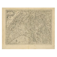
Map of Zurich and Basel Region by Mercator, Uncolored Engraving c.1600
$409.14
£302.91
€340
CA$566.48
A$618.46
CHF 324.23
MX$7,511.44
NOK 4,049.15
SEK 3,823.48
DKK 2,588.49
About the Item
Map of Zurich and Basel Region by Mercator, Uncolored Engraving c.1600
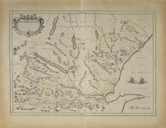
This original uncolored copperplate engraving, titled *Zurichgow et Basiliensis Provincia*, was created by the renowned cartographer Gerardus Mercator and published around 1600 in Amsterdam. The map presents a beautifully detailed rendering of the Swiss regions surrounding Zurich, Basel, and Lucerne, offering a rare early cartographic view of this alpine territory during the Renaissance.
Mercator, one of the most influential figures in the history of cartography, was born in Rupelmonde, Flanders in 1512 and educated in Louvain under the esteemed astronomer and mathematician Gemma Frisius. His scholarly rigor and precise engraving style earned him the patronage of Emperor Charles V. However, his Protestant sympathies led to charges of heresy during the Catholic persecution of Lutheran reformers. After a narrow escape from serious consequences, Mercator relocated to Duisburg in 1552, where he devoted the rest of his life to mapping, scientific instruments, and the production of his famous atlas.
The *Zurichgow et Basiliensis Provincia* map features a rich network of rivers, forests, and mountains depicted in stylized hachures typical of late 16th-century engravings. Key cities such as Zürich, Basel, and Lucerne are prominently marked, as are numerous small towns and geographic landmarks. This map was included in later editions of Mercator's *Atlas sive Cosmographicae*, the first modern atlas. After Mercator's death, his son Rumold carried on his legacy, and in 1604, the plates were acquired by Jodocus Hondius. Hondius and his sons expanded and reissued Mercator’s work, dominating European map publishing well into the mid-17th century.
This sheet is a fine example of early Swiss regional cartography, steeped in both artistic beauty and historical importance. The absence of color allows viewers to appreciate the delicate linework and engraving techniques of Mercator’s workshop.
Condition Report:
Uncolored engraving on laid paper, with even age toning and light spotting near the upper center. Vertical centerfold as issued. Minor edge wear but no tears or repairs. One brown spot, but strong impression and paper in stable condition.
Tips for Framing:
Frame in dark wood or gold-leaf with a cream or ivory archival mat to match the paper’s tone and enhance the historical lines. Avoid bright colors. Museum glass is recommended to protect the antique paper from light and moisture.
- Dimensions:Height: 17.52 in (44.5 cm)Width: 21.66 in (55 cm)Depth: 0.01 in (0.2 mm)
- Materials and Techniques:Paper,Engraved
- Period:Early 17th Century
- Date of Manufacture:circa 1600
- Condition:Good uncolored engraving on laid paper, with even age toning and light spotting near the upper center. Vertical centerfold as issued. Minor edge wear but no tears or repairs. One brown spot, but strong impression and paper in stable condition.
- Seller Location:Langweer, NL
- Reference Number:Seller: BG-13667-11stDibs: LU3054345323802
About the Seller
5.0
Recognized Seller
These prestigious sellers are industry leaders and represent the highest echelon for item quality and design.
Platinum Seller
Premium sellers with a 4.7+ rating and 24-hour response times
Established in 2009
1stDibs seller since 2017
2,641 sales on 1stDibs
Typical response time: <1 hour
- ShippingRetrieving quote...Shipping from: Langweer, Netherlands
- Return Policy
Authenticity Guarantee
In the unlikely event there’s an issue with an item’s authenticity, contact us within 1 year for a full refund. DetailsMoney-Back Guarantee
If your item is not as described, is damaged in transit, or does not arrive, contact us within 7 days for a full refund. Details24-Hour Cancellation
You have a 24-hour grace period in which to reconsider your purchase, with no questions asked.Vetted Professional Sellers
Our world-class sellers must adhere to strict standards for service and quality, maintaining the integrity of our listings.Price-Match Guarantee
If you find that a seller listed the same item for a lower price elsewhere, we’ll match it.Trusted Global Delivery
Our best-in-class carrier network provides specialized shipping options worldwide, including custom delivery.More From This Seller
View AllMap of Avenches Region Switzerland by Mercator, Original 1585 Engraving
Located in Langweer, NL
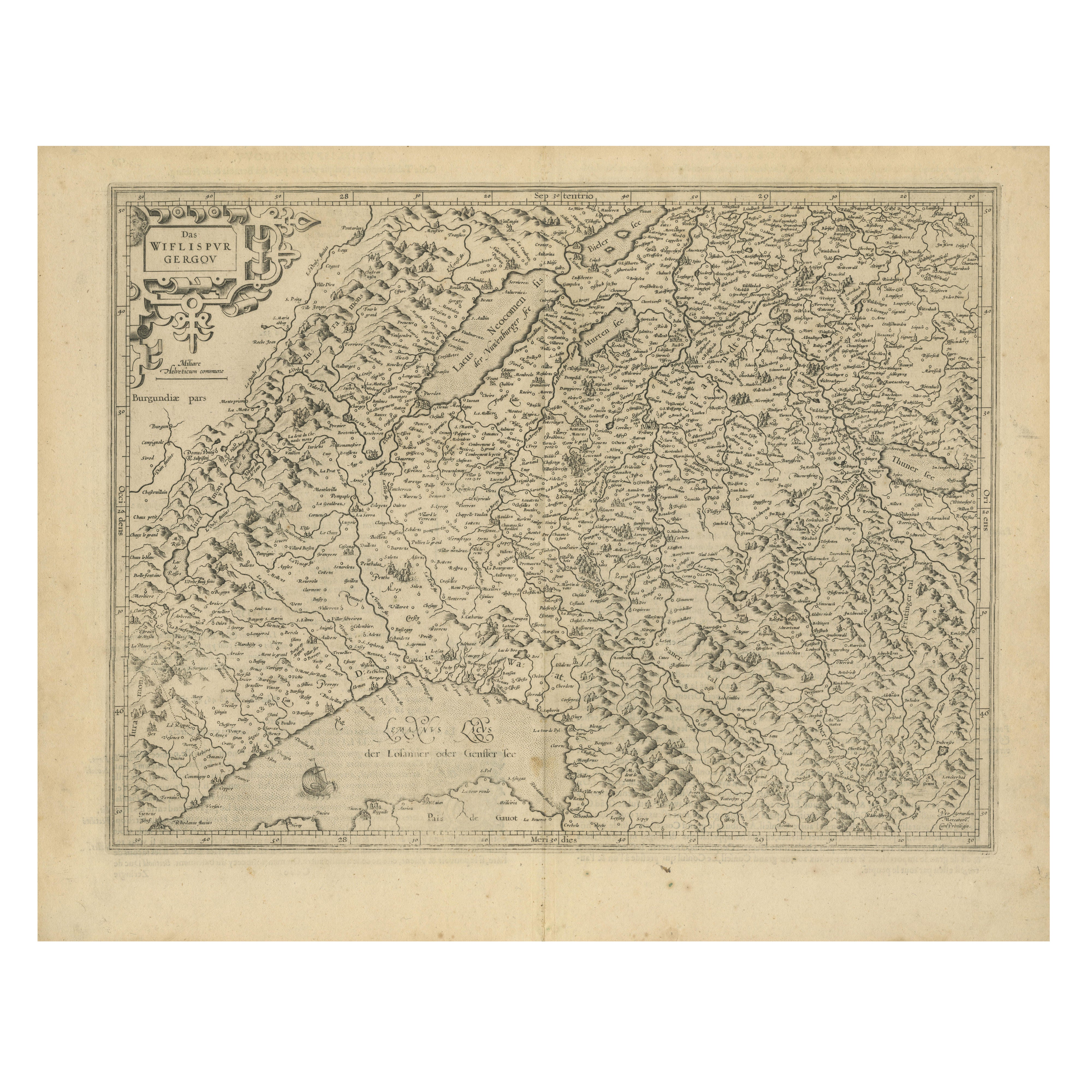
Map of Wiflispurgergov by Gerardus Mercator, Avenches Region, 1585
This rare and finely engraved map, titled *Das Wiflispurgergov*, was produced by Gerardus Mercator and published i...
Category
Antique 16th Century Dutch Maps
Materials
Paper
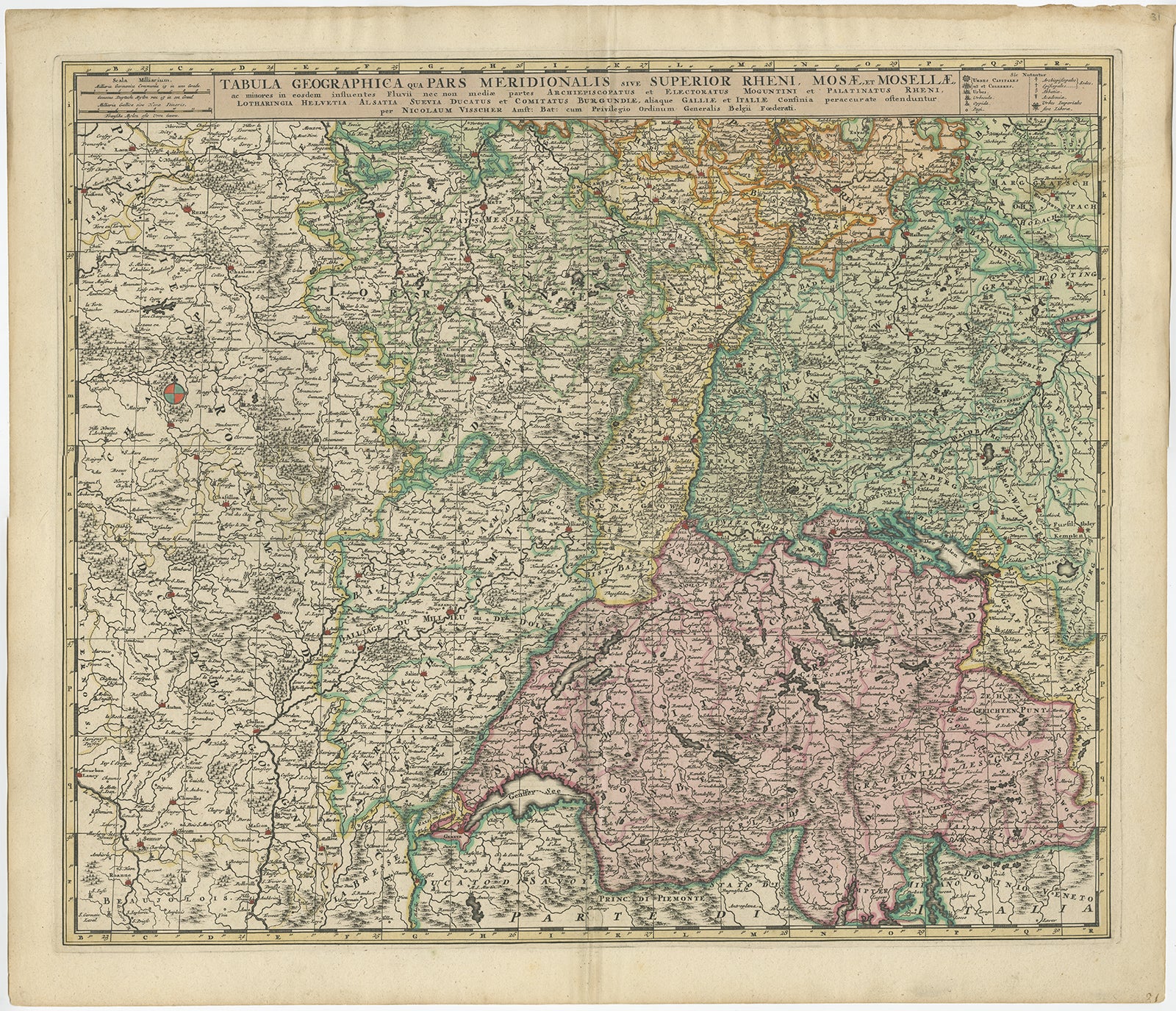
Antique Map of Switzerland by N. Visscher, circa 1690
Located in Langweer, NL
Antique map titled 'Tabula Geogaphica qua Pars Meridionalis sive Superior Rheni, Mosae, et Mosellae (..)'. Published by N. Visscher, Amsterdam, circa 1690. Contemporary coloring.
Category
Antique Late 17th Century Maps
Materials
Paper
$640 Sale Price
20% Off
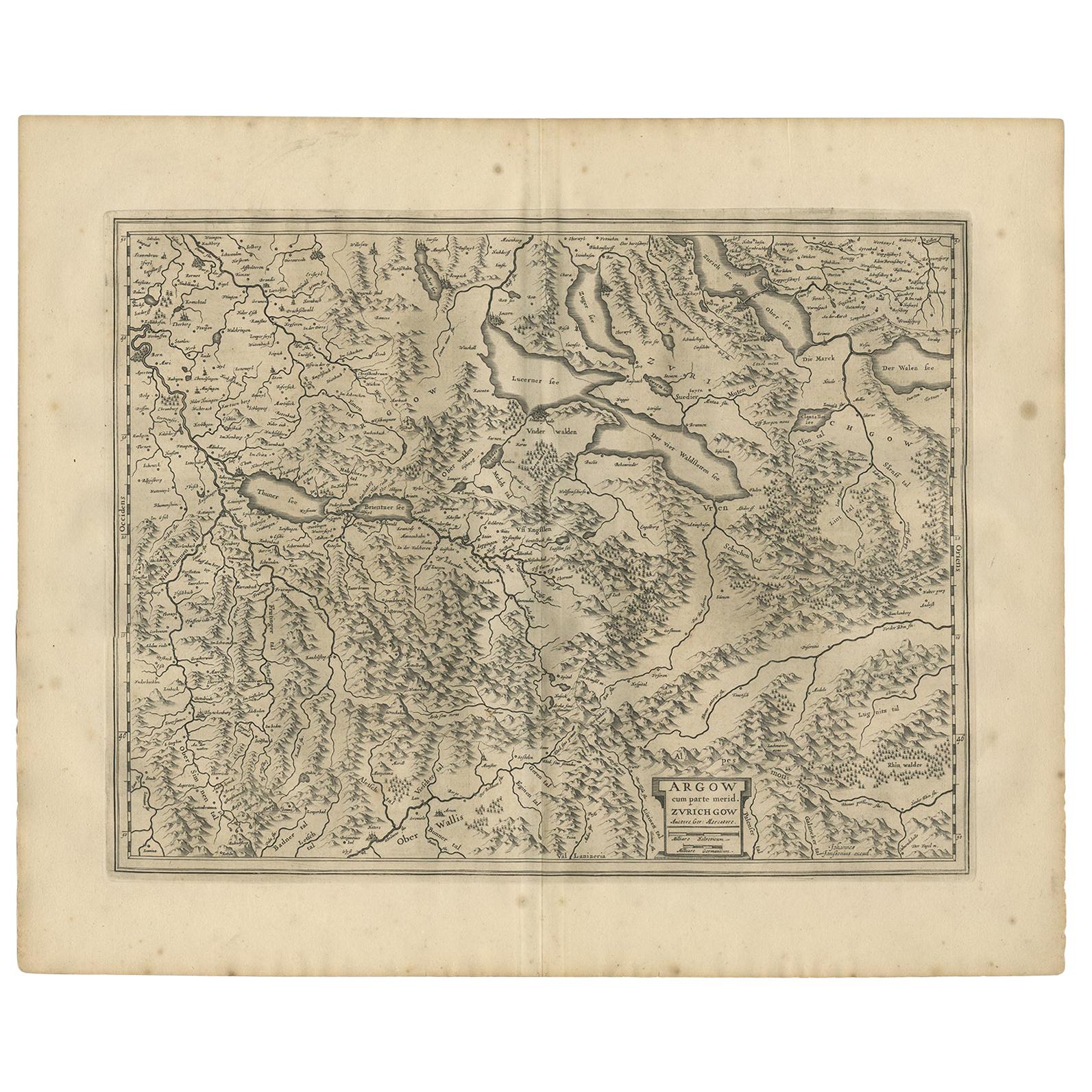
Antique Map of the Region of Aargau by Janssonius, '1657'
By Johannes Janssonius
Located in Langweer, NL
Antique map 'Argow cum parte merid. Zurichgow'. Detailed map of Switzerland showing Aargau with the southern part of Zürich. This map originates from 'Atlas Novus, Sive Theatrum Orbi...
Category
Antique Mid-17th Century Maps
Materials
Paper
$577 Sale Price
20% Off
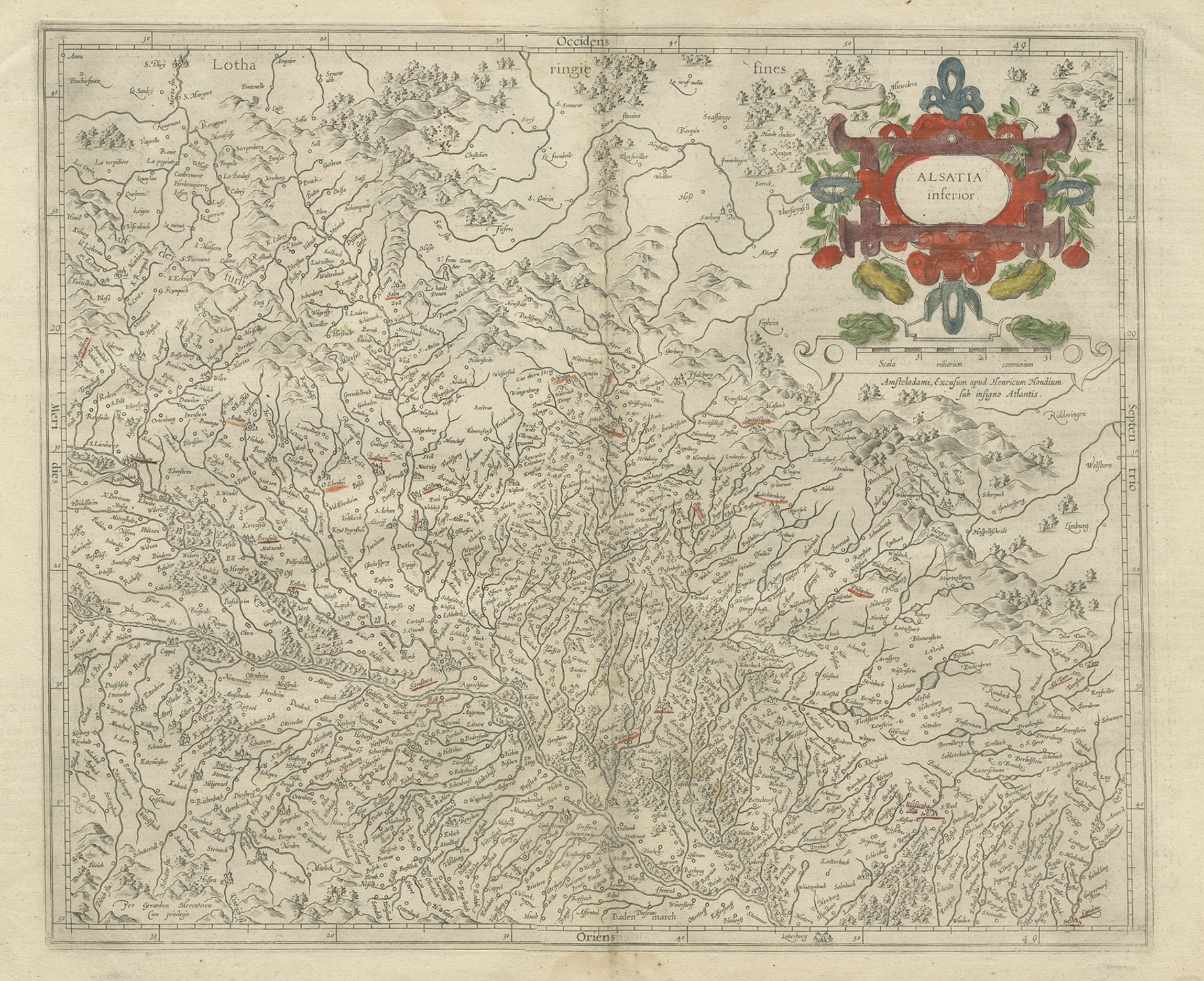
Antique Map of the Lower Alsace Region of France by Mapmaker Hondius, c.1630
Located in Langweer, NL
Antique map titled 'Alsatia Inferior'. Original antique map of the northern Alsace (Elzas) region of France. The map is centered on the course of the Rhine River, with Strasbourg at ...
Category
Antique 17th Century Maps
Materials
Paper
Antique Map of Northern Switzerland by Janssonius '1657'
By Johannes Janssonius
Located in Langweer, NL
Antique map 'Zurichgow et Basiliensis provincia'. Detailed map of northern Switzerland, including Zurich and Basel. This map originates from 'Atlas Novus, Sive Theatrum Orbis Orbis T...
Category
Antique Mid-17th Century Maps
Materials
Paper

$529 Sale Price
20% Off
Antique Map of Switzerland by Janssonius, 1657
Located in Langweer, NL
Antique map of Switzerland titled 'Helvetiae Rhetiae & Valesiae'. Decorative and detailed map of Switzerland. This map originates from 'Atla...
Category
Antique 17th Century Maps
Materials
Paper

$504 Sale Price
20% Off
You May Also Like
Original Antique Map of Switzerland, Engraved By Barlow, Dated 1807
Located in St Annes, Lancashire
Great map of Switzerland
Copper-plate engraving by Barlow
Published by Brightly & Kinnersly, Bungay, Suffolk.
Dated 1807
Unframed.
Category
Antique Early 1800s English Maps
Materials
Paper

Map of Switzerland - Etching - 19th Century
Located in Roma, IT
This map of Netherlands is an etching realized in 19th century.
The state of preservation of the artwork is excellent. The signature "F.B." is engraved on the lower right. At the to...
Category
19th Century Figurative Prints
Materials
Etching

Map of Scotland - Etching by Johannes Blaeu - 1650s
Located in Roma, IT
Map of Scotland is an geographic map realized by Johannes Blaeu.
Etching, printed in 1660 ca.
Copper engraving, colored (coeval coloring), on paper, with center fold;
Latin text. ...
Category
1650s Modern Figurative Prints
Materials
Etching
$451 Sale Price
20% Off
1657 Janssonius Map of Vermandois and Cappelle, Ric. A-004
Located in Norton, MA
1657 Janssonius map of
Vermandois and Cappelle
Ric.a004
Description: Antique map of France titled 'Descriptio Veromanduorum - Gouvernement de la Cappelle'. Two detailed maps o...
Category
Antique 17th Century Unknown Maps
Materials
Paper

Ancient Map - Macedonia - Etching by Johannes Janssonius - 1650s
By Johannes Janssonius
Located in Roma, IT
Macedonia is an ancient map realized in 1650 by Johannes Janssonius (1588-1664).
The Map is Hand-colored etching, with coeval watercoloring.
Good condit...
Category
1650s Modern Figurative Prints
Materials
Etching

Southerlandia Map - Etching by Johannes Janssonius - 1650
By Johannes Janssonius
Located in Roma, IT
Southerlandia Map is an ancient map realized in 1650 by Johannes Janssonius (1588-1664).
The Map is Hand-colored etching, with coeval watercoloring.
Good conditions.
From Atlantis...
Category
1650s Modern Figurative Prints
Materials
Etching

More Ways To Browse
Cream Soup
Early English Silver
Paisley Rugs and Carpets
Black And Chrome Lounge Chair
Vintage 1930 Dining Room Set
Antique Brass And Copper
Antique Cow
Antique Harvest
Antique Victorian Dining Tables
Environment Furniture
Italian Plastic Chairs
Made In Belgium
Black Crystal Glasses
French Mid Century Modern Rug
China Silk Rug
Chrome Glass Coffee Tables
Antique Italian Chairs
Antique Walnut Bar