Items Similar to Massachusetts Antique Map c.1888 – The Bay State, Railroads & Boston Inset

Video Loading
Want more images or videos?
Request additional images or videos from the seller
1 of 11
Massachusetts Antique Map c.1888 – The Bay State, Railroads & Boston Inset
$545.37
£408.15
€460
CA$752.39
A$836.69
CHF 439.45
MX$10,229.37
NOK 5,475.94
SEK 5,162.33
DKK 3,501.75
About the Item
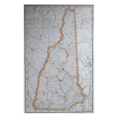
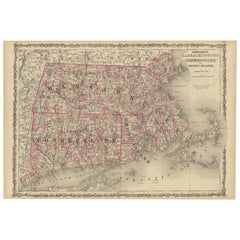
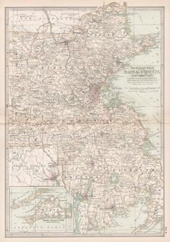
Antique Map of Massachusetts with Boston Inset – Rand McNally, circa 1888
This antique map of Massachusetts was published by Rand, McNally & Co. around 1888. It offers a detailed late 19th-century view of the Commonwealth, including its counties, towns, railroads, and major transportation networks.
The map covers the entire state, with Cape Cod and the islands of Martha’s Vineyard and Nantucket prominently engraved along the Atlantic coast. Major cities such as Boston, Worcester, Springfield, and Lowell are clearly marked, along with smaller towns and villages across the state.
Railroads dominate the map, shown in red and blue lines, illustrating Massachusetts’ role as one of the most connected and industrially advanced states of the period. The density of lines around Boston, Worcester, and Springfield highlights the state’s position as a hub of manufacturing, commerce, and higher education in the Gilded Age.
A particularly appealing feature is the inset of Boston and its vicinity, showing the city’s street grid, harbor, and surrounding towns in exceptional detail. This inset makes the map especially valuable for collectors of Boston or New England history.
The Atlantic coast is engraved with wave patterns, enhancing the decorative appeal. Combined with the precision of Rand McNally’s cartography, this map provides both a geographic record and a piece of visual history.
Condition report:
Very good condition with mild age toning. Original center fold as issued. Plate mark visible. Margins clean with only minor handling wear. Strong impression with vibrant outline coloring, particularly in the Boston inset.
Framing tips:
This map is ideal for display in a black or walnut frame with a cream mat. A double mat with ivory outer and muted blue inner will emphasize the Atlantic coastline and Boston Harbor inset, creating a balanced and elegant presentation.
Technique: Lithograph with original outline color
Maker: Rand, McNally & Co., Chicago, circa 1888
- Dimensions:Height: 14.18 in (36 cm)Width: 20.67 in (52.5 cm)Depth: 0.01 in (0.2 mm)
- Materials and Techniques:Paper,Engraved
- Place of Origin:
- Period:
- Date of Manufacture:1888
- Condition:Very good condition with mild age toning. Original center fold as issued. Plate mark visible. Margins clean with only minor handling wear. Strong impression with vibrant outline coloring, particularly in the Boston inset.
- Seller Location:Langweer, NL
- Reference Number:Seller: BG-12794-151stDibs: LU3054346475512
About the Seller
5.0
Recognized Seller
These prestigious sellers are industry leaders and represent the highest echelon for item quality and design.
Platinum Seller
Premium sellers with a 4.7+ rating and 24-hour response times
Established in 2009
1stDibs seller since 2017
2,607 sales on 1stDibs
Typical response time: <1 hour
- ShippingRetrieving quote...Shipping from: Langweer, Netherlands
- Return Policy
Authenticity Guarantee
In the unlikely event there’s an issue with an item’s authenticity, contact us within 1 year for a full refund. DetailsMoney-Back Guarantee
If your item is not as described, is damaged in transit, or does not arrive, contact us within 7 days for a full refund. Details24-Hour Cancellation
You have a 24-hour grace period in which to reconsider your purchase, with no questions asked.Vetted Professional Sellers
Our world-class sellers must adhere to strict standards for service and quality, maintaining the integrity of our listings.Price-Match Guarantee
If you find that a seller listed the same item for a lower price elsewhere, we’ll match it.Trusted Global Delivery
Our best-in-class carrier network provides specialized shipping options worldwide, including custom delivery.More From This Seller
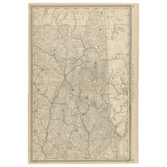
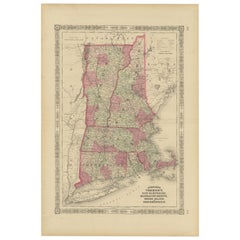
View AllNew Hampshire Antique Railroad Map c.1888 – Granite State Counties & Cities
Located in Langweer, NL
Antique Map of New Hampshire – Rand McNally, circa 1888
This antique map of New Hampshire was published by Rand, McNally & Co. around 1888. It provides a detailed late 19th-century ...
Category
Antique Late 19th Century American Maps
Materials
Paper
Rare 1864 Civil War Era Map of Massachusetts, Connecticut, and Rhode Island
Located in Langweer, NL
Title: Rare 1864 Civil War Era Map of Massachusetts, Connecticut, and Rhode Island
Description: This exquisite antique map, titled "Johnson's Massachusetts, Connecticut, and Rhode I...
Category
Antique 1860s Maps
Materials
Paper
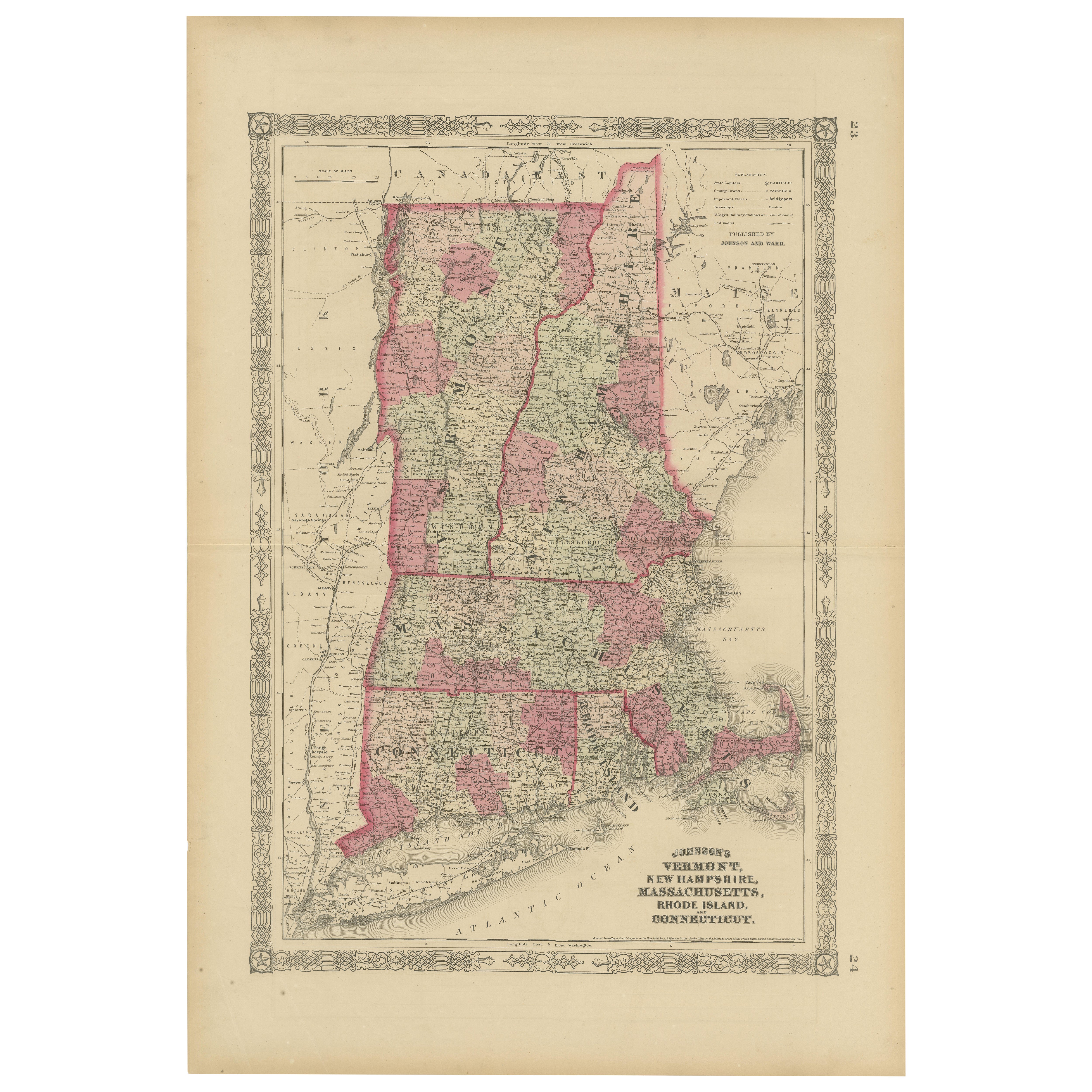
Rare 1864 Civil War Era Map of Vermont, New Hampshire, and Southern New England
Located in Langweer, NL
Title: Rare 1864 Civil War Era Map of Vermont, New Hampshire, and Southern New England
Description: This finely detailed antique map, titled "Johnson's Vermont, New Hampshire, Massa...
Category
Antique 1860s Maps
Materials
Paper
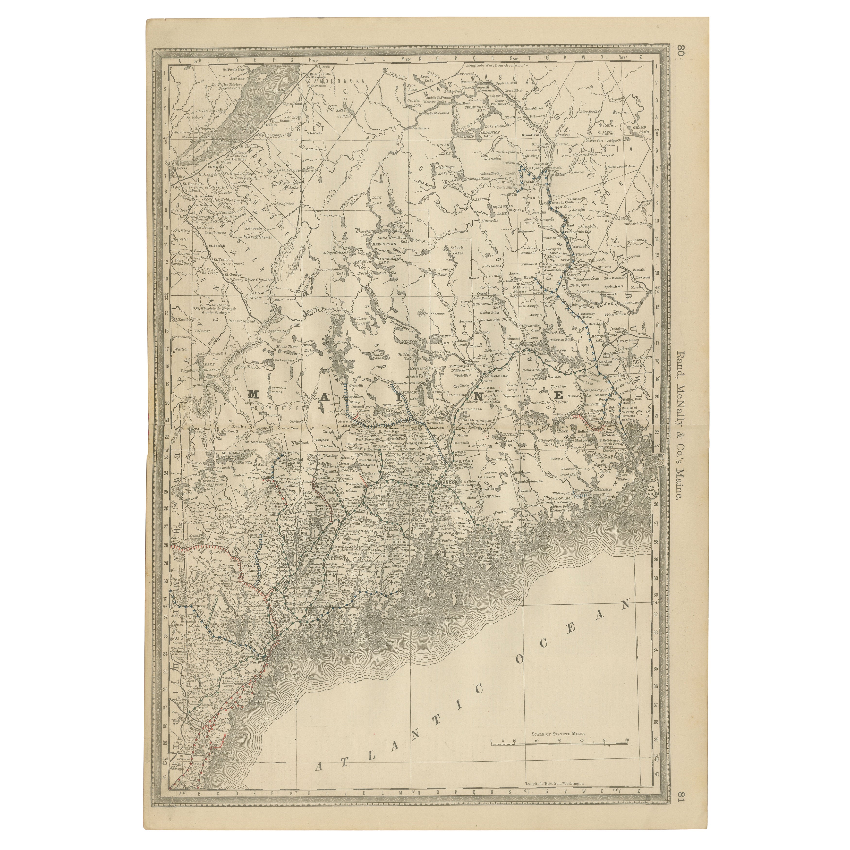
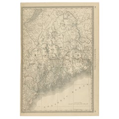
Maine Antique Railroad Map c.1888 – Pine Tree State Counties & Settlements
Located in Langweer, NL
Antique Map of Maine – Rand McNally, circa 1888
This antique map of Maine was published by Rand, McNally & Co. around 1888. It depicts the Pine Tree State in great detail, showing i...
Category
Antique Late 19th Century American Maps
Materials
Paper
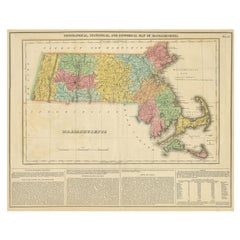
Antique Geographical, Historical and Statistical Map of Massachusetts, 1822
Located in Langweer, NL
This attractive map of Massachusetts presents a finely detailed overview of the state in the first quarter of the 19th century.
Transportation ...
Category
Antique 1820s Maps
Materials
Paper
$360 Sale Price
20% Off
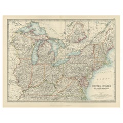
Antique Map of the Northeast USA - Vibrant 1903 Cartographic Detail
Located in Langweer, NL
Map of the Northeastern United States of North America, 1903
This striking antique map titled “United States of North America (North Eastern Sheet)” was created by the renowned Scot...
Category
Early 20th Century Maps
Materials
Paper
You May Also Like
Massachusetts, Eastern Part. USA. Century Atlas state antique vintage map
Located in Melbourne, Victoria
'The Century Atlas. Massachusetts, Eastern Part'
Original antique map, 1903.
Central fold as issued. Map name and number printed on the reverse corners.
Sheet 40cm by 29.5cm.
Category
Early 20th Century Victorian More Prints
Materials
Lithograph
Original Antique Map of the American State of Massachusetts, 1903
Located in St Annes, Lancashire
Antique map of Vermont and New Hampshire
Published By A & C Black. 1903
Original colour
Good condition
Unframed.
Free shipping
Category
Antique Early 1900s English Maps
Materials
Paper

Large Original Antique Map of Massachusetts, USA, circa 1900
Located in St Annes, Lancashire
Fabulous map of Massachusetts
In 2 sheets. They can be joined but I have not done it
Original color
Engraved and printed by the George F. Cram ...
Category
Antique 1890s American Maps
Materials
Paper

Maine. USA Century Atlas state antique vintage map
Located in Melbourne, Victoria
'The Century Atlas. Maine'
Original antique map, 1903.
Central fold as issued. Map name and number printed on the reverse corners.
Sheet 40cm by 29.5cm.
Category
Early 20th Century Victorian More Prints
Materials
Lithograph
Original Antique Map of the American State of Connecticut & Rhode Island, 1903
Located in St Annes, Lancashire
Antique map of Connecticut and Rhode Island
Published By A & C Black. 1903
Original colour
Good condition
Unframed.
Free shipping
Category
Antique Early 1900s English Maps
Materials
Paper

Large Original Antique Map of New Hampshire, USA, 1894
By Rand McNally & Co.
Located in St Annes, Lancashire
Fabulous map of New Hampshire
Original color
By Rand, McNally & Co.
Published, 1894
Unframed
Free shipping.
Category
Antique 1890s American Maps
Materials
Paper