Items Similar to New Jersey Antique Map – The Garden State, Railroads & Counties, c.1888

Video Loading
Want more images or videos?
Request additional images or videos from the seller
1 of 12
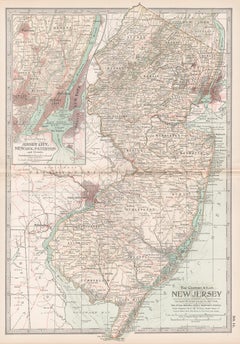
New Jersey Antique Map – The Garden State, Railroads & Counties, c.1888
$548.74
£405.69
€460
CA$754.78
A$838.99
CHF 439.78
MX$10,246.07
NOK 5,490.39
SEK 5,165.43
DKK 3,501.97
About the Item
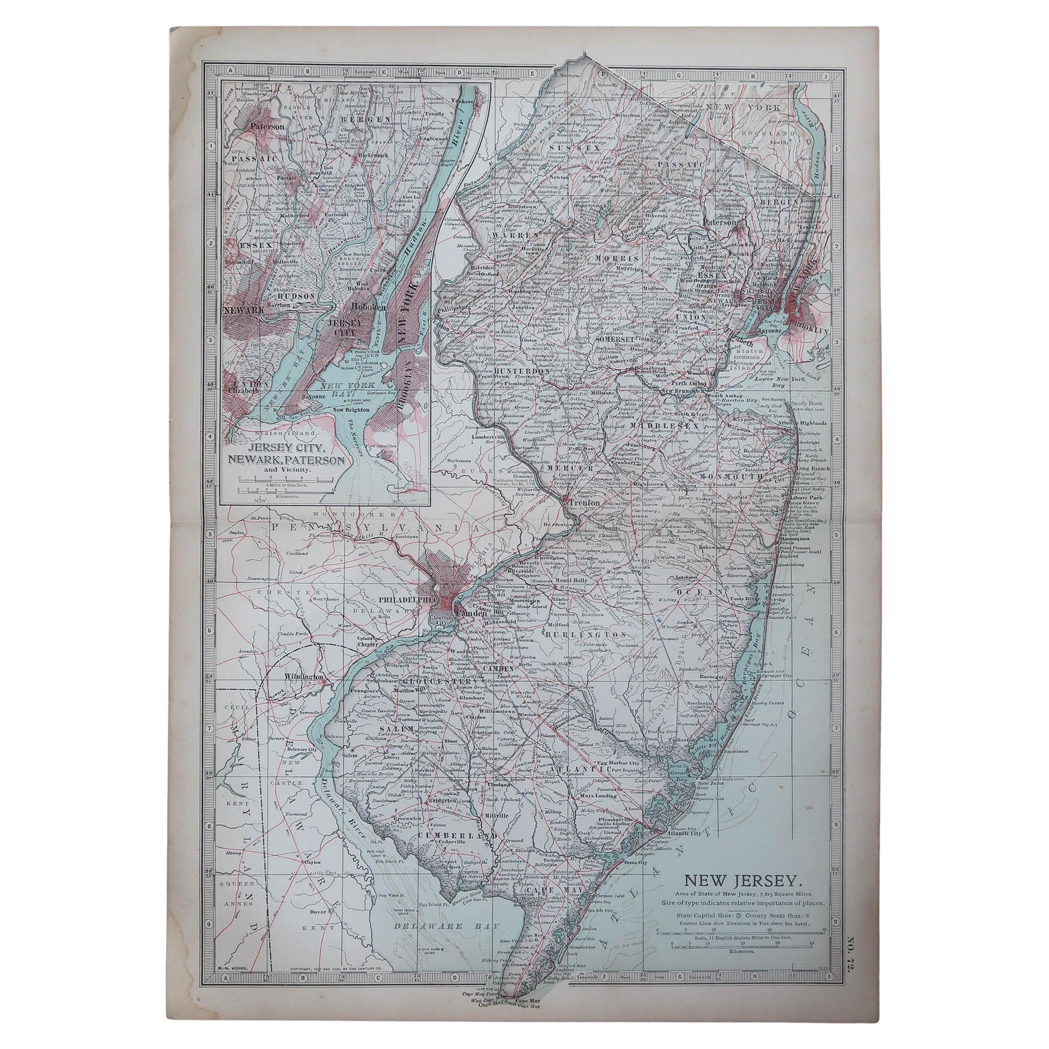
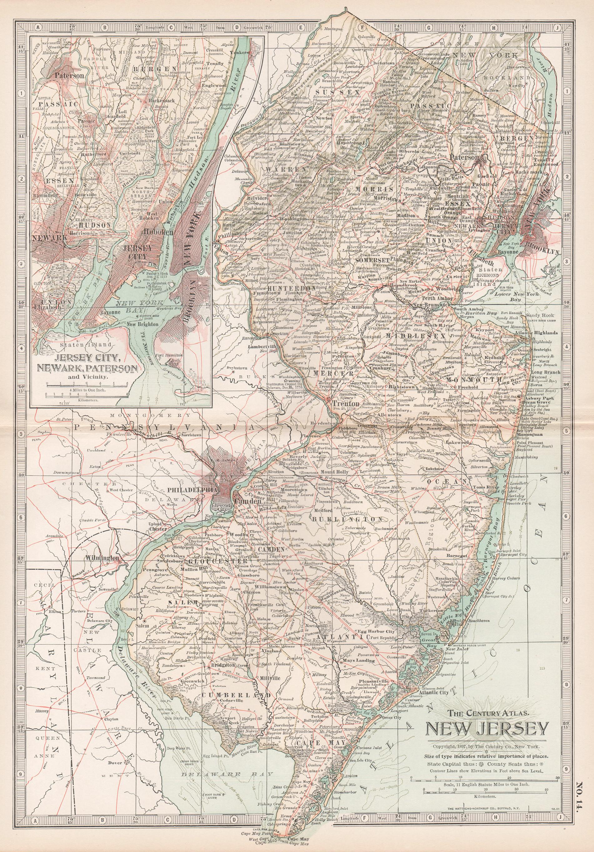
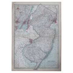
Antique Map of New Jersey – Rand McNally, circa 1888
This antique map of New Jersey was published by Rand, McNally & Co. around 1888. It offers a detailed late 19th-century portrait of the Garden State, highlighting its counties, towns, railroads, and waterways, as well as the critical links to New York and Philadelphia.
The map shows the entire state of New Jersey, with counties finely outlined and towns and villages clearly labeled. Railroads dominate the map, marked in red and blue, underscoring the state’s role as a transportation corridor between major metropolitan centers. The dense networks around Newark, Jersey City, Camden, and Trenton illustrate New Jersey’s rapid industrial and suburban growth during the Gilded Age.
Particularly appealing are the insets, including a detailed map of New York City and adjacent New Jersey, and an inset of the southern portion of the state. These provide a closer look at the heavily urbanized and economically vital areas, making this map both functional and decorative.
The Atlantic coast, from Sandy Hook to Cape May, is carefully engraved, reflecting New Jersey’s role as both a shipping hub and a seaside destination. Together, the geographic, industrial, and coastal elements capture the dynamic identity of New Jersey in the late 1800s.
Condition report:
Very good condition with mild toning and clean margins. Original center fold as issued with faint darkening along the crease. Plate mark visible. Strong impression with crisp detail and attractive insets.
Framing tips:
A black or walnut frame with an ivory mat will emphasize the map’s engraving. A double mat with ivory outer and pale blue inner will draw attention to the Atlantic coastline and New York Harbor inset, making for a striking display.
Technique: Lithograph with original outline color
Maker: Rand, McNally & Co., Chicago, circa 1888
- Dimensions:Height: 20.67 in (52.5 cm)Width: 14.18 in (36 cm)Depth: 0.01 in (0.2 mm)
- Materials and Techniques:Paper,Engraved
- Place of Origin:
- Period:
- Date of Manufacture:1888
- Condition:Very good condition with mild toning and clean margins. Original center fold as issued with faint darkening along the crease. Plate mark visible. Strong impression with crisp detail and attractive insets.
- Seller Location:Langweer, NL
- Reference Number:Seller: BG-12794-211stDibs: LU3054346449472
About the Seller
5.0
Recognized Seller
These prestigious sellers are industry leaders and represent the highest echelon for item quality and design.
Platinum Seller
Premium sellers with a 4.7+ rating and 24-hour response times
Established in 2009
1stDibs seller since 2017
2,604 sales on 1stDibs
Typical response time: <1 hour
- ShippingRetrieving quote...Shipping from: Langweer, Netherlands
- Return Policy
Authenticity Guarantee
In the unlikely event there’s an issue with an item’s authenticity, contact us within 1 year for a full refund. DetailsMoney-Back Guarantee
If your item is not as described, is damaged in transit, or does not arrive, contact us within 7 days for a full refund. Details24-Hour Cancellation
You have a 24-hour grace period in which to reconsider your purchase, with no questions asked.Vetted Professional Sellers
Our world-class sellers must adhere to strict standards for service and quality, maintaining the integrity of our listings.Price-Match Guarantee
If you find that a seller listed the same item for a lower price elsewhere, we’ll match it.Trusted Global Delivery
Our best-in-class carrier network provides specialized shipping options worldwide, including custom delivery.More From This Seller
View AllAntique Map of New Jersey
Located in Langweer, NL
Antique map titled 'Colton's New Jersey'. This rare hand colored map of New Jersey is a copper plate engraving dating to 1855. Produced by the import...
Category
Antique Mid-19th Century Maps
Materials
Paper

$190 Sale Price
20% Off
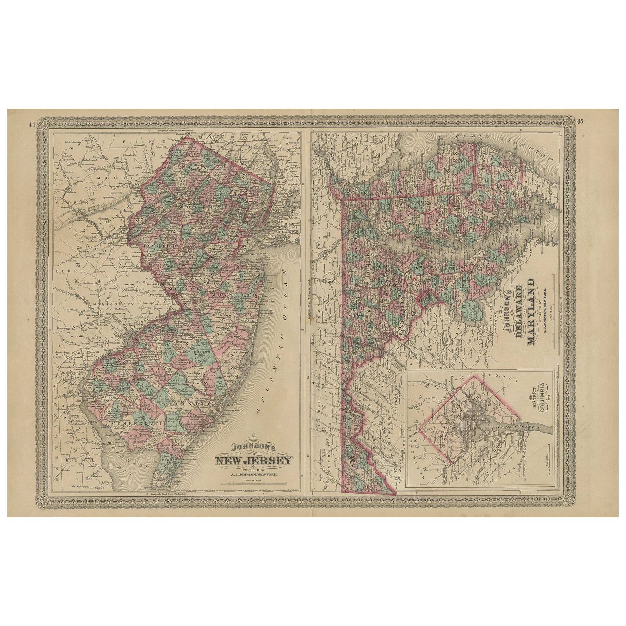
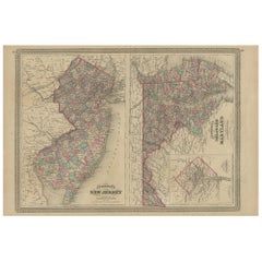
Antique Map of New Jersey, Delaware and Maryland by Johnson, 1872
Located in Langweer, NL
Antique map titled 'Johnson's New Jersey (..). Two maps on one sheet showing New Jersey, Delaware and Maryland. With inset map of the district of Columbia...
Category
Antique Late 19th Century Maps
Materials
Paper
$286 Sale Price
20% Off
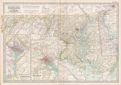
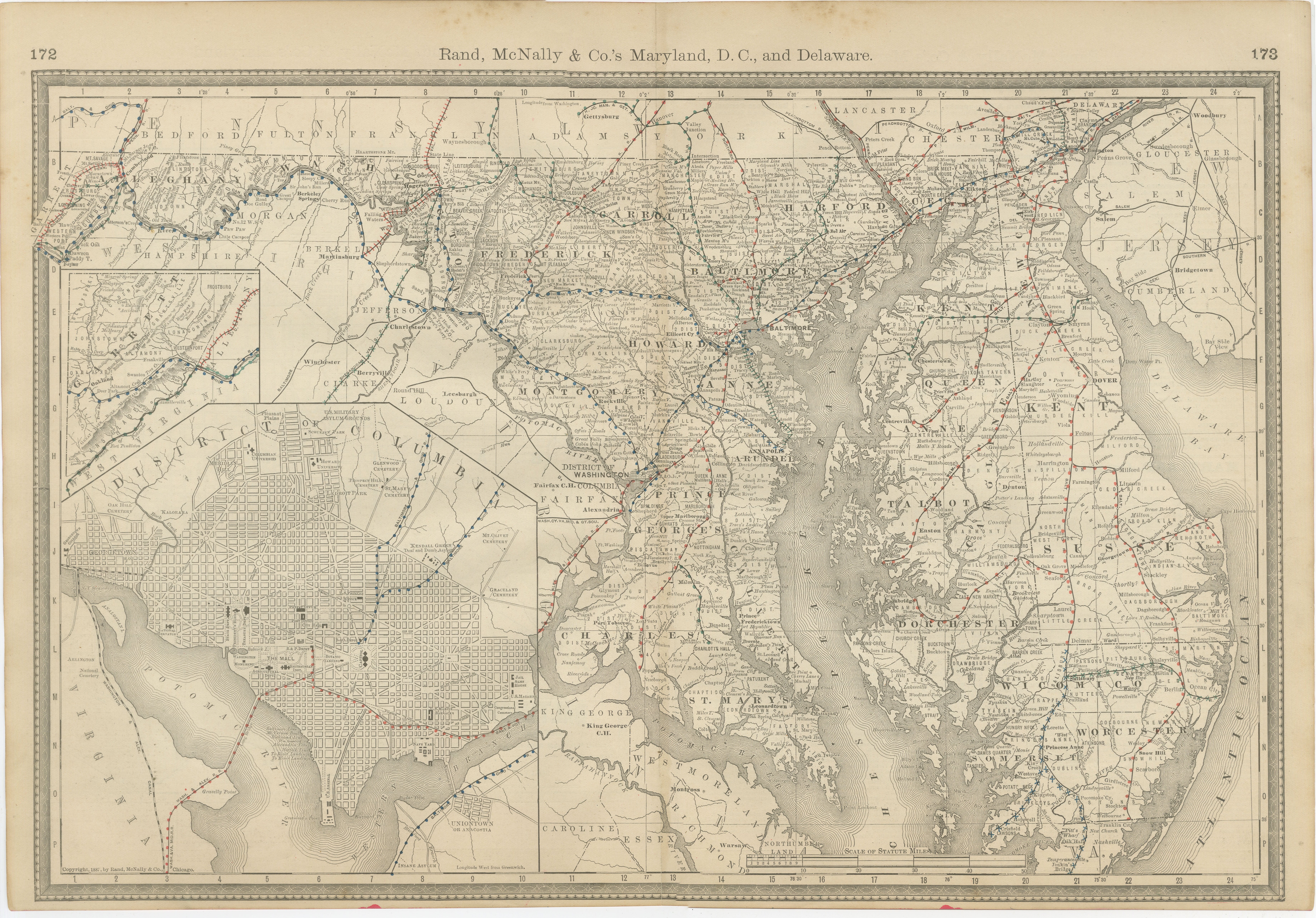
Maryland, D.C. & Delaware Antique Map – Old Line State Railroads, c.1888
Located in Langweer, NL
Antique Map of Maryland, Delaware & Washington D.C. – Rand McNally, circa 1888
This antique map of Maryland, Delaware, and Washington, D.C., was published by Rand, McNally & Co. aro...
Category
Antique Late 19th Century American Maps
Materials
Paper
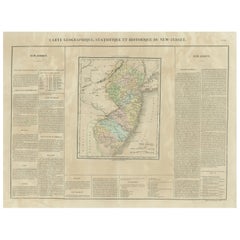
Original Antique Map of the State of New Jersey Published in France
Located in Langweer, NL
Original antique map titled 'Carte Géographique Statistique et Historique du New-Jersey'. One of the earliest obtainable maps of the State of New Jersey published outside of the Unit...
Category
Antique Early 19th Century Maps
Materials
Paper
$190 Sale Price
20% Off
Antique Map of Pennsylvania and New Jersey by Johnson, 1872
Located in Langweer, NL
Antique map titled 'Johnson's Pennsylvania and New Jersey'. Original map showing Pennsylvania and New Jersey. This map originates from 'Johnson's New Illustrated Family Atlas of the ...
Category
Antique Late 19th Century Maps
Materials
Paper

$238 Sale Price
20% Off
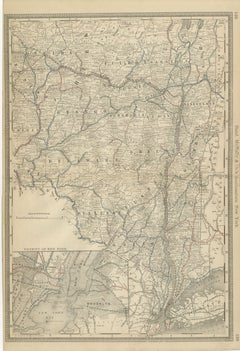
Antique Map of Southeastern New York – Rand McNally, circa 1888
Located in Langweer, NL
Antique Map of Southeastern New York – Rand McNally, circa 1888
This antique map of southeastern New York was published by Rand, McNally & Co. around 1888. It offers a detailed depi...
Category
Antique Late 19th Century American Maps
Materials
Paper
You May Also Like
Original Antique Map of the American State of New Jersey, 1903
Located in St Annes, Lancashire
Antique map of New Jersey
Published By A & C Black. 1903
Original colour
Good condition
Unframed.
Free shipping
Category
Antique Early 1900s English Maps
Materials
Paper
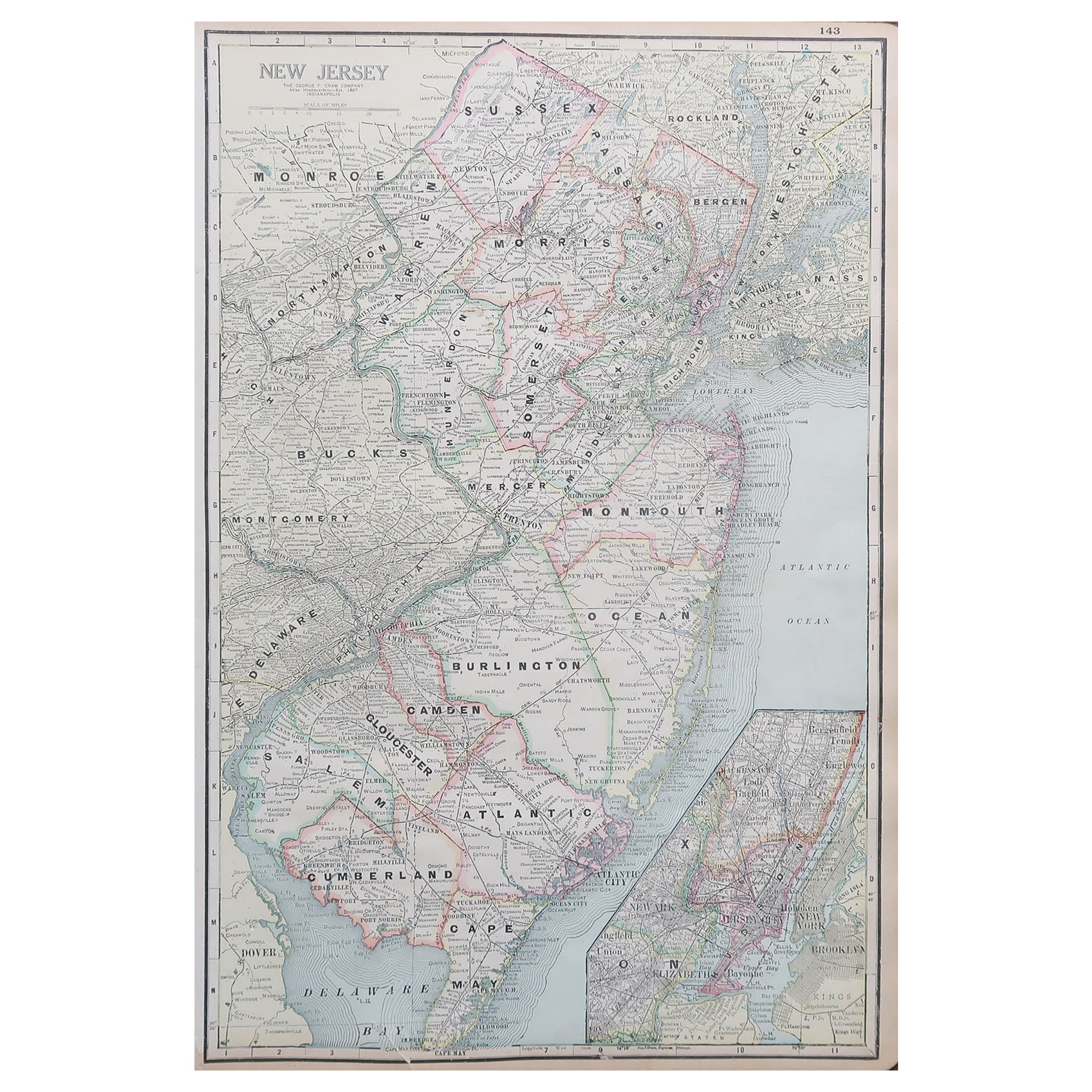
Large Original Antique Map of New Jersey, USA, circa 1900
Located in St Annes, Lancashire
Fabulous map of New Jersey
Original color
Engraved and printed by the George F. Cram Company, Indianapolis.
Published, circa 1900
Unframed
Repairs to minor edge tears
Category
Antique 1890s American Maps
Materials
Paper
New Jersey. USA Century Atlas state antique vintage map
Located in Melbourne, Victoria
'The Century Atlas. New Jersey'
Original antique map, 1903.
Central fold as issued. Map name and number printed on the reverse corners.
Sheet 40cm by 29.5cm.
Category
Early 20th Century Victorian More Prints
Materials
Lithograph
Pennsylvania, Eastern Part. USA. Century Atlas state antique vintage map
Located in Melbourne, Victoria
'The Century Atlas. Pennsylvania, Eastern Part.'
Original antique map, 1903.
Central fold as issued. Map name and number printed on the reverse corners.
Sheet 40cm by 29.5cm.
Category
Early 20th Century Victorian More Prints
Materials
Lithograph
Original Antique Map of the American State of Pennsylvania( Eastern Part ), 1903
Located in St Annes, Lancashire
Antique map of Pennsylvania ( Eastern part )
Published By A & C Black. 1903
Original colour
Good condition
Unframed.
Free shipping
Category
Antique Early 1900s English Maps
Materials
Paper

Maryland and Delaware. USA. Century Atlas state antique vintage map
Located in Melbourne, Victoria
'The Century Atlas. Maryland and Delaware.'
Original antique map, 1903.
Central fold as issued. Map name and number printed on the reverse corners.
Sheet 29.5cm by 40cm.
Category
Early 20th Century Victorian More Prints
Materials
Lithograph