Items Similar to North America Antique Railroad Map c.1888 – U.S., Canada & Mexico


Video Loading
Want more images or videos?
Request additional images or videos from the seller
1 of 11
North America Antique Railroad Map c.1888 – U.S., Canada & Mexico
$644.17
£476.24
€540
CA$886.05
A$984.90
CHF 516.26
MX$12,027.99
NOK 6,445.24
SEK 6,063.77
DKK 4,111.01
About the Item
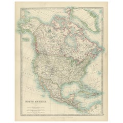
Antique Map of North America – Rand McNally, circa 1888
This antique map of North America, published by Rand, McNally & Co. circa 1888, offers a comprehensive view of the continent during a period of rapid political, territorial, and economic change. The map extends from the Arctic regions and Greenland in the north to Central America and the Caribbean in the south, with detailed coverage of the United States, Mexico, and British America (Canada).
The United States is shown with clear state boundaries, towns, and transport connections, reflecting the country’s expansion westward. Mexico is delineated by states and provinces, while Central America and the Caribbean islands are neatly engraved. Canada, labeled “British America,” covers vast territories with relatively fewer details, emphasizing the great expanse of land that was only sparsely mapped at the time. Greenland is included in the northeast, while the far north is intriguingly labeled “Unknown Region.”
Soft pastel hand-coloring distinguishes political divisions, with yellow, pink, and green shading highlighting individual states and territories. The map also features engraved coastlines, rivers, mountain ranges, and important ports. An inset map of the Aleutian Islands is included at lower left.
This sheet exemplifies Rand McNally’s late 19th-century cartography, combining precision, clarity, and attractive presentation. It reflects both the geopolitical landscape of the period and the publisher’s role in making affordable atlases widely available in America.
Condition report:
Very good condition with even toning and original hand coloring well preserved. Center fold as issued. Minor edge toning and light handling marks in the margins, not affecting the printed area.
Framing tips:
A light cream mat with a thin gilt inner border and a classic black or dark wood frame will highlight the delicate coloring and engraved detail. For a continental statement piece, consider framing alongside the companion maps of the United States, Canada, Mexico, and Cuba.
Technique: Lithograph with original hand coloring
Maker: Rand, McNally & Co., Chicago, circa 1888
- Dimensions:Height: 20.67 in (52.5 cm)Width: 14.18 in (36 cm)Depth: 0.01 in (0.2 mm)
- Materials and Techniques:Paper,Engraved
- Place of Origin:
- Period:
- Date of Manufacture:1888
- Condition:Very good condition with even toning and original hand coloring well preserved. Center fold as issued. Minor edge toning and light handling marks in the margins, not affecting the printed area.
- Seller Location:Langweer, NL
- Reference Number:Seller: BG-12794-21stDibs: LU3054346476092
About the Seller
5.0
Recognized Seller
These prestigious sellers are industry leaders and represent the highest echelon for item quality and design.
Platinum Seller
Premium sellers with a 4.7+ rating and 24-hour response times
Established in 2009
1stDibs seller since 2017
2,607 sales on 1stDibs
Typical response time: <1 hour
- ShippingRetrieving quote...Shipping from: Langweer, Netherlands
- Return Policy
Authenticity Guarantee
In the unlikely event there’s an issue with an item’s authenticity, contact us within 1 year for a full refund. DetailsMoney-Back Guarantee
If your item is not as described, is damaged in transit, or does not arrive, contact us within 7 days for a full refund. Details24-Hour Cancellation
You have a 24-hour grace period in which to reconsider your purchase, with no questions asked.Vetted Professional Sellers
Our world-class sellers must adhere to strict standards for service and quality, maintaining the integrity of our listings.Price-Match Guarantee
If you find that a seller listed the same item for a lower price elsewhere, we’ll match it.Trusted Global Delivery
Our best-in-class carrier network provides specialized shipping options worldwide, including custom delivery.More From This Seller
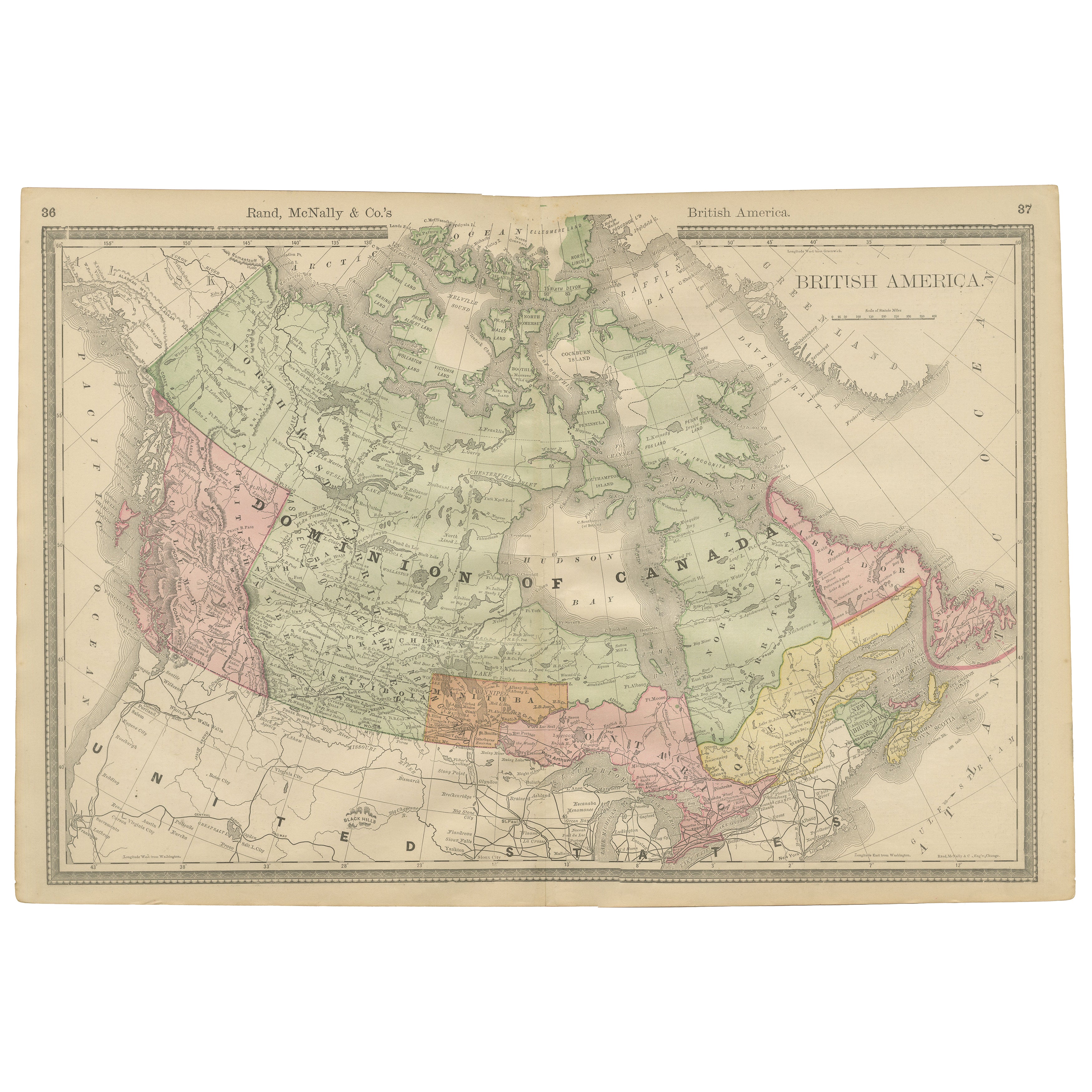
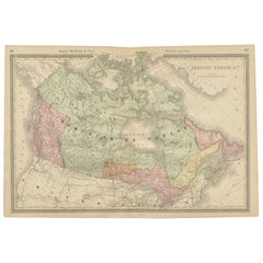
View AllCanada Antique Railroad Map c.1888 – British America, Cities & Regions
Located in Langweer, NL
Antique Map of Canada – Rand McNally’s British America, circa 1888
This antique map titled “Rand, McNally & Co.’s British America” was published around 1888 and depicts the full ext...
Category
Antique Late 19th Century American Maps
Materials
Paper
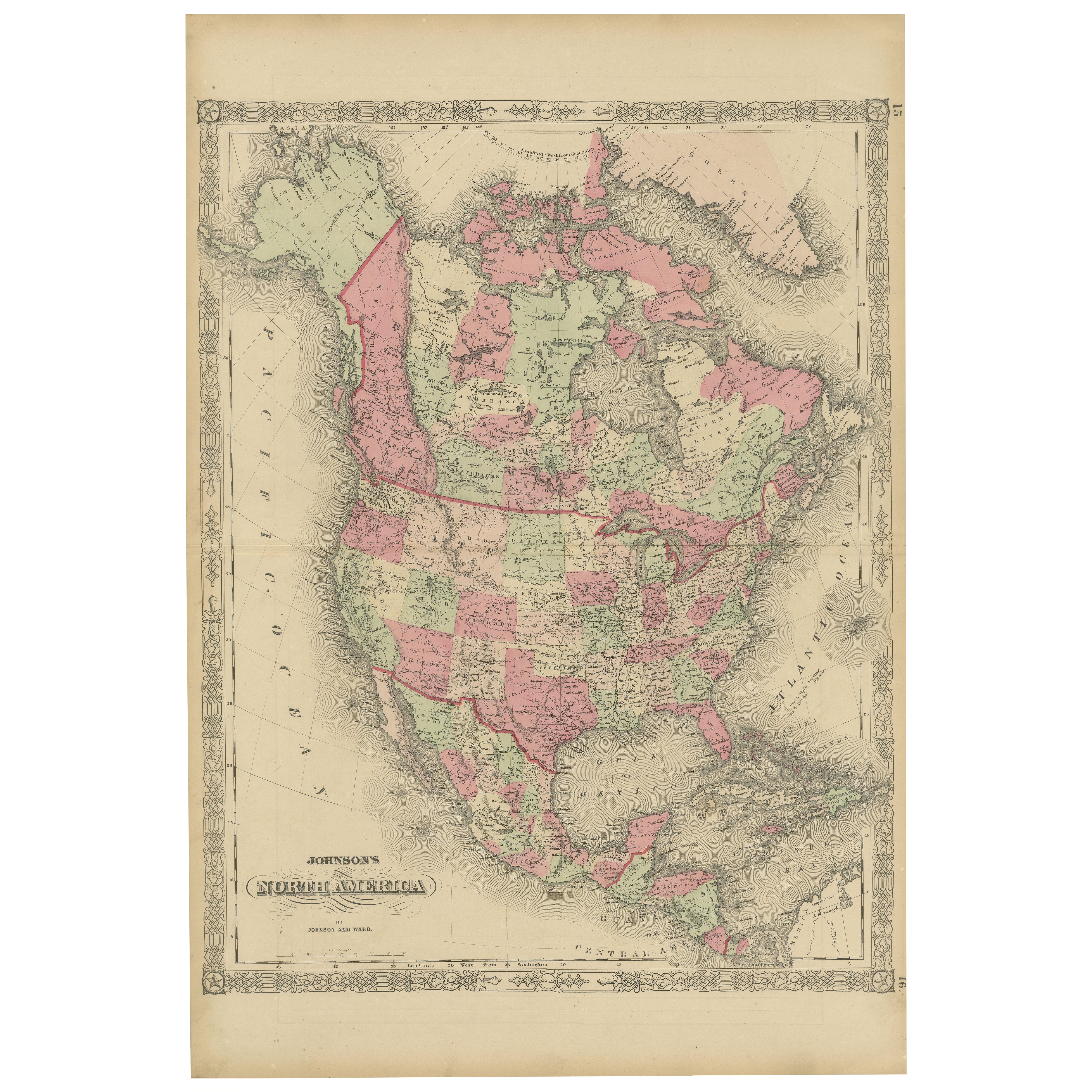
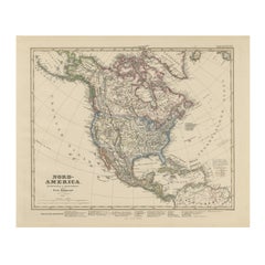
Rare 1864 Civil War Era Map of North America with Detailed Borders
Located in Langweer, NL
Title: Rare 1864 Civil War Era Map of North America with Detailed Borders
Description: This remarkable antique map, titled "Johnson's North America," was published in 1864 by Johnso...
Category
Antique 1860s Maps
Materials
Paper

Explore North America in 1903 - Intricately Detailed Antique Map
Located in Langweer, NL
North America, 1903 - A Colorful Historical Map with Detailed Borders
This attractive map of North America was engraved, printed, and published by W. & A.K. Johnston in 1903. A wond...
Category
Early 20th Century Maps
Materials
Paper
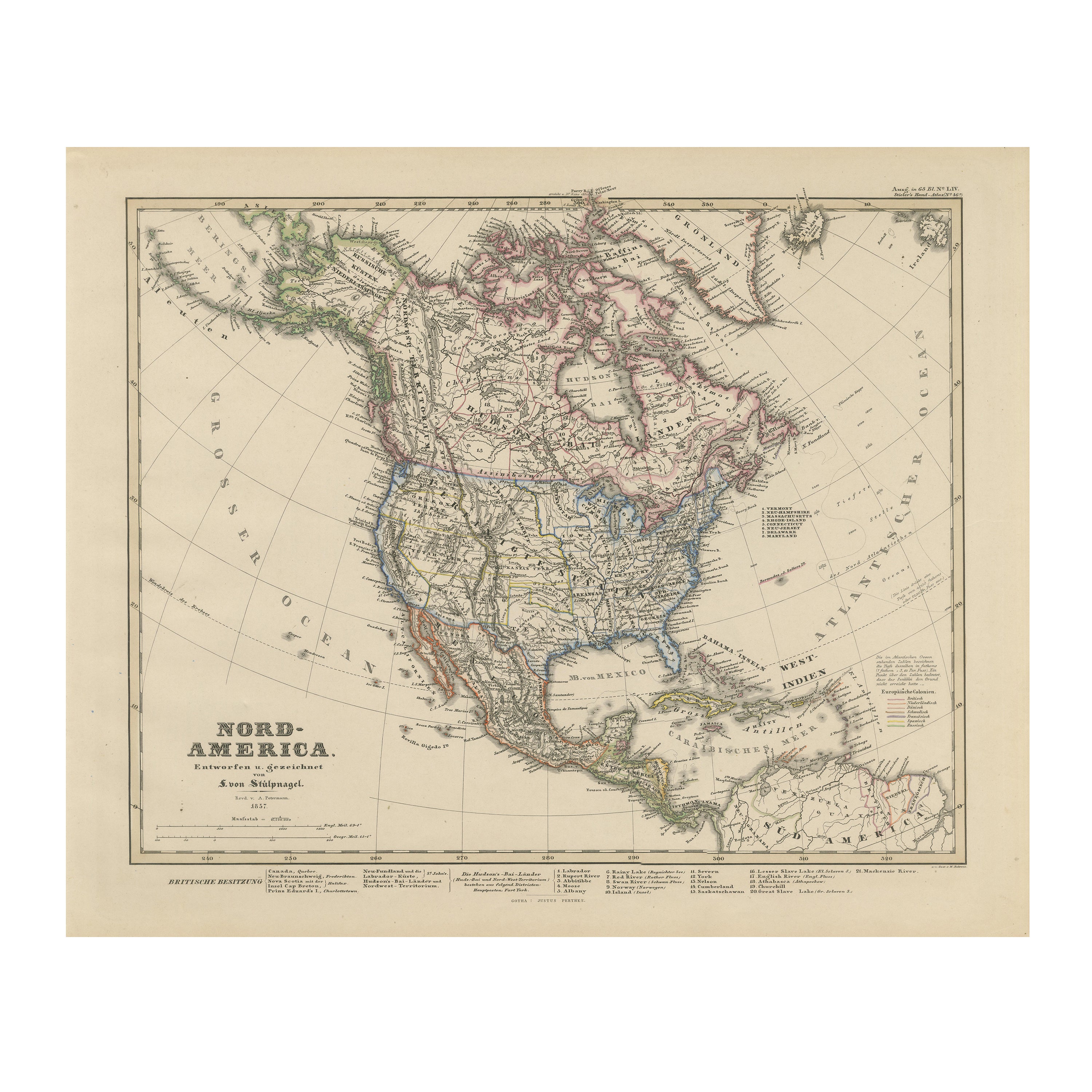
United States, Canada & Mexico – 1857 North America Map
Located in Langweer, NL
North America Map – United States, Canada, Mexico 1857
This impressive antique print shows “Nord-America” meaning “North America,” published in 1857 by Justus Perthes in Gotha as pa...
Category
Antique Mid-19th Century German Maps
Materials
Paper
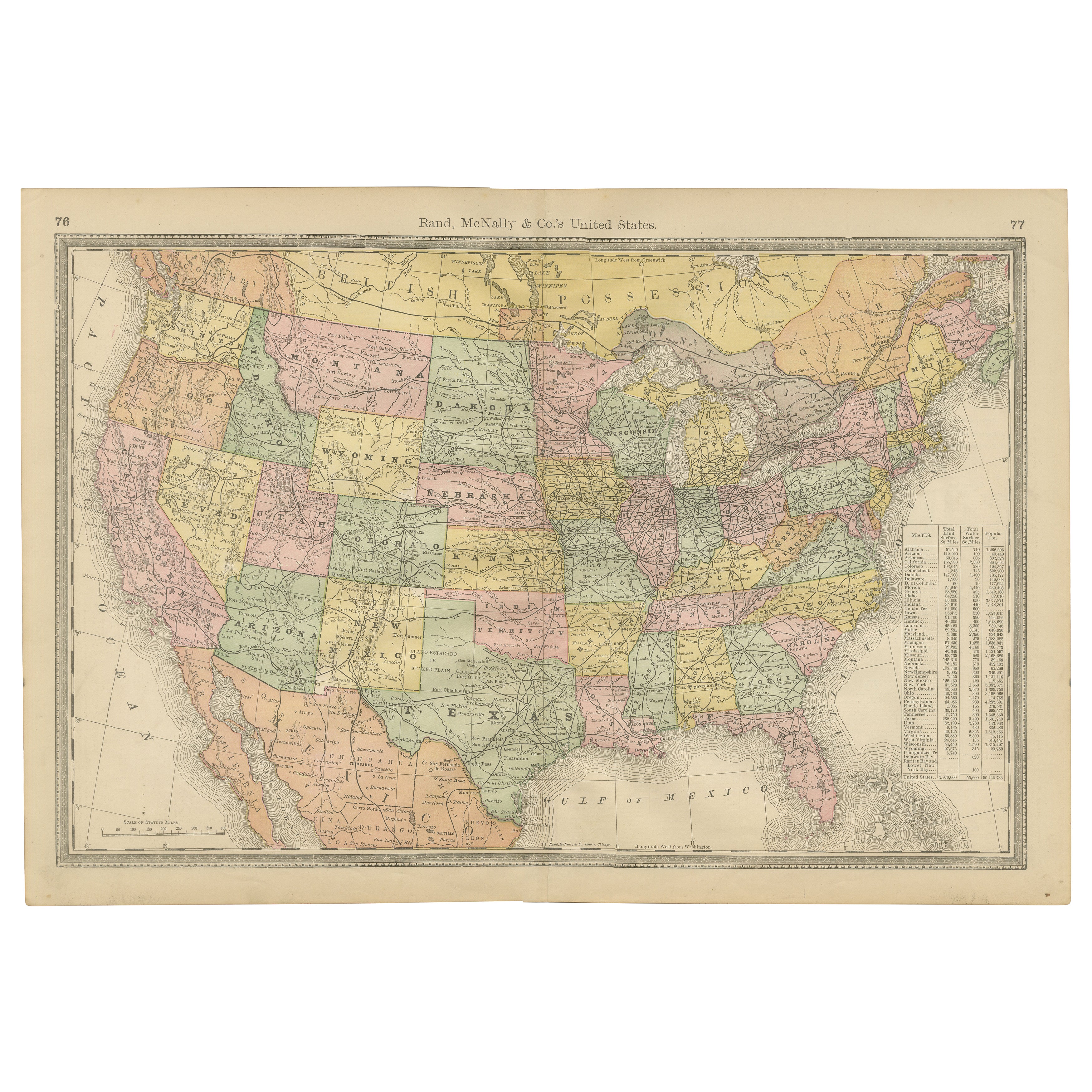
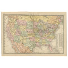
United States Antique Map c.1888 – Railroads, Territories & State Stats
Located in Langweer, NL
Antique Map of the United States – Rand McNally, circa 1888
This antique map of the United States was published by Rand, McNally & Co. around 1888. It presents a colorful overview o...
Category
Antique Late 19th Century American Maps
Materials
Paper
Antique Railroad Map of the United States by Rand, McNally & Co, 1900
Located in Langweer, NL
Antique map titled 'Rand, McNally & Co's New Official Railroad map of the United States with portions of The Dominion of Canada, The Republic of Mexico and the West Indies'. Large railroad map of the United States, sectionalised and laid on linen. Map shows state boundaries for the United States, Mexico, the West Indies, and lower portion of Canada; major cities and towns, military posts, Native American reservations, and railroads; Oklahoma and "Indian Territory." Inset: "Map of Alaska...
Category
20th Century Maps
Materials
Linen, Paper

$2,236 Sale Price
25% Off
Free Shipping
You May Also Like
North America. Century Atlas antique vintage map
Located in Melbourne, Victoria
'The Century Atlas. North America'
Original antique map, 1903.
Central fold as issued. Map name and number printed on the reverse corners.
Sheet 40cm by 29.5cm.
Category
Early 20th Century Victorian More Prints
Materials
Lithograph

Large Original Vintage Map of North America, circa 1920
Located in St Annes, Lancashire
Great map of North America
Original color. Good condition
Published by Alexander Gross
Unframed.
Category
Vintage 1920s English Edwardian Maps
Materials
Paper

Original Antique Map of North America by Dower, circa 1835
Located in St Annes, Lancashire
Nice map of North America
Drawn and engraved by J.Dower
Published by Orr & Smith. C.1835
Unframed.
Free shipping
Category
Antique 1830s English Maps
Materials
Paper

Original Antique Map of The United States of America by Dower, circa 1835
Located in St Annes, Lancashire
Nice map of the USA
Drawn and engraved by J.Dower
Published by Orr & Smith. C.1835
Unframed.
Free shipping
Category
Antique 1830s English Maps
Materials
Paper

Manitoba, British Columbia and NW Territories, Canada. Century Atlas antique map
Located in Melbourne, Victoria
'The Century Atlas. Manitoba, British Columbia and the Northwest Territories, Canada, North America.'
Original antique map, 1903.
Central fold as issued. Map name and number printe...
Category
Early 20th Century Victorian More Prints
Materials
Lithograph

1864 Map of North America, Antique Hand-Colored Map, by Adolphe Hippolyte Dufour
Located in Colorado Springs, CO
Offered is a map of North America entitled Amerique du Nord from 1864. This rare, separately published wall map was produced by Adolphe Hippolyte Dufour. This map includes vibrant an...
Category
Antique 1860s French Maps
Materials
Paper
