Items Similar to Old Map of Turkey in Europe, incl Romania, Servia, Montenegro & Bulgaria, 1882
Want more images or videos?
Request additional images or videos from the seller
1 of 5
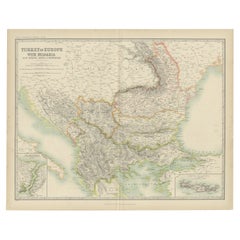
Old Map of Turkey in Europe, incl Romania, Servia, Montenegro & Bulgaria, 1882
About the Item
Antique map titled 'Turkey in Europe'.
Old map of Turkey in Europe, also depicting part of Romania, Servia, Montenegro and Bulgaria. With inset maps of the Bosphorus, Constantinople and Crete (Candia). This map originates from 'The Royal Atlas of Modern Geography, Exhibiting, in a Series of Entirely Original and Authentic Maps, the Present Condition of Geographical Discovery and Research in the Several Countries, Empires, and States of the World' by A.K. Johnston. Published by W. and A.K. Johnston, 1882.
Artists and Engravers: Alexander Keith Johnston LLD (1804-1871) was a Scottish geographer. He was a pupil of the Edinburgh engraver and mapmaker, James Kirkwood. In 1826, he joined his brother William (who would become Sir William Johnston, Lord Provost of Edinburgh) in a printing and engraving business, forming the well-known cartographical firm of W. and A. K. Johnston.
- Dimensions:Height: 19.53 in (49.6 cm)Width: 24.14 in (61.3 cm)Depth: 0 in (0.02 mm)
- Materials and Techniques:
- Period:
- Date of Manufacture:1882
- Condition:Wear consistent with age and use. Condition: Good, general age-related toning. Please study image carefully.
- Seller Location:Langweer, NL
- Reference Number:
About the Seller
5.0
Platinum Seller
These expertly vetted sellers are 1stDibs' most experienced sellers and are rated highest by our customers.
Established in 2009
1stDibs seller since 2017
1,946 sales on 1stDibs
Typical response time: <1 hour
- ShippingRetrieving quote...Ships From: Langweer, Netherlands
- Return PolicyA return for this item may be initiated within 14 days of delivery.
More From This SellerView All
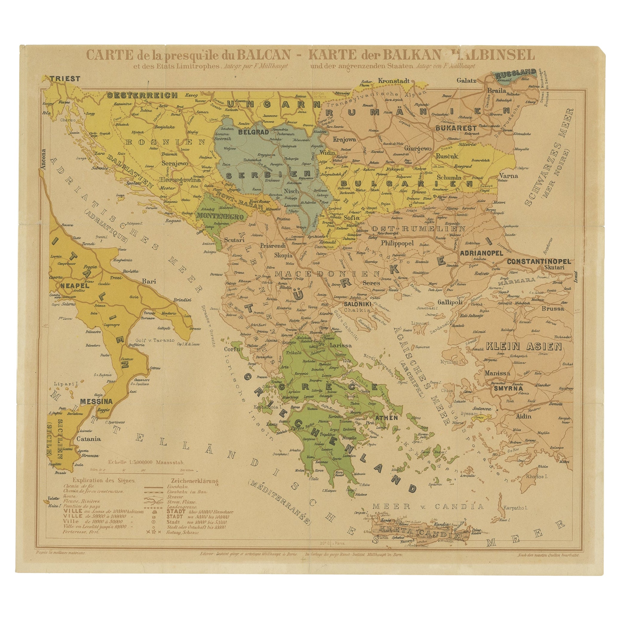
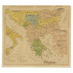
- Old Map of the Balkans Incl Greece, Turkey, Serbia, Montenegro, Bulgaria, C.1900Located in Langweer, NLAntique map titled 'Carte de la presqu-île du Balcan - Karte der Balkan Halbinsel'. Original antique map of the Balkans including Greece, Turkey, Serbia, Montenegro, Bulgaria and...Category
Antique Early 1900s Maps
MaterialsPaper
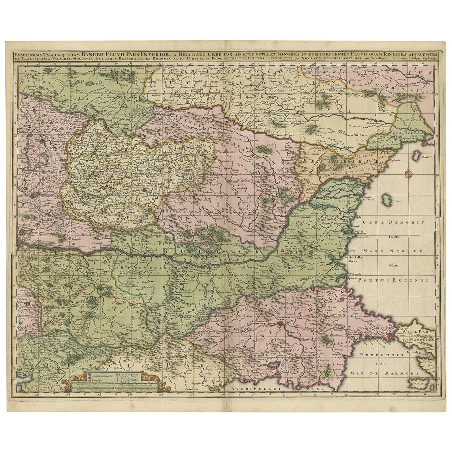
- Antique Map of Ukraine, Bulgaria, Romania, Servia & Surroundings by N. VisscherLocated in Langweer, NLAntique map titled 'Exactissima Tabula qua tam Danubii Fluvii Pars Inferior, a Belgrado Urbe usq ad ejus ostia, et minores in eum influentes, Fluvii quam Regiones adjacentes, ut Tran...Category
Antique Early 18th Century Maps
MaterialsPaper
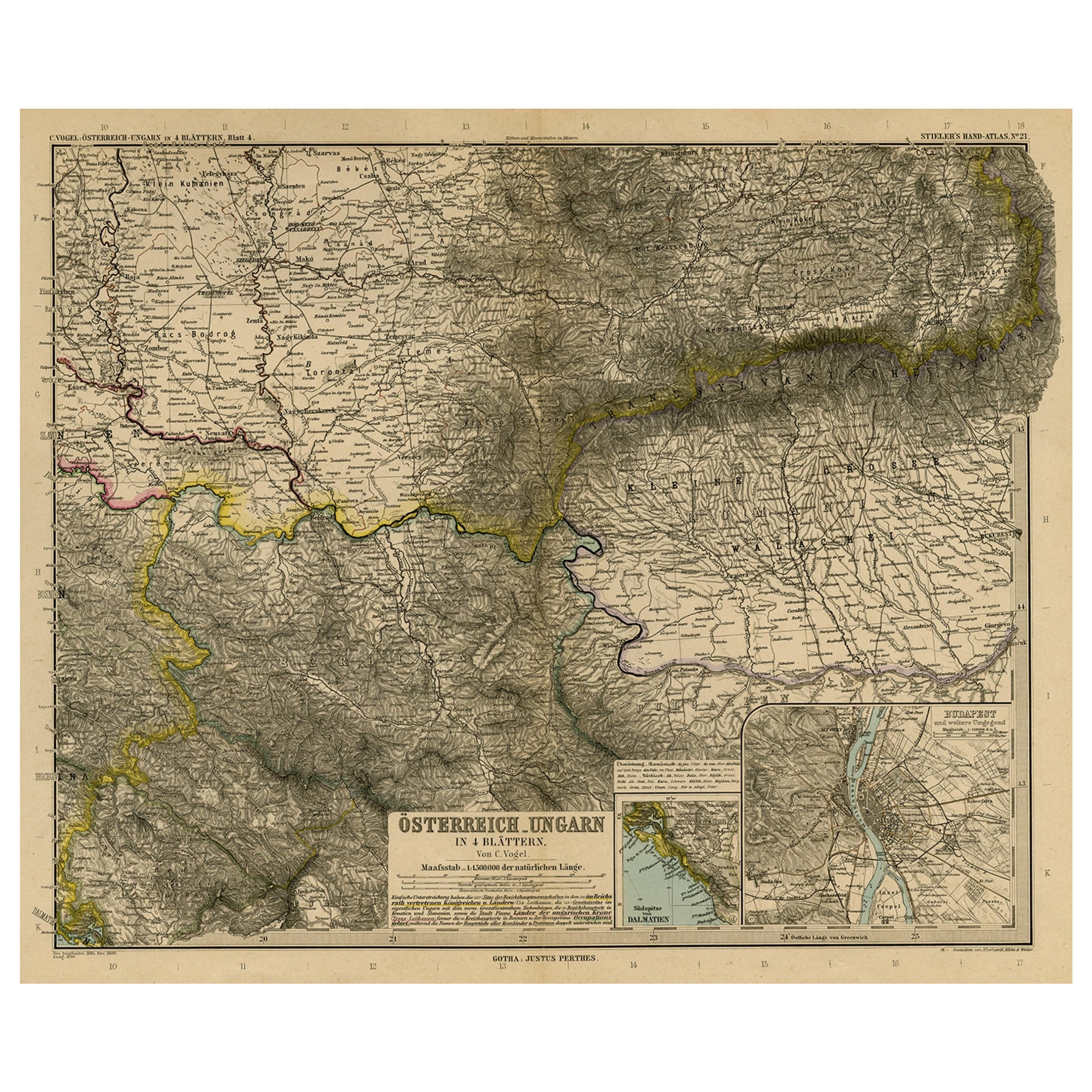
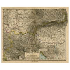
- Antique Map of Eastern Europe, Incl Montenegro & Serbia & a Budapest Map, 1890Located in Langweer, NLAntique map titled 'Osterreich-Ungarn in 4 Blattern, Blatt 4.' Map of Eastern Europe, with Montenegro in the lower left corner, the southern ...Category
Antique 1890s Maps
MaterialsPaper
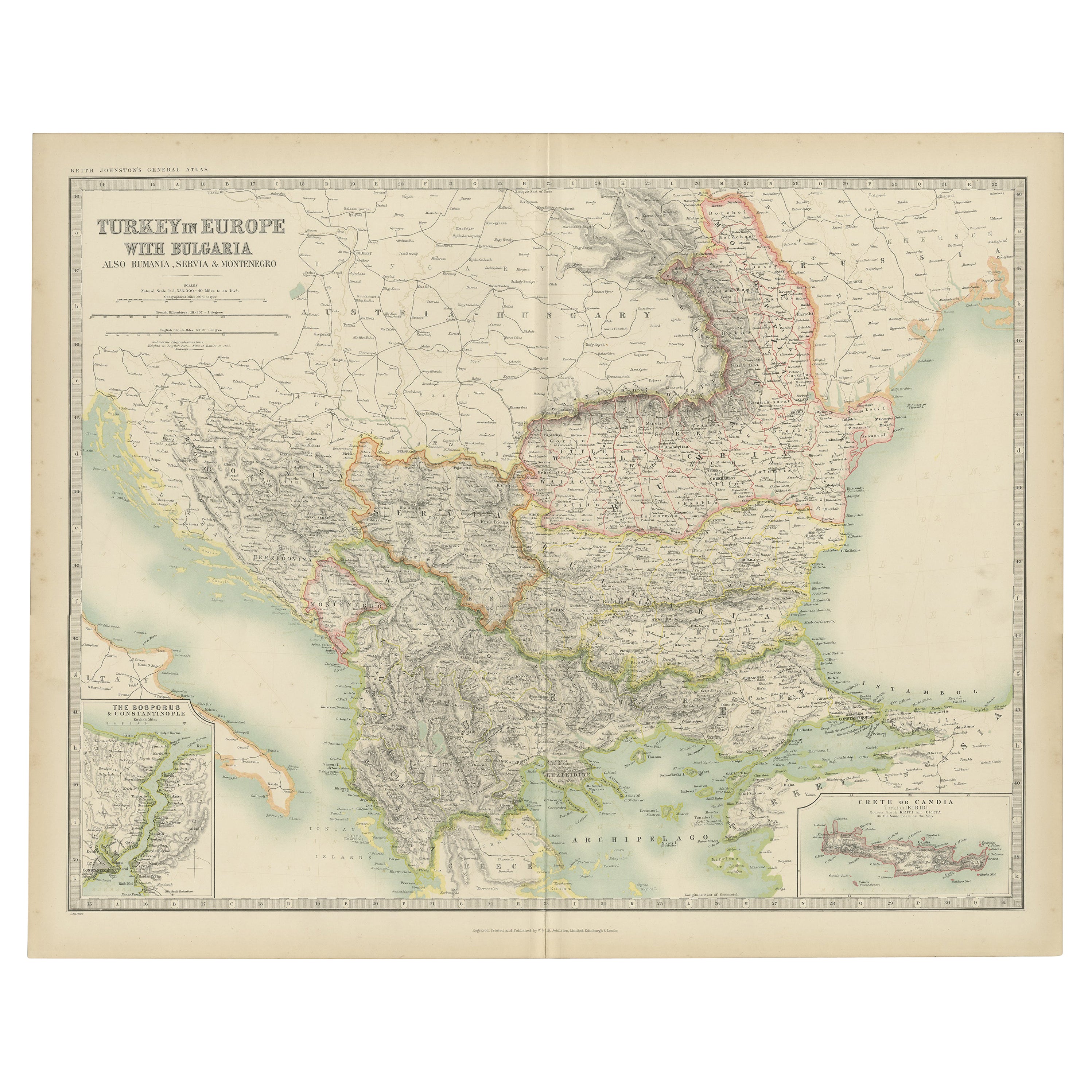
- Antique Map of Turkey in Europe with Bulgaria by Johnston '1909'Located in Langweer, NLAntique map titled 'Turkey in Europe with Bulgaria'. Original antique map of Turkey in Europe with Bulgaria. With inset maps of The Bosporus & Constantinople, and Crete (or Candia). ...Category
Early 20th Century Maps
MaterialsPaper
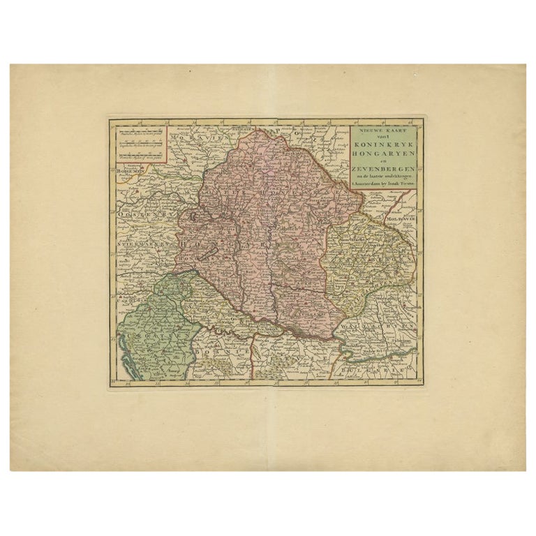
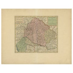
- Antique Map of Hungary Incl Surroundings like Croatia, Bosnia, Servia, 1730Located in Langweer, NLAntique map titled 'Nieuwe Kaart van t Koninkryk Hongaryen en Zevenbergen na de laatste ontdekkingen'. This map depicts Hungary including surroundings like Croatia, Bosnia, Servia,...Category
Antique 18th Century Maps
MaterialsPaper
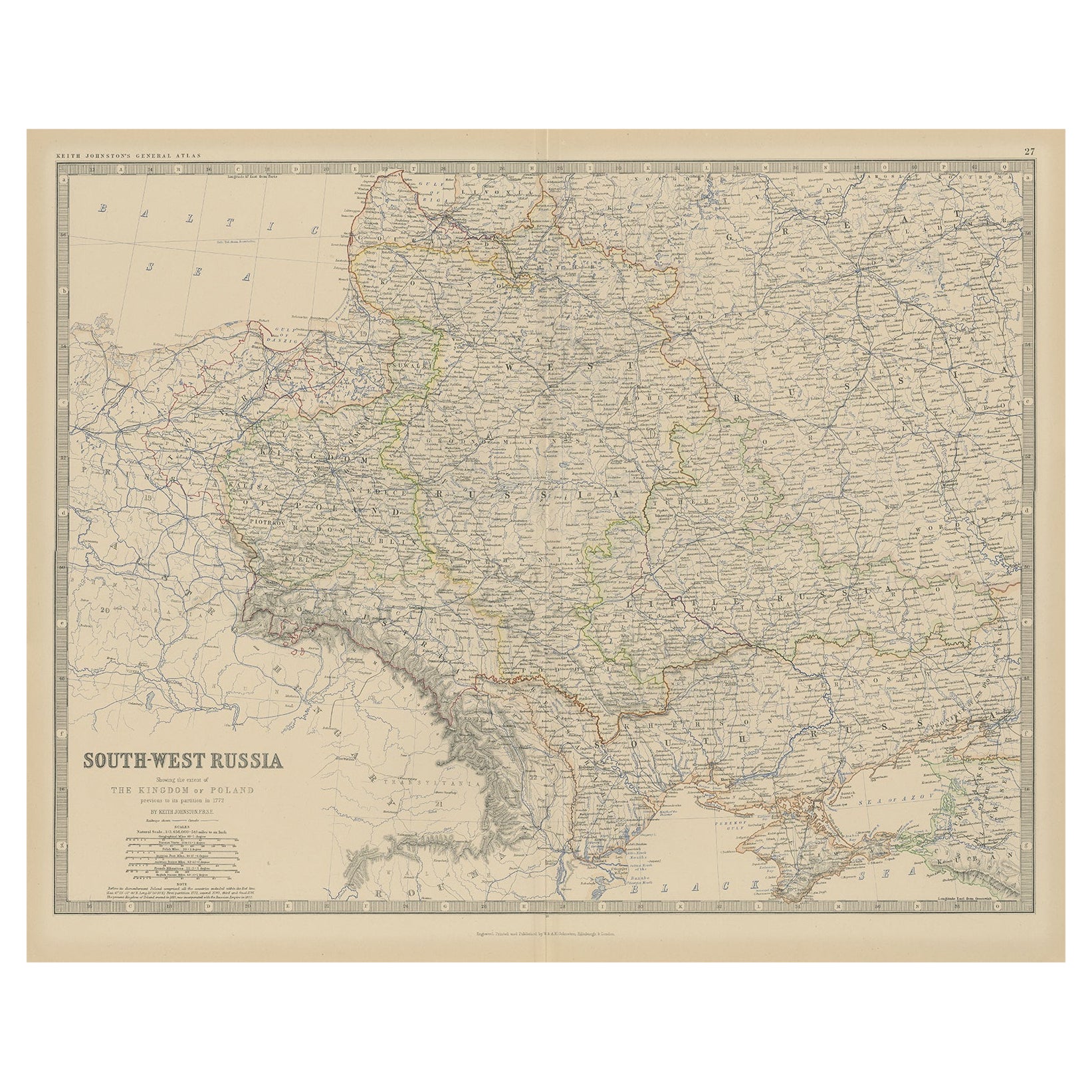
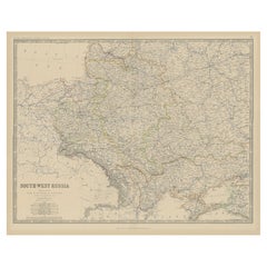
- Old Map of Southern Russia, Incl the Extent of the Kingdom of Poland, 1882Located in Langweer, NLAntique map titled 'South-West Russia'. Old map of southern Russia, also showing the extent of the Kingdom of Poland. This map originates from 'The Royal Atlas of Modern Geography...Category
Antique 1880s Maps
MaterialsPaper
You May Also Like
- Old Nautical Map of CorsicaLocated in Alessandria, PiemonteST/556/1 - Old map of Corsica isle, surveyed by Captain Hell, of the French Royal Navy in 1824, engraved and published on 1874, with additions and corre...Category
Antique Early 19th Century English Other Prints
MaterialsPaper
- Old Horizontal Map of EnglandBy TassoLocated in Alessandria, PiemonteST/520 - Old rare Italian map of England, dated 1826-1827 - by Girolamo Tasso, editor in Venise, for the atlas of M.r Le-Sage.Category
Antique Early 19th Century Italian Other Prints
MaterialsPaper
- Original Antique Map of Europe, Arrowsmith, 1820Located in St Annes, LancashireGreat map of Europe Drawn under the direction of Arrowsmith. Copper-plate engraving. Published by Longman, Hurst, Rees, Orme and Brown, 1820 ...Category
Antique 1820s English Maps
MaterialsPaper
- Scandinavia & Portions of Eastern Europe: 18th Century Hand-Colored Homann MapBy Johann Baptist HomannLocated in Alamo, CAAn early 18th century hand-colored copper-plate map entitled "Regni Sueciae in omnes suas Subjacentes Provincias accurate divisi Tabula Generalis" by Johann Baptist Homann (1663-1724...Category
Antique Early 18th Century German Maps
MaterialsPaper
- Antique Map of Principality of MonacoBy Antonio Vallardi EditoreLocated in Alessandria, PiemonteST/619 - "Old Geographical Atlas of Italy - Topographic map of ex-Principality of Monaco" - ediz Vallardi - Milano - A somewhat special edition ---Category
Antique Late 19th Century Italian Other Prints
MaterialsPaper
- Map of the Republic of GenoaLocated in New York, NYFramed antique hand-coloured map of the Republic of Genoa including the duchies of Mantua, Modena, and Parma. Europe, late 18th century. Dimension: 25...Category
Antique Late 18th Century European Maps


Recently Viewed
View AllMore Ways To Browse
Antique In Europe
Old World European
Alexander James
Bulgaria Antique
Romanian Antique Furniture
Scotland Map
Old Europe Map
Old Maps Of Europe
Antique Map Scotland
Antique Maps Scotland
Antique Scotland Map
Scotland Antique Map
Antique Scottish Maps
Romanian Artist
Map Edinburgh
Scottish Lord
Antique Map Edinburgh
Antique Map Of Edinburgh