Items Similar to Ontario Antique Map c.1888 – Western Counties, Heartland Province Railroads
Video Loading
Want more images or videos?
Request additional images or videos from the seller
1 of 15
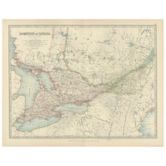
Ontario Antique Map c.1888 – Western Counties, Heartland Province Railroads
$548.74
£405.69
€460
CA$754.78
A$838.99
CHF 439.78
MX$10,246.07
NOK 5,490.39
SEK 5,165.43
DKK 3,501.97
About the Item
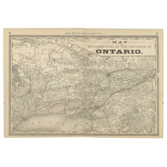
Antique Map of Western Ontario, Canada – Rand McNally, circa 1888
This antique map of western Ontario was published by Rand, McNally & Co. around 1888. Labeled “Ontario No. 1,” it presents the western portion of the province, centered on Lake Huron, Georgian Bay, and Lake Erie, with towns, counties, and railroads shown in fine detail.
The map spans from Windsor and Detroit in the southwest to the Muskoka region in the north, and across to the shores of Georgian Bay and Lake Ontario. Major cities such as Toronto, Hamilton, London, and Windsor are marked, alongside numerous smaller towns and villages that formed the growing communities of Ontario during the late 19th century.
Railroads, shown in red and blue, dominate the landscape, extending from Detroit and Buffalo through Toronto and Hamilton, and connecting the region to both the U.S. and eastern Canada. These lines illustrate the industrial and agricultural development of western Ontario, positioning it as one of Canada’s most vital economic hubs.
Lakes Erie, Huron, and Ontario are carefully engraved with wave patterns, enhancing the decorative quality of the map. The Muskoka region, popularized in the 19th century as a resort and cottage destination, is also depicted with detail, reflecting Ontario’s growing identity as both an industrial and leisure province.
As one half of the two-part Rand McNally series of Ontario, this map pairs with “Ontario No. 2” (eastern section) to provide complete coverage of the province.
Condition report:
Very good condition with light toning and mild darkening along the original center fold. Plate mark visible. Margins clean with minimal handling wear. Strong impression with crisp detail.
Framing tips:
This map is ideal for display alongside its companion, “Ontario No. 2.” When framed as a pair, they provide a complete view of Ontario. A walnut or black frame with cream matting will highlight the engraved lakes, while a muted blue inner mat will emphasize the waterways.
Technique: Lithograph with original outline color
Maker: Rand, McNally & Co., Chicago, circa 1888
---
- Dimensions:Height: 20.67 in (52.5 cm)Width: 14.18 in (36 cm)Depth: 0.01 in (0.2 mm)
- Materials and Techniques:Paper,Engraved
- Place of Origin:
- Period:
- Date of Manufacture:1888
- Condition:Very good condition with light toning and mild darkening along the original center fold. Plate mark visible. Margins clean with minimal handling wear. Strong impression with crisp detail.
- Seller Location:Langweer, NL
- Reference Number:Seller: BG-12794-91stDibs: LU3054346475852
About the Seller
5.0
Recognized Seller
These prestigious sellers are industry leaders and represent the highest echelon for item quality and design.
Platinum Seller
Premium sellers with a 4.7+ rating and 24-hour response times
Established in 2009
1stDibs seller since 2017
2,604 sales on 1stDibs
Typical response time: <1 hour
- ShippingRetrieving quote...Shipping from: Langweer, Netherlands
- Return Policy
Authenticity Guarantee
In the unlikely event there’s an issue with an item’s authenticity, contact us within 1 year for a full refund. DetailsMoney-Back Guarantee
If your item is not as described, is damaged in transit, or does not arrive, contact us within 7 days for a full refund. Details24-Hour Cancellation
You have a 24-hour grace period in which to reconsider your purchase, with no questions asked.Vetted Professional Sellers
Our world-class sellers must adhere to strict standards for service and quality, maintaining the integrity of our listings.Price-Match Guarantee
If you find that a seller listed the same item for a lower price elsewhere, we’ll match it.Trusted Global Delivery
Our best-in-class carrier network provides specialized shipping options worldwide, including custom delivery.More From This Seller
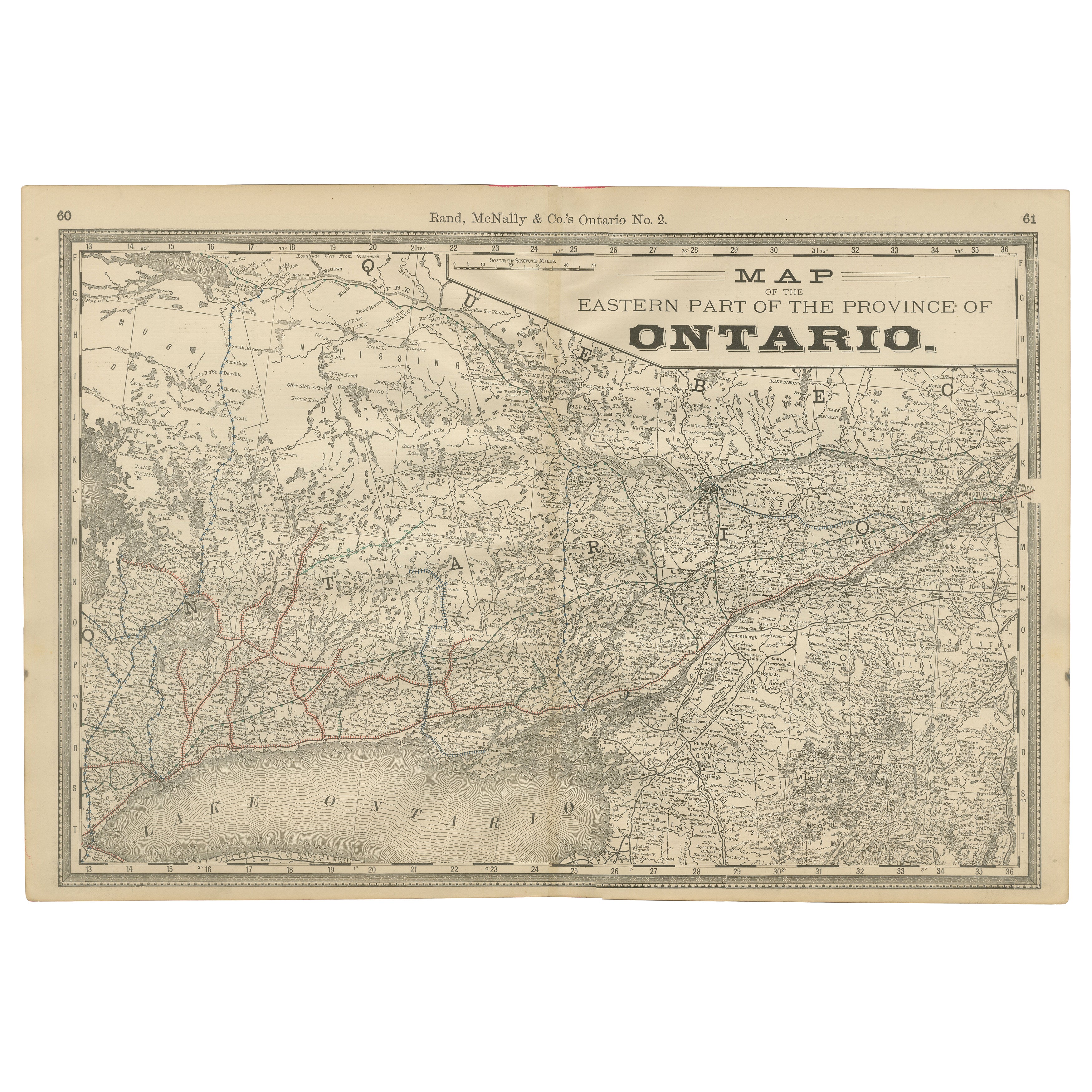
View AllEastern Ontario Antique Map c.1888 – The Heartland Province, Railroads
Located in Langweer, NL
Antique Map of Eastern Ontario, Canada – Rand McNally, circa 1888
This antique map of eastern Ontario was published by Rand, McNally & Co. around 1888. Labeled “Ontario No. 2,” it p...
Category
Antique Late 19th Century American Maps
Materials
Paper
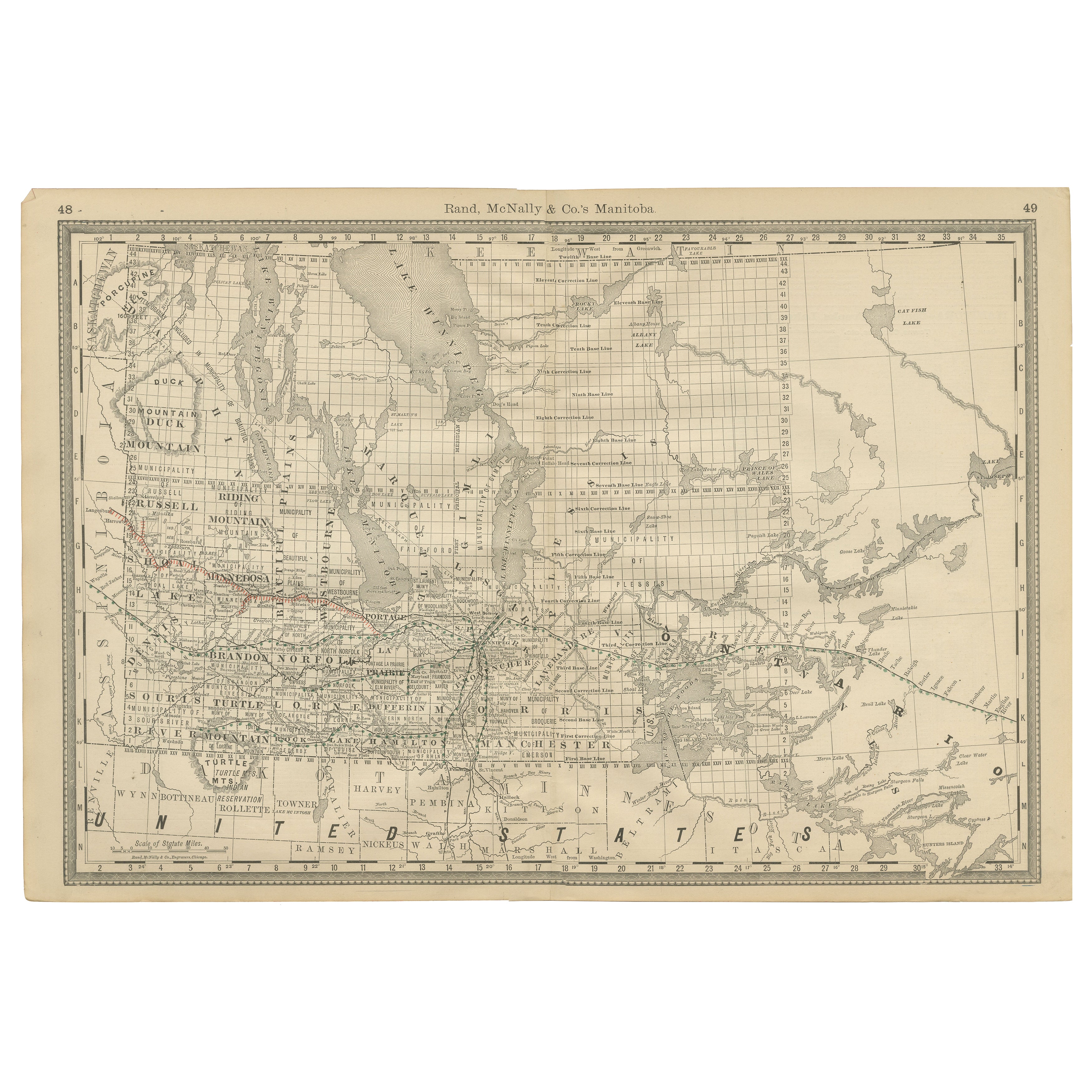
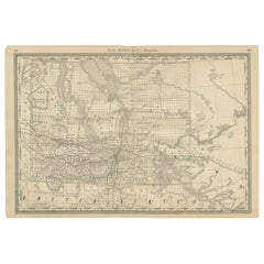
Manitoba Antique Railroad Map c.1888 – Keystone Province Cities & Towns
Located in Langweer, NL
Antique Map of Manitoba, Canada – Rand McNally, circa 1888
Description:
This antique map of Manitoba was published by Rand, McNally & Co. around 1888. It offers a detailed look at t...
Category
Antique Late 19th Century American Maps
Materials
Paper
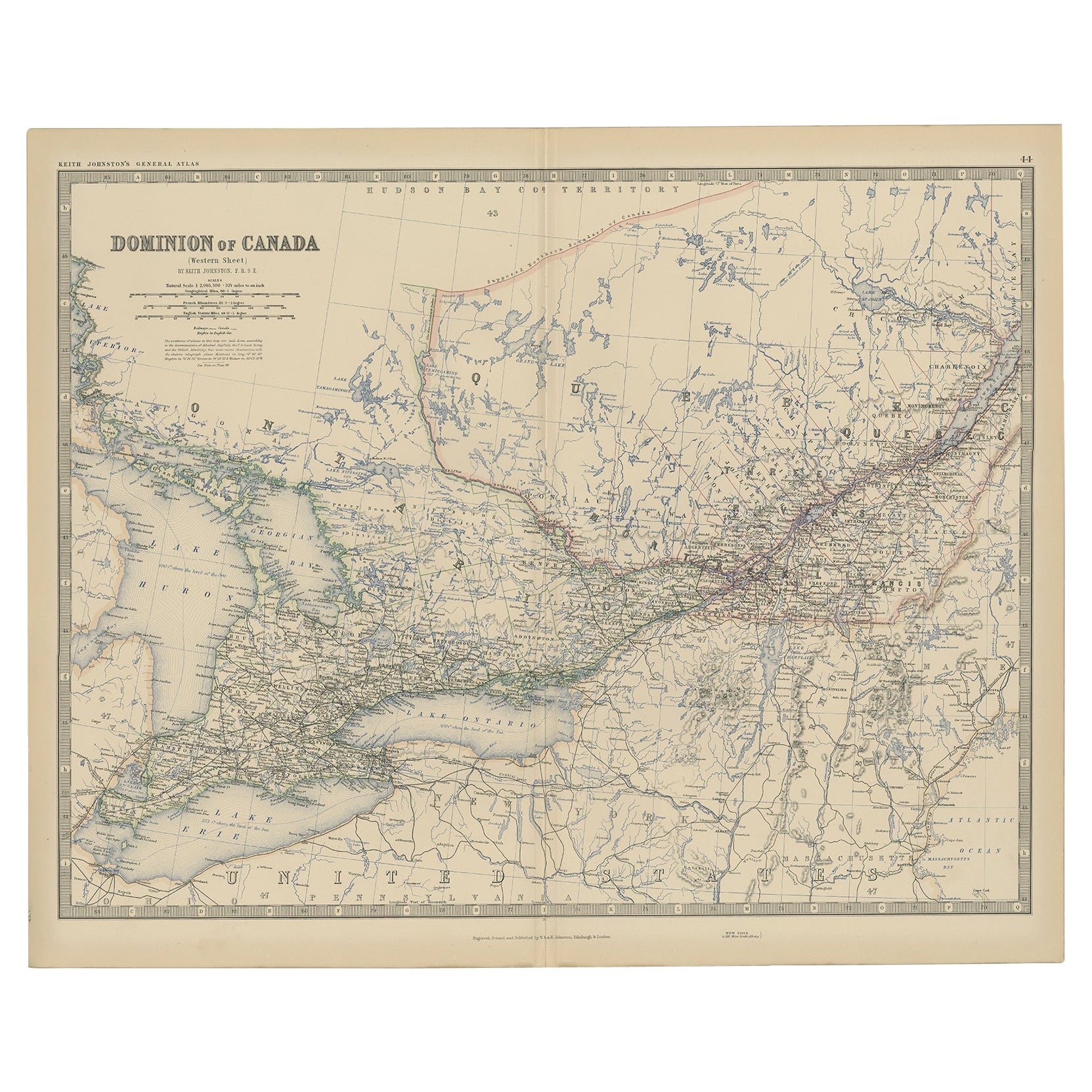
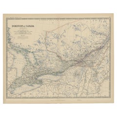
Old Original Antique Map of Western Canada, 1882
Located in Langweer, NL
Antique map titled 'Dominion of Canada'.
Old map of Western Canada. This map originates from 'The Royal Atlas of Modern Geography, Exhibiting, in a ...
Category
Antique 1880s Maps
Materials
Paper
$267 Sale Price
20% Off
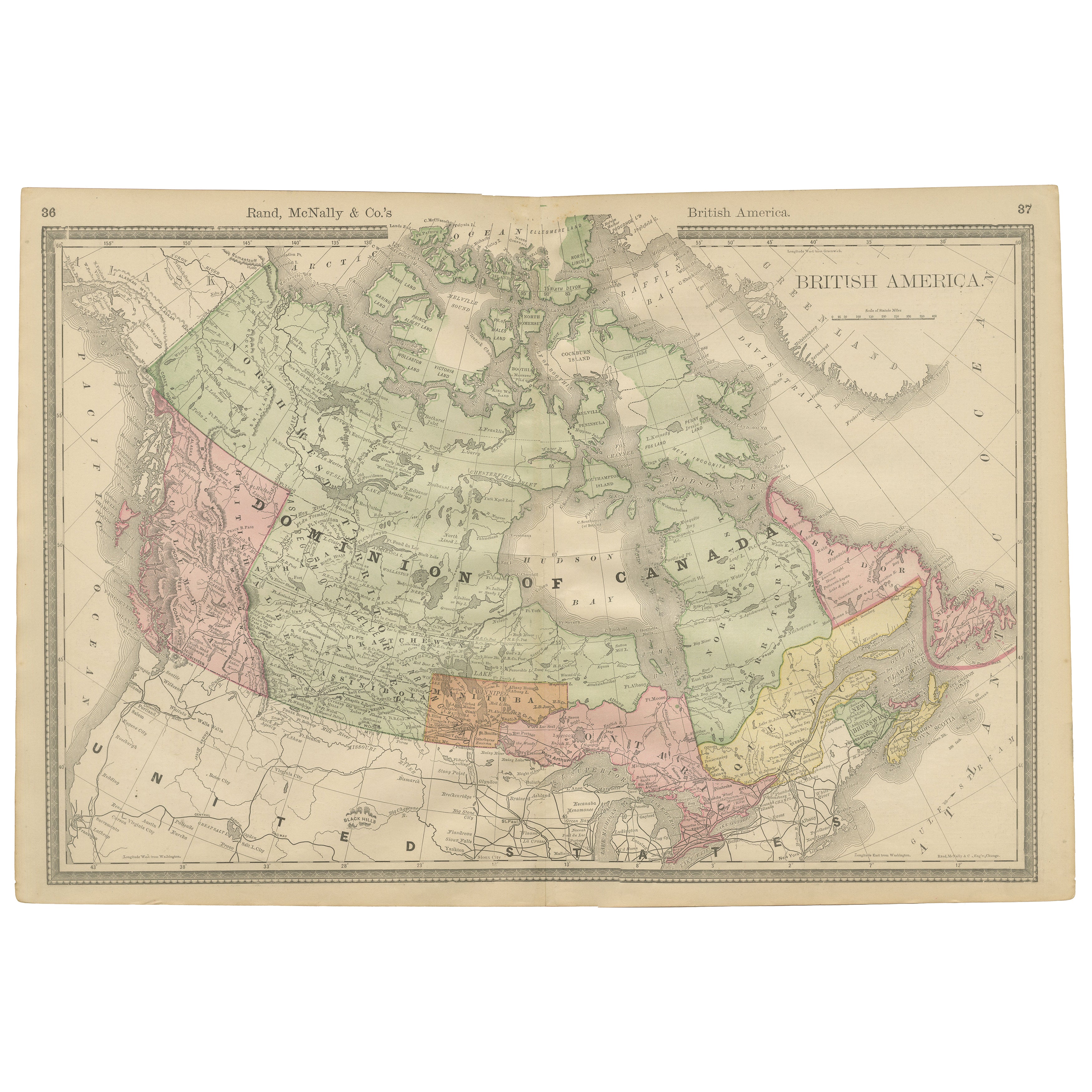
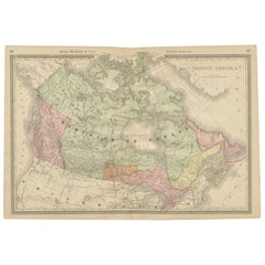
Canada Antique Railroad Map c.1888 – British America, Cities & Regions
Located in Langweer, NL
Antique Map of Canada – Rand McNally’s British America, circa 1888
This antique map titled “Rand, McNally & Co.’s British America” was published around 1888 and depicts the full ext...
Category
Antique Late 19th Century American Maps
Materials
Paper
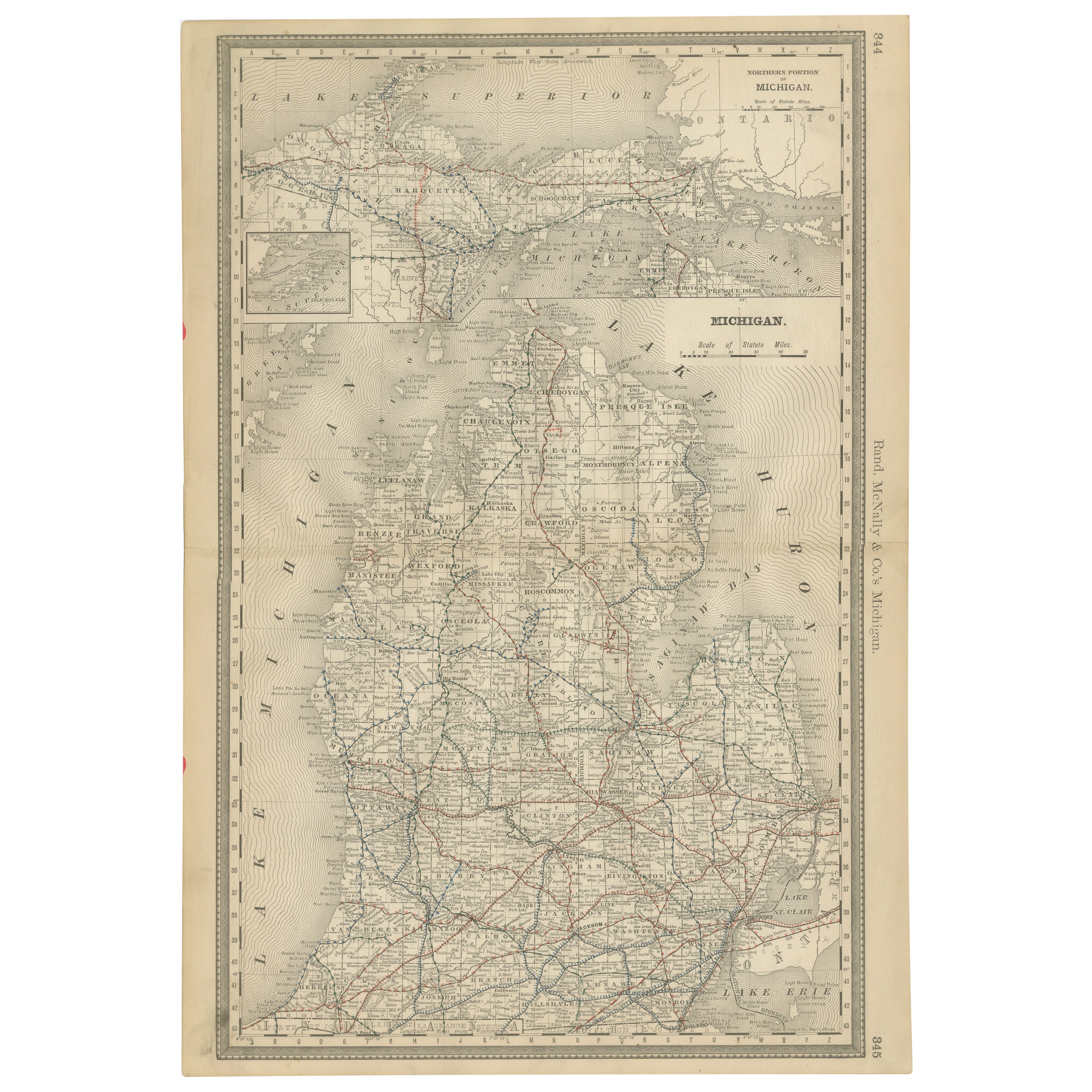
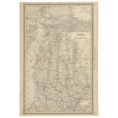
Antique Map of Michigan – The Wolverine State with Railroads & Counties, 1888
Located in Langweer, NL
Antique Map of Michigan – The Wolverine State with Railroads & Counties, 1888
This antique engraved map of Michigan, published in 1888 by Rand, McNally & Co. in Chicago for their Im...
Category
Antique Late 19th Century American Maps
Materials
Paper
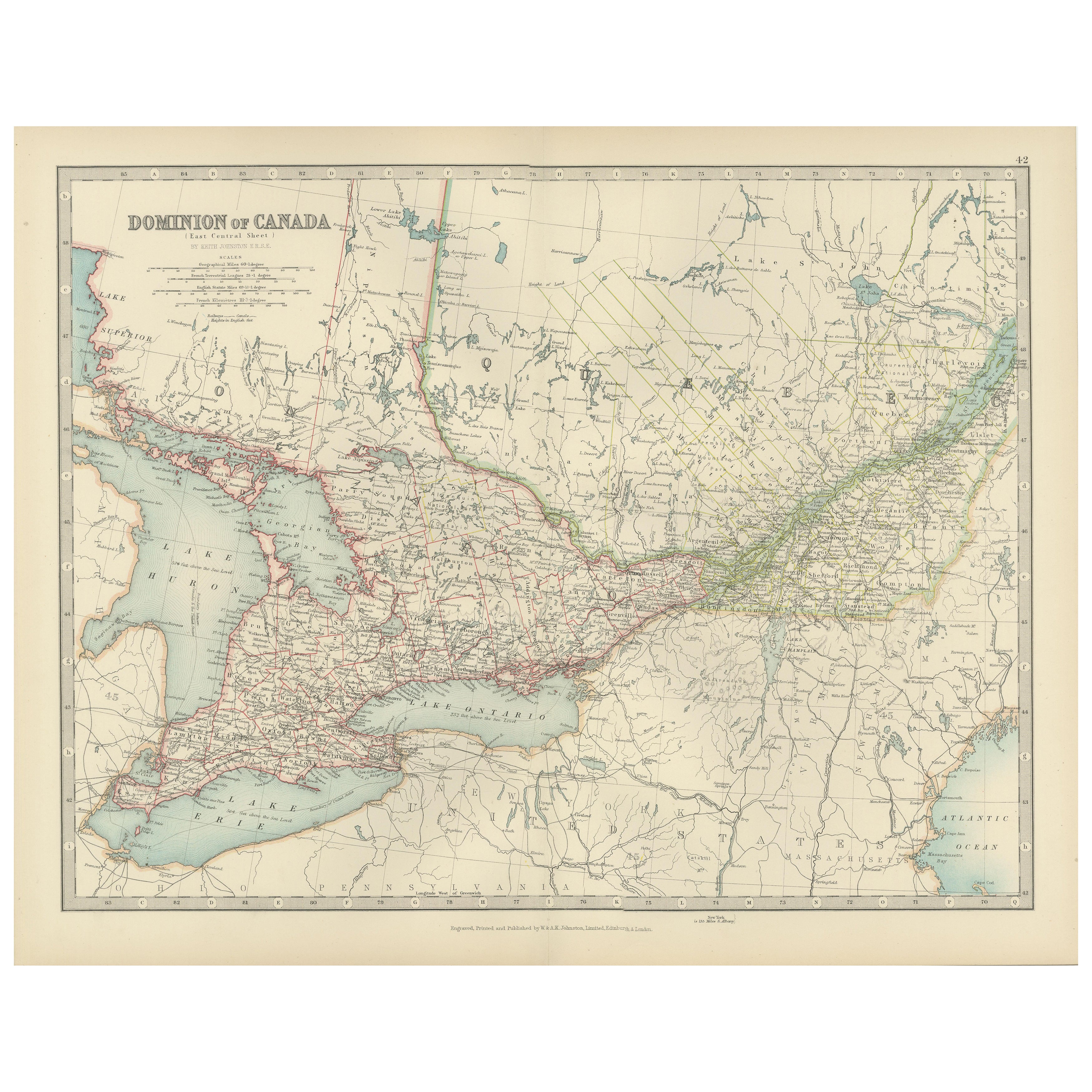
Canada Map 1903 - East Central Dominion - Ontario, Quebec & More
Located in Langweer, NL
Canada Map 1903 - East Central Dominion - Ontario, Quebec & More
This captivating antique map, titled "Dominion of Canada (East Central Sheet)" and published in 1903 by Keith Johnst...
Category
Early 20th Century Maps
Materials
Paper
You May Also Like
Quebec. Canada. Century Atlas antique vintage map
Located in Melbourne, Victoria
'The Century Atlas. Quebec'
Original antique map, 1903.
Inset maps 'Sketch Map of Quebec', Quebec and Vicinity; and 'Montreal and Vicinity'.
Central fo...
Category
Early 20th Century Victorian More Prints
Materials
Lithograph

Manitoba, British Columbia and NW Territories, Canada. Century Atlas antique map
Located in Melbourne, Victoria
'The Century Atlas. Manitoba, British Columbia and the Northwest Territories, Canada, North America.'
Original antique map, 1903.
Central fold as issued. Map name and number printe...
Category
Early 20th Century Victorian More Prints
Materials
Lithograph

Original Antique Map of the American State of Michigan ( Northern Part ), 1903
Located in St Annes, Lancashire
Antique map of Michigan ( Northern part )
Published By A & C Black. 1903
Original colour
Good condition
Unframed.
Free shipping
Category
Antique Early 1900s English Maps
Materials
Paper

Canada and Newfoundland. Century Atlas antique vintage map
Located in Melbourne, Victoria
'The Century Atlas. Dominion of Canada and Newfoundland.'
Original antique map, 1903.
Central fold as issued. Map name and number printed on the reverse corners.
Sheet 29.5cm by 40...
Category
Early 20th Century Victorian More Prints
Materials
Lithograph

Original Antique Map of New Brunswick and Nova Scotia, 1889
Located in St Annes, Lancashire
Great map of New Brunswick and Nova Scotia
Drawn and Engraved by W. & A.K. Johnston
Published By A & C Black, Edinburgh.
Original colour
Unfr...
Category
Antique 1880s Scottish Victorian Maps
Materials
Paper

North America. Century Atlas antique vintage map
Located in Melbourne, Victoria
'The Century Atlas. North America'
Original antique map, 1903.
Central fold as issued. Map name and number printed on the reverse corners.
Sheet 40cm by 29.5cm.
Category
Early 20th Century Victorian More Prints
Materials
Lithograph
