Items Similar to Original Antique Map of Canaan, Armenia, Syria, Mesopotamia and Arabia, 1709


Want more images or videos?
Request additional images or videos from the seller
1 of 6
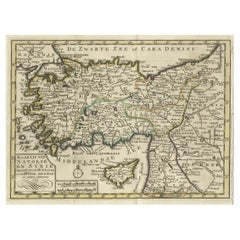
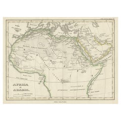
Original Antique Map of Canaan, Armenia, Syria, Mesopotamia and Arabia, 1709
About the Item
Antique map titled 'Descriptio Paradisi et Terrae Canaan'.
Original antique map of Canaan, Armenia, Syria, Mesopotamia and Arabia. It displays the Middle East from the eastern Mediterranean Sea to the Persian Gulf. The Garden of Eden is located in present-day Iraq, near the city of Babylon and Mons Ararat in the upper right corner is noted as the site of Noah's Ark. Abraham's journey from Ur is traced and numerous other biblical places are noted. The title cartouche features the serpent in the apple tree. Published circa 1709.
Artists and Engravers: Published by F. Halma, Leeuwarden.
Condition: Good, general age-related toning. Original folding lines. Minor wear and soiling, blank verso. Please study image carefully.
- Dimensions:Height: 9.85 in (25 cm)Width: 14.89 in (37.8 cm)Depth: 0 in (0.02 mm)
- Materials and Techniques:
- Period:1700-1709
- Date of Manufacture:circa 1709
- Condition:Condition: Good, general age-related toning. Original folding lines. Minor wear and soiling, blank verso. Please study image carefully.
- Seller Location:Langweer, NL
- Reference Number:Seller: PCT-62023 1stDibs: LU3054326448842
About the Seller
5.0
Platinum Seller
These expertly vetted sellers are 1stDibs' most experienced sellers and are rated highest by our customers.
Established in 2009
1stDibs seller since 2017
1,928 sales on 1stDibs
Typical response time: <1 hour
- ShippingRetrieving quote...Ships From: Langweer, Netherlands
- Return PolicyA return for this item may be initiated within 14 days of delivery.
Auctions on 1stDibs
Our timed auctions are an opportunity to bid on extraordinary design. We do not charge a Buyer's Premium and shipping is facilitated by 1stDibs and/or the seller. Plus, all auction purchases are covered by our comprehensive Buyer Protection. Learn More
More From This SellerView All
- Antique Map of Syria and Arabia Petraea by Lowry '1852'Located in Langweer, NLAntique map titled 'Syria and Arabia Petraea'. Two individual sheets of Syria and Arabia Petraea. This map originates from 'Lowry's Table Atlas constructed and engraved from the most...Category
Antique Mid-19th Century Maps
MaterialsPaper
- Original Antique Map of Arabia and the Red SeaLocated in Langweer, NLAntique map titled 'Carte de la Coste d'Arabie (..) - Kaart van de Kust van Arabië (..)'. This is a Dutch version, engraved by J. van Schley, of Bellin's map of Arabia and the Red Se...Category
Antique Mid-18th Century Maps
MaterialsPaper
- Old Map of Anatolia, part of modern-day Turkey, Armenia and Syria, 1745Located in Langweer, NLTitle: "Kaartje van Natolie en Syrie opgesteld door de Hr. Lucas en de Hr. Guil de L'Isle en andere auteuren" The title "Kaartje van Natolie en Syrie opgesteld door de Hr. Lucas en...Category
Antique 1740s Maps
MaterialsPaper
- Old Original Map of Africa and Arabia, 1848Located in Langweer, NLAntique map titled 'Africa et Arabia'. Old map of Africa and Arabia originating from 'Orbis Terrarum Antiquus in usum Scholarum'. Artists and Engravers: Published by Justus P...Category
Antique 1840s Maps
MaterialsPaper
- Original Antique Map of Syria Phoenice by Van Dùren '1749'Located in Langweer, NLInteresting Antique map published in Germany titled 'Neue Vorstellung von Phoenice und Syrien (..)' This map is engraved with a lot of details. It is an original antique map of Syria...Category
Antique Mid-18th Century Maps
MaterialsPaper
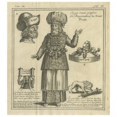
- Original Antique Engraving of A Jewish Priest, 1709Located in Langweer, NLAntique print titled 'La Representation du Grand Pontise'. Old print depicting a Jewish Priest. This print originates from 'Introduction à l'écriture sainte, où l'on traite tout ...Category
Antique Early 1700s Prints
MaterialsPaper

You May Also Like
- Map Holy Promise Land Canaan Richard Palmer Richard Blome 1687 Joseph MoxonLocated in BUNGAY, SUFFOLKCanaan comonly called the Holy Land or the Land of Promise, being the Possesion of the Israelites & travelled through by Our Lord & Saviour Iesus Christ and his Apostles. Engraven by Richard Palmer for Richard Blome. 1687 Blome, Richard, 1641-1705. London. 283 x 452 mm. Copperplate. Probably from an English Bible...Category
Antique 17th Century British Baroque Maps
MaterialsPaper
- Original Antique Map of the American State of Pennsylvania, 1889Located in St Annes, LancashireGreat map of Pennsylvania Drawn and Engraved by W. & A.K. Johnston Published By A & C Black, Edinburgh. Original colour Unframed. Repair to a minor tear on bottom edge.Category
Antique 1880s Scottish Victorian Maps
MaterialsPaper
- 1854 Map of Massachusetts, Connecticut and Rhode Island, Antique Wall MapLocated in Colorado Springs, COThis striking wall map was published in 1854 by Ensign, Bridgman & Fanning and has both full original hand-coloring and original hardware. This impression is both informative and highly decorative. The states are divided into counties, outlined in red, green, and black, and subdivided into towns. Roads, canals, and railroad lines are prominently depicted, although they are not all labeled. The mapmakers also marked lighthouses, banks, churches, and prominent buildings, with a key at right. The map is an informative and comprehensive overview of the infrastructural development of New England prior to the Civil War. Physical geographies depicted include elevation, conveyed with hachure marks, rivers and lakes. The impression features an inset map of Boston...Category
Antique 19th Century American Maps
MaterialsPaper
- Large Original Antique Folding Map of Manchester, England, Dated 1793Located in St Annes, LancashireSuperb map of Manchester and Salford Folding map. Printed on paper laid on to the original canvas Unframed. Published by C. Laurent, 1793. ...Category
Antique 1790s English Georgian Maps
MaterialsCanvas, Paper
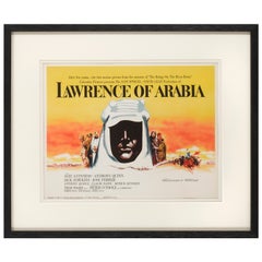
- Lawrence of ArabiaBy Saverio PavoneLocated in London, GBOriginal American Title lobby card for the films US release in 1962. This epic British film is based on the life of T. E. Lawrence. It was directed by David Lean and produced by Sam ...Category
Vintage 1960s American Posters
MaterialsPaper
- Antique Map of Principality of MonacoBy Antonio Vallardi EditoreLocated in Alessandria, PiemonteST/619 - "Old Geographical Atlas of Italy - Topographic map of ex-Principality of Monaco" - ediz Vallardi - Milano - A somewhat special edition ---Category
Antique Late 19th Century Italian Other Prints
MaterialsPaper


Recently Viewed
View AllMore Ways To Browse
Antique Syrian
Antique Syrian Furniture
Syrian Antique Furniture
Arabian Antique
Antique Armenian
Armenian Antique
Eastern Syrian
Syrian Middle Eastern
Antique Armenia
Mediterranean Garden Furniture
Middle Eastern Arabian
Mon Et
Serpent Garden
Biblical Antiques
Arabian Syrian
Near Eastern Antique
Antique Ark
Maps Of Mediterranean