Items Similar to Old Map of Anatolia, part of modern-day Turkey, Armenia and Syria, 1745


Want more images or videos?
Request additional images or videos from the seller
1 of 6
Old Map of Anatolia, part of modern-day Turkey, Armenia and Syria, 1745
About the Item
Title: "Kaartje van Natolie en Syrie opgesteld door de Hr. Lucas en de Hr. Guil de L'Isle en andere auteuren"
The title "Kaartje van Natolie en Syrie opgesteld door de Hr. Lucas en de Hr. Guil de L'Isle en andere auteuren" translates to "Map of Anatolia and Syria compiled by Mr. Lucas and Mr. Guillaume de L'Isle and other authors" in English.
This title indicates a map that depicts the regions of Anatolia (part of modern-day Turkey) and Syria, created through the collaboration of Mr. Lucas, Mr. Guillaume de L'Isle, and possibly additional authors or contributors. It suggests a map designed to display the geographical features, cities, rivers, and other significant landmarks within Anatolia and Syria based on the collective work and expertise of these cartographers and other contributors.
Published by Jacob Keizer and by Jan de Lat
Creator: Keizer, Jacob, active 1706-1750
- Dimensions:Height: 6.7 in (17 cm)Width: 9.45 in (24 cm)Depth: 0 in (0.02 mm)
- Materials and Techniques:Paper,Engraved
- Period:1740-1749
- Date of Manufacture:1745
- Condition:Very Good. Three folding lines. Tight margin on the right but image is not disturbed. Original Borderline coloring. Study the image carefully.
- Seller Location:Langweer, NL
- Reference Number:
About the Seller
5.0
Platinum Seller
These expertly vetted sellers are 1stDibs' most experienced sellers and are rated highest by our customers.
Established in 2009
1stDibs seller since 2017
1,922 sales on 1stDibs
Typical response time: <1 hour
- ShippingRetrieving quote...Ships From: Langweer, Netherlands
- Return PolicyA return for this item may be initiated within 14 days of delivery.
More From This SellerView All
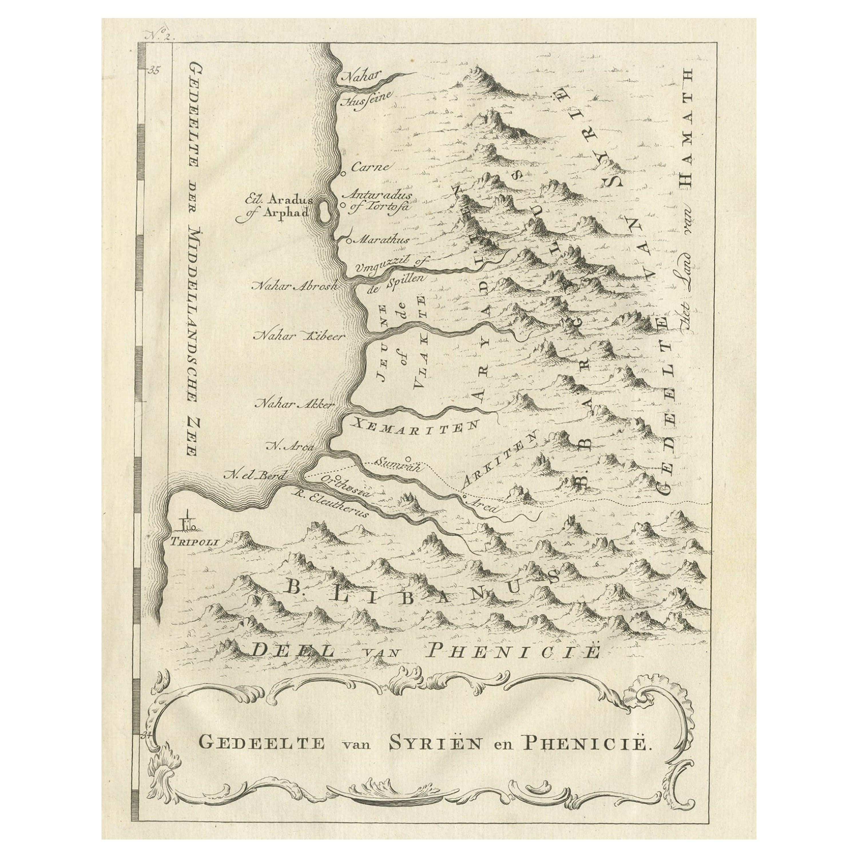
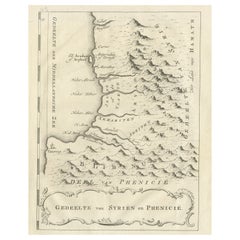
- Old Dutch Map of Part of Syria and Phoenicia, 1773Located in Langweer, NLAntique print titled 'Gedeelte van Syriën en Phenicië'. Old map of part of Syria and Phoenicia. Originates from the first Dutch editon of an interesting travel account of Norther...Category
Antique 1770s Maps
MaterialsPaper
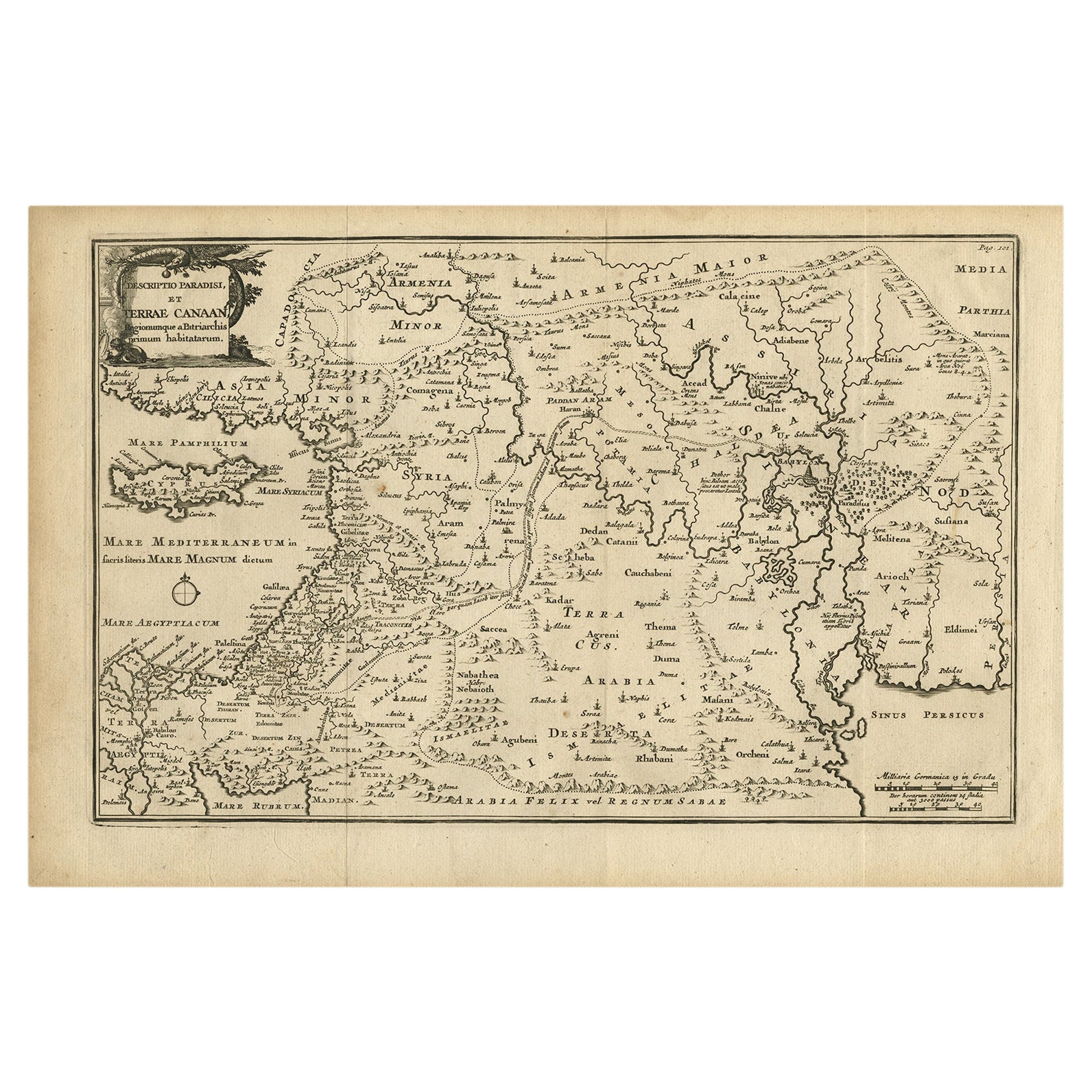
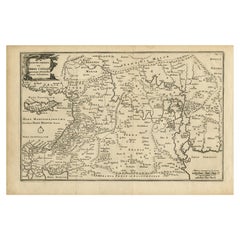
- Original Antique Map of Canaan, Armenia, Syria, Mesopotamia and Arabia, 1709Located in Langweer, NLAntique map titled 'Descriptio Paradisi et Terrae Canaan'. Original antique map of Canaan, Armenia, Syria, Mesopotamia and Arabia. It displays the Middle East from the eastern Mediterranean Sea to the Persian Gulf...Category
Antique Early 1700s Maps
MaterialsPaper
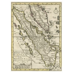
- Authentic Old Map of Sumatra, Malaysia and Singapore, 1745Located in Langweer, NLTitle: "Kaartje van't Eiland Sumatra en de Maleidse Kust gelegen na de stelling van de G. de L'Isle" Published by Jacob Keizer and by Jan de Lat Creator: Keizer, Jacob, active 1706...Category
Antique 1740s Maps
MaterialsPaper
- Original Antique Map of Greece and part of TurkeyLocated in Langweer, NLOriginal antique map titled 'La Grece ou partie meridionale de la Turquie d'Europe'. Small map of Greece and part of Turkey. This map originates from 'Le nouveau et curieux Atlas Geo...Category
Antique Early 18th Century Maps
MaterialsPaper
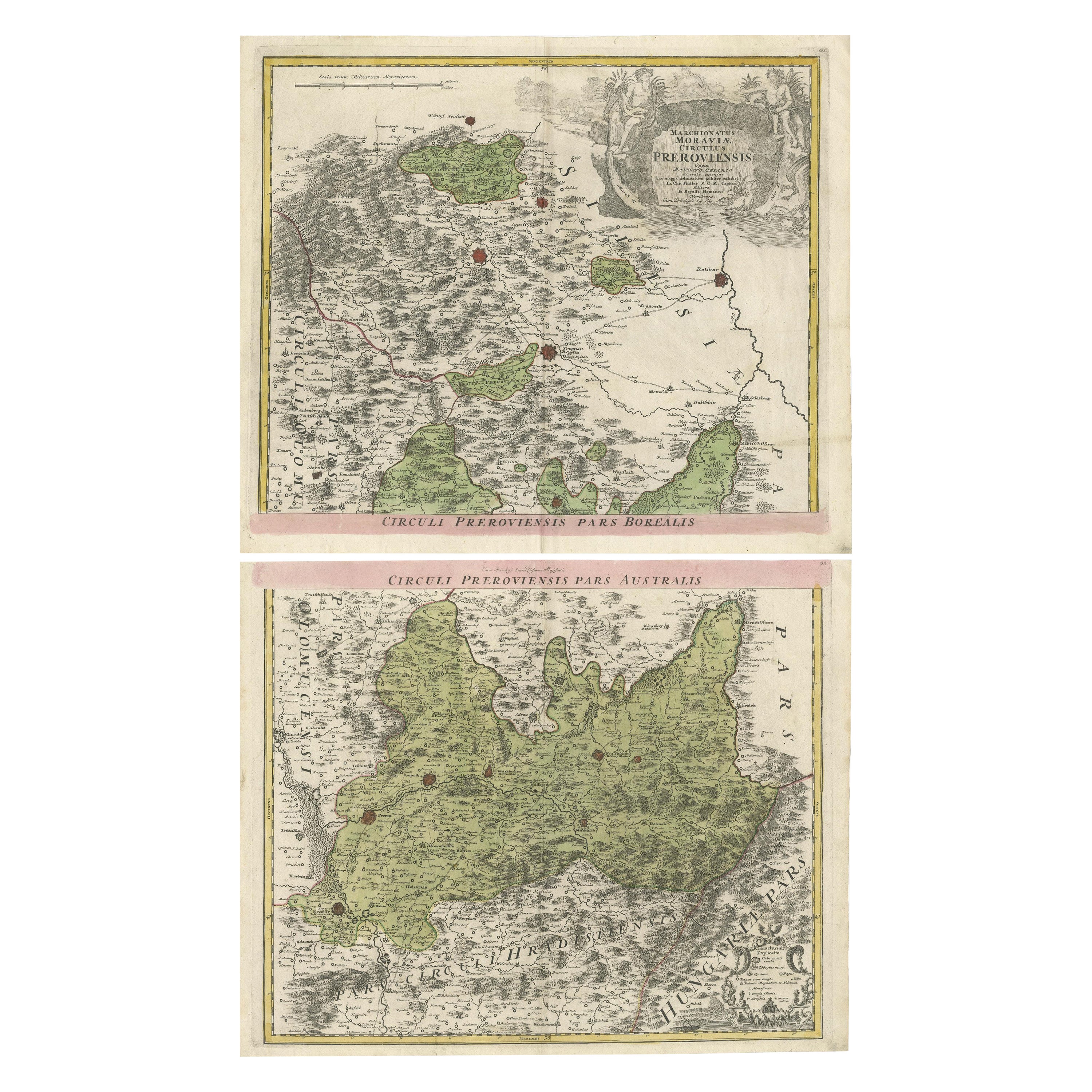
- Set of 2 Antique Maps covering part of modern-day Czech RepublicLocated in Langweer, NLSet of two antique maps titled 'Marchionatus Moraviae circulus Preroviensis'. Two individual sheets covering part of modern-day Czech Republic. Cities included are Opava, Fulnek, Lip...Category
Antique Early 18th Century Maps
MaterialsPaper
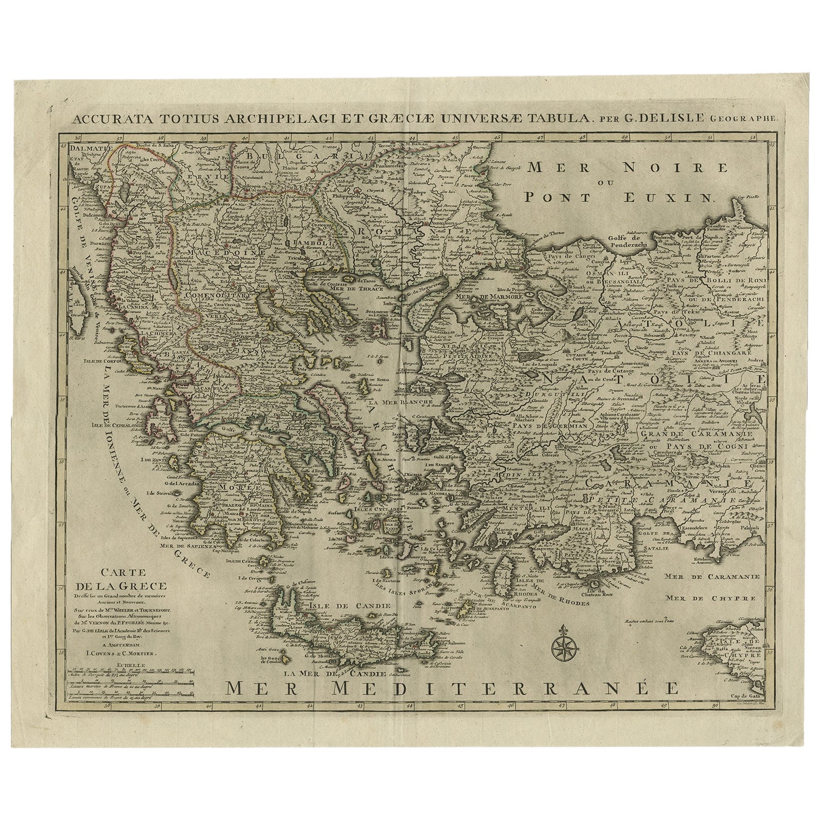
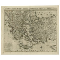
- Antique Map of Greece, Albania, Macedonia and Parts of Turkey and Cyprus, c.1745Located in Langweer, NLAntique map titled 'Accurata Totius Archipelagi Et Graeciae Universae Tabula'. Detailed map of Greece. Includes Albania, Macedonia and parts of Turkey and Cyprus. With compass rose...Category
Antique 18th Century Maps
MaterialsPaper


You May Also Like
- Old Nautical Map of CorsicaLocated in Alessandria, PiemonteST/556/1 - Old map of Corsica isle, surveyed by Captain Hell, of the French Royal Navy in 1824, engraved and published on 1874, with additions and corre...Category
Antique Early 19th Century English Other Prints
MaterialsPaper
- Old Horizontal Map of EnglandBy TassoLocated in Alessandria, PiemonteST/520 - Old rare Italian map of England, dated 1826-1827 - by Girolamo Tasso, editor in Venise, for the atlas of M.r Le-Sage.Category
Antique Early 19th Century Italian Other Prints
MaterialsPaper
- 1844 Map "Russia in Eurpoe, Part II to Part VIII", 7 Maps Ric.r023Located in Norton, MA1844 Map "Russia in Eurpoe, Part II to Part VIII" 7 Maps Ric.r023 Fine, original, steel-engraved Map of Russia in Europe Part II t oPart VIII, by the Society for the Diffusion of Useful Knowledge. Detailed map of the regions to the northeast of Moscow. Including Arkhangel, Vologda, Viatka, Perm, Olonetz, Iaroslavl. The SDUK began its map publishing project under the leadership of Captain Francis Beaufort R.N. in 1829, and published the maps in parts, haltingly, over the next 15 years, completing the series in 1844, finally permitting the publication of a whole atlas. Many of the maps were actually drawn by Beaufort, who at the time was the Hydrographer to the Royal Navy, and all were closely supervised by him. J. & C. Walker worked closely with Beaufort in engraving the maps. Finely engraved, carefully researched, the maps set...Category
Antique 19th Century Unknown Maps
MaterialsPaper
- Map of the Kingdom of Sardinia and Part of the Kingdom of Genoa, RomeBy Giovanni Maria CassiniLocated in Hamilton, Ontario18th century map by Italian engraver Giovanni Maria Cassini (Italy 1745-1824). Map of Part of the Kingdom of Sardinia and Part of the Kingdom of Genoa: Rome. This is a hand colored a...Category
Antique 18th Century Italian Maps
MaterialsPaper
- 1840 "New Map of the City of New York With Part of Brooklyn & Williamsburg"Located in Colorado Springs, COPresented is a hand-colored, engraved folding map titled "New Map of the City of New York With Part of Brooklyn & Williamsburg" by J. Calvin Smith. The map was issued bound in the bo...Category
Antique 1840s American Maps
MaterialsPaper
- 19th Century John Cary Map of North Part of West Riding of Yorkshire, C.1805By John CaryLocated in Royal Tunbridge Wells, KentAntique 19th century British original John Cary sr (1755-1835) map of North part of the West Riding of Yorkshire, From the beft Authorities. Engraved J Car...Category
Antique 19th Century British Maps
MaterialsPaper


Recently Viewed
View AllMore Ways To Browse
Map Of Ceylon
Old French Map
John Tallis Map
Australia Captain Cook
Map Zanzibar
Topographical Globe
Dan Rizzi
Formosa Vintage Map
Vincenzo Coronelli On Sale
Willem Blaeu On Sale
Antique Map Of Republic Of Texas
Antique Maps Denver
Cartier 1730
Collectible Barbies
Devonia Antique
J Karte
Map Cleveland
Union Pacific Map