Items Similar to Original Antique Map of the East India Islands 'Indonesia', ca.1820


Want more images or videos?
Request additional images or videos from the seller
1 of 5
Original Antique Map of the East India Islands 'Indonesia', ca.1820
About the Item
Antique map titled 'A Chart of the East India Islands'.
Old map of the East Indies. This map originates from 'A New Geographical Dictionary; Containing a Description of all the Empires, Kingdoms, States and Provinces' by J.W. Clarke.
Artists and Engravers: Published by Nuttall, Fisher & co.
Condition: Good, general age-related toning. Minor wear, blank verso. Please study image carefully.
About the Seller
5.0
Recognized Seller
These prestigious sellers are industry leaders and represent the highest echelon for item quality and design.
Gold Seller
Premium sellers maintaining a 4.3+ rating and 24-hour response times
Established in 2009
1stDibs seller since 2017
2,468 sales on 1stDibs
Typical response time: <1 hour
- ShippingRetrieving quote...Shipping from: Langweer, Netherlands
- Return Policy
Authenticity Guarantee
In the unlikely event there’s an issue with an item’s authenticity, contact us within 1 year for a full refund. DetailsMoney-Back Guarantee
If your item is not as described, is damaged in transit, or does not arrive, contact us within 7 days for a full refund. Details24-Hour Cancellation
You have a 24-hour grace period in which to reconsider your purchase, with no questions asked.Vetted Professional Sellers
Our world-class sellers must adhere to strict standards for service and quality, maintaining the integrity of our listings.Price-Match Guarantee
If you find that a seller listed the same item for a lower price elsewhere, we’ll match it.Trusted Global Delivery
Our best-in-class carrier network provides specialized shipping options worldwide, including custom delivery.More From This Seller
View AllOld Original Antique Map of the Islands of East Indonesia, 1756
Located in Langweer, NL
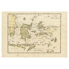
Title: Isles Moluques.
Old and rare, this decorative map of the Maluku Islands in the period it was still controlled by the Dutch colonial power. It also shows the island of Bali, Lombok, part of Borneo (Kalimantan), Celebes (Sulawesi), Timor, The Lesser Sunda Islands, West Papua...
Category
Antique 1750s Maps
Materials
Paper
$423 Sale Price
20% Off
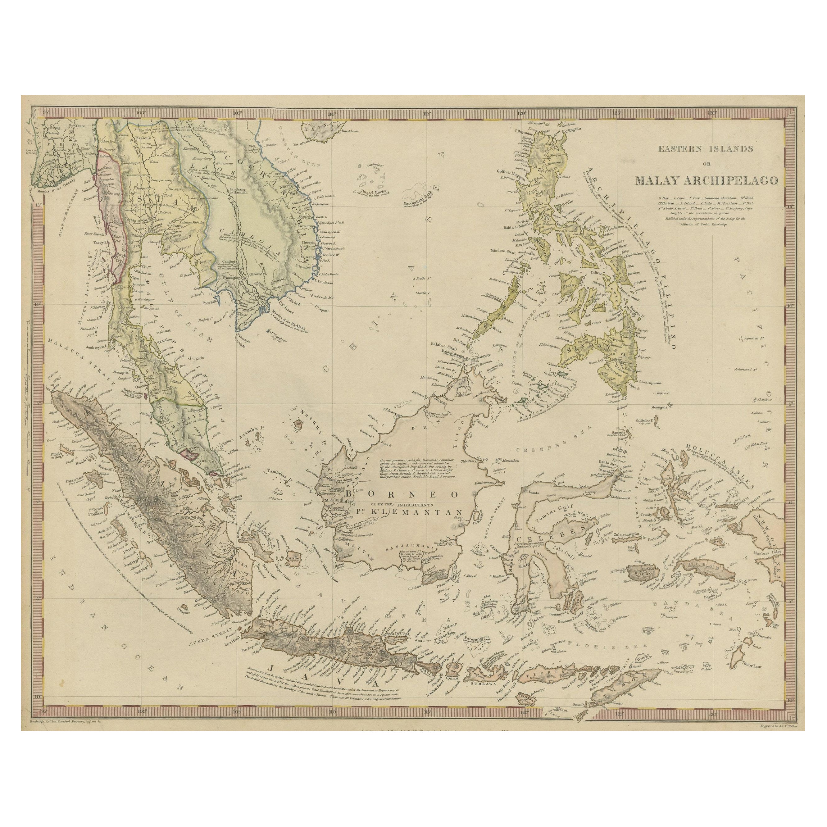
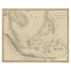
Original Antique Map of the Dutch East Indies, Nowadays Indonesia, ca.1840
Located in Langweer, NL
Original antique map of the East Indies including Borneo, Celebes, Java, Sumatra and surrounding islands. Published circa 1840.
Artists and Engravers: Engraved by J. & C. Walker....
Category
Antique 1840s Maps
Materials
Paper
$225 Sale Price
20% Off
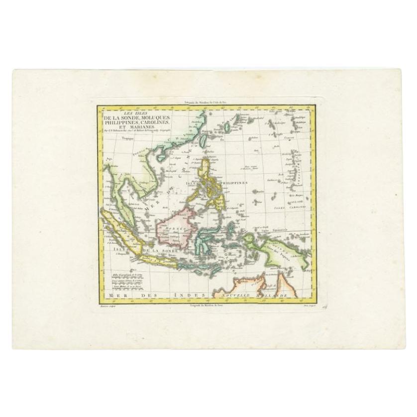
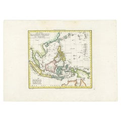
Antique Colourful Map of the Dutch East Indies 'Indonesia', ca.1806
Located in Langweer, NL
Antique map titled 'Les Isles de la Sonde Moluques Philippines, Carolines et Marianes'. Old map of the East Indies, also showing a part of Australia.
Artists and Engravers: Publi...
Category
Antique 19th Century Maps
Materials
Paper
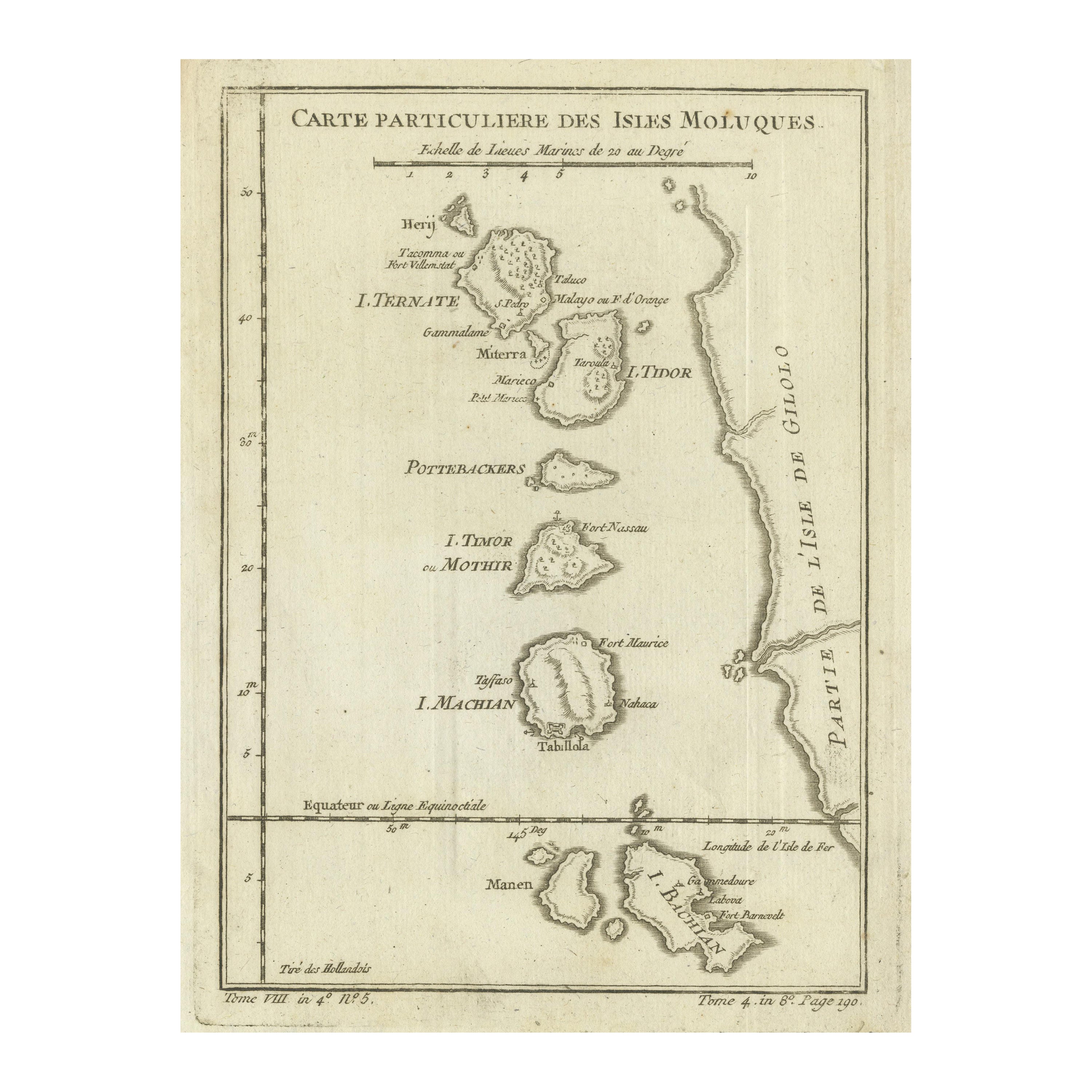
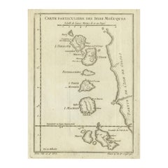
Original Antique Map of the Maluku Islands or Moluccas, Indonesia
Located in Langweer, NL
Antique map titled 'Carte Particuliere des Isles Moluques'. This map depicts the islands of Herij, Ternate, Tidor, Pottebackers, Timor, Machian and Bachian. The Moluccan islands were...
Category
Antique Mid-18th Century Maps
Materials
Paper
$103 Sale Price
20% Off
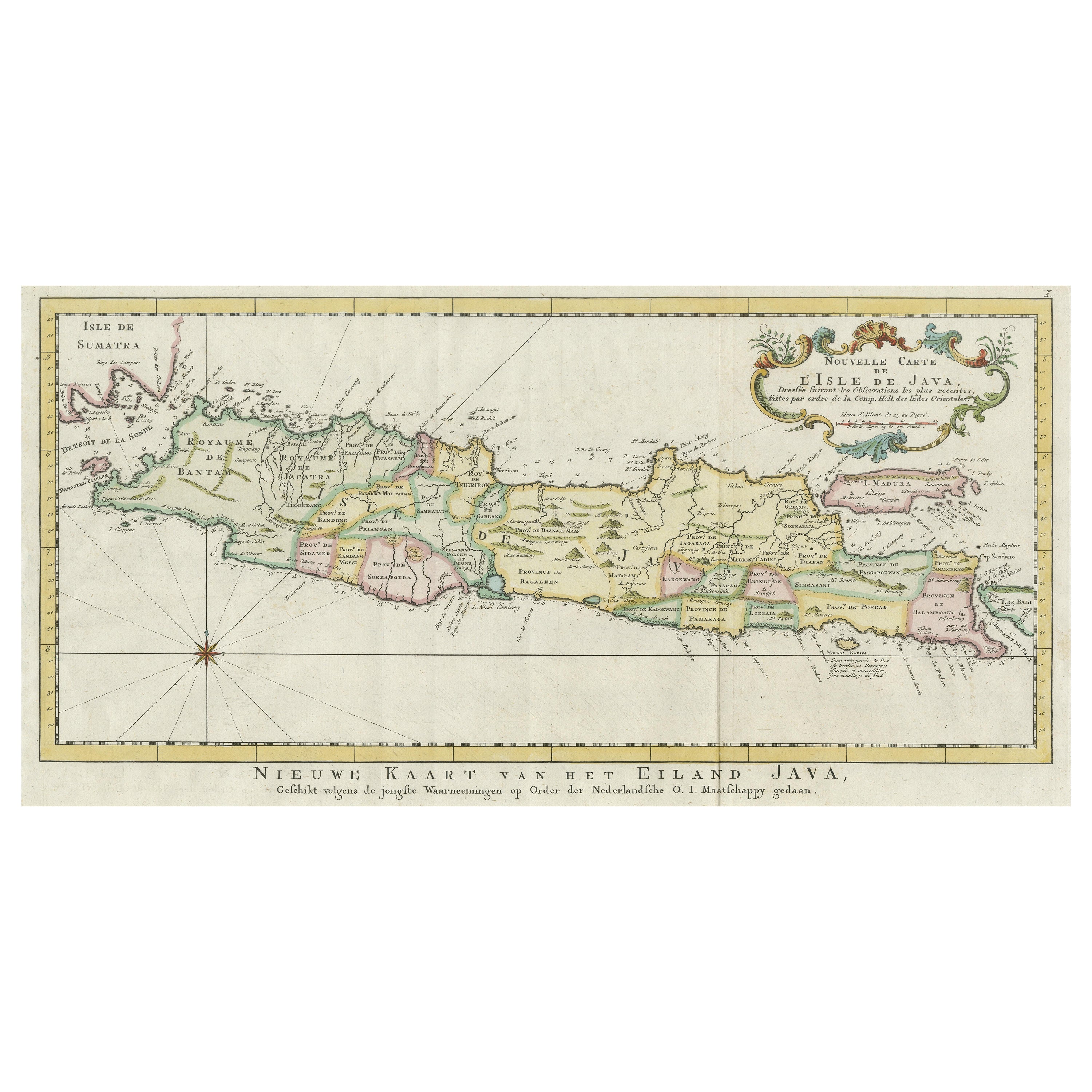
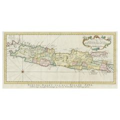
Antique Map of the Island of Java, Indonesia
Located in Langweer, NL
Antique map titled 'Nouvelle Carte de l'Isle de Java (..) - Nieuwe Kaart van het Eiland Java (..)'. Chart of the island of Java, depicting soundings around the coast, all principal h...
Category
Antique Late 18th Century Maps
Materials
Paper
$423 Sale Price
20% Off
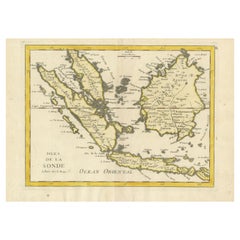
Old Original Antique Map of the Sunda Islands of Indonesia, 1756
Located in Langweer, NL
Title: Isles De La Sonde.
Attractive old decorative map of the Isles de la Sonde, Borneo, Sumatra, Java and Malacca ( Malaysia) with the Straits of Malacca. Penang is spelled as P...
Category
Antique 1750s Maps
Materials
Paper
$517 Sale Price
20% Off
You May Also Like
Large Original Antique Map of the The Windward Islands. 1894
Located in St Annes, Lancashire
Superb Antique map of The Windward Islands
Published Edward Stanford, Charing Cross, London 1894
Original colour
Good condition
Unframed.
Free shipping
Category
Antique 1890s English Maps
Materials
Paper

Large Original Antique Map of The Greek Islands. 1894
Located in St Annes, Lancashire
Superb Antique map of The Greek Islands
Published Edward Stanford, Charing Cross, London 1894
Original colour
Good condition
Unframed.
Free shipping
Category
Antique 1890s English Maps
Materials
Paper

Large Original Antique Map of The Falkland Islands. 1894
Located in St Annes, Lancashire
Superb Antique map of The Falkland Islands
Published Edward Stanford, Charing Cross, London 1894
Original colour
Good condition
Unframed.
Free shipping
Category
Antique 1890s English Maps
Materials
Paper

Large Original Antique Map of The Canary Islands. 1894
Located in St Annes, Lancashire
Superb Antique map of The Canary Islands
Published Edward Stanford, Charing Cross, London 1894
Original colour
Good condition
Unframed.
Free shipping
Category
Antique 1890s English Maps
Materials
Paper

Large Original Antique Map of The Leeward Islands. 1894
Located in St Annes, Lancashire
Superb Antique map of The Leeward Islands
Published Edward Stanford, Charing Cross, London 1894
Original colour
Good condition
Unframed.
Free shipping
Category
Antique 1890s English Maps
Materials
Paper

Original Antique Map of China, Arrowsmith, 1820
Located in St Annes, Lancashire
Great map of China
Drawn under the direction of Arrowsmith
Copper-plate engraving
Published by Longman, Hurst, Rees, Orme and Brown, 1820
Unfr...
Category
Antique 1820s English Maps
Materials
Paper

Recently Viewed
View AllMore Ways To Browse
Bergere Chairs 8
Biedermeier Tilt Top Table
Bing And Grondahl Tea
Birdcage Regency
Bitossi Side Table
Black Acrylic Chairs
Black And White Marble Ashtray
Black Herman Miller Bench
Black Roly Poly
Black Transferware
Blade Console
Block Blue Armchair
Blue Leather Sectional
Blue Willow Bowl
Blue Willow Japan
Bobbin Bench
Bomber Seat
Borge Mogensen Ottoman