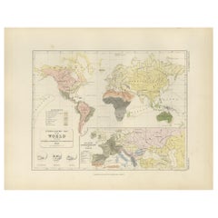
Original Antique Map of The World by John Rapkin, circa 1850
View Similar Items


Want more images or videos?
Request additional images or videos from the seller
1 of 5
Original Antique Map of The World by John Rapkin, circa 1850
About the Item
- Dimensions:Height: 11 in (27.94 cm)Width: 14.5 in (36.83 cm)Depth: 0.07 in (1.78 mm)
- Style:Other (In the Style Of)
- Materials and Techniques:Paper,Other
- Place of Origin:
- Period:
- Date of Manufacture:1850
- Condition:Wear consistent with age and use.
- Seller Location:St Annes, GB
- Reference Number:1stDibs: LU1836324414062
About the Seller
4.9
Platinum Seller
These expertly vetted sellers are 1stDibs' most experienced sellers and are rated highest by our customers.
1stDibs seller since 2016
2,581 sales on 1stDibs
Associations
International Confederation of Art and Antique Dealers' Associations
More From This SellerView All
- Original Antique Map of Belgium by Tallis, Circa 1850Located in St Annes, LancashireGreat map of Belgium Steel engraving Many lovely vignettes Published by London Printing & Publishing Co. ( Formerly Tallis ), C.1850 Origin...Category
Antique 1850s English Maps
MaterialsPaper
- Original Antique Map of The World by Thomas Clerk, 1817Located in St Annes, LancashireGreat map of The Eastern and Western Hemispheres On 2 sheets Copper-plate engraving Drawn and engraved by Thomas Clerk, Edinburgh. Published by Mackenzie And Dent, 1817 ...Category
Antique 1810s English Maps
MaterialsPaper
- Original Antique Map / City Plan of Brussels by Tallis, circa 1850Located in St Annes, LancashireGreat map of Brussels. Steel engraving. Published by London Printing & Publishing Co. (Formerly Tallis), C.1850 Free shipping.Category
Antique 1850s English Maps
MaterialsPaper
- Original Antique Map of South America, circa 1830Located in St Annes, LancashireGreat map of South America Copper plate engraving Published by Butterworth, Livesey & Co., circa 1830 Unframed.Category
Antique Early 1800s English Other Maps
MaterialsPaper

- Original Antique Map of South East Asia by Becker, circa 1840Located in St Annes, LancashireGreat map of South East Asia Steel engraving with original color outline Engraved by Becker Published by Virtue, circa 1840. Unframed.Category
Antique 1840s English Other Maps
MaterialsPaper
- Original Antique Map of Spain and Portugal, circa 1790Located in St Annes, LancashireSuper map of Spain and Portugal Copper plate engraving by A. Bell Published, circa 1790. Unframed.Category
Antique 1790s English Other Maps
MaterialsPaper


You May Also Like
- Antique Geological Map of the World by Johnston '1850'Located in Langweer, NLAntique map titled 'The Geological Structure of the Globe'. Original antique geological map of the world. This map originates from 'The Physica...Category
Antique Mid-19th Century Maps
MaterialsPaper
- Antique Rain Map of the World by Johnston '1850'Located in Langweer, NLAntique map titled 'Hyetographic or Rain Map of the World'. Original antique rain map of the world. This map originates from 'The Physical Atlas of Natural Phenomena' by A.K. Johnsto...Category
Antique Mid-19th Century Maps
MaterialsPaper
- Antique Ethnographic Map of the World by Johnston '1850'Located in Langweer, NLAntique map titled 'Ethnographic map of the world showing the present distribution of the leading races of man'. Original antique ethnographic map...Category
Antique Mid-19th Century Maps
MaterialsPaper
- Antique Map showing Isotherm Lines throughout the World by Johnston '1850'Located in Langweer, NLAntique map titled 'Humboldt's System of Isothermal Lines'. Original antique map showing isotherm lines throughout the world. This map originates from 'The Physical Atlas of Natural ...Category
Antique Mid-19th Century Maps
MaterialsPaper
- Antique Map of the World by Balbi '1847'Located in Langweer, NLAntique map titled 'Planisphère'. Original antique map of the world. This map originates from 'Abrégé de Géographie (..)' by Adrien Balbi. Pub...Category
Antique Mid-19th Century Maps
MaterialsPaper
 $219 Sale Price20% Off
 - Antique Map of the World by A. Vuillemin, 1854By Victor LevasseurLocated in Langweer, NLThis map originates from ‘Atlas National de la France Illustré’. Published by A. Combette, Paris, 1854.Category
Antique Mid-19th Century Maps
MaterialsPaper
 $308 Sale Price25% Off