Items Similar to Original Steel Engraved Map of French Colonies in America, 1854


Want more images or videos?
Request additional images or videos from the seller
1 of 9
Original Steel Engraved Map of French Colonies in America, 1854
About the Item
Antique map titled 'Colonies Francaises (en Amerique)'. Detailed map bordered by vignettes showing local animals, produce and activities of the various French Colonies in America. This map originates from ‘Atlas National de la France Illustré’. Published by A. Combette, Paris, 1854.
On the antique map "Colonies Françaises (en Amérique)," several areas stand out as particularly special due to their historical significance, natural resources, or cultural prominence. Here are some notable regions highlighted on the map:
1. **French West Indies**: This includes the islands of Martinique, Guadeloupe, Saint Martin, Saint Barthélemy, and others. Known for their sugar plantations, rum production, and vibrant Creole culture, these islands were key components of the French colonial empire in the Caribbean.
2. **French Guiana**: Located on the northeastern coast of South America, French Guiana is known for its dense rainforests, diverse wildlife, and infamous Devil's Island, a former penal colony.
3. **Louisiana**: While much of Louisiana had been sold to the United States in the Louisiana Purchase of 1803, French influence and culture remained strong in the region, particularly in New Orleans and surrounding areas.
4. **Québec**: This Canadian province was a significant French colonial settlement and retains a strong French cultural identity to this day. Québec City, founded in 1608, is one of the oldest European settlements in North America.
5. **Haiti**: The western part of the island of Hispaniola, Haiti was a French colony known for its lucrative sugar plantations worked by enslaved Africans. It became the site of the only successful slave revolt in history, leading to its independence from France in 1804.
6. **French Guyana**: This territory, located on the northeastern coast of South America, was a site of French penal colonies and remains an overseas department of France today.
These areas are highlighted not only for their geographic significance but also for their historical, cultural, and economic importance within the French colonial empire in the Americas. The vignettes around the map's border likely depict scenes and products specific to these regions, further emphasizing their uniqueness and importance.
This antique map titled "Colonies Françaises (en Amérique)" holds several characteristics that make it special:
1. **Detailed Representation**: The map offers a detailed depiction of the French colonies in America during the mid-19th century. This level of detail provides insights into the geographic extent and layout of these colonies during this historical period.
2. **Vignettes**: The inclusion of vignettes around the map's border showcasing local animals, produce, and activities of the various French colonies adds both decorative and informative elements. These vignettes provide a glimpse into the cultural and natural diversity of the regions depicted on the map.
3. **Historical Context**: Produced in 1854, the map provides a snapshot of the French colonial presence in America during a time when European powers were actively colonizing and competing for territories in the New World. Understanding the historical context surrounding the map's creation enriches its significance.
4. **Publication Details**: The map originates from the "Atlas National de la France Illustré," published by A. Combette in Paris. The association with this renowned atlas adds to the map's provenance and prestige.
5. **Artistic Value**: Beyond its informational content, the map likely possesses artistic value through its design, typography, and decorative elements. Antique maps of this nature often appeal to collectors and enthusiasts for their aesthetic qualities.
Overall, the combination of historical, geographical, and artistic elements makes this antique map a special and valuable piece, offering not only cartographic information but also insights into the cultural and natural landscapes of the French colonies in America during the 19th century.
- Dimensions:Height: 13.12 in (33.3 cm)Width: 18.71 in (47.5 cm)Depth: 0.02 in (0.5 mm)
- Materials and Techniques:
- Period:
- Date of Manufacture:1854
- Condition:General age-related toning. Minor wear and soiling, light pencil notation below title. Blank verso. Please study image carefully.
- Seller Location:Langweer, NL
- Reference Number:
About the Seller
5.0
Platinum Seller
These expertly vetted sellers are 1stDibs' most experienced sellers and are rated highest by our customers.
Established in 2009
1stDibs seller since 2017
1,922 sales on 1stDibs
Typical response time: <1 hour
- ShippingRetrieving quote...Ships From: Langweer, Netherlands
- Return PolicyA return for this item may be initiated within 14 days of delivery.
More From This SellerView All
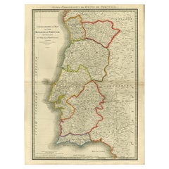
- Engraved Large Map of The Kingdom of Portugal Original Handcolored, 1854Located in Langweer, NLAntique map titled 'Mappa Corografica do Reino de Portugal - Chorographical map of the Kingdom of Portugal divided into its Grand Provinces.' Large map of...Category
Antique 1850s Maps
MaterialsPaper
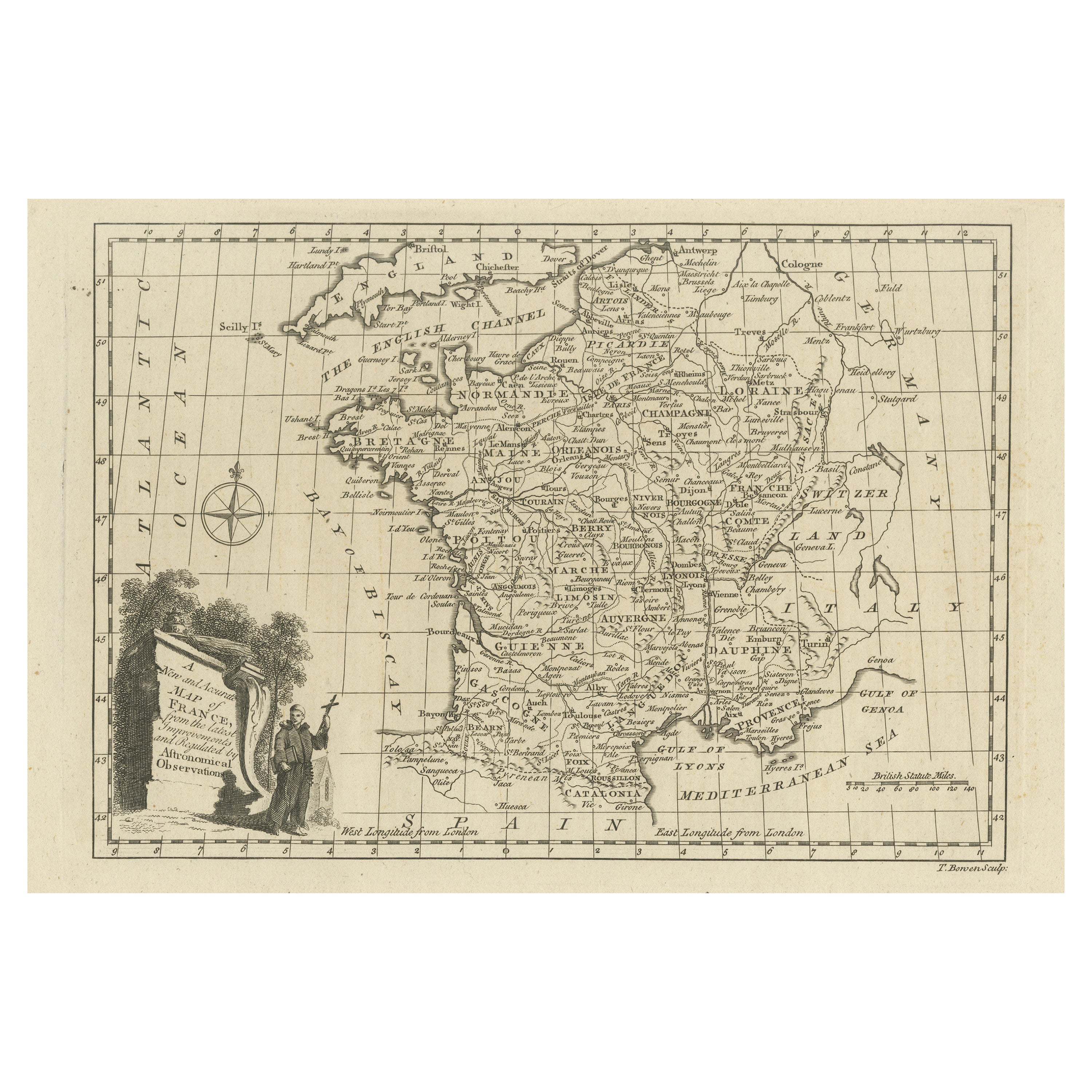
- Original Copper Engraved Map of FranceLocated in Langweer, NLAntique map titled 'New and Accurate Map of France from the latest improvements'. Original copper engraved map of France. Engraved by T. Bowen, published circa 1771.Category
Antique Late 18th Century Maps
MaterialsPaper
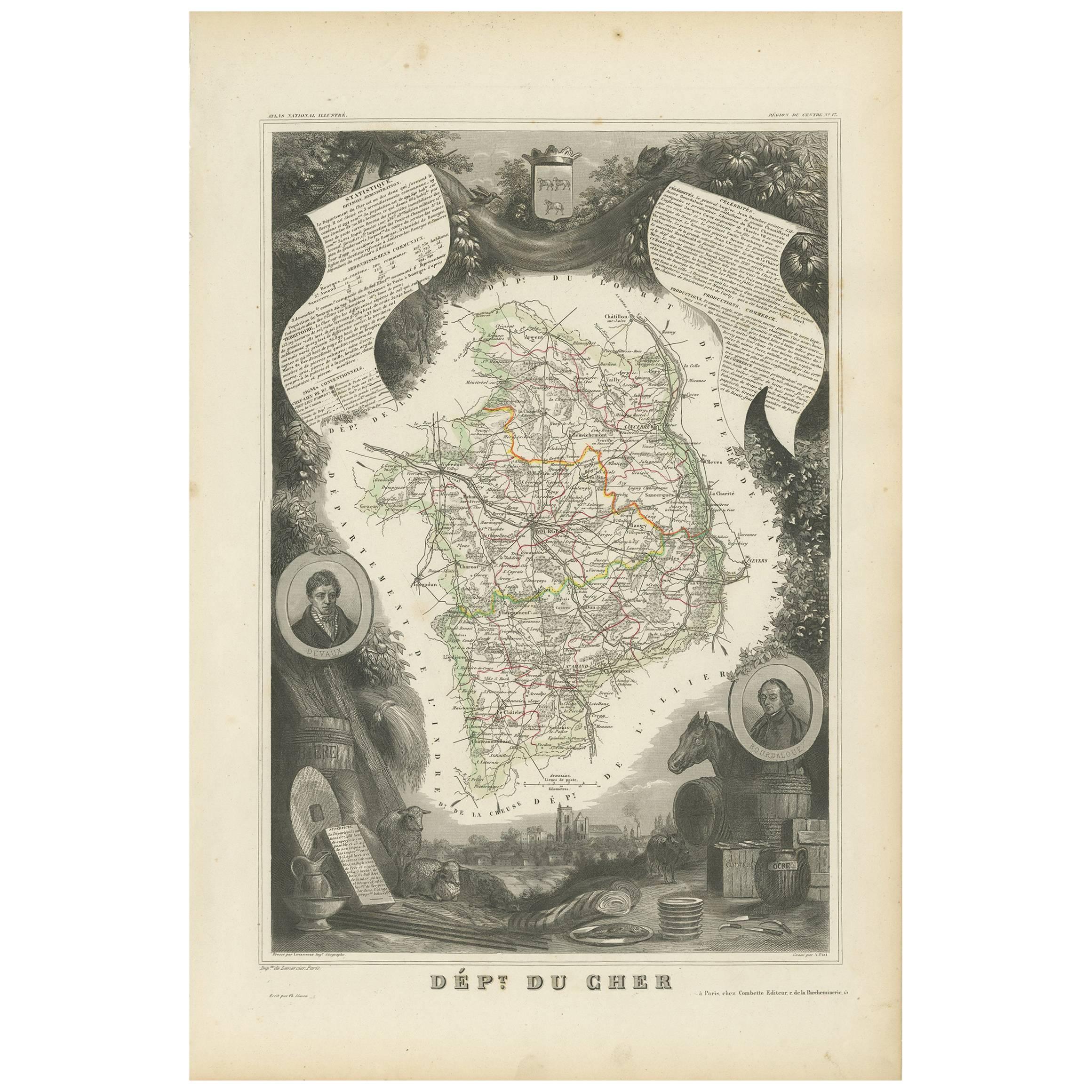
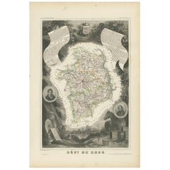
- Antique Map of Cher in France, 1854By Victor LevasseurLocated in Langweer, NLAntique map titled 'Dépt. des Bses. Pyrénées'. Map of the French department of Basses Pyrenees, France. This department includes the Jurancon wine region, famous for its production d...Category
Antique Mid-19th Century Maps
MaterialsPaper
- Antique Map of Algeria and the French Colonies, 1875Located in Langweer, NLAntique map titled 'Algérie et Colonies Francaises'. Large map of Algeria and the French Colonies. This map originates from 'Atlas de Géographie Moderne Physique et Politique' by A. ...Category
Antique Late 19th Century Maps
MaterialsPaper
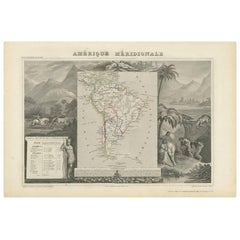
- Antique Map of South America by V. Levasseur, 1854By Victor LevasseurLocated in Langweer, NLAntique map titled 'Amérique Méridionale'. Map shows South America, beautiful surrounded by typical scenes of natives and their life. Depicting Colombia, Brazil, Chile, Bolivia and m...Category
Antique Mid-19th Century Maps
MaterialsPaper
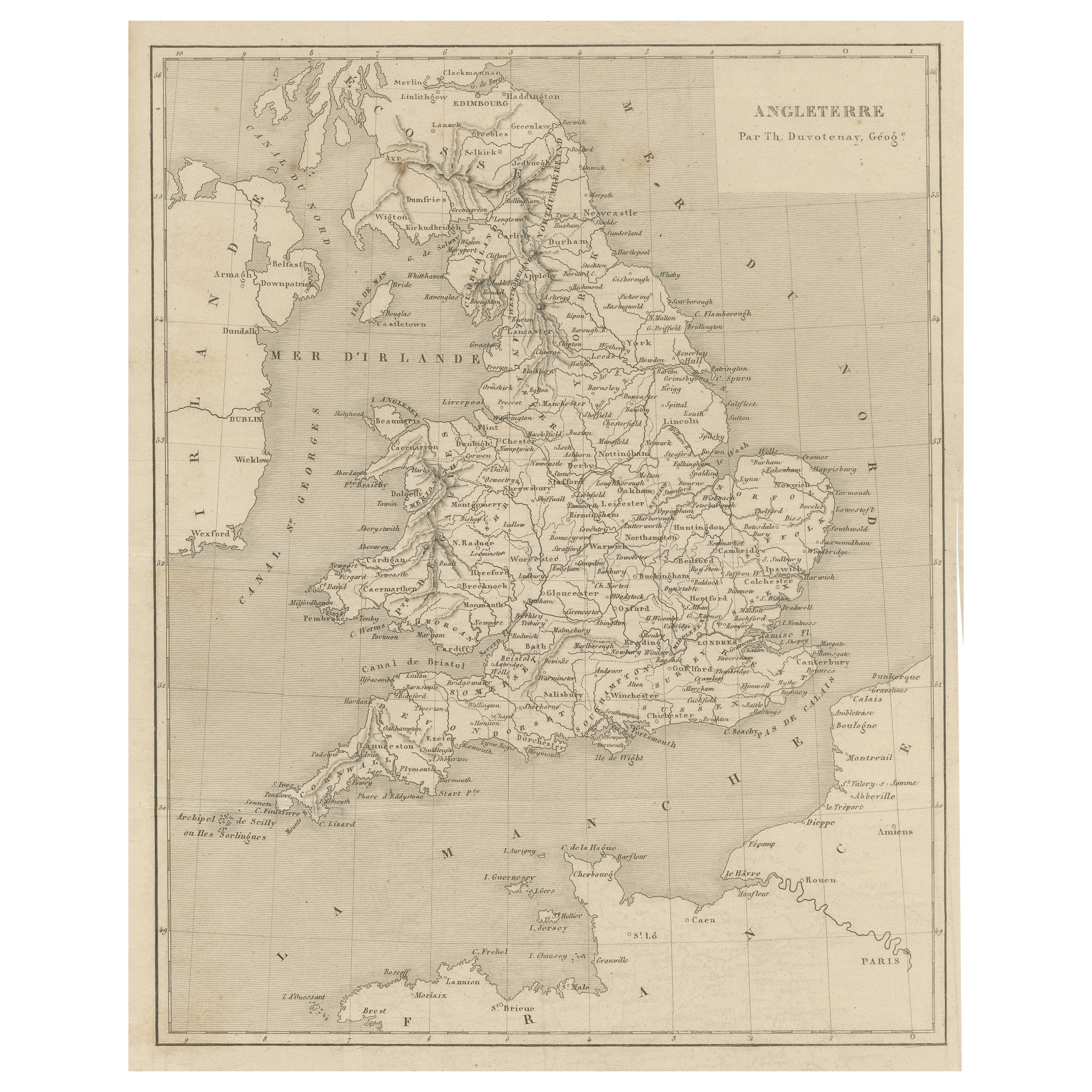
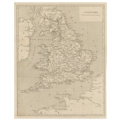
- Steel Engraved Antique Map of EnglandLocated in Langweer, NLAntique map titled 'Angleterre'. Original antique map of England. Engraved by Th. Duvotenay. Originates from 'Complement de L'Encyclopedie Mode...Category
Antique Late 19th Century Maps
MaterialsPaper


You May Also Like
- Map Colonies Francaises Martinique, 1845Located in BUNGAY, SUFFOLKColonies Francaises, Martinique, Amerique DU SUD Geographie et Statistique par V.Levasseur. Ing'r Geographe. Illustre par Raymond Bonheur, peintre. Grave par Laguihermie, Rue St...Category
Antique 19th Century French Maps
MaterialsPaper
- Original Antique Map of South America. C.1780Located in St Annes, LancashireGreat map of South America Copper-plate engraving Published C.1780 Two small worm holes to left side of map Unframed.Category
Antique Early 1800s English Georgian Maps
MaterialsPaper
- Original Antique Map of Switzerland, Engraved By Barlow, Dated 1807Located in St Annes, LancashireGreat map of Switzerland Copper-plate engraving by Barlow Published by Brightly & Kinnersly, Bungay, Suffolk. Dated 1807 Unframed.Category
Antique Early 1800s English Maps
MaterialsPaper
- 1854 Map of Massachusetts, Connecticut and Rhode Island, Antique Wall MapLocated in Colorado Springs, COThis striking wall map was published in 1854 by Ensign, Bridgman & Fanning and has both full original hand-coloring and original hardware. This impression is both informative and highly decorative. The states are divided into counties, outlined in red, green, and black, and subdivided into towns. Roads, canals, and railroad lines are prominently depicted, although they are not all labeled. The mapmakers also marked lighthouses, banks, churches, and prominent buildings, with a key at right. The map is an informative and comprehensive overview of the infrastructural development of New England prior to the Civil War. Physical geographies depicted include elevation, conveyed with hachure marks, rivers and lakes. The impression features an inset map of Boston...Category
Antique 19th Century American Maps
MaterialsPaper
- Original Antique Map of South America, circa 1830Located in St Annes, LancashireGreat map of South America Copper plate engraving Published by Butterworth, Livesey & Co., circa 1830 Unframed.Category
Antique Early 1800s English Other Maps
MaterialsPaper
- Original Antique Map of The Netherlands, Engraved by Barlow, Dated 1807Located in St Annes, LancashireGreat map of Netherlands Copper-plate engraving by Barlow Published by Brightly & Kinnersly, Bungay, Suffolk. Dated 1807 Unframed.Category
Antique Early 1800s English Maps
MaterialsPaper


