1940s Maps
to
2
2
1
2,936
2,181
477
3
289
35
10
127
7
35
9
2
5
4
4
2
2
2
2
2
2
2
Period: 1940s
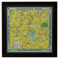
1948 "A Hysterical Map of Yellowstone National Park" by Jolly Lindgren, 2nd Ed.
Located in Colorado Springs, CO
Presented is a second edition printing of Jolly Lindgren’s “Hysterical Map of Yellowstone National Park.” This comical pictorial map h...
Category
American Vintage 1940s Maps
Materials
Paper
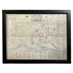
1943 "USO Map Guide to Washington"
Located in Colorado Springs, CO
This is a WWII map of Washington, DC, issued as a guide for service men and women visiting or working in the city during the war. The map was created by Allen F. Free and published a...
Category
American Mid-Century Modern Vintage 1940s Maps
Materials
Paper
Related Items
Where Chefs Eat Book - A Guide to Chefs' Favorite Restaurants
Located in New York, NY
Eat around the world with 650 of the world's best chefs.
Wherever you are, you’ll never miss the best local diner for breakfast, the best restaurant for a business dinner, or the best place for a late night snack - and everything in between.
This all-new, completely revised, third edition of the global restaurant guidebook that has sold more than 250,000 copies features more than 7,000 recommendations for more than 4,500 restaurants in more than 70 countries.
Wherever you are, you'll never miss the best local diner for breakfast, the best restaurant for a business dinner, or the best place for a late night snack – and everything in-between. With city maps, key information, reviews and recommendations from the chefs themselves, this is the guide for savvy restaurant-goers and armchair foodies in major cities and towns worldwide.
Where: With recommendations in more than 70 countries - from the United States to Buenos Aires from Ireland to Estonia from Greece to South Africa, discover the best eateries for your destination.
Chefs: Find out where and what the world's best chefs eat including: Jason Atherton, Shannon Bennett, Helena Rizzo, Stephen Harris, Yotam Ottolenghi, Yoshihiro Narisawa, and hundreds more.
Eat: From breakfast to late night, bargain to high end - discover the best places to eat for just the right occasion. Joe Warwick is a London-based food writer and critic who started the World's 50 Best...
Category
European 1940s Maps
Materials
Paper
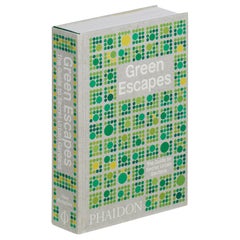
Green Escapes, The Guide to Secret Urban Gardens
Located in New York, NY
An insider's guide to the world's greatest 'secret' gardens, green spaces, and pocket parks tucked away in cities around the globe
Cities everywhere are graced with charming but...
Category
1940s Maps
Materials
Paper
Roman Carved Marble Torso in Military Dress, circa 2nd-3rd Century
Located in Austin, TX
A well carved Roman marble figure of a male in military dress, late Roman Period, circa 2nd-3rd century.
The figure portrayed dressed in military att...
Category
Italian Classical Roman Antique 1940s Maps
Materials
Marble
Reference Book Chinese - Chinese Furniture: A Guide to Collecting Antiques, 2006
Located in Amsterdam, Noord Holland
Chinese Furniture: A Guide to Collecting Antiques Hardcover - November 15, 2006
by Karen Mazurkewich(Author), A. Chester Ong(Author)
The international market for antique Chinese fur...
Category
1940s Maps
Materials
Paper
H 0.04 in W 0.04 in D 0.04 in
Charm School: the Schumacher Guide to Traditional Decorating for Today
Located in New York, NY
More than 250 rooms by iconic designers – the definitive illustrated handbook on the timeless style of grand millennial-chic
Chintz, ruffles, wicker, and skirts: old-school decoratin...
Category
1940s Maps
Materials
Paper
1842 The Knights Templars 2nd Edition London
Located in Stamford, CT
The Knights Templars of the Inner Temple by Charles G. Addison 1842 2nd Edition. London, England.
Original red leather binding in original condition.
Category
British Neoclassical Antique 1940s Maps
Materials
Leather, Paper
Guide to American Pewter by Carl Jacobs, First Edition
By Carl Jacobs
Located in valatie, NY
A Guide to American Pewter by Carl Jacobs. NY: The McBride Company, 1957. First edition hardcover with dust jacket. 216 pp. A guide to pewter for the c...
Category
American 1940s Maps
Materials
Paper
Small Antique Baedeker's South Eastern France Guide Book, Provence, Travel Maps
Located in Hele, Devon, GB
This is a delightful antique edition of Baedeker's South Eastern France guide book, complete with superb fold-out maps, centre-fold maps and informative text. A bound and intact late...
Category
British Late Victorian 1940s Maps
Materials
Paper
H 6.3 in W 4.34 in D 0.99 in
Martin Parr 2nd Edition Monograph
Located in New York, NY
The acute observation, wit and color of Martin Parr's work since the mid-1980s has established him as one of the most successful and popular contemporary photographers and a leading ...
Category
Slovenian 1940s Maps
Materials
Paper
Coronation Plate Queen Elizabeth II June 2nd 1953 Burleigh Ware Burslem England
Located in North Hollywood, CA
Coronation Plate Queen Elizabeth II June 2nd 1953 Burleigh Ware Burslem England.
Beautiful plate commemorating the Coronation of Her Majesty Queen E...
Category
British Elizabethan 1940s Maps
Materials
Porcelain
National Gallery of Art, Washington by John Walker
Located in valatie, NY
National Gallery of Art, Washington by John Walker. Published by Harry N. Abrams Incorporated, New York, NY, 1975. Hardcover with dust jacket. Director Eme...
Category
American Vintage 1940s Maps
Materials
Paper
Handmade Houses A Guide to the Woodbutcher's Art by Art Boericke
Located in valatie, NY
Handmade Houses: A Guide to the Woodbutcher's Art by Art Boericke. Scrimshaw Press, California, 1973. 3rd printing hardcover with dust jacket. The book is a photo-journey through the...
Category
American Vintage 1940s Maps
Materials
Paper
Previously Available Items
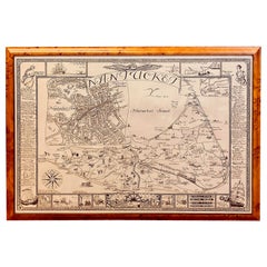
Vintage Map of Nantucket Town by Ruth Haviland Sutton, 1946
Located in Nantucket, MA
Vintage Map of Nantucket Town by Ruth Haviland Sutton, 1946, a classic vintage tourist map of Nantucket Island showing historic landmarks and geogr...
Category
American Other Vintage 1940s Maps
Materials
Paper
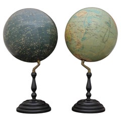
Pair of Philip & Son Globes, circa 1946
Located in London, GB
A wonderful set of Terrestrial and Celestial 12 inch globes by George Philip and Son. Presented on brass inclined plain mounts attached to original turned ebonized wooden bases and uprights with axes secured at the top by brass acorn finials. Unusually, the terrestrial globe has a copyright date shown under the cartouche, 1946.
The celestial globe is printed in beige against a dark blue background and shows the constellations and many named stars. Solid lines connect the stars within constellations rather than illustrating them as mythological and other figures.? A cartouche is present that includes the title and maker's address.
When looking at the stars from Earth the viewpoint is effectively inside a celestial sphere. The surface of a celestial globe shows the star field as a projection viewed from the outside and is therefore reversed, with the constellations appearing as their mirror images.
The terrestrial globe is printed in several colours and comprises of twelve coated lithographic paper gores with polar calottes over a twelve inch card sphere. The age of the globe has been confirmed by the political borders and named cities displayed. The globe is nicely detailed and has a grid network of parallels and meridians. It shows all the continents and countries as they were at the time it was printed and also indicates all the principal steamship routes with distances in nautical miles. The globe also has a printed Analemma - a diagram showing the declination of the Sun for every day in the year and the equation of time. The Analemma therefore shows the position of the Sun in the sky as seen from a fixed location on Earth at the same mean solar time, as the sun's position varies over the course of a year. A cartouche is present that includes the title and maker's address.
Dimensions of each globe: 30.5 cm/12 inches (diameter) x 59 cm/23 1/4 inches (max height).
George Philip, (1800–1882) was a cartographer and map publisher. He founded George Philip & Sons in 1834 in Liverpool primarily as a bookseller and stationer, but rapidly expanding to become a publisher of primarily maps, atlases and educational works. He had one son, also George (1823–1902), who was admitted to the business in 1848.
George senior was born in Huntly, Aberdeenshire and by 1819 he had become assistant to the Liverpool bookseller, William Grapel before going on to start his own business. He used cartographers (such as John Bartholomew the elder, August Petermann, and William Hughes) to produce maps on copper plates. Philip then had these printed and hand-coloured by his women tinters. The business expanded rapidly and by the time he produced his county maps of 1862 he was using machine...
Category
British Vintage 1940s Maps
Materials
Brass
1945, "Supervue of New York City"
Located in Colorado Springs, CO
This bird’s eye view of New York City was published in 1945 by the Supervue Map and Guide Organization. The map shows the roads and major points of interest, which, coupled with a detailed index surrounding the map, helped tourists locate key attractions, historical sites, steamship piers, parks and squares, and bridges.
The map was originally issued folded into printed paper covers with black and white photographic images of the city. On the verso of the map are small black and white maps...
Category
American Vintage 1940s Maps
Materials
Paper
Old Map Chest
Located in Eindhoven, NL
Old oak chest of drawers especially for maps and/o drawings. Cabinet consists of 2 parts. Entirely in perfect condition.
Origin: England
Period: Approx. 1940
Size 95cm x 68cm x H....
Category
English Vintage 1940s Maps
Materials
Oak
Old Map Chest
Located in Eindhoven, NL
Old oak chest of drawers especially for maps and/o drawings. Cabinet consists of 2 parts. Entirely in perfect condition.
Origin: England
Period: Approx. 1940
Size 116cm x 78cm x H...
Category
English Vintage 1940s Maps
Materials
Oak
Vintage World Globe on Mahogany Stand
Located in Lambertville, NJ
Handsome Scholarly world globe with a Regency style mahogany base. The globe is 16 inches in diameter, circa 1940, Chicago. Perfect addition to a library or study.
Category
American Regency Vintage 1940s Maps
Materials
Mahogany
"Geographically Correct Map of the United States" Vintage Map, circa 1940
Located in Colorado Springs, CO
This large map of the United States was issued by Rand McNally and Company on behalf of the Union Pacific Railroad. The map embraces the whole of the United States, illustrating the routes of the Union Pacific Railroad and its many subsidiaries. This scarce railroad map was issued exclusively for company use at larger stations.
Railroad routes for the Union Pacific Railway are boldly printed in red and white. Indian reservations and National Parks are also marked. In the lower left corner is an inset map showing the Pacific Ocean and principal steamship lines, while an inset map showing the Atlantic Ocean and the principal steamship lines can be found in the lower right. Sun Valley Resort appears on this map. It was founded in 1936 by the chairman of the Union Pacific Railroad, primarily to increase ridership on U.P. passenger trains in the Western United States and can be seen in the heavily tracked area of Idaho.
The Union Pacific Rail Road was founded in July of 1862, during the second year of the American Civil War. It was incorporated under an act of Congress, the Pacific Railroad Act of 1862. The act was approved by President Lincoln and provided for the construction of railroads from the Missouri River to the Pacific as a war measure for the preservation of the Union. The Union Pacific was constructed in two parts, westward from Council Bluffs, Iowa to meet the Central Pacific Railroad line, which was constructed eastward from Sacramento, California. The railroad tycoon Leland Stanford drove the Golden Spike...
Category
American Vintage 1940s Maps
Materials
Paper
20th Century French Bar World Globe, 1940s
Located in LEGNY, FR
Very nice and original 20th century French rolling bar world globe from the 1940s.
Wooden structure covered by a paper world map. Opening top to store bottles.
The inside is covere...
Category
French Vintage 1940s Maps
Materials
Wood
Map of United States, World War II Vintage Pictorial Map, circa 1943
Located in Colorado Springs, CO
A striking pictorial map by Stanley Turner, published in 1943. The map presents the United States during World War II and is so titled “United States at War.” Around the map’s edges ...
Category
Canadian Vintage 1940s Maps
Materials
Paper
Hammond's Map of the Mediterranean, Europe, and Africa, circa 1941
Located in Colorado Springs, CO
This is an original WWII folding folio map of the Mediterranean, Europe, and Africa. The map was one of six foldout maps in a color lithographic folio titled "Battle Maps: Covering All War Fronts", published between 1941 and 1944.
The map is incredibly detailed and indicates Naval and Air bases, vital military resources, air raids, supply lines, and tracks mileages between key cities...
Category
Vintage 1940s Maps
1948 Official "Texas Brags" Vintage Map of North America
Located in Colorado Springs, CO
This is a uniquely Texas-centered, tongue-in-cheek map of the United States, published in 1948. The map reflects a massive Texas, prominently occupying the center and south of the United States, with all other states squeezed to the northeast and northwest. In fact, the Northeastern states are humorously shown as "unannexed territory" and the western states as "ceded territory."
The map is populated with decorative accents and colorful, humorous pictographs. They include a tornado, called "interpanhandle wheat harvester", the “orneriest rattlesnakes", and a rodeo cowboy described as “the man that couldn't be throw'd and the horse that couldn't be rode." The pictographs boast the best of everything in Texas: "prickliest pears," "most cantankerous coyotes," “unloansome pines,” and similar. Along the border illustrations are depictions of Texas life and history, including The Alamo and San Jacinto Monument as well as more modern skyscrapers. The map is drawn to a scale of “1 inch = 5 Texas Grapefruit.”
The map was published in Texas by John Randolph with Mark Storm...
Category
American Vintage 1940s Maps
Materials
Paper
Framed New York Central Railway Map Original from 1943 with Railway Label
By Baker, Jones, Hausauer, Inc. 1
Located in Ottawa, Ontario
Framed New York Central Railway Map Original from 1943 With Railway Label, The map is by Baker, Jones, Hausauer, Inc. Buffalo, N.Y. The map covers all line...
Category
American Mid-Century Modern Vintage 1940s Maps
Materials
Paper
H 26.5 in W 41 in D 0.75 in
