Items Similar to Rare 18th C. Newport Map

Want more images or videos?
Request additional images or videos from the seller
1 of 6
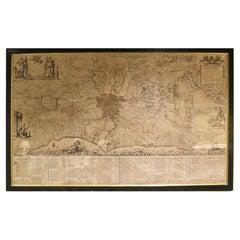
Rare 18th C. Newport Map
$19,500per item
£14,885.52per item
€17,111.90per item
CA$27,439.99per item
A$30,514.40per item
CHF 16,026.82per item
MX$373,069.19per item
NOK 199,709.60per item
SEK 188,272.22per item
DKK 127,710.11per item
Quantity
About the Item
Rare 18th C, Map titled "A plan of the town of Newport in the province of Rhode Island". Earliest printed plan of Newport, published for the use of the British just prior to their occupation in 1776. Issued in the Atlantic Neptune, an atlas of North American waters published by J.F.W. Des Barres 1776.
Great condition, professionally mounted and framed. Measures 29-1/2" by 21" sight, 37" by 27-3/4" framed.
- Dimensions:Height: 37 in (93.98 cm)Width: 27.5 in (69.85 cm)Depth: 2 in (5.08 cm)
- Materials and Techniques:
- Place of Origin:
- Period:1770-1779
- Date of Manufacture:1776
- Condition:Minor fading.
- Seller Location:Sandwich, MA
- Reference Number:Seller: PMABFNP1stDibs: LU10061242485162
About the Seller
No Reviews Yet
Vetted Professional Seller
Every seller passes strict standards for authenticity and reliability
Established in 1962
1stDibs seller since 2024
- ShippingRetrieving quote...Shipping from: Sandwich, MA
- Return Policy
Authenticity Guarantee
In the unlikely event there’s an issue with an item’s authenticity, contact us within 1 year for a full refund. DetailsMoney-Back Guarantee
If your item is not as described, is damaged in transit, or does not arrive, contact us within 7 days for a full refund. Details24-Hour Cancellation
You have a 24-hour grace period in which to reconsider your purchase, with no questions asked.Vetted Professional Sellers
Our world-class sellers must adhere to strict standards for service and quality, maintaining the integrity of our listings.Price-Match Guarantee
If you find that a seller listed the same item for a lower price elsewhere, we’ll match it.Trusted Global Delivery
Our best-in-class carrier network provides specialized shipping options worldwide, including custom delivery.More From This Seller
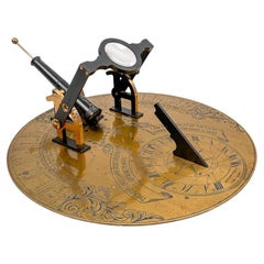
View AllAntique Noon Day Gun Cannon Sundial by Abercrombie & Fitch
By Abercrombie & Fitch
Located in Sandwich, MA
Rare noon day gun cannon sundial by Abercrombie & Fitch circa 1910. Unique garden instrument which fires a small signal charge when the magnifying glass...
Category
Early 20th Century Scientific Instruments
Materials
Metal, Brass
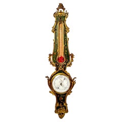
Antique French Ormolu Barometer
Located in Sandwich, MA
Wonderful antique French mercury barometer. Louis XVI ormolu style with elaborate cast bronze leaves and polychrome paint. Features a large squirrel tail thermometer and decorative s...
Category
Antique Late 19th Century French Louis XVI Scientific Instruments
Materials
Bronze
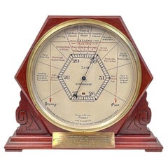
Rare Oversized Stormoguide Barometer by Short & Mason
By Short & Mason
Located in Sandwich, MA
Rare oversized Stormoguide barometer by Short & Mason circa 1930. Possibly made as a store display, this barometer's 12-1/2" dial is over twice the size of the more commonly found St...
Category
Mid-20th Century Scientific Instruments
Materials
Brass
Nantucket Autumn Painting by Andrew Shunney
By Andrew Shunney
Located in Sandwich, MA
Vintage painting "Nantucket Autumn" by Andrew Shunney (American: 1916 - 1978), circa 1960s. Acrylic on canvas modern minimalist Nantucket autumnal landscape with marsh, creek and cot...
Category
Mid-20th Century Paintings
Materials
Acrylic

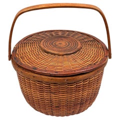
Rare 19th Century Covered Nantucket Basket
Located in Sandwich, MA
Rare antique covered round swing handled Nantucket basket attributed to Charles B Ray circa 1880. Covered 19th C. Nantucket baskets seldom come to ma...
Category
Antique Late 18th Century American Decorative Baskets
Materials
Cane, Rattan
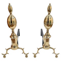
Pair of Antique John Bailey Federal Brass Andirons
Located in Sandwich, MA
Antique pair of brass Federal style double lemon top andirons by John Bailey of New York City circa 1800. Cast iron dogs. Great condition. Measures 23-1/2" high by 11-3/4" wide by 21...
Category
Antique Early 1800s American Andirons
Materials
Brass
You May Also Like
Antique Map of New Ireland, 1774
Located in Langweer, NL
Antique print titled 'Neu Irrland (..)'. Antique map of New Ireland with 7 coastal profiles, Papua New Guinea. Originates from 'Geschichte der See-Reisen u...
Category
Antique 18th Century Maps
Materials
Paper

$275 Sale Price
20% Off
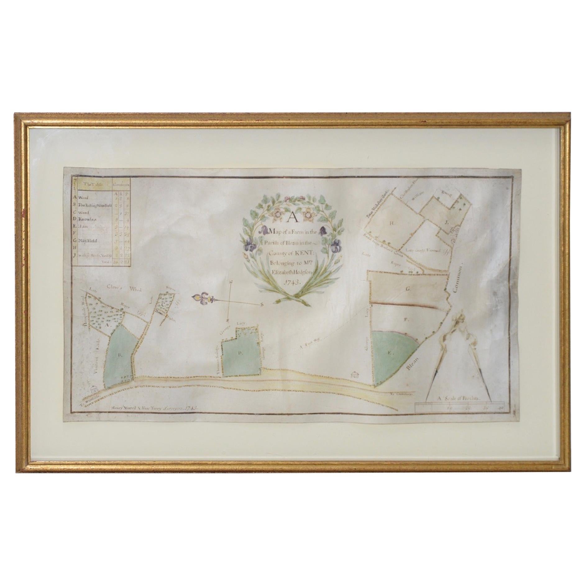
Mid-18th Century Hand Drawn English Farm Map on Vellum, circa 1740s
Located in San Francisco, CA
Mid-18th century hand drawn English farm map on Vellum circa 1740s
Henry Maxted & Isaac Terry, Surveyors.
A Map of a Farm in the Parish of Blean in the County of KENT: Belonging to Mrs Elizabeth Hodgson circa 1743.
A beautiful hand drawn map...
Category
Antique Mid-18th Century English Maps
Materials
Lambskin

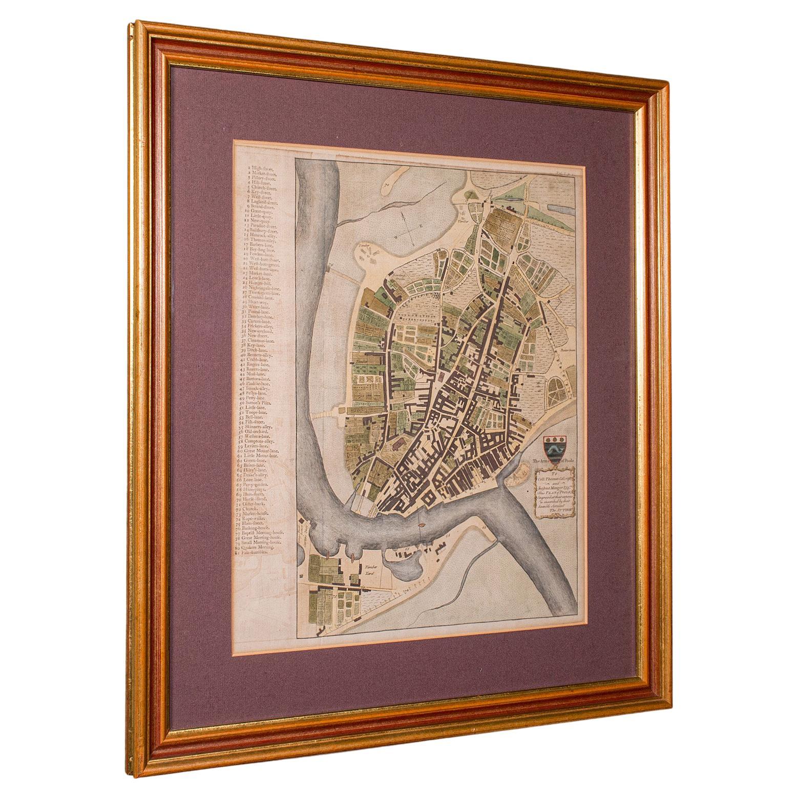
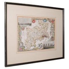
Antique Town Plan Map, Poole, English, Framed Cartography, Georgian, Circa 1780
Located in Hele, Devon, GB
This is an antique town plan map of Poole in Dorset. An English, framed atlas engraving, dating to the 18th century and later.
Fascinating cartography with annotated streets and pl...
Category
Antique Late 18th Century British George III Maps
Materials
Glass, Wood, Paper

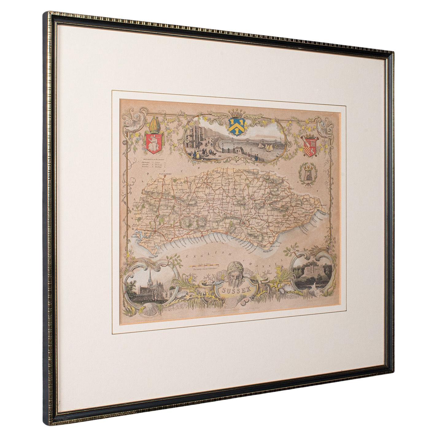
Antique County Map, Sussex, English, Framed Lithography, Cartography, Victorian
Located in Hele, Devon, GB
This is an antique lithography map of Sussex. An English, framed atlas engraving of cartographic interest, dating to the mid 19th century and later.
Superb lithography of Sussex an...
Category
Antique Mid-19th Century British Victorian Maps
Materials
Paper

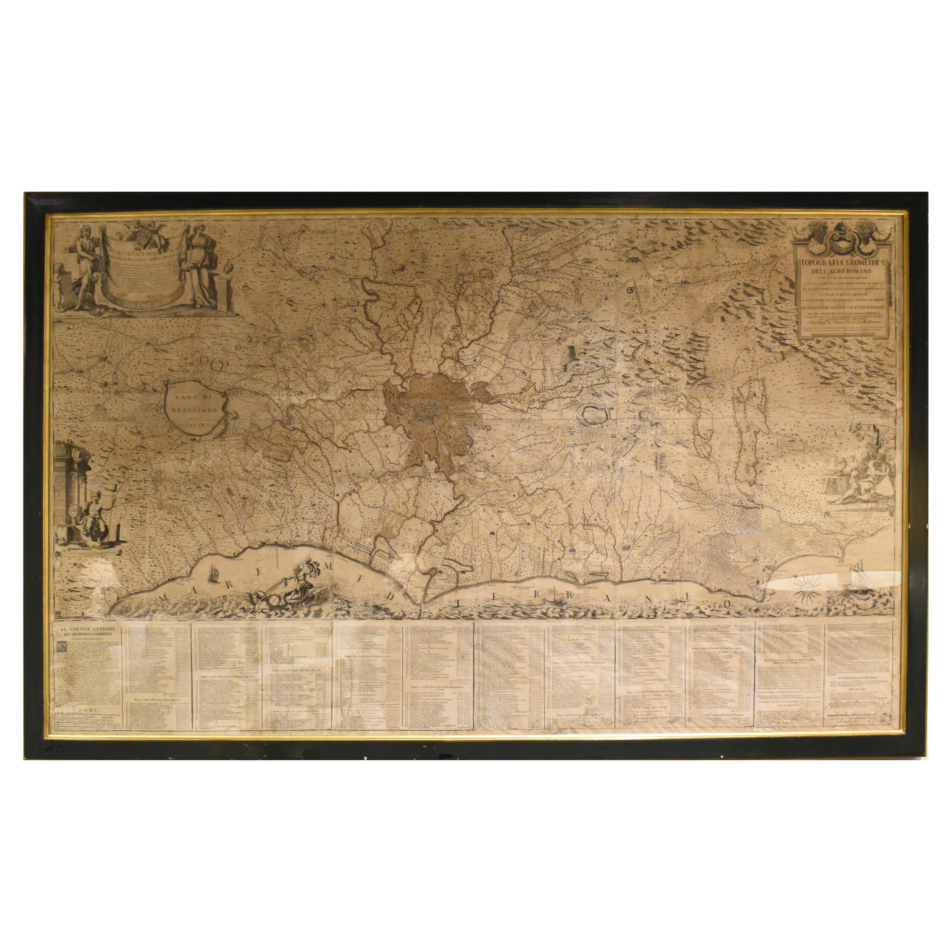
18th Century Map of Rome & Surrounding Vicinity
Located in New Orleans, LA
Intriguing framed map of Rome and the surrounding vicinity featuring detailed cartography, ornamental illustrations, and text index at the bottom. A great, historical conversation pi...
Category
Antique 18th Century Italian Antiquities
Materials
Paper
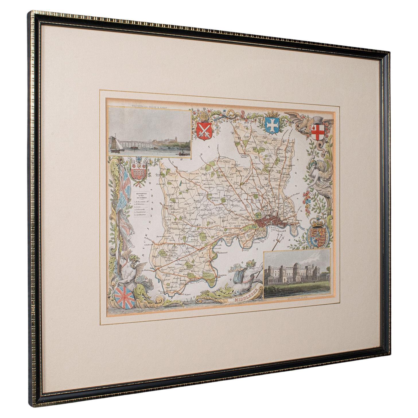
Antique County Map, Middlesex, English, Framed, Litho, Cartography, Victorian
Located in Hele, Devon, GB
This is an antique lithography map of Middlesex. An English, framed atlas engraving of cartographic interest, dating to the mid 19th century and later.
Superb lithography of Middle...
Category
Antique Mid-19th Century British Victorian Maps
Materials
Paper
More Ways To Browse
Newport Furniture
Used Office Furniture Rhode Island
Elios Chair
Plata Lappas
Red Retro Dining Set
Antique Bouquet
Antique Silver Glasses Case
Carlo Scarpa 1934 Chairs
Christofle Marly
1900 Antique Chairs
Glass Table Italian Round
Mid Century Colonial
Alvar Aalto Poster
Geometric Metal Table
Post Modern High Chairs
United Nations
Vintage Vine Rug
Cancel An Order