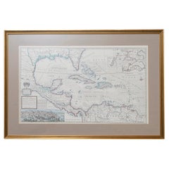
West-Indies Herman Moll William Paterson Spanish Trade Routes Gold
View Similar Items


Want more images or videos?
Request additional images or videos from the seller
1 of 17
West-Indies Herman Moll William Paterson Spanish Trade Routes Gold
About the Item
- Creator:Herman Moll (Artist)
- Dimensions:Height: 22.05 in (56 cm)Width: 33.08 in (84 cm)Depth: 1.19 in (3 cm)
- Style:Baroque (Of the Period)
- Materials and Techniques:
- Place of Origin:Central America
- Period:
- Date of Manufacture:circa 1708
- Condition:Wear consistent with age and use.
- Seller Location:BUNGAY, GB
- Reference Number:1stDibs: LU3867332633902
About the Seller
5.0
Vetted Seller
These experienced sellers undergo a comprehensive evaluation by our team of in-house experts.
Established in 1985
1stDibs seller since 2018
84 sales on 1stDibs
Typical response time: 9 hours
More From This SellerView All
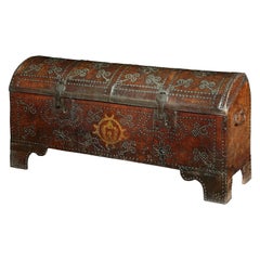
- Arcon Chest Coffer Leather Armorial Spanish Baroque Gilded Brass Studwork DomedLocated in BUNGAY, SUFFOLKRare, early 17th century, Spanish, leather, ‘Arcon’ or domed travelling coffer with a gilded armorial & ornamented with brass studwork. Surviving utalitarian pieces such as travel...Category
Antique 1620s Spanish Baroque Blanket Chests
MaterialsLeather
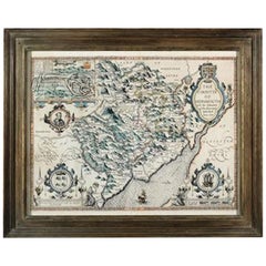
- Countye of Monmouth, Dated 1610By John SpeedLocated in BUNGAY, SUFFOLKThe countye of Monmouth with the situation of the townshire described Anno, 1610 The reverse with Monmouthshire, Chapter VI and an alphabetical list of towns. In a beautiful Flemish oak polished and gilded frame Cartographer: John Speed...Category
Antique 1610s English Baroque Decorative Art
MaterialsPaper
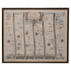
- Road Map John Ogilby No 75 Kings Lyn Harwich, Britannia Framed WallhangingBy John OgilbyLocated in BUNGAY, SUFFOLKThe Road from Kings Lyn Co Norfolk to Harwich Co Essex. By John Ogilby His Majesties Cosmographer. Containing 76 miles, 1 furlong. From Lyn to Swaffam, to Stanford, to Thetford, To Icksworth, to Stowmarket, to Ipswich and to Harwich including ye Ferry, No 75, inscribed in pencil 1698 Hand colored and floated in the original black and gold frame, c1961. Some creasing commensurate with age. The back of the frame inscribed May 1961. Provenance : Private Collection, acquired c1961, along with No 74 Ipswich to Norwich & No 54 London to Yarmouth. All in the original black and gold frames. Sheet width 45cm., 17 ¾”., height 34.5cm., 13 ½“ Frame width 50cm 19 ¾”., height 40cm., 15 ¾” Literature: In a remarkable life John Ogilby pursued, several careers, each ending in misfortune, and yet he always emerged undeterred, to carry on. His modern reputation is based on his final career, started in his sixty-sixth year, as a publisher of maps and geographical accounts. Ogilby was born outside Dundee, in 1600, the son of a Scottish gentleman. While he was still a child, the family moved to London. When the elder Ogilby was imprisoned for debt, the young John invested his savings in a lottery, won a minor prize, and settled his father's debts. Unfortunately, not enough money was left to secure John a good apprenticeship; instead, he was apprenticed to a dance master. Ogilby was soon dancing in masques at court but, one day, while executing a particularly ambitious leap, he landed badly. The accident left him with a permanent limp, and ended his dancing career. However, he had come to the attention of Thomas Wentworth, later Earl of Strafford, Charles I's most senior minister. Ever one to exploit his contacts, Ogilby became a dance instructor in Strafford's household. When Strafford was sent to Ireland, Ogilby accompanied him as Deputy-Master of the Kings Revels, and then Master of Revels. In Dublin, he built the New Theatre, in St. Werburgh Street, which prospered at first, but the Irish Rebellion, in 1641, cost Ogilby his fortune, which he estimated at £2,000, and almost his life. After brief service as a soldier, he returned to England, survived shipwreck on the way, and arrived back penniless. On his return, Ogilby turned his attention to the Latin classics, as a translator and publisher. His first faltering attempt, in 1649, was a translation of the works of Virgil, but after his marriage to a wealthy widow the same year, his publishing activities received a considerable boost. One means by which Ogilby financed these volumes was by subscription, securing advance payments from his patrons, in return for including their name and coats-of-arms on the plates of illustrations. Another approach was to secure a patron, preferably in the court circle. Ogilby's first patron was Strafford, who found out too late that all leading ministers are dispensable when Charles I assented to his execution in 1641. As he re-established himself, Ogilby sought a new patron, the King himself. In 1661, Ogilby was approached to write poetry for Charles II's coronation procession; he later published 'The Relation of His Majesties Entertainment Passing Through the City of London', and a much enlarged edition the following year, which included a Fine set of plates depicting the procession. Royal favour was bestowed in 1674 when John Ogilby received the title of 'His Majesty's Cosmographer and Geographick Printer' with a salary of £13.6s.8d per annum. In 1665, Ogilby left London to avoid the Plague then ravaging the capital. The following year, in the Great Fire of London, Ogilby claimed that he lost his entire stock of books valued at some £3,000, as well as his shop and house, leaving him worth just £5. As he sought to restore his fortunes, Ogilby was already looking in new directions. The initial opportunity he seized on was the reconstruction of London's burnt-out centre. He secured appointment as a 'sworn viewer', whose duty was to establish the property boundaries as they existed before the Fire. Ogilby was assisted in the project by his step-grandson, William Morgan...Category
Antique 1670s European Baroque Maps
MaterialsPaper
- Map Holy Promise Land Canaan Richard Palmer Richard Blome 1687 Joseph MoxonLocated in BUNGAY, SUFFOLKCanaan comonly called the Holy Land or the Land of Promise, being the Possesion of the Israelites & travelled through by Our Lord & Saviour Iesus Christ and his Apostles. Engraven by Richard Palmer for Richard Blome. 1687 Blome, Richard, 1641-1705. London. 283 x 452 mm. Copperplate. Probably from an English Bible...Category
Antique 17th Century British Baroque Maps
MaterialsPaper
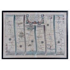
- Map Road Strip Britannia Sheet 2 John Ogilby London Aberistwith Islip BramyardBy John OgilbyLocated in BUNGAY, SUFFOLKFrom John Ogilby's, 'Britannia, an Illustration of the Kingdom of England and Dominion of Wales'. First published in 1675 it remains the greatest advance ...Category
Antique 17th Century English Baroque Maps
MaterialsPaper
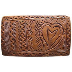
- Box Tobacco 17 Century Friesland Baroque Birch Sliding Lid Love Heart Horse LadyLocated in BUNGAY, SUFFOLKThis romantic and charming box has characteristic carving from the area. With chip-carved geometric decoration to the sliding lid and sides, carved with a horse, two hearts and a...Category
Antique Late 17th Century Dutch Baroque Decorative Boxes
MaterialsBirch

You May Also Like
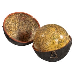
- George III Pocket Globe After Herman MollBy Herman MollLocated in Lymington, HampshireA 3 inch George III pocket globe after Herman Moll, the terrestrial globe inscribed in a cartouche ‘A correct globe with the new discoveries’ and fitted within a hinged black shagreen case, the concave interior of the case applied with the engraved celestial charts...Category
Antique 1770s English George III Globes
MaterialsWood
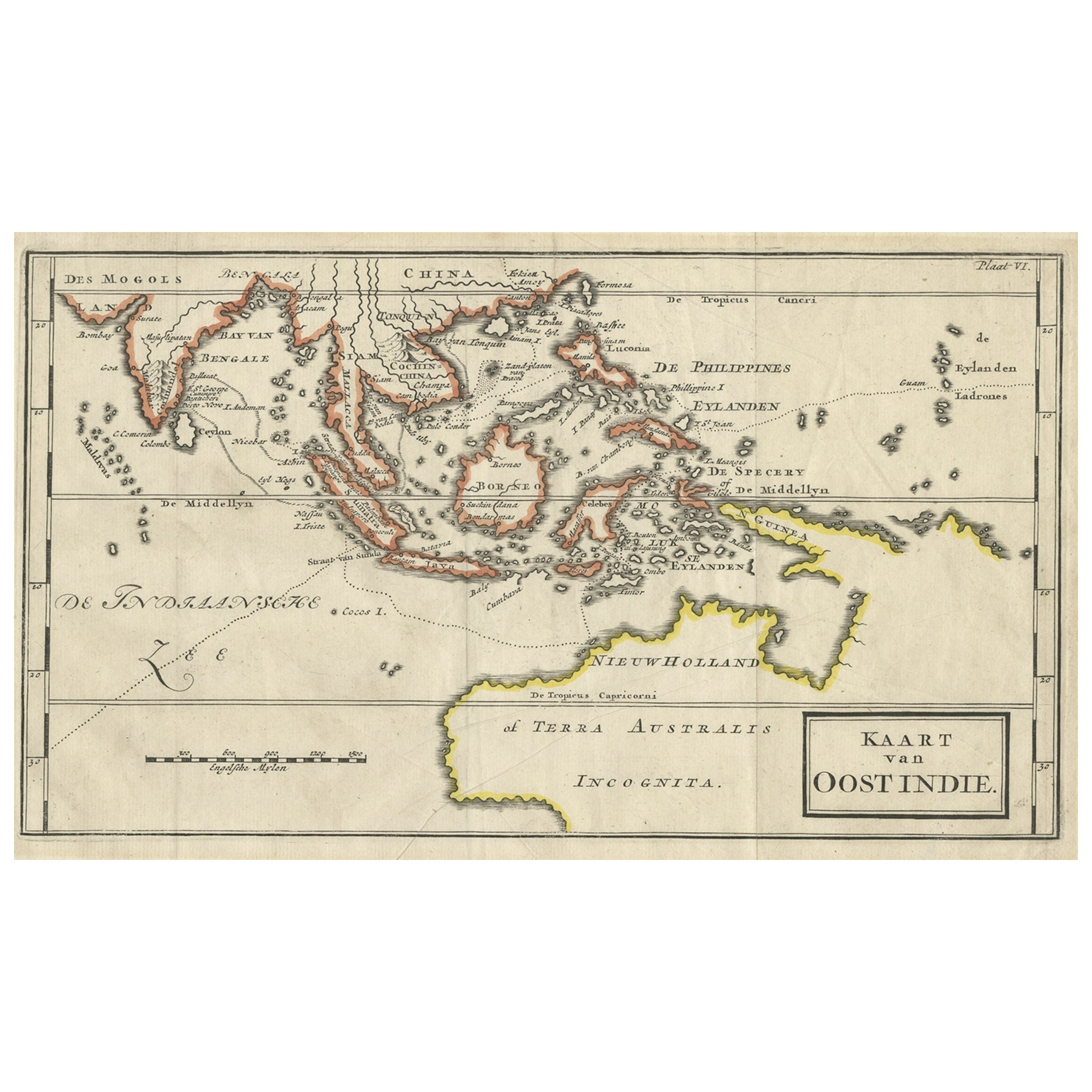
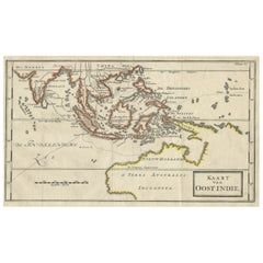
- Map of The East Indies with the Route of Capt. William Dampier's Voyage, 1698Located in Langweer, NLAntique map titled 'Kaart van Oost Indie'. Old map of the East Indies. It shows the routes of Captain William Dampier's voyage throughout the regio...Category
Antique 1690s Maps
MaterialsPaper
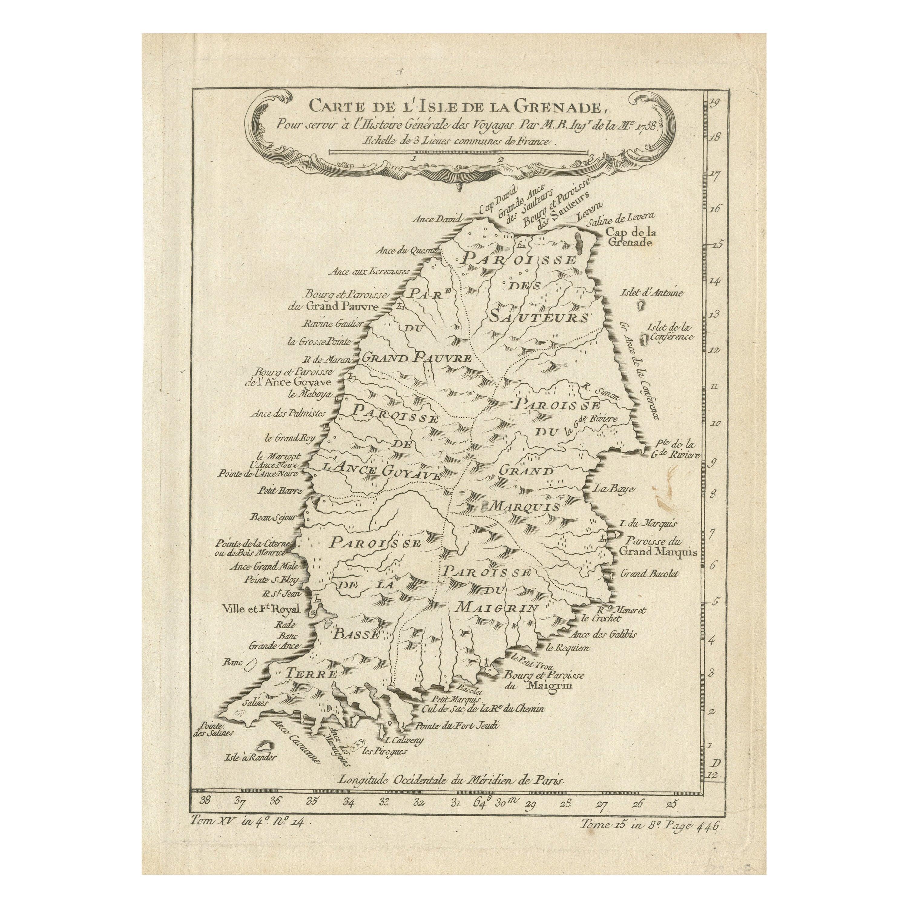
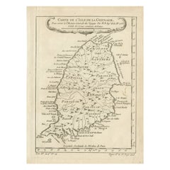
- Antique Map of Grenada, West Indies, 1758Located in Langweer, NL"Exquisite 1758 Map: 'CARTE DE L'ISLE DE LA GRENADE' This alluring map presents a detailed depiction of the Island of Grenada, boasting remarkable intricacy for its time. Notably, i...Category
Antique 1750s Maps
MaterialsPaper
- Antique Map of Denmark by Moll 'circa 1730'By Herman MollLocated in Langweer, NLAntique map titled 'Denmark, agreeable to Modern History'. Uncommon map of Denmark by Herman Moll, published, circa 1730.Category
Antique Mid-18th Century Maps
MaterialsPaper
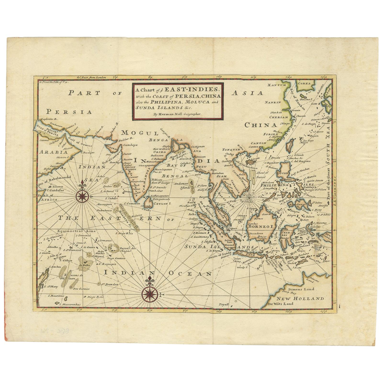
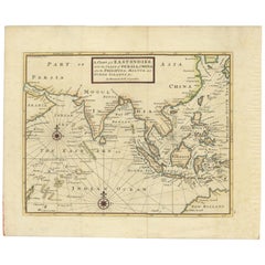
- Antique Map of the East Indies by Moll '1745'Located in Langweer, NLAntique map titled 'A Chart of ye East-Indies. With the Coast of Persia, China also the Philipina, Moluca and Sunda Islands'. Detailed map of the Indian Ocean, Southeast Asia, China,...Category
Antique Mid-18th Century Maps
MaterialsPaper
 $642 Sale Price35% Off
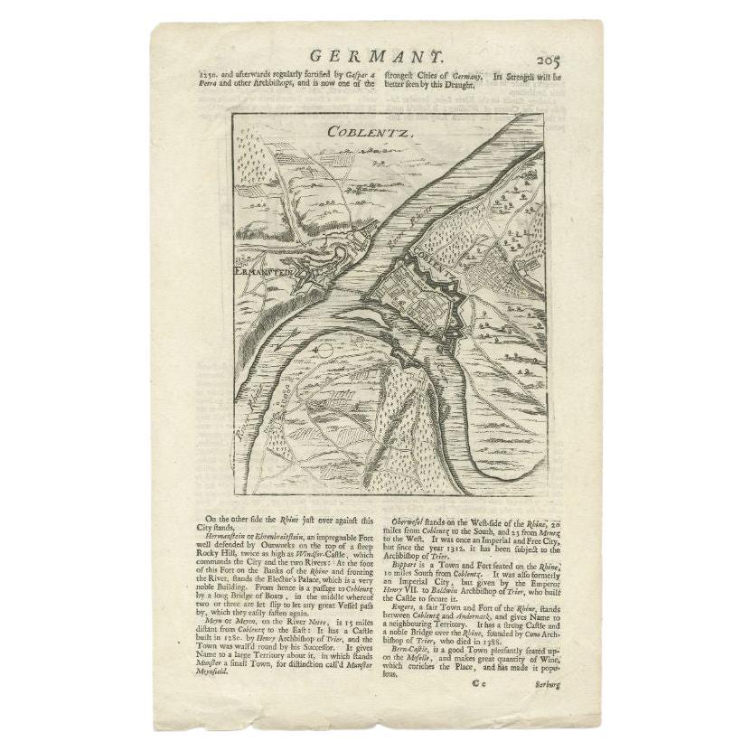
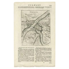
 - Antique Map of the Koblentz Region by Moll, 1695By Herman MollLocated in Langweer, NLAntique map Koblentz titled 'Coblentz'. Rare antique map of the Koblentz region in Germany. On verso, an antique map of the Mont Royal fortress, Germany. Originates from 'Thesaurus G...Category
Antique 17th Century Maps
MaterialsPaper

Recently Viewed
View AllMore Ways To Browse
New West Furniture
Trade Show Furniture
Southern America Furniture
Southern American Furniture
Used Trade Show Furniture
West Indies
Bank Of England
William Cross
Antique Furniture North West
Southern New And Used Furniture
Trading Places
Antique Trade Show
West Indies Furniture
Furniture West Indies
Antique Furniture West London
Mexican 18th Century
Spanish Granada
West Indies Antique Furniture